Smoke maps and Red Flag Warnings, September 1, 2015

AIRPACT smoke forecast
AIRPACT smoke forecast (PM2.5) for the Northwest, for 5 p.m. PT, September 1, 2015.
NOAA smoke forecast
NOAA smoke forecast for 5 p.m. PT, September 1, 2015.
Smoke conditions
Smoke conditions, morning of September 1, 2015. The brown circular icons represent the locations of wildfires. AIRNOW.

wildfire Red Flag Warnings 9-1-2015

The National Weather Service has issued Red Flag Warnings or Fire Weather Watches for areas in California, Nevada, Wyoming, and Montana.

The map was current as of 9 a.m. MDT on Tuesday. Red Flag Warnings can change throughout the day as the National Weather Service offices around the country update and revise their forecasts and maps. For the most current data visit this NWS site or this NWS site.

To see the most current smoke reports on Wildfire Today, visit the articles tagged “smoke” at https://wildfiretoday.com/tag/smoke/

Smoke map and Red Flag Warnings, Aug. 29, 2015

Red Flag Warnings, Aug. 29, 2015, noaa.gov

The National Weather Service has issued Red Flag Warnings for areas in California, Nevada, Washington, Idaho, Wyoming, North Dakota and Montana.

The map was current as of 8:45 a.m. MDT on Saturday. Red Flag Warnings can change throughout the day as the National Weather Service offices around the country update and revise their forecasts and maps. For the most current data visit this NWS site or this NWS site.

Smoke from western wildfires continues to generate air quality advisories across the west, while the heaviest smoke drifts northeast towards Canada and the midwest.

Smoke map, Aug. 29, 2015
Smoke map, Aug. 29, 2015. AirNow.gov.

The map below shows the active spreading for smoke over the next 24 hours. To see the active map, visit this site. 

Smoke map, Airimpact
Smoke map, Airimpact, Aug. 29, 2015

To see the most current smoke reports on Wildfire Today, visit the articles tagged “smoke” at https://wildfiretoday.com/tag/smoke/

Smoke map and Red Flag Warnings, Aug. 28, 2015

Red Flag Warnings, Aug. 28, 2015

The National Weather Service has issued Red Flag Warnings or Fire Weather Watches for areas in California, Washington, Nevada, Wyoming, Idaho and Montana.

The map was current as of 9 a.m. MDT on Friday. Red Flag Warnings can change throughout the day as the National Weather Service offices around the country update and revise their forecasts and maps. For the most current data visit this NWS site or this NWS site.

Heavy smoke from northwestern fires continues to drift into Canada, although as of Friday morning, the smoke was less severe than it had  been in previous days.

Smoke Map, Aug. 28, 2015. AIRNow.gov

To see the most current smoke reports on Wildfire Today, visit the articles tagged “smoke” at https://wildfiretoday.com/tag/smoke/

Smoke map and Red Flag Warnings, Aug. 27, 2015


Red Flag Warnings, Aug. 27, 2015. noaa.gov

The National Weather Service has issued Red Flag Warnings or Fire Weather Watches for areas in Washington and Montana.

The map was current as of 9 a.m. MDT on Thursday. Red Flag Warnings can change throughout the day as the National Weather Service offices around the country update and revise their forecasts and maps. For the most current data visit this NWS site or this NWS site.

Smoke map, Aug. 27 2015. AIRNow.gov.

Heavy smoke from northwestern wildfires is continuing to blanket southern Canada. Unhealthy levels of smoke have been forecasted for central and western Canada, in Alberta and British Columbia, as well as northern Washington, Idaho and Montana.

Air Quality map, Aug. 27, 2015, AIRNow.gov

To see the most current smoke reports on Wildfire Today, visit the articles tagged “smoke” at https://wildfiretoday.com/tag/smoke/

Smoke map and Red Flag Warnings, August 24, 2015

(UPDATE at 5:23 p.m. PT, August 24, 2015)

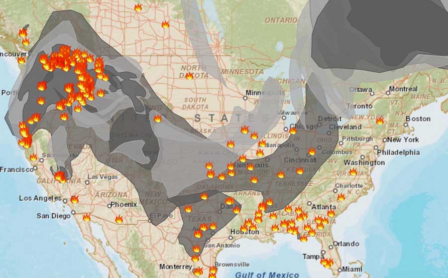
Wildfire smoke map
Wildfire smoke map, evening of August 24, 2015.

****

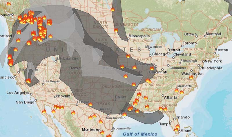
Map of smoke from wildfires
Map of smoke from wildfires, morning of August 24, 2015.

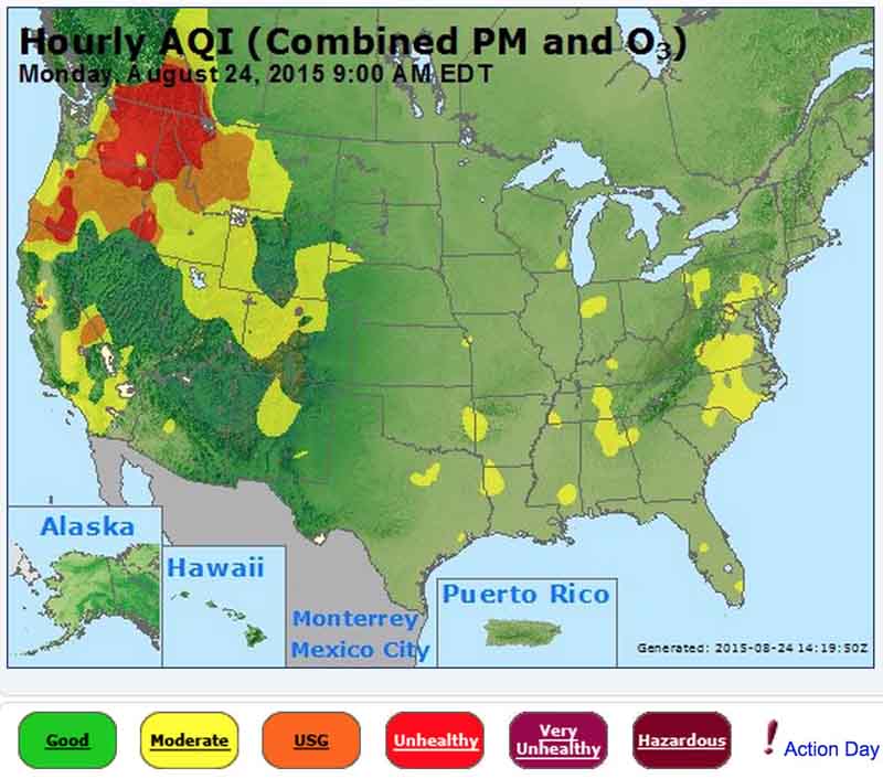
Areas in Washington, Oregon, Idaho, Montana, and California have “unhealthy” air quality, at least partially caused by smoke from wildfires.

Air quality affected by wildfire smoke
Air quality affected by wildfire smoke. AirNow.

The National Weather Service has issued Red Flag Warnings or Fire Weather Watches for areas in Washington, Oregon, Idaho, Montana, and California.

The map was current as of 8 a.m. MDT on Monday. Red Flag Warnings can change throughout the day as the National Weather Service offices around the country update and revise their forecasts and maps. For the most current data visit this NWS site or this NWS site.

wildfireRed Flag Warnings Aug 24, 2015

To see the most current smoke reports on Wildfire Today, visit the articles tagged “smoke” at https://wildfiretoday.com/tag/smoke/

Red Flag Warnings, August 23, 2015

wildfireRed Flag Warnings Aug 23, 2015

The National Weather Service has issued Red Flag Warnings or Fire Weather Watches for areas in Washington, Oregon, Idaho, Montana, and California.

The map was current as of 8 a.m. MDT on Sunday. Red Flag Warnings can change throughout the day as the National Weather Service offices around the country update and revise their forecasts and maps. For the most current data visit this NWS site or this NWS site.