


(UPDATE at 9:10 a.m. MDT, June 30, 2013)
For the last several days the weather has been in favor of the firefighters. Saturday brought rain over most of the Complex, with accumulations of 0.02 to 0.20 inches, however in some areas it did not penetrate tree canopies in areas with heavy timber. Smoke prevented most aerial firefighting Saturday but helicopters and air tankers will be in the air Sunday if they are needed and weather permits. Thunderstorms are in the forecast for the next few days. Winds on Sunday will be out of the Northwest at 5-15 mph, with a 60% chance of rain actually hitting the ground.
The Incident Management Team reports the fire is two percent contained and the three fires in the complex have burned 95,775 acres: Windy Pass 1,415, Papoose 34,836, and West Fork 59,524 acres.
Resources on the fire include 8 Type 1 hand crews, 20 Type 2 hand crews, 109 engines, 5 dozers, and 11 water tenders, for a total of 1,502 personnel.
****
(UPDATE at 9:20 a.m. MDT, June 28, 2013)
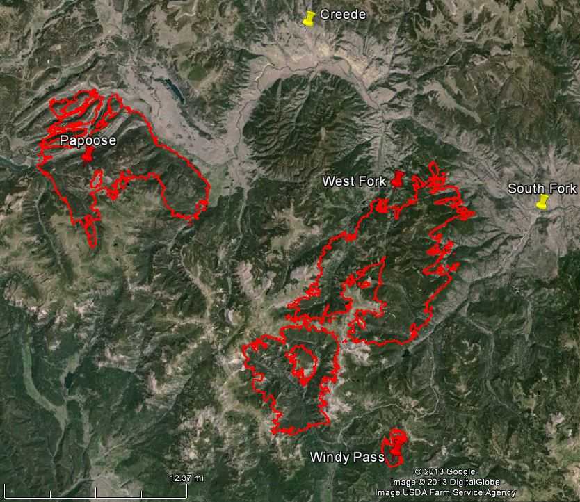

The Papoose Fire, pushed by 30 to 40 mph northwest winds out of a thunderstorm, ran for about four miles on the east side Thursday, southwest of Antelope Park. Adding approximately 6,000 acres, it became established in Trout Creek and threatened to spread up the east side of the drainage. The fire spread through beetle-killed Englemann Spruce spotting one mile to one and a half miles ahead, according to the Incident Management Team spokesperson, who reported that firefighters burned around some structures to remove the fuel before the fire hit those areas — here were no reports that any burned.
The West Fork Fire was much quieter than the Papoose Fire, but it was somewhat active near Elk Mountain and on the southeast side.
The incident Management Team reports the three fires in the Complex have burned a total of 90,056 acres.
The weather forecast for the Antelope Park area south of Creede calls for 78 degrees, relative humidity in the mid-20s, about a 30 percent chance of thunderstorms, and winds out of the southwest at 8 to 15 mph.
****
(UPDATE at 10:50 a.m. MDT, June 27, 2013)
More information has become available about the West Fork Complex:
The Papoose Fire was active Wednesday night and moved into Crooked Creek and towards Rio Grande Dam. It moved past structures near Workman Creek along Highway 149 but there was no report of damage to structures. Firefighters worked through the night to reinforce firelines, protect structures, and conduct firing operations along Squaw Creek to remove fuels in front of the fire.
The West Fork Fire has been active on the northeast flank near Elk Mountain. Structure protection, including sprinklers, is in place along Highways 149 and 160.
Portable fire retardant plants have been set up near the Papoose Fire and on the east side of the West Fork Fire. These will be used for refilling buckets and tanks on helicopters. Dropping fire retardant will be more effective than using plain water.
Current acreage for the whole Complex: Total 83,004; Windy Pass 1,403; Papoose 26,483; West Fork 55,118.
Shortly after 9 a.m. today two military MAFFS C-130 air tankers were dispatched to the West Fork Fire from their base at Colorado Springs where another portable fire retardant base has been established.
The Incident Management Team is now putting various types of information in at least four different places: Google Drive (which I can’t get to work), Facebook, Photo Bucket, and Inciweb. Apparently this IMTeam has said goodbye to the concept of putting all information about a fire in one place, possibly due in part to the dysfunctional InciWeb.
****
(UPDATE at 7:20 a.m. MDT, June 27, 2013)

The satellite that passed over the West Fork Complex twice in the last 24 hours has not found as many heat sources as in previous days. But the instruments can only detect areas of heat that are at least 30 meters by 30 meters.
Dozers have finished constructing a fireline between the fire and the town of South Fork and fire crews are continuing to work around the structures on Highway 149. Not much other new information is available, other than the Incident Management Team reported that they held some internal meetings and briefings. The fire’s InciWeb page has not been updated since Wednesday morning.
****
(UPDATE at 10:40 p.m. MDT, June 25, 2013)
The West Fork Fire has been burning for 20 days, and on day 20 a usable map of the fire was posted on InciWeb by an Incident Management Team running the fire. And instead of placing photos of the fire on InciWeb, they are putting them on something called “Photo Bucket” under West Fork Complex, according to a message sent out by the team. In addition the IMTeam is posting some information on Facebook, “dedicated to thank yous to the firefighters working on the fire line” according to a Tweet the Information Officer published. Of course, InciWeb is virtually unusable, so they can hardly be blamed for partially abandoning it and only updating InciWeb rarely. Apparently this IMTeam has said goodbye to the concept of putting all information about a fire in one place.
As the weather moderates, the IMTeam expects the fire to become more fuel (or vegetation)-driven, rather than wind-driven as has been for the last one to two weeks. On Tuesday an increase in humidity caused the fire to spread more slowly and allowed firefighters to make more progress than they have been used to, especially on the west side.
The Papoose Fire still remains south of highway 149 and Creede has not been evacuated, in spite of reports to the contrary. One of the DC-10 air tankers dropped retardant on the west side of the fire today, at a rate of 11,600 gallons per sortie.
****
(UPDATE at 8:25 a.m. MDT, June 25 2013)

There was not much change in the perimeters of the Papoose, West Fork, and Windy Gap fires over the last 24 hours. Each of them grew a bit, but there was no major change in acreage. The West Fork Fire is still about four miles from the intersection of Highways 160 and 149.
The Incident Management Team this morning said: “Current acreage per infrared flight last night: West Fork 54,222; Papoose 23,605; Windy Pass 1,355 TOTAL for complex, 79,182”
****
(UPDATE at 7:50 a.m. MDT June 24, 2013)
There has not been a great deal of change in the perimeters of the West Fork, Papoose, and Windy Pass Fires over the last 24 hours. They all grew — Windy pass by a few hundred and West Fork and Papoose by a few thousand.
The approximate acreages now:
53,000 West Fork
21,000 Papoose
1,250 Windy Pass
74,250 TOTAL for the West Fork Complex
The West Fork Fire has been the most active on the north end and near Sheep Mountain. It is still approximately four miles from the intersection of Highways 160 and 149.
The Papoose Fire’s main activity has been on the north and northeast sides. Firefighters are continuing to hold it south of Highway 149. A spike camp has been established for the firefighters working on the Papoose Fire in order to reduce travel times.
For information on evacuations check www.acemergency.org.
****
(UPDATE at 7:50 p.m. MT, June 23, 2013)

When the satellite passed over the West Fork and Papoose Fires at 3:05 p.m. Sunday it not find a lot of new heat sources on the West Fork Fire. However the Papoose Fire had new heat detections on the west and northeast sides. Keep in mind that there was potential for the fire to grow significantly after 3 p.m.
At 4:06 the Incident Management Team sent this tweet:
#WestForkFire The fire is considered a plume dominated fire and spotting is possible.
— RMT1PIO (@rmt1pio) June 23, 2013
But he also said that most of the burning was in the interior of both fires, implying that there was not a lot of additional fire spread at the perimeters.
The term “plume dominated” means a massive convection column of smoke powerful enough to affect the fire behavior of a large portion of the fire through indraft winds and new spot fires out ahead of the main fire.
A nearby weather station at 7 p.m. Sunday recorded a relative humidity of 6 percent and 15 mph southwest winds gusting to 24 mph — weather that is very conducive to rapid fire spread. The forecast for Monday is similar, single-digit humidity and southwest winds gusting up to 34.
The Incident Management Team running the fire has established a Facebook page where people can drop by and leave a comment, hopefully positive, for the firefighters working on the fire.
****
(UPDATE at 7:40 a.m. MDT, June 23, 2013)


The West Fork Fire continued to move closer to South Fork, Colorado on Saturday. As of about 12:30 a.m. Sunday it was approximately four miles from the intersection of Highways 160 and 149. The fire grew by about 8,000 acres, increasing its total to 49,000.
The Papoose Fire also grew by about 8,000 acres to approximately 19,000 acres. It has approached to within a half mile of Highway 149 and is about 11 miles from Creede. The long range spotting from Friday’s plume dominated fire behavior resulted in significant growth on the northwest and northeast sides. Creede is under a pre-evacuation notice.
The Windy Pass Fire, the third fire in this Complex, was less active than the other two, and has burned about 980 acres.
All three fires in this Complex have burned approximately 68,000 acres.
No structures have burned but 750 “primary” structures are threatened.
Below is an official update from the Incident Management Team released at about 7 a.m. Sunday. It appears to have been written Saturday evening.
Briefing for residents at 9 am on Sunday June 23 at the Red Cross Evacuation Center
Papoose Fire: The Papoose Fire, southwest of Creede, continued to move to the north. It is threatening about 25 residences just south of the Rio Grande River along the 149 highway corridor. Crews have been working all day in that are to protect the structures.
West Fork Fire: The fire is still southwest of the town of South Fork. Firefighters continue to patrol and protect the town and outlining subdivisions and along the 160 corridor. In the afternoon the northern flank of the fire, south of Highway 149 in the Wagon Wheel Gap area, burned actively putting up a significant column. Heavy smoke prevented fire managers from determining the full extent of the fire in that area. On the southern flank, the fire was more active today than it has been all week. It made a run up the back side of Sheep Mountain to the east and is burning above Highway 160. Firefighters continued to protect all structures and cabins at Borns Lake.
Windy Pass Fire: The Windy Pass Fire, which is burning in an area with less dense vegetation than the other two fires, made a few short runs towards Lane Creek. Firefighters have been able to hold the Windy Pass Fire within the established indirect containment lines and there has been no damage to the Wolf Pass Ski Area.
Evacuations: There are multiple ongoing evacuations and pre-evacuations. For the most up-to-date information on evacuations please go to www.acemergency.org.
Closures: Again, there are multiple road and trail closures the primary ones are Highway 160 from the chain-up area to South Fork, and Highway 149 between South Fork and Creede from mile post 1 through milepost 22.
****
(UPDATE at 4:20 p.m. MDT, June 22, 1013)

These maps show heat detected by a satellite at 2:20 p.m. MDT, June 22. Click on the maps to see a larger version. The locations of the square icons can be as much as a mile in error. The red icons are the most recent. The Papoose Fire in the top-right, or northwest corner in the map above was more active at 2:20 p.m. today than the West Fork, the larger fire in the middle. The Windy Pass Fire at the very bottom of the image (the four yellow squares) was active, but just off the image.

The above map of the West Fork fire is approximately what it would look like if you were flying about 5,000 feet above South Fork, looking west. The multi-colored squares representing heat detected by a satellite become distorted by Google Earth when viewed at such a low 3-D angle. According to the data from the satellite at 2:20 p.m. today, the West Fork fire was still approximately 5 miles from the intersection of highways 160 and 149 at South Fork, which is adjacent to the label “South Fork” in the image above.
There is one thing in the favor of the firefighters and the residents of South Fork. As you can see in the photo, the vegetation, that is, the fuel, becomes lighter and less dense — fewer tons per acre in the vicinity of the community. More brush and grass as opposed to timber at the higher elevations. This will make it somewhat easier to protect the town, using all the tools in the firefighter’s tool box, including fire engines, hose lays with water, backfires, burnouts, and aerial firefighters in air tankers and helicopters.
****
(UPDATE at 12:33 p.m. MDT, June 22, 2013)
Current information on the West Fork Complex Fire on the San Juan National Forest in Colorado has been difficult to find, probably due in part to the transitions through various Incident Management Teams. The Complex now consists of three fires. The Papoose Fire has been added to the complex that already contained the West Fork and Windy Pass Fires.
Below is information provided by the IMTeam Saturday morning, current as of 9 a.m.:
A RED FLAG warning has been issued for today; this is the fourth day in a row where conditions are ideal for rapid fire spread and for the chances of any ignition source starting new fires. Winds that have been pushing the fires will continue from the southwest at 15 to 20 mph with gusts to 35 mph wind gusts up to 50 mph on exposed ridges. The fires are again expected to make significant runs. The size for the West Fork Fire Complex that now includes the Papoose Fire [and the other two fires] is 53,544 acres.
Papoose Fire: The Papoose Fire, southwest of Creede, made a significant run to the north yesterday afternoon going from approximately 2,000 acres to more than 11,000 acres. It is burning near the Road Canyon Reservoir, 30-Mile Campground and threatening subdivisions in the area. Resources from the West Fork Fire are being moved to Papoose to assist with structure protection.
West Fork Fire: Fire behavior on the east flank of the West Fork fire was moderated yesterday by the extensive use of air tankers. As of this morning the fire was still southwest of South Fork about 7 miles. Most of the fire activity yesterday was a result of the two heads of the fire burning together. This pulled the eastern flank of the fire toward the north. Structure protection will continue along the Highway 160 corridor. Firefighters were able to hold the fire from spreading to the south and all structures and cabins at Borns Lake were not affected by yesterdays fire activity. West Fork Fire is 42,516 acres.
Windy Pass Fire: The Windy Pass Fire, which is burning in an area with less dense vegetation than the other two fires, grew only slightly yesterday to a total of 937 acres. Firefighters have been able to hold the Windy Pass Fire within the established indirect containment lines and there has been no damage to the Wolf Pass Ski area.
****
(UPDATE at 10:53 a.m. MDT, June 22, 2013)
Bob, one of our loyal readers, pointed out to us today that 16 days and 41,000 acres ago the West Fork Fire was reported by the Rocky Mountain Coordination Center (RMCC) as being less than an acre and was being managed as a “monitor” fire, that is, it was going to be watched but not necessarily fully suppressed. After that, the strategy changed to “confine/contain”, which involves herding it around and suppressing portions of it if necessary. And finally today the report from the RMCC says managers on the San Juan National Forest decided that full suppression is the best strategy.
As we wrote on June 20:
It will be interesting to watch the progression of this ‘confine and control’ fire with at least three months remaining in the fire season.
Excerpts from the “News and Notes” section of the RMCC web site are below:

****
(UPDATE at 9:15 a.m. MDT, June 22, 2013)

The map of the West Fork and Papoose Fires shows heat detected by a satellite at 11 p.m. MDT, June 21. Click on the map to see a larger version. The locations of the square icons can be as much as a mile in error. The red icons are the most recent. According to the satellite data at 11 p.m, the West Fork Fire was approximately 5 miles from the intersection of highways 160 and 149 at South Fork. However, the fire was still extremely active and spreading at that time.
Two Incident Management Teams are on scene, Bob Houseman’s NIMO Team, and Pete Blume’s Type 1 Team. In addition, Saturday night Jim Loach’s Area Command Team was dispatched to coordinate the fires in this area.
Two military C-130 MAFFS air tankers in California have been activated and should arrive in Colorado either Saturday or Sunday. They will join the first two that were mobilized from Peterson Air Force Base at Colorado Springs.
Below is information from the Incident Management Team as of 5 p.m. Friday:
Very active fire behavior at time of submission of this report. Values at risk are being assessed. Additional evacuations and closures are being evaluated. The long range spotting from yesterday’s plume dominated fire behavior resulted in significant growth north and east of the Continental Divide on the Rio Grande National Forest.
Evacuations were initiated by Mineral County for areas along Highway 160. The communities of South Fork and Wagon Wheel have been evacuated. The community of Creede is under a pre-evacuation notice. Additional resources being ordered for structure protection.
Area closures on the San Juan and Rio Grande National Forest were expanded.
The Papoose Fire, five miles west of the West Fork, exhibited extreme growth to the northeast heading towards Highway 149 which is approximately fire miles ahead of this fire.
Rio Grande Forest Road 520 is closed. Highway 160 was closed to traffic at Treasure Falls on the west side and west of city limits of South Fork on the east side.
The strategy on the incident is focused on indirect and point protection tactics. Indirect line on the Windy Fire is utilizing topographic features and fuel changes where probability of success is highest.
The West Fork Fire exhibited extreme fire behavior in the Weminuche Wilderness areas. Terrain and bug kill prevents suppression in the wilderness. Structure protection is in place in the West Fork-Borns Lake and Wolf Creek Ski Area. Major smoke impacts to Highway 160 and communities to the north and east of the fire.
Pete Blum’s Type 1 Team on scene.
****
(UPDATE at 8:30 p.m. MDT, June 21, 2013)
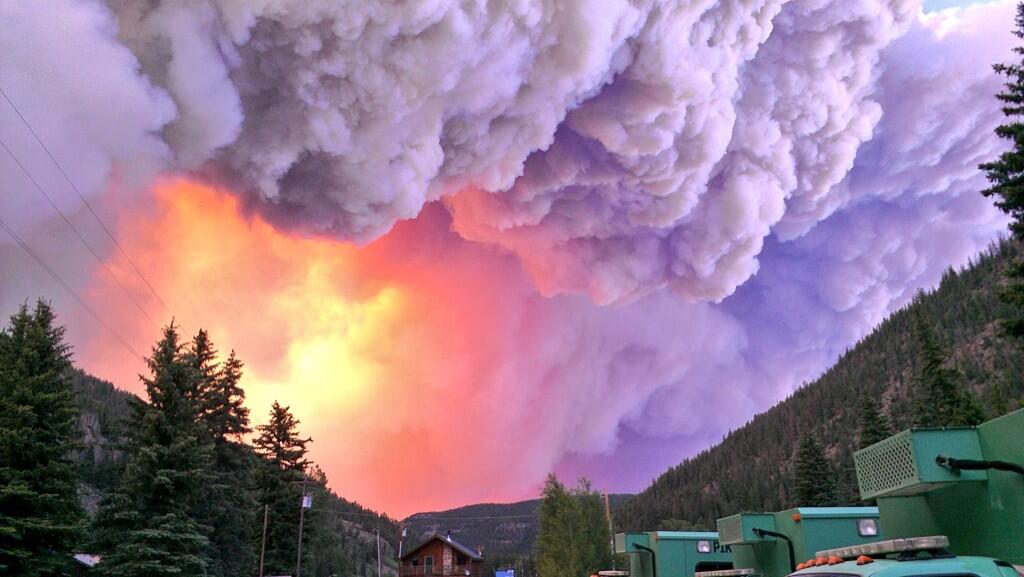
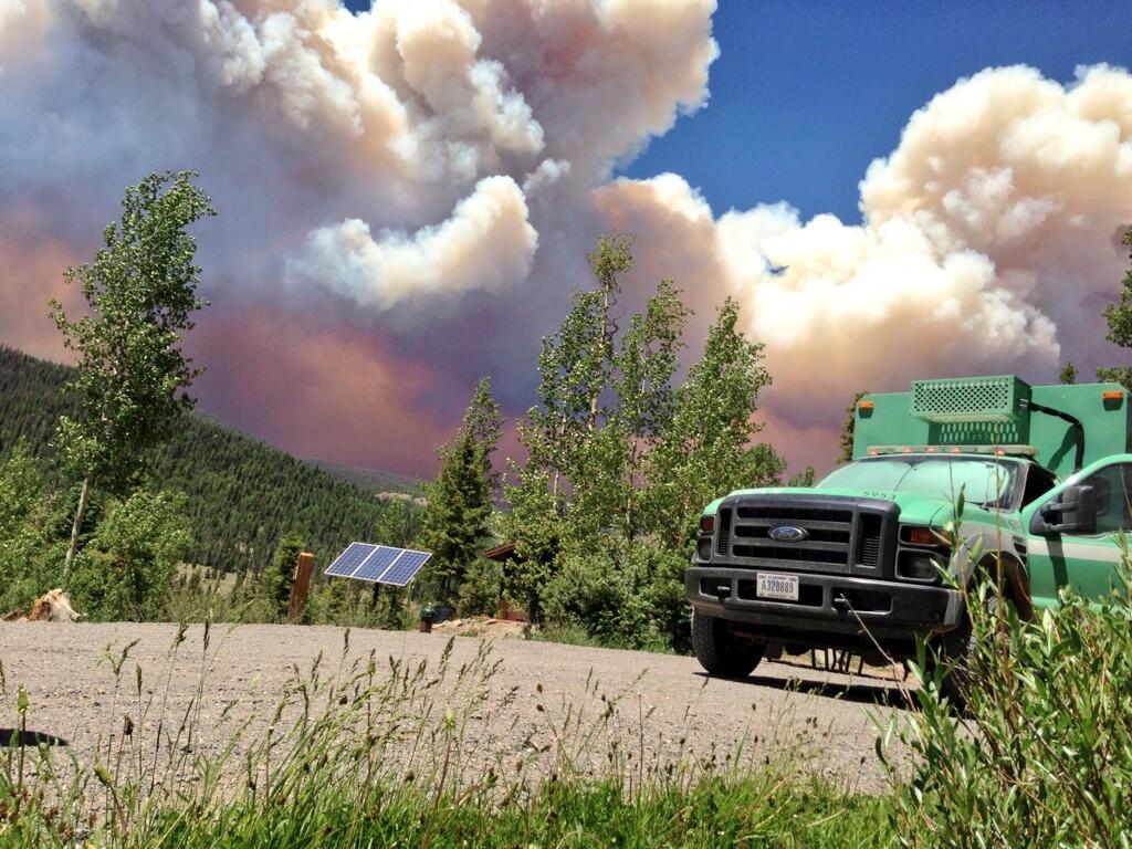
The town of South Fork is under a mandatory evacuation order, stretching from the top of Wolf Creek Pass to and including the town. According to the Archulate County Emergency Information web site, residents can shelter at the Del Norte High School, and large animals and RVs can be taken to the Sky High Complex in Monte Vista.
At 3:36 p.m. today the County’s web site said the fire was two to three miles west of South Fork and it may progress to community later in the day. At least 32 fire engines and a number of hand crews are currently protecting the town. Electricity has been turned off in the town and much of the surrounding area.
****
(UPDATE at 1:10 p.m. MT, June 21, 2013)

The map of the West Fork fire above shows the fire perimeter as it was at about 1 a.m. Friday, June 21. It has been growing at a very rapid rate for the last two days and last night approached to within about 7 miles of South Fork in south-central Colorado. The estimated size is 29,000 acres.
Some of the burn has been a little spotty, possibly due to the non-continuous vegetation. Most of the fire is 10,000 to 11,000 feet above sea level, but if it continues to move to the northeast toward South Fork it will encounter lower elevations and more continuous fuel and may offer even more resistance to control.
The smaller fire south of Hwy 160 is the Windy Pass fire which has burned about 800 acres.
The Incident Management Team described Thursday’s fire spread:
Fire behavior on the West Fork fire was extreme; it made a close to 7-mile -run in a northeasterly direction. Eric Norton, Fire Behavior Analyst for the NIMO Team, said The fire behavior we saw yesterday was so extreme, it was undocumented and unprecedented The fire more than doubled in size going from 12,001 acres to close to 29,000 acres today. The fire burned in a northeasterly direction crossing the Continental Divide and burning on the ridge above Big Meadows Reservoir down to Metroz Lake. In some locations the fire is only ½ mile from Highway 160. Firefighters were able to hold the fire from spreading to the south and all structures and cabins at Borns Lake were not affected by yesterdays fire activity.
There are multiple ongoing evacuations and pre-evacuations. For the most current information on evacuations visit www.acemergency.org or call 970 731-2745.
****
(UPDATE at 5:58 p.m. MDT, June 20, 2013)

****
(UPDATE at 2:35 p.m. MDT, June 20, 2013)

The photo above of the West Fork Fire was taken from the Durango, Colorado Air Tanker Base 50 miles southwest of the fire at about 12:30 local time Thursday, June 20, 2013. The object at the top of the photo is Helitanker 740, a Skycrane.
****
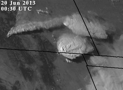
After writing about the pyrocumulus and the 200-mile smoke plume generated by the West Fork Fire in south-central Colorado yesterday, we discovered this morning that the strategy the U.S. Forest Service selected for this fire is “confine and control”, rather than full suppression. Wednesday morning the fire, which is 13 miles north of Pagosa Springs, was 3,280 acres and by late Wednesday night it was well over 12,000 acres. The Rocky Mountain Coordination Center reported Wednesday that a Type 3 Incident Management Team (Schlapfer/Kincaid) was running the fire but later in the day a Type 1 NIMO IMTeam with Incident Commander Curtis Heaton assumed command.
Below is an excerpt from the Incident Status Summary filed by the fire managers at 5 p.m. Wednesday:
Extreme fire behavior observed at the time of submission of this report. 100 foot flame lengths observed, group tree torching with short crown runs. Long range spotting up to 3/4 of a mile. The same is expected in tomorrow’s behavior. Red Flag Warning in effect.
Part of the fire is burning in the Weminuche Wilderness areas where, the report said, no suppression efforts were made due to unacceptable risks to firefighters caused by steep terrain and bug killed trees.
It will be interesting to watch the progression of this “confine and control” fire with at least three months remaining in the fire season.







