


Above: Power line repair, Erskine Fire. Undated uncredited photo from InciWeb.
(UPDATED at 9:17 a.m. PDT June 28, 2016)
Most of the evacuation orders have been lifted for residents that were forced to leave their homes during the Erskine Fire near Lake Isabella, California.
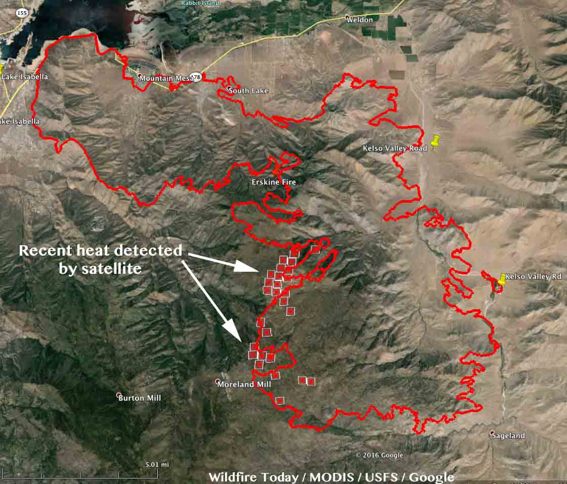
The latest satellite overflight showed much-reduced heat on the Erskine Fire, only detecting heat on the southwest side where there was some westward movement of the fire. This does not mean the rest of the fire is out. The satellite is hundreds of miles away and only finds the larger heat sources. There is no doubt some fire activity in other areas, but this latest data does show that much of the fire is not still spreading.
Highway 178 is now open. However some roads off of Highway 178 remain closed, including Entrada, McCray Rd, Dogwood, Kelso Valley Rd and Kelso Creek Rd.
The incident management team has not updated the size of the fire since Monday when they said it had burned 45,388 acres.
****
(UPDATED at 7:15 a.m. PDT June 27, 2016)
The latest results from the damage assessment at the Erskine Fire at Lake Isabella, California reveal that at least 250 structures have been destroyed and another 75 were damaged.
The Incident Management Team reports that 45,388 acres have burned, an increase of about 9,000 acres over the figure released on Sunday.
On Sunday an incursion by a privately operated hobby drone in an area where helicopters were assisting with firefighting operations caused fire managers to ground all of the helicopters due to safety concerns. The drone operator was located and detained, and the helicopters were able to resume fire operations after a 30-minute delay.
The fire continued to spread Sunday on the southwest side toward Inspiration Point and has crossed Bright Star Creek.
Air tankers were very busy yesterday working on the south side of the fire.
****
(UPDATED at 8:45 a.m. PDT June 26, 2016)

The Erskine Fire at Lake Isabella, California continued to spread on Saturday. Most of the additional acres were on the southwest side five miles west of Kelso Valley Road.
The official size of the fire according to the IMT is 36,810 acres, an increase of about 1,000 acres since yesterday. The IMT has not released any updated information about structures since yesterday when they reported at least 150 homes have been destroyed and an additional 75 were damaged.

The Red Cross Safe & Well site is available for those looking for loved ones affected by evacuations: https://safeandwell.communityos.org/cms/index.php.
****
(UPDATED at 1:20 p.m. PDT June 25, 2016)
Within the last hour the incident management team released more information about the Erskine Fire at Lake Isabella in southern California. The work of the Damage Assessment team is ongoing but to date they are reporting that at least 150 homes have been destroyed and an additional 75 damaged. The team is in the process of creating a comprehensive report documenting all structures damaged or destroyed.
The Erskine Fire started on BLM managed public lands at the junction of Erskine Creek Rd and Apollo Way at approximately 3:51PM Thursday, June 23. The cause of the fire is under investigation.
They are calling it 35,700 acres. The Type 1 Incident Management Team assumed command at 8 p.m. PDT June 24, 2016.
****
(UPDATED at 9:40 a.m. PDT June 25, 2016)
Entire South Lake neighborhood is gone in deadly #ErskineFire fire https://t.co/AlqAR8WH96 photo by @yamphoto pic.twitter.com/3HvumfoXEp
— Robert St. John (@RStjohn_latimes) June 25, 2016

The Erskine Fire continued to spread Friday afternoon and evening, but mostly on the dog leg that branched off to the south. Most of the new burned area in the last 24 to 36 hours was west of Kelso Valley Road, but it did cross the road near Janice Avenue and a few other places. In that area the fuels, or vegetation, are light and could ignite, burn, and cool before the next overflight of a heat-sensing fixed wing aircraft or satellite, so the fire location data is not reliable there as it is in locations with heavier fuel. The incident management team is calling it 30,000 acres.

There has been no recent update on the number or location of the structures that have burned. The last word on the subject from fire officials was:
100 structures have been lost and 1,500 additional structures are threatened. Additional information on structure damage will be posted as damage assessment teams are able to confirm details.

****
(UPDATED at 6:34 p.m. PDT June 24, 2016)

According to the incident managers of the Erskine Fire which is burning homes near Lake Isabella, California:
Current recommended evacuation – Hwy 178 to Kelso Valley to Piute.
Our wish is that they had been more specific and descriptive in describing the geographic area that should be evacuated. Perhaps some locals can tell us what “Piute” is — a road? Community?
Here is some additional information fire officials posted about evacuations:
Residents in the Lake Isabella and Erskine Creek area should prepare for possible evacuation. Additional evacuation information will be posted when it is available. Evacuations remain in effect for Bella Vista, South Fork, Weldon, Onyx, Lakeland Estates, Mountain Mesa, South Lake, Squirrel Valley, and Yankee Canyon. Hwy 178 is closed at Hwy 155 and at Sierra Way. Kernville Elementary School is now the primary shelter for evacuees. There are approximately 125 evacuees at the elementary school. The Red Cross Safe & Well site is available for those looking for loved ones affected by evacuations: https://safeandwell.communityos.org/cms/index.php.
There has been no recent update on the number of structures burned since the estimate of 100 being destroyed was released at noon today.
In the 12 hours after we produced our last map at 2:26 a.m. PDT the fire took a sharp turn to the right and ran south for six miles. At 6 p.m. incident managers announced the fire had burned 30,000 acres.
In the map above the red dots at the lower right represent heat detected by a satellite at 1:55 p.m. PDT June 24. The fire approached Kelso Valley Road but we are not able to determine how close it got, or if it crossed the road. In that area the fuels, or vegetation, are light and could ignite, burn, and cool before the next satellite overflight, so the fire location data along and especially east of Kelso Valley Road is not reliable.
****
(UPDATED at 10:26 a.m. PDT June 24, 2016)
Fire officials managing the Erskine Fire at Lake Isabella, California now say the size of the fire is currently estimated at 19,034 acres. Approximately 100 structures have been lost and 1,500 additional structures are threatened.
There are currently 600 firefighters on scene, with several hundred more in route.
On Friday there will be 6 air tankers, including a very large air tanker, and 7 helicopters on the fire. Additional air resources are in route.
****
The spot weather forecast issued by the National Weather Service at 11 p.m. Thursday predicted for Friday, west winds of 5 to 8 mph in the morning increasing in the afternoon to 7 to 11 mph with gusts to 18.
A more recent forecast from the NWS for the fire area includes much stronger winds and a Red Flag Warning for the fire area. They predict sustained southwest winds of 24 mph with gusts up to 36, decreasing in the late afternoon. This will present a challenge for firefighters.

****
(UPDATED at 9:52 a.m. PDT June 24, 2016)
The powerful video below shows some of the conditions the firefighters were dealing with as the Erskine Fire at Lake Isabella burned homes. The video may not be visible on some devices.
The National Weather Service spot weather forecast for the Erskine Fire issued Thursday night calls for temperatures Friday in the low 90s, relative humidity around 10 percent, and west winds of 5 to 8 mph in the morning increasing in the afternoon to 7 to 11 mph with gusts to 18. Saturday will be warmer but less breezy.
Mike Minton’s Type 1 Incident Management Team will inbrief at noon on Friday. They will most likely assume command 6 to 18 hours later.
The below photo sequence of the first 30 minutes of the Erskine Fire shows how quickly it grew.
Time & wind make #wildfires go nuts. This is the first 30 min of the #ErskineFire via webcam. #RoughStuff #CAfire pic.twitter.com/IYjJTbXbZM
— Phil Johnston (@firefaqs) June 24, 2016
The area is under a Red Flag Warning on Friday.

****
(UPDATED at 5:57 a.m. PDT June 23, 2016)

In its first 10 hours the Erskine Fire at Lake Isabella scorched the earth over a path about 12 miles long by two miles wide. According to the latest figures released by the Kern County Fire Department at 5:45 a.m. approximately 8,000 acres and 100 structures have burned and another 1,500 structures are threatened.
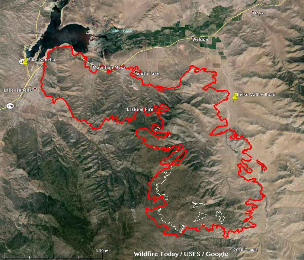
Our very unofficial estimate using satellite data concludes that the fire had grown to well over 12,000 acres by Friday at 2:26 a.m. (see the map above).
This same data shows that the fire spread from just east of the town of Lake Isabella, north to Highway 178 in some places, and ran 12 miles east to within a mile of Kelso Valley Road.
Tyler Townsend, a PIO for Kern County Fire Department, said three firefighters suffered smoke inhalation injuries and were transported to a hospital.
Highway 178 is closed. Thursday night there were 350 personnel working on the fire. That number is expected to grow to 600 to 700 on Friday.
Areas under evacuation orders include 1,500 residences in Bella Vista, South Fork, Weldon, Onyx, Lakeland Estates, Mountain Mesa, South Lake, Squirrel Valley, and Yankee Canyon. The primary evacuation shelter is Kernville Elementary School.
A Type 1 Incident Management Team was ordered just a few hours after the fire started at about 4 p.m. on Thursday.
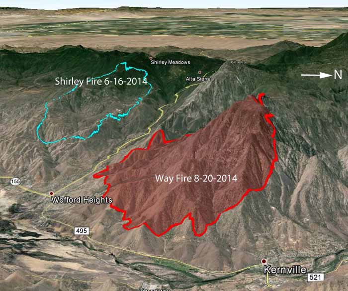
In 2014 two fires burned northwest of Lake Isabella near Highway 155 (Evans Road), the 2,600-acre Shirley Fire and the 4,000-acre Way Fire.


****
(Originally published at 8:07 p.m. PDT June 23, 2016)
The Erskine Fire in Kern County, California started about four hours ago and according to reports from Kern County Fire Department has already burned 50 to 60 structures and 2,500 acres and induced an order for a Type 1 Incident Management Team.
Evacuations are occurring at a hospital and residential areas.
As we are writing this, Kern County Fire Department is broadcasting live video on Facebook. A public information officer for the Fire Department is driving on streets where multiple residences are on fire and narrating as the impressive scenes roll past. At 8:30 p.m. he said “We are estimating 50 to 60 homes lost, but I believe it is well beyond that now.” The video will probably come and go, but you can check at their Facebook page for more.


The fire is about 30 miles northeast of Bakersfield, south of Isabella Lake, east of the community of Lake Isabella, south of Highway 178, and north of Erskine Creek Road.
We will update this article as more information become available.


