(Information about the Way Fire that started August 18, 2014 north of Highway 155 near Wofford Heights and Kernville, can be found HERE. The article below is about the Shirley Fire, of June, 2014))
***********
(UPDATE at 8:47 a.m. PT, June 17, 2014)
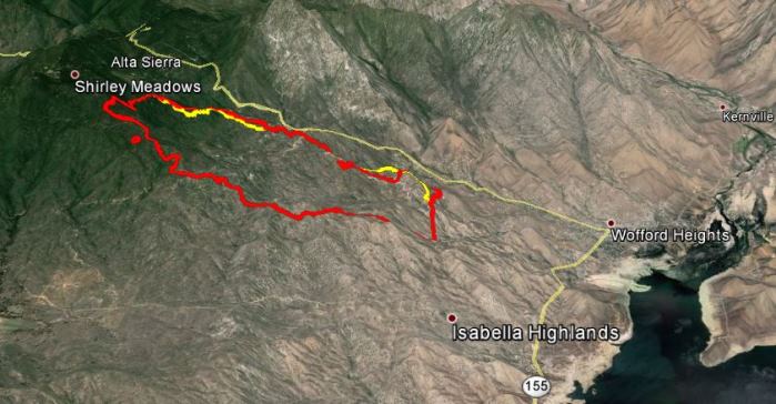
Below is an update on the Shirley fire near Wofford Heights, California, provided by the Incident Management Team at about 8:30 a.m. PT Tuesday:
Excellent progress made over the previous 24 hours on all areas of the fire perimeter has enabled firefighters to raise containment to 75%. Burning operations used yesterday to widen lines in Division Y, held throughout the night. A wind advisory issued for the Kern Valley and will remain in place until Tuesday afternoon, wind speeds are expected to reach up to 45 MPH. Crews will be cautious of the possibility of blowing embers causing spot fires outside the line as they work to improve containment. Safety remains a concern as steep rocky terrain, tree snags and rolling material from the fire are in all areas of the fire. Last nights community meeting was attended by approximately 120 people and was streamed live to another 1100 viewers and can be seen at https://www.youtube.com/watch?v=Bf4hf0WRj8g
Today, crews will continue to hold and improve containment lines and mop up interior to the perimeter. Demobilization of resources will begin today as firefighters return home to prepare and train for the additional wildland fires to come.
The official size is 2,646 acres.
****
(UPDATE at 9 p.m. PT, June 16, 2014)
A community meeting for the Shirley Fire was broadcast live on YouTube Monday night. It started at 7 p.m., and got off to a slow start with a long speech from the Kern County Fire Chief.
Incident Commander Jeanne Pincha-Tulley came on and said they have a line around the entire fire but they are not calling it contained yet.
They said the fire has burned 2,646 acres. The Incident Management Team is calling it 75 percent contained. All evacuations for the fire have been lifted.
Incident Commander Pincha-Tulley in attempting to answer a question about where the three homes that burned were located, said she knew the general area where the losses occurred, but not being from the area, she did not know how to describe the general location to the audience. She said she was not being flippant.
Broadcasting the community meeting live on YouTube was a great idea, at least in concept. On our end, there were quite a few interruptions in the video with a lot of stopping and buffering, while we watched the circle of dots go around and around. Viewers could leave live comments on the website, and many others confirmed that they too were affected by the interruptions in the video.
It was odd that there was no organized attempt to provide a general briefing to the community members about the status of the fire. After they opened it up to questions, one of them, about 30 or 40 minutes into the meeting, was how many acres had burned and how much of the fire was contained. And no one was prepared to answer a question from the audience of where the three burned homes were located.
There may be a recording of the video available later on YouTube, and hopefully it won’t have all of the buffering interruptions. If so we will add the link to it here.
UPDATE at 9:20 p.m. PT, June 16, 2014: A recording of the meeting can be seen on YouTube. In the video, the meeting actually starts at about 48:30. After preliminary information from the host and the Kern County Fire Chief, the meat of the meeting begins at 1:02:33 when the local USFS District Ranger makes a brief comment just before the Incident Commander comes on.
****
(UPDATE at 7:42 a.m. PT, June 16, 2014)
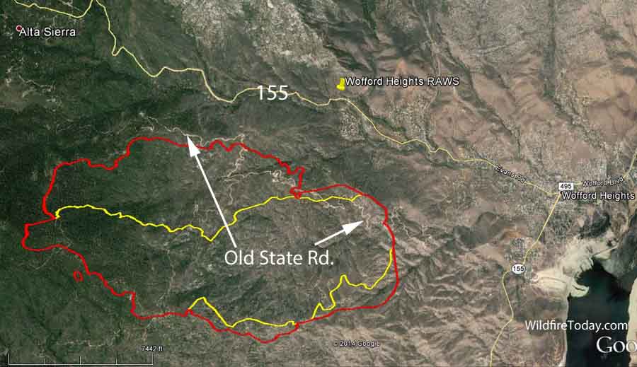
The Shirley Fire west of Wofford Heights was very active on Sunday, growing by over 1,000 acres primarily on the north side but it also expanded on the southeast side. This brings the total area burned to 2,600 acres according to the map and information we have received, but the Pincha-Tulley Type 1 Incident Management Team reported at 8 a.m. Monday that the fire had only burned 2,200 acres. They are calling it 10 percent contained. New information from the Team has been rather sparse, but the National Interagency Fire Center reports that two structures have been destroyed. It is unknown if they were residences or outbuildings.
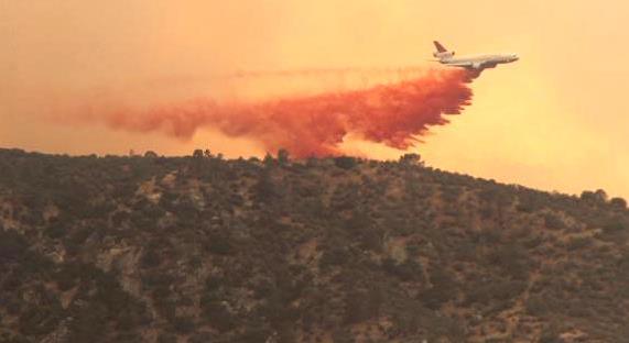
The fire is being fought by 1,176 personnel, with 73 engines, 4 helicopters, and 29 crews at a cost so far of $4.2 million. Air tankers, including one of the DC-10s flying out of Santa Maria, also were busy over the fire on Sunday. Night-flying helicopters from the Kern County Fire Department have also been used after sunset when the other aircraft are grounded.
As the fire spreads to the east it moves from conifers above 5,000 feet to lighter vegetation below 4,000 feet. In the lower elevations the fuels transition to brush and grass, conditions under which the air tankers and helicopters working with the firefighters on the ground can be more effective.
On Sunday the firefighters were faced with winds gusting up to 27 mph. The forecast for Monday is somewhat better, but not great, calling for 5 to 9 mph winds out of the west in the morning, becoming stronger by late afternoon at 15 mph gusting to 21 from the west and northwest.
This photo was sent to us by one of our viewers, Brian Adams, from Wofford Heights overlooking the #ShirleyFire pic.twitter.com/LiO6iqA1Rc
— KBAK/KBFX TV (@bakersfieldnow) June 16, 2014
One of the structures lost in the #ShirleyFire. Locals tell us nobody lived here. pic.twitter.com/OVJUii3ZKY — Clayton Sandell (@Clayton_Sandell) June 16, 2014
The cameraman in the above photo is wearing an interesting combination of clothing — what appears to be a fire resistant Nomex shirt or jacket, and shorts.
****
(UPDATE at 4:37 p.m. PT, June 15, 2014)

The Shirley Fire southwest of Kernville and west of Wofford Heights, California was very active Sunday afternoon, pushed by west and west-northwest winds gusting up to 26 mph. Below is an update from the Kern County Fire Department at 1:30 p.m.:
Night operations with helicopters continued through last night. The VLAT, very large air tanker, is in use this afternoon as well as other air assets. Last night, in cooperation with fire operations, the Kern County Sheriff’s Office initiated evacuations in the following areas: Pala Ranches, Juniper Highlands, Old State Road, all residences between Old State Rd and Evans Rd on Hwy 155. An evacuation advisory was also issued for Alta Sierra 500 residences fall within the evacuation area.
Smoke plume from the #ShirleyFire as seen from Wofford Heights, CA. pic.twitter.com/MxwUoRxeuM — Clayton Sandell (@Clayton_Sandell) June 15, 2014
****
(UPDATE at 1:56 p.m. PT, June 15, 2014)

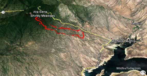
The map of the Shirley Fire southwest of Kernville and west of Wofford Heights, California shows that at 10 p.m. Saturday night it had burned 1,600 acres. The Incident Management Team said it was 1,800 acres and 10 percent contained at 11:30 a.m. Sunday. Kern County Fire Department announced at midnight, very early Sunday morning that areas being evacuated include Old State Road to Evans Road and Alta Sierra to Rancheria Road. The Kern County Red Cross and Kern County Human Services has opened a shelter at the Lake Isabella Senior Center – 6405 Lake Isabella Blvd. in Lake Isabella. There will be representatives from Kern County Animal Control present to assist families with small and large pets and animals. Kern County Fire Department helicopters 407 and 408 are making water drops at night to protect structures and support ground crews. On Sunday firefighters will be battling strong 16 mph northwest winds gusting up to 24 according to a forecast, with a temperature of 82 degrees, and a relative humidity in the lower teens. Between 11 a.m. and 1 p.m. the wind was from the west at 12 to 14 mph with gusts up to 24.

#ShirleyFire right now. pic.twitter.com/cQqAN1iklm — Phil Hernandez (@AGCaptain) June 15, 2014
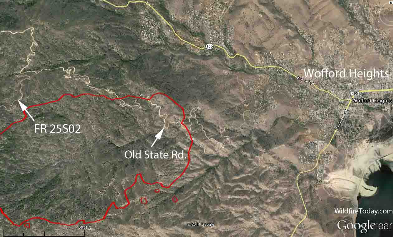
Below is a 3-D map of the perimeter of the Shirley Fire at 10 p.m. June 14, 2014.
****
(UPDATE at 10:20 p.m. PT, June 14, 2014)
The Incident Management Team distributed the following information at about 8:40 p.m. Saturday:
The Shirley Fire has grown to 810 acres and is at 5% containment. The fire is currently the most active in the Rattlesnake Creek area, about 1 mile southwest of Wofford Heights. Flames are visible from Wofford Heights and several calls have been received from concerned residents. It is important to note that there are currently no evacuations in the area of Wofford Heights. This being the case, preparedness should always be a priority when living in the wild land interface and residents are encouraged to be prepared in the event that evacuation should become necessary. If this happens, residents living in the affected area will be notified via Reverse 911 by the Kern County Office of Emergency Services. Smoke will continue to be an issue in the area and residents who may suffer adverse health effects due to smoke are encouraged check with your health care provider.
Jeanne Pincha-Tulley’s Type 1 Incident Management Team assumed command of the fire at 6 p.m on Saturday.
Wow! #ShirleyFire RT @SoCalHazy: From my Moms house in Wofford Heights @Elaina23ABC pic.twitter.com/gNtrugv5Qx @23ABCNews — Elaina Rusk (@Elaina23ABC) June 15, 2014
****
(UPDATED at 6:37 p.m. PT, June 14, 2014)
**** (UPDATED at 3:30 p.m. PT, June 14, 2014) Advisory or precautionary notices of evacuation have been issued for some areas near the Shirley Fire near Lake Isabella, California. It is not yet an actual order to evacuate.
Precautionary notices of evacuation have been put in for the areas of: Alta Sierra, Isbella Heights, Old State… http://t.co/iS3pswbfPh — Kern County Fire (@kerncountyfire) June 14, 2014
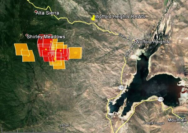
Below is an updated map of the Shirley Fire, showing heat detected by a satellite at 2:39 p.m. PT, June 14, 2014.
#ShirleyFire #WoffordHeights warmer but far less windy than yesterday. http://t.co/M7FgGPyhEA #SequoiaNationalForest pic.twitter.com/GV7g6foMjC — Justin Sacher (@justinsacher) June 14, 2014
****
(Originally published at 8:56 a.m. PT, June 14, 2014; updated at 1:14 p.m. June 14, 2014))
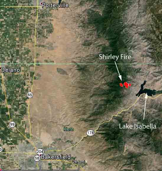
A Type 1 Incident Management Team has been ordered for the Shirley Fire which started late Friday afternoon on the Sequoia National Forest about 5 miles northwest of Lake Isabella in California, 2 miles south of the community of Alta Sierra. Jeanne Pincha-Tulley’s team will inbrief at 1 p.m. on Saturday. Last August the same team was on the Shirley Complex which was also on the Sequoia NF.
Kern County Fire Department announced at 1 p.m. that the fire has burned 500 acres. There was an unconfirmed report on Twitter at about 1:30 p.m. that the fire activity had increased substantially and air attack ordered a Very Large Air Tanker (T-910) and six medium air tankers.
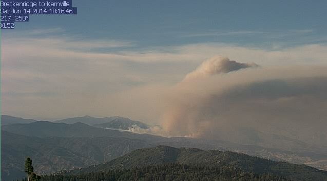
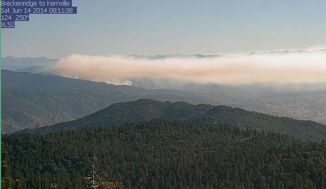
The fire can be seen from the Breckenridge #3 web camera. Another web camera is at Wofford Heights.
In the hours after the fire started, the Wofford Heights weather station two miles northeast of the fire recorded winds gusting up to 21 to 25 mph with a low relative humidity that afternoon of 16 percent. The Saturday forecast for an area 1,000 feet lower than the fire calls for a high temperature around 80, relative humidity of 10 percent, and calmer winds out of the south and later the west at 6 to 8 mph.
We will update this article as more information is available.

Is there a evacuation order for
wofford Heights? Areas around Calgery Drive? Or Black Canyon Trail?
Susan, this article is about the Shirley Fire in June. Information about the current fire, the Way Fire, is HERE.
Coming up to camp this thursday to Headquarters is campground still open and is fire heading that direction or away from the Kernville area ?
Sharon, I am not familiar with that campground, but the firefighters have stopped the spread of the fire… at least for now.
Is the fire near Bodfish?
Just had the opportunity to watch the Shirley Fire community meeting live-streamed on YouTube. Really a great resource. I hope this becomes commonplace with all large incidents.
I’m in pala ranches at the back of the community on the BLM National Forest boundary.they straydoll holding the fire line about a half mile to the west of pala ranchesi at the top of the ridge around 4700 feet…i am at 4000. They are doing a good job up there because it hasn’t come down the hill as iong as the wind doesn’t pick up. They cut a bulldozer fireline in back of the ranches community on the National Forest line so that should help a little bit no prob make the final stand there if it does
The Lions Trail is a loooong ways from this. Hwy 155 over Greenhorn Summit, down Evans Grade to Wofford Heights is closed. Hwy 155 from Wofford Heights to the town of Lake Isabella where it connects with Hwy 178 is open at this time.
Lived in Tehachapi during late 50’s to mid 60’s and used to take Caliente-Bodfish road to go fish at Isabella…wondering if “Lions Trail” is still open and in what condition its in…..
Yes the lion’s trail is still actively in use and well maintained.
T-48 working this fire had a incident upon landing last night. Crew is ok. Aircraft is heavily damaged.
Was this at Porterville or Fox? We watched them fly Sat. out of PTV along with T-44, T-01, and 2 Cal Fire S-2’s.
More info here:
Air Tanker 48 lands on collapsed landing gear at Fresno
If the fire runs down to Kernville and it’s not out, what direction will it travel. Will it travel North along the Kern River, any chance it will reach Johnsondale Bridge?
How close is the fire to Alta Sierra? We have relatives that own a cabin up there. Is Alta Sierra being evacuated?
Thanks
My grandparents have a cabin in Alta Sierra. They were under voluntary evacuation orders yesterday. They left due to smoke more than anything else. However if you leave they are not letting anyone back up 155 until it is a clear.
Does anybody know if the fire reached the pinebrook community in Wofford heights?
Weatherunderground seems to keep their firemap pretty well updated. All of you looking for specific areas can zoom in for your locale, and if you enable “active fires” you’ll see the most current boundaries.
http://www.wunderground.com/wundermap/?lat=38.886&lon=-104.948&zoom=13
PS. the WU map has a search feature, so you can search, for example, for wagy flat and the marker shows where it is in relation to the fire. You can see by the grey-to-black smoke plume indicator which way the wind is blowing.
Concerned about Paul and Megan Zelanka in Wofford Heights. If you know them please tell them we are thinking of them and hoping everyone of Wofford Heights are ok.
From the fire talk, I have heard that the fire will make it to Kernville. It is located in a steep area and it is pushing downhill hard tonight. It is now only 5% contained.
How far is Mountain Shadow Road from the fire.?
Great coverage. What’s the source of your Google Earth Fire perimeter data?
Do you know if the fire has reached Sawmill Road yet? And if so, has it reached Wagy Flat?
As of this morning it has not got to Wagy Flat yet. Is close though. I have property up there and my cousin lives up in Lake Isabella and know the area very well. She has been keeping me posted. If winds don’t change Wagy should be ok.
How close is the fire to the ELKS Lodge
The fire is 2 miles away from the Elks Lodge at 6708 Wofford Blvd, Wofford Heights, CA 93285.
Stay Safe Fire Family…You are all HEROES no matter the Uniform! Slay the Dragon!
Does anyone know Adela Brown of Wofford Heights. I can’t find if she had to leave or what.
I haven’t looked at the fire in awhile, but around noon it looked like 4 federal, 2 state, and 1 VLAT airtankers… along with multiple type 1 and type 2 helos assigned.
Wow Bill,
I live in Alta Sierra full time and the information your giving is great.
Thank you
Mark
@890 acres currently at 8:15pm PST
bit.ly/1nEgyZS