Evacuations ordered for Horseshoe 2 fire in Arizona

Map of Horseshoe 2 fire 0930 6-3-1011

Updated at 3:15 p.m. June 3, 2011

Map of Horseshoe 2 fire 0930 6-3-1011
Map of Horseshoe 2 fire, showing heat detected by satellites within the last 24 hours. An earlier perimeter, mapped at 7:31 p.m. 6-1-2011, is in red. Heat was mapped sometime prior to 0930 MT 6-3-2011. The AZ/NM state line is the faint white line just west of Rodeo, NM. MODIS/Google

As you can see from the map of the Horseshoe 2 fire above, the fire has grown significantly over the last two days and is now close to the community of Paradise. It is burning in the southeast corner of Arizona near the New Mexico state line. More information is at InciWeb. The incident management team produced this fire progression map from data collected Thursday night.

The weather forecast for Paradise, AZ, (elevation 5,599′) calls for 22 mph winds gusting up to 31, high temperature of 87, and a low relative humidity of 6% Friday afternoon…not good news for firefighters. Current near-real-time weather observations can be found at the site for the Monte Vista RAWS weather station located on the west side of the fire at an elevation of 9,250′. At 2:06 p.m. on Friday it recorded a temperature of 70 degrees, 12% humidity, and a 17 mph wind gusting up to 30.

Jim Thomas’ Incident Management Team has been ordered for June 4 to replace Dugger Hughes’ IMTeam which will conclude their 14-day assignment. More about these IMTeams.

The Incident Management Team distributed the information below at 9:00 Friday morning:

===========================

“Evacuation ordered for Paradise and East Whitetail Canyon

The Cochise County Sheriff’s office has issued a mandatory evacuation order for the communities of Paradise, East Whitetail Canyon and the surrounding communities effective 6:00 pm, June 2, 2011.
Fire Facts:

  • Date Started: 05/08/2011
  • Number of Personnel: 825 personnel including 9  hotshot crews, 9 hand crews
  • Location: 5 miles south of Portal, Arizona
  • Cause: Human – under investigation
  • Equipment: 36 Engines, 24 Water Tenders
  • Size:  86,140 acres
  • Estimated Containment Date: 06/22/2011

General Information/Announcements:

A Red Flag Warning is in effect today from 12:00 to 8:00 p.m. due to high winds. Despite the concentrated effort of over one hundred hotshot firefighters, yesterday the fire crossed Rock Creek Canyon and, aided by strong winds and high flame lengths, the fire spotted over a mile and a half east towards Paradise. The Barfoot Lookout Tower and communication equipment in the area were destroyed by the fire, and crews were forced to disengage and shift to an indirect firefighting strategy.

According to Incident Commander Dugger Hughes, a dead oak tree burning within the main fire area threw an ember over containment lines, which landed into a live oak tree with a dead branch. Over the course of the night, the ember came to life and by the time firefighting resources were able to detect it early the next morning the fire had reached unsafe conditions.  The oak tree was not lit as part of a burnout operation.

“This goes to show that you can work hard and do everything right, and all it takes is one little ember in the wrong place at the wrong time,” said Hughes.”

=============

Update: read the June 4, 2011 article about the Horseshoe 2 fire.

Horseshoe 2 fire becomes 5th largest wildfire in Arizona history

Horseshoe Two fire from Earth orbit

Updated at 8:36 p.m. MT, June 2, 2011

The Incident Management Team issued the following update this evening:

Evacuation Order for

Paradise and East Whitetail Canyon

For immediate release: June 2, 2011 at 6:30 p.m.

The Cochise County Sheriff’s office has issued a mandatory evacuation order for the communities of Paradise and East Whitetail Canyon as of 6:00 pm, June 2, 2011. The evacuation is being issued as a safety precaution. Due to Red Flag wind conditions, The Horseshoe 2 Fire has extended across Rock Creek Canyon and has moved northeast. The fire has spotted across Pinery Canyon Road (Rte. 42) and firefighters are actively working to suppress that fire.

The Chiricahua National Monument is temporarily closed to visitors.

More information is at InciWeb.


Horseshoe Two fire from Earth orbit
Horseshoe 2 fire as seen from the International Space Station. NASA photo.

The Horseshoe 2 fire, which started on May 8, grew by a couple of thousand acres each day during most of the month of May, but after May 26 when it was 47,000 acres it began eating up the acres at a faster rate until today it reached 80,500 acres and became the 5th largest fire in the recorded history of Arizona.

Horseshoe 2 fire, burning out
Three hotshot ignition specialists evenly spaced walk in a line lighting the grasses, providing for a low intensity controlled burn to clear understory. Photo: Todd Abel SWIMT

Here is an excerpt from today’s 9:00 a.m. update by the Incident Management Team:

The primary focus of today’s activities will be to contain the fire that crossed the line in Saulsbury Saddle, which includes constructing hand line by five hot shot crews and dropping retardant from aerial resources. Structure protection is in place in the West Turkey Creek area as crews have taken precautionary measures to minimize the threat of property loss.

Burnout operations will continue on the southwest side of the fire along Tex Canyon Road, completing the remaining six mile containment line for that area.

Smoke will be visible over the northwest and southern portions of the fire as operations continue. Travelers along State Route 80 will continue to see fire activity and are asked to be extra careful while driving in this area.

Map of Horseshoe 2 fire 0945 6-2-1011
Map of Horseshoe 2 fire, showing heat detected by satellites. The perimeter, mapped 6-1-2011, is in red. Heat was mapped sometime prior to 0945 MT 6-2-2011. MODIS/Google

More information about the Horseshoe 2 fire, which is on the Arizona and New Mexico border near Portal, AZ and 2 miles west of Rodeo, NM, is at InciWeb.

=============

Update: read the June 4, 2011 article about the Horseshoe 2 fire.

Schultz fire, one day too early

In June the Schultz fire, started by an abandoned campfire, burned 15,000 acres north of Flagstaff, Arizona. As far as I know, the culprits have not yet been found but there was a reward offered by a local brewery of free beer for life for anyone with information leading to the campers who left the fire burning.

At a public meeting this week the Forest Supervisor of the Coconino National Forest discussed the fire restrictions which were not in place when the fire started. Here is an excerpt from the Arizona Daily Sun:

One question prompted the most audience applause Wednesday night at Coconino High: Why weren’t any fire restrictions in place before the fire began?

The Schultz Fire began this past summer after other major wildfires had already prompted evacuations, including the Hardy Fire and a fire in Spring Valley.

Coconino National Forest Supervisor Earl Stewart responded:

“Trying to come up with criterion as to when it’s best to close the forest is really, really difficult,” he said.

The agency has not opted to use certain dates of the year to set or remove fire restrictions, because sometimes those dates don’t match what’s been happening with the weather, he said.

Also, Stewart doesn’t want to close the forest to public access when it isn’t necessary, he said.

The Coconino tries to match its fire-restriction decisions to three other forests so that the public isn’t confused about what the rules are in various places, he said.

The decisions about whether to implement fire restrictions across these forests are made in Monday-morning phone calls during the spring and summer.

The Schultz fire started on a Sunday after a Saturday wildfire forced the evacuation of parts of southeast Flagstaff.

So it occurred before the Monday meeting used to discuss fire restrictions or closures.

“The reality was, in this case, the Schultz fire was 24 hours too early,” Stewart said. “We had not gotten into those discussions.”

Turn in Schultz fire suspects, get free beer for life

Yep, that is what someone posted on the Flagstaff Brewing Company’s Twitter account:

free beer for life 2 whoever turns in the schultz campers w/ the 5 foot campfire @ 930 am on sunday. Our peaks mean more than $ & words.
about 14 hours ago [about 11:30 pm June 24] via Twitter for iPhone

We talked to Jeff Thorsett of Flagstaff Brewing Company to see if it was really true. The company sells their beer in 1/2 gallon containers, and he said if a tip results in the arrest and conviction of the person who started the fire, they will give the tipster 1/2 gallon of beer each week for the rest of their lives. Now THAT’S a REWARD!

Investigators have determined that the Schultz fire started from an abandoned campfire on June 20 at Schultz Tank and Elden Trail north of Flagstaff, AZ. In addition to “free beer for life” from the brewing company, the U.S. Forest Service is offering a more conventional $2,500 reward. USFS officials request that anyone having information concerning the abandoned campfire call the Coconino NF Supervisors’ Office at (928) 527-3508.

Description of the Schultz fire’s ICP

It can be enlightning to see wildland firefighting described through the eyes of someone else. The Arizona Daily Sun has an article describing the Incident Command Post at the 14,800-acre Schultz fire north of Flagstaff, Arizona which burned about 5,000 acres in the first 8 hours. It is a well written story and is worth reading, but I could not help but notice two minor errors in this excerpt. Can you find them?

When the Schultz fire exploded into a raging wildfire Sunday afternoon and garnered the highest level of firefighting priority in the nation, hundreds of firefighters rushed to northern Arizona to battle the fast-moving blaze.

Behind that initial attack, and in just a matter of 24 hours, a mini-city of support assembled at Cromer Elementary School.

Welcome to ICC, or incident command center, where firefighters can eat scrambled eggs with green chili, reload on sunscreen and bug repellent, get a medical checkup, take a shower and shave, fill up on cookies and ice cream, check out the fire-tracking maps and then find a cot to crash on.

The command center serves as a base camp for the personnel — more than 950 strong (including up to 800 firefighters) — assigned to the Schultz fire. That total includes “overhead” or supervisory workers who support the firefighting effort mostly from the ground.

“There’s a tremendous amount of infrastructure to put in place,” said Troy Waskey, who is on staff with recreation, lands and minerals at the Tonto National Forest. “That’s the beauty of the ICC structure: You can put a team in place with the resources that are needed within 24 hours.”

AN ACTION PLAN

Run as tightly as a military operation, the world of wildfire fighting is full of acronyms and abbreviations, specific uniform requirements, and lots of rules and orders, many spelled out daily in the IAP, or incident action plan, passed out in booklet form to all concerned personnel during the morning briefing.

Webcams for Schultz the fire near Flagstaff

Dinos sent us some links to web cams, some of which show the Schultz fire, which has burned 14,000 acres north of Flagstaff near the San Francisco Peaks.

http://24.121.15.116/
http://jan.ucc.nau.edu/~wal2/webcams.htm

More information about the Schultz fire can be found at InciWeb.

Thanks Dinos

Arizona: Fuels and fire behavior advisory

Posted at the Southwest Coordination Center web site:

Subject: Heavy Fine Fuel Loads Have Created the Potential for More Active Fire Behavior

Discussion: Above-average rains during the summers of 2006 and 2007 have created heavier than normal fine fuel loads in southern Arizona, especially in desert areas infested with Buffelgrass (Pennisetum ciliare).

Many grassland areas in southeastern Arizona (above 3,500’) have had above average precipitation the past two summers, creating a heavy crop of grass. Historically, this situation has been followed by a year with large fires.

In addition, buffelgrass continues to increase in desert areas. Buffelgrass is a noxious, non-native grass that is roughly doubling each year in Pima County. Fuel loads can be 5-20 times greater than annual grasses like red brome. Because it is increasing so rapidly, firefighters may find thick grass in places that traditionally had little. Because the fuel load is so heavy, it can generate fireline intensity and flame length much more extreme than usual for the desert. Strategies and tactics normally used on desert fires may not succeed on buffelgrass fires.

Common denominators of tragedy fires are potentially present in deserts and grasslands: relatively small fires or deceptively quiet areas of large fires; relatively light fuels, such as grass, herbs, and light brush; unexpected shift in wind direction or in wind speed; fire responds to topographic conditions and runs uphill.

Concerns to Firefighters and the Public:

• Flame length in grass can exceed 4 feet at almost any time of year, exceeding capability of hand tools. Flame lengths can exceed 8 feet during fire season, exceeding the capability of light engines.

• Grass fuels can be continuous, creating wide flaming fronts.

• Greater fireline intensity can lead to increased torching of shrubs and increased spot fires.

• Anticipate fire whirls because of a combination of fuel loading, terrain, and unstable atmosphere.

• Heavier fuel load raises moisture of extinction, and active burning may occur throughout the night.

• Normally bare, rocky areas and steep, south-facing slopes may have enough grass to carry a fire.

• Washes and trails that formerly served as fuel breaks may no longer be effective.

• Retardant may be less effective at stopping fires where grass is thick.

• Greater fireline intensity and flame length increase threat to structures, power poles, and other improvements.

• Some Wildland Urban Interface areas are infested with buffelgrass. Increased fire behavior increases risk to structures, improvements, and public safety, and there is potential for more human-caused fires.

• Increased fuel loading increases radiant heat output, therefore increasing the risk of thermal burns.

• The outlook for April-June is for above average temperatures and below average rainfall, exacerbating the problem.

Mitigation Measures:

• Indirect tactics may have to be used more often.

• Maintain situational awareness of fuel conditions and fire behavior.

• Safety zone size may need to be larger than usual for the desert. Safety zones may be harder to find.

• Use of Nomex face shrouds helps protect the face and airways.

Area of Concern: Desert


Fires in CA and AZ

Santa Anita fire near Sierra Madre, California:
It is now 584 acres and is 88% contained. All of the mandatory evacuation orders have been lifted. Here is an interesting quote from the Sierra Madre mayor:

“Early this morning the flames had raced to within a couple feet of our homes in the canyon and those brave firefighters … formed a perimeter with their bodies and their fire engines. It was a barricade of steel and water and human flesh and blood and they stopped the fire dead in its tracks.”

Just to be clear, there has been very little, if any, blood shed on the fire. They are reporting four minor injuries.


X fire:
This fire is just south of Grand Canyon National Park in Arizona. It started at noon yesterday, Tuesday, and quickly grew to 2,000 acres. The name of the fire came from the nearby Ten-X campground. The name alone makes this fire interesting.

Local media is reporting that it started from a campfire and that two individuals are being questioned. There is a red flag warning today for winds at 15-20 with gusts up to 40, and an 8% relative humidity. These southwest winds could push the fire into the national park. Reinarz’s Type 2 Incident Management Team should arrive today.

Click on the map of the X fire below to see a larger version. The map shows heat detected last night (the red and orange areas) by satellites. The green area on the map is the Kaibab National Forest, and the gray area north of the fire is Grand Canyon National Park.

Fire simulator training in Prescott, AZ

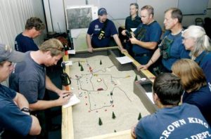
Prescott fire training

Fire simulators can provide a very valuable opportunity to test and improve your firefighting skills. On the Cleveland National Forest we used to use four overhead projectors to produce images of the landscape, smoke, and fire on a rear projection screen, two 4-track reel-to-reel tape recorders and a mixing board for sound effects, and up to 10 people to run the simulation and act as role players. I have not seen the new computer-based simulator that is being used this year, but I hope it is at least as realistic as the earlier systems.

The Daily Courier in Prescot, AZ has a story about firefighters going through an exercise using a simulator and sand table.

Here is an excerpt:

Well aware that numerous agencies often come together suddenly to battle dangerous wildfires, Prescott-area agencies gather each year to brush up their skills before the traditional wildfire season begins.

Prescott fire training
“Firefighters from a variety of agencies look over a sand table model to plan their next action steps for the 1,200 acre fire they were responding to as part of the annual Basin Drill at the Prescott Fire Center. Photo courtesy of The Daily Courier, Les Stukenberg

“We’re testing ourselves to a level we’ve never tested before,” Prescott Fire Chief Darrel Willis said as he surveyed more than 50 people in the incident command center room alone. “Look at all the agencies here. There’s a comfort level when you see people you know. We know what we can expect from those people.”

Such training can save the lives of firefighters as well as citizens who live in wildfire-prone areas of the Prescott region.

“Communications are always going to be difficult,” Bentley said, so training helps immensely with smoothing out radio compatibility issues. Firefighters also learned some lessons about setting up an incident command system quickly so the span of control is clear, he said.

The sand tables are literally that – wooden tables covered with sand that firefighters mold to mimic the actual fire terrain. They add miniature trees, homes and fire trucks to the scene. They move red strings and cotton balls forward to represent an advancing wall of fire.

The Forest Service started making its computer simulator widely available just this year, Bentley said.

Fire instructors input U.S. Geological Survey computerized topographical maps into the simulator, then add as many as 20 types of homes along with local vegetation, roads, streams and even propane tanks.”


Scottsdale, 2-day exercise, 25 fire agencies

KPHO.com has the story:

SCOTTSDALE, Ariz. — More than 25 statewide fire agencies, fearing an active wildfire season, are taking part in a major training exercise at McDowell Mountain Regional Park in Scottsdale.

They are learning how to work together to protect the land, homes and lives when the brush fire season starts in mid-April.

Firefighters said they believe that the aggressive growth of desert grasses triggered by soaking winter rains will spell danger once the vegetation dries out in hotter weather.

“We’re expecting a pretty active desert fire season,” said Mike Guardado, one of the firefighters involving in the training. “We’re getting to know each other and getting to know each other’s equipment.”

Guardado spent four years fighting fires for the U.S. Forest Service. He said he knows the dangers and difficulties when flames meet dry brush.

“It’s pretty challenging,” he said. “It can be frightening at times, especially working with hand tools when there’s no water around.”

While crews are training to protect homes and land, they’re also learning to protect themselves.

Last year, crews across the state battled 1,926 wildfires devouring 63,908 acres, according to the Arizona State Forestry Division. That was a dramatic decrease from the 3,080 wildfires seen in 2006 that burned more than 152,000 acres.

The two-day training event, which ends Thursday, is an effort by the Scottsdale Fire Department and the Central Arizona Wildland Response Team.

The team is a consortium of approximately 15 fire agencies in central Arizona that participate in state and nationwide wildland fire response.