Forest Service Chief calls for treating two to four times more hazardous fuels acres

Forest Service Chief Vicki Christiansen
Forest Service Chief Vicki Christiansen testified before the Senate Committee on Energy and Natural Resources June 17, 2021. (Still image from the Committee video.)

In what will be one of her last appearances in a Congressional hearing before she retires at the end of August, U.S. Forest Service Chief Vicki Christiansen called repeatedly for a “paradigm shift” for treating hazardous fuels.

Today she testified before the Senate Committee on Energy and Natural Resources to defend the President’s budget request for the U.S. Forest Service for Fiscal Year 2022 which begins October 1.

In addition to increasing the amount of timber harvested on Forest Service lands, the topic of reducing the number of devastating wildfires came up many times in the hour and a half hearing. A video is available on the Committee’s website.

Senator John Barrasso (WY) mentioned (at 27:49 in the video) that in an April hearing the chief said a paradigm shift was needed to reduce the hazard fuels in forests. He asked,  “Do we need to dramatically increase the number of [wildfire mitigation] acres treated annually?” Chief Christiansen said,”Yes… We can’t just do the same old thing we’ve always done, just treat whatever acres we can get to… We have a crisis. We have a crisis that needs to be addressed differently.”

The Chief said the agency treats about three million acres each year, but they need to treat two to four times that amount.

Senator Ron Wyden (OR) got the Chief to confirm that the agency’s latest estimate is that it would take $20 billion over a 10-year period  to “get in front of the hazardous fuel challenge” (at 39:25).

The National Wildfire Coordinating Group created a wildland fire glossary of terms, which includes their definition of “hazard fuels”:

A fuel complex defined by kind, arrangement, volume, condition, and location that presents a threat of ignition and resistance to control.

Senator Wyden addressed the possibility of a fire season this year that could be worse than average (at 36:40). He asked, “What is the plan for keeping people safe when there are fires in multiple communities in the West?”

Chief Christiansen said, in part, that in recent years there has been competition for firefighting resources when the number of fires have resulted in requests for firefighters and equipment that were unable to be filled, and later said, “Our system is at a breaking point.”

Senator Wyden asked the Chief to submit a “written statement on what the plans are if we are short on resources in the West.”

Senator Catherine Cortez Masto (NV) asked if the President’s proposed budget includes sufficient funding for battling wildfires, post-fire recovery, prevention, reducing hazard fuels, and addressing invasive species.

“Senator, it’s a step in the right direction. A significant step in the right direction… It helps in modernizing our wildland fire workforce. It does not get us every step that we need to be.

“I’m very concerned about our workforce,” she continued. “They are tired, and fatigued. Their mental well-being and stress that we are concerned about. Many of these folks are temporary employees and they try to make a year’s living in six to nine months. There are still more things to address, but this budget is a very good first step.

Senator Masto asked about the recruitment and retention challenges that the agency is facing (1:05:30).

“It’s a calling to do this work,” the Chief said. “But anybody should be able to have a living wage to do this work. We do have concerns about a competitive wage… We are committed to work with the Department of the Interior and others to do a comprehensive look at our workforce needs.”

“Please share that,” said Senator Masto. “It’s the same thing I’m hearing in my state from our fire chiefs. It’s a challenge. And this is something we have to address.”

Senator Angus King (Maine) said timber sales on public lands fell from 13 billion board feet in 1988 to 3.2 billion last year, a factor of five, he said. (1:13:07) “What in the hell happened,” he asked. Later he said, “Coincidentally from 1991 to 2020 the number of acres burned has gone up by a factor of five. Is there a connection?”

“Yes sir, there is,” the Chief quickly replied. The Senator moved on to another topic and did not allow her to fully explain why she thought there is a connection.

NOAA satellites zoom in on wildfires

By NOAA

Fire weather is heating up across the western United States, exacerbated by an intense heatwave and ongoing severe drought. NOAA satellites are monitoring numerous wildfires and keeping watch on areas primed for ignition. As of June 17, 2021, 33 large fires are currently active, burning more than 400,000 acres in 10 states. More than one million acres have burned across the country so far in 2021.

NOAA satellites zoomed in on several of the major fires burning in the western U.S, including the Telegraph and Mescal Fires in southeastern Arizona, Pack Creek and Bear Fires in Utah, and the Robertson Draw Fire in Montana.

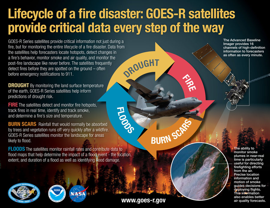
GOES-16 (GOES East) and GOES-17 (GOES West) are monitoring these fires in near-real time. Flying in geostationary orbit, they keep constant watch over the same area, and help to locate fires, detect changes in fire behavior, and predict their motion. They also provide important information about the size, temperature, and intensity of fires that would otherwise be unavailable.

Fire temperature imagery from geostationary satellites is particularly useful to identify new hot spots and the direction those hot spots are moving, especially for fast-growing or newly-formed fires. Specialized imagery that combines data from multiple channels on the satellites’ Advanced Baseline Imager (ABI) instrument, allows both a fire’s hot spot and associated smoke plume to be visualized.

Satellite imagery of several of the fires, including the Pack Creek and Bear Fires in Utah and the Telegraph Fire in Arizona, reveal impressive plumes with thick pyrocumulus clouds, which form when there is enough moisture and atmospheric instability over an intense heat source and smoke.

JPSS satellites feed the HRRR-smoke model, the first weather forecast model in the U.S. to monitor wildfire smoke. The model relies on multiple satellite measurements, such as heat energy, wind speed, rainfall and atmospheric temperature, and combines these data with vegetation maps. The combined data is mapped to a three-dimensional grid that provides information on surface level smoke, and smoke high in the atmosphere. The model also produces a forecast with detailed updates on the height of the smoke plume, the amount of smoke produced and the direction it’s expected to move.

The HRRR-smoke model from June 15, for example, shows smoke from the fires in Arizona and Utah moving north and east across the country.

The benefits provided by the latest generation of NOAA satellites aren’t just seen during a fire but are important in monitoring the entire life cycle of a fire disaster. Data from the satellites are helping forecasters monitor drought conditions, locate hot spots, detect changes in a fire’s behavior, predict a fire’s motion, monitor smoke and air quality, and monitor the post-fire landscape like never before.

Timely satellite imagery is critical, potentially life-saving information in a dynamic fire environment. In the past, incident meteorologists had a single low-resolution image that updated every 15 minutes — typically the image was already 20 minutes old when it arrived at the forecaster. Now, GOES-16 and GOES-17 frequently detect fires before they are spotted on the ground – as early as 10 to 15 minutes before emergency notifications to 911.

Update on Montana fires, Robertson Draw and Deep Creek

1:56 p.m. MDT June 17, 2021

Map of the Robertson Draw Fire
Map of the Robertson Draw Fire. The red line was the perimeter Thursday morning June 17, 2021. The white line was the perimeter about 24 hours before.

Robertson Draw Fire
The fire spread to the north and south Wednesday, but not as much as in previous days. It was mapped overnight at 24,271 acres, a 24-hour increase of about 4,000 acres.

From the Incident Management Team Thursday morning:

“[Wednesday], moderated weather conditions allowed fire crews to work on the northeastern, eastern, and southeastern sides of the fire. Crews and equipment worked to tie in dozer lines to burned areas that had cooled down in the rangeland grass areas. Air tanker water and retardant drops were conducted along the northwest side of Mt. Maurice to check fire spread. Aircraft were also used on the south side to check fire spread. The fire remained active along portions of the northern edge and in the timbered areas south of Mt. Maurice. Additional firefighting crews and equipment arrived and Operations personnel from the incoming [Type 2 Incident Management] team worked closely with the local firefighters to increase their situational awareness and start developing firefighting plans for the next several days.

“Evacuation Orders are in effect for the areas of North and South Grove Creek, Gold Creek, Ruby Creek, and Robertson Draw east to Highway 72. Evacuations as a part of the Forest Closure Order include the USDA Forest Service Recreation Residences in Corral Creek, Spring Creek, Snow Creek, and Sheep Creek.”

To see all articles on Wildfire Today about the Robertson Draw Fire, including the most current, click HERE.

Resources working on the fire Wednesday night included 4 hand crews, 17 engines, and 5 helicopters for a total of 162 personnel. At least 18 structures have been destroyed.

We have a series of photos of the fire taken over a three-day period from the same location. Check them out.

Deep Creek Fire

Map of the Deep Creek Fire
Map of the Deep Creek Fire. The red line was the perimeter Thursday morning June 17, 2021.

The Northern Rockies Type 1 Incident Management Team #1 assumed command of the fire at 6 a.m. Thursday.

The IMT reported Thursday at noon on InciWeb that the fire had burned 3,668 acres, but it is likely that the actual size is about 1,000 acres larger.

To see all articles on Wildfire Today about the Deep Creek Fire, including the most current, click HERE.

The diminished fire intensity Wednesday allowed crews to reengage with a dozer, skidgens, and a hand crew on the southwest section of the fire. The plan for Thursday is to continue direct fire line construction on the southwest corner of the fire moving along the fire’s perimeter to the north while continuing to identify and work on spot fires to the north from Tuesday’s wind event.

The Grassy Mountain subdivision is still under an evacuation order.

Resources working on the fire Wednesday night included 1 hand crew, 6 engines, and 4 helicopters for a total of 94 personnel. There is no report of any structures that have been destroyed.

Fire Aviation reported that a helicopter working on the Deep Creek Fire crashed and burned June 15. There were five on board and all reportedly exited the aircraft before it ignited. They were assisted by a trooper from the Highway Patrol, Amanda Villa who was very close by when the crash, first described by the Montana DNRC as a “hard landing”, occurred. There were injuries, but no details have been released.

Helicopter crash Deep Creek Fire
This Tweet was published the morning of  June 17, 2021.

Robertson Draw Fire — three days of photos

Robertson Draw Fire
Robertson Draw Fire, as seen from the Red Lodge, MT area June 15, 2021. Photo by @MontanaRoots.

These photos of the Robertson Draw Fire were taken from Red Lodge, Montana over a three-day period, June 15 through 17, by @MontanaRoots.

Their Twitter profile:

Montana born & raised, Navy submarine officer vet, MSU Bobcat. Probably out hiking or heading down some backroad. Amateur photographer.

Robertson Draw Fire
Robertson Draw Fire, as seen from the Red Lodge, MT area June 15, 2021. Photo by @MontanaRoots.

To see all articles on Wildfire Today about the Robertson Draw Fire, including the most current, click HERE.

The photos are looking toward Mount Maurice.

Robertson Draw Fire
Robertson Draw Fire, as seen from the Red Lodge, MT area June 16, 2021. Photo by @MontanaRoots.
Robertson Draw Fire
Robertson Draw Fire, as seen from the Red Lodge, MT area June 17, 2021. Photo by @MontanaRoots.

To see all articles on Wildfire Today about the Robertson Draw Fire, including the most current, click HERE.

Smoke forecast for June 16, 2021

wildland smoke forecast wildfire fire
Forecast for vertically integrated smoke at 6 p.m. MDT June 16, 2021. NOAA.

It is only mid-June and we are already looking at large-scale wildland fire smoke issues.

These maps predict the distribution of smoke at 6 p.m. MDT today, June 16, 2021.

Vertically integrated smoke depicts all of the smoke in a vertical column, including smoke high in Earth’s atmosphere and can produce red sunrises and sunsets. In some cases where it is only at high altitudes it may not be very noticeable on the ground.

Near-surface smoke refers to the smoke that will hover within 8 meters (26 feet) of the ground—the kind responsible for burning eyes and aggravated asthma.

wildland smoke forecast wildfire fire
Forecast for near-surface smoke at 6 p.m. MDT June 16, 2021. NOAA.

Helicopter crashes while working on the Deep Creek Fire in Montana

Updated at 11:02 a.m. MDT June 16, 2021

Helicopter crash site montana

The Montana Department of Natural Resources and Conservation said in a tweet that has been deleted the helicopter that crashed Tuesday had a “hard landing”. It was en route to the helibase on the Deep Creek Fire southeast of Helena.

Montana Attorney General Austin Knudsen said it happened right in front of a trooper from the Highway Patrol, Amanda Villa, who helped extricate the people on board.

Helicopter Crash

The most current reports indicate there were five people on board.


8:06 p.m. MDT June 15, 2021

Deep Creek and Robertson Draw Fires
Satellite photo showing the smoke from two wildfires in Montana at 4:11 p.m. MDT June 15, 2021; the Deep Creek and Robertson Draw Fires.

NBC Montana is reporting that a Montana Department of Natural Resources and Conservation helicopter crashed Tuesday while working on the Deep Creek Fire southeast of Helena.

There were injuries among the five people on board, reportedly minor, and were being treated.

Broadwater Reporter has video of what they say is the burning wreckage. They reported that the crew evacuated safely.

The Governor mentioned the crash in a tweet.

The incident occurred on North Fork Road at the intersection of Highway 12.

The Deep Creek Fire is 40 air miles southeast of Helena, burning vigorously east of Townsend on both sides of US 12.

We will update this article as more information becomes available.

MT DNRC helicopter
Helicopter operated by the Montana DNRC. Photo credit: Montana DNRC.

The Montana DNRC operates a fleet of five UH-1H (Huey) helicopters that are on loan from the U.S. Forest Service under the Federal Excess Personal Property program. Three are located in Helena, Missoula and Kalispell to provide direct protection initial attack. The other two are in Helena for state-wide deployment on an as needed basis. They also have access to two light Bell 206 B-III type 3 helicopters stationed in Helena. One is owned by the Department of Environmental Quality (DEQ). DNRC maintains this aircraft and provides pilot services to DEQ. In return, DNRC reserves the right to use it for fire missions. The second light helicopter is used as a backup aircraft or for additional coverage.

Robertson Draw Fire in Southern Montana prompts evacuations

Update at 7:44 p.m. MDT June 15, 2021

satellite photo two wildfires in Montana June 15, 2021
Satellite photo showing the smoke from two wildfires in Montana at 7:41 p.m. MDT June 15, 2021; the Deep Creek and Robertson Draw Fires. The Robertson Draw Fire shows massive growth over the previous three and a half hours. NASA. GOES 16.

The satellite photo taken by GOES 16 at 7:41 p.m. MDT June 15 shows an enormous smoke plume from the Robertson Draw Fire spreading to the northeast. It is heading directly to Billings, the lights from which can be seen through the smoke.

To see all articles on Wildfire Today about the Robertson Draw Fire, including the most recent, click HERE.


5:13 p.m. MDT June 15, 2021

map Robertson Draw Fire
Map showing the location of the Robertson Draw Fire. The red dots represent heat detected by a satellite at 3 a.m. MDT June 15, 2021. The other colors are from earlier satellite overflights.

The Robertson Draw Fire 9 miles south of Red Lodge, Montana is burning vigorously Tuesday afternoon, producing a very large smoke column easily seen on satellite photos.

Tuesday morning firefighters estimated the size at 2,000 acres but that number could be very different by the time the sun sets.

The fire is in south-central Montana one mile north of the MT/WY state line, and five miles east of the famous switchbacks on the Beartooth Highway, US 212.

3-D map Robertson Draw Fire
3-D map showing the APPROXIMATE location of the Robertson Draw Fire, based on satellite heat data at 3:48 a.m. MDT June 15, 2021.

Evacuations and evacuation warnings are in place for multiple areas near the fire. Firefighters expected a critical fire weather day on Tuesday with Red Flag Warnings in effect due to the hot, dry, and windy weather conditions. According to the Type 3 Incident Management Team, the Gold and Ruby Creek areas were re-evacuated Tuesday morning.

The fire ranges from 7,000′ above sea level up to 9,300′.

Robertson Draw Fire
Robertson Draw Fire, June 14, 2021, InciWeb photo.

About 80 firefighters are working to suppress the fire. Resources include hand crews, engines, helicopters, a rappel crew, and support personnel. Air tankers are assisting firefighters as needed and available. A Type 2 Incident Management Team has been ordered.

satellite photo two wildfires in Montana June 15, 2021
Satellite photo showing the smoke from two wildfires in Montana at 4:11 p.m. MDT June 15, 2021; the Deep Creek and Robertson Draw Fires.

Another fire in Montana, the Deep Creek Fire, is 128 miles northwest of the Robertson Draw Fire, and 40 miles southeast of Helena. It is also burning vigorously, east of Townsend on both sides of US 12. This first photo shows what it looked like on June 13.

Deep Creek Fire
Deep Creek Fire, as seen from MM19 on Hwy. 12 near Townsend, MT. Photo by Mike Vinion June 13, 2021.

To see all articles on Wildfire Today about the Deep Creek Fire, including the most current, click HERE.

What do we owe wildland firefighters?

By Jonathon Golden

“It’s like having gasoline out there,” said Brian Steinhardt, forest fire zone manager for Prescott and Coconino national forests in Arizona, in a recent AP story about the increasingly fire-prone West.

Now something else is happening — and at the worst possible time.

Federal firefighters are leaving the workforce and taking their training and experience with them. The inability of federal agencies to offer competitive pay and benefits is creating hundreds of wildland firefighting vacancies.

Vacancies, of course, limit how much federal firefighters can do. If Western communities want to be protected, they need to ensure that their firefighters receive better pay and benefits.

Jonathon Golden
Jonathon Golden

In my 11 years of work as a wildland firefighter, I’ve managed aircraft, trained people and run fires myself, but I also did outreach and recruitment for the Forest Service and Bureau of Land Management. I know how hard it is for hiring managers to make 2,000 hours of grueling work, crammed into six exhausting months, sound appealing when the pay is $13.45/hour. The pay doesn’t come close to matching the true demands or everyday dangers of the job.

Federal wildland firefighters, by necessity, are transient workers. During the fire season — now nearly year-round — they must be available to travel anywhere in the United States at any time. And to advance in their career, they have to move to other federal duty stations to gain more qualifications.

Finding affordable housing has always been a problem for career firefighters on a federal salary. To make matters worse, federal agencies revoked the “Transfer of Station” stipend for career employees, which helped offset the cost of moving. Just recently, a national forest supervisor also revoked a “boot stipend.” It might sound minor, but it isn’t: When you’re in the firefighting business, boots tough enough to save your life can easily cost you $500.

Some states aren’t relying on the government to act quickly. “We aren’t just waiting for the next crisis to hit,”said California Gov. Gavin Newsom, in establishing an $80.74 million Emergency Fund that delivers an additional 1,256 seasonal firefighters to boost CALFIRE’s ranks. This Emergency Fund is in addition to the governor’s $1 billion budget request for California’s Wildfire and Forest Resilience Action Plan.

In Washington, state legislators unanimously passed a $125 million package that will enable the state’s Natural Resources Department to hire 100 more firefighters. The legislation furthers the state’s efforts to restore forest health and creates a $25 million fund to ensure community preparedness around the state.

Utah’s House Bill 65, recently signed into law, appropriates money to help Utah’s communities offset the cost of wildfire suppression. Most importantly, it commissions a study to evaluate the current pay plan for firefighters within Utah’s Natural Resources Department.

The bill’s sponsor, Rep. Casey Snider, was amazed to learn that frontline wildland firefighters make more money at McDonald’s: “These positions are critical,” he said. “They are the first ones on fires.” This year, Utah has already had five times the number of wildfires it normally experiences in a year.

And firefighters are organizing and speaking up. The Grassroots Wildland Firefighters is working to halt the exodus of firefighters from federal agencies by advocating for pay parity with state and local fire protection agencies. The group also supports initiatives to assist the physical and mental health of firefighters and their families. The statistics they highlight are shocking: Wildland firefighters have a suicide rate 30 times higher than the average. They also experience high incidences of cardiovascular disease and lung cancer.

There is talk on the federal level of creating a permanent, year-round firefighting workforce. I think this is a necessary step, but it won’t fix the workforce capacity issue unless increased pay and benefits are used to encourage the recruitment and retention of federal firefighters.

We all know that today’s wildfires are longer, more damaging and more frequent than ever before. We also know that men and women are putting their lives on the line for less than they’d earn at a McDonald’s.

Our firefighters do all this to protect our lives, our forests and our communities. We owe them at least a living wage and a chance for a healthy life. I hope more states and legislators will start paying attention. This is a debt that needs to be paid.


Jonathon Golden is a writer for Writers on the Range, a nonprofit dedicated to spurring lively conversation about the West. He lives in Park City and has 12 seasons as a wildland firefighter. He resigned in 2019 to prioritize his family and find a sustainable career. In 2020 Jonathon started Golden Group, LLC, a consulting company that focuses on domestic and international conservation initiatives as well as national security.