California Counties Most Susceptible to Wildfires

Madre Fire July 5, 2025


As California’s Madre fire continues to grow, becoming the largest in that state in a year already synonymous with wildfire, Wildfire Today guest writer Jackson Ruby looks at Federal Emergency Management Agency (FEMA) data on wildfire risk in California.


From sandy beaches to snow-capped mountains to deserts, California has it all. With its natural beauty and fourth-largest economy in the world, it isn’t surprising that the Golden State has some of the most sought-after and most expensive real estate in the United States.

Despite all that makes California a desirable place to live, an underlying threat makes its presence known every year in the form of wildfire. In 2025 alone, there have been more than 3,200 wildfires, over 96,000 acres burned, and 16,000 structures destroyed. Here, we investigate which California counties are the most susceptible to fires and provide important information to keep your family and home safe.

When is California’s “Fire Season”?
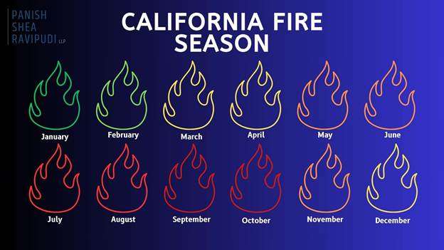
As thoroughly explained in an online guide from the Western Fire Chiefs Association, California fires can technically happen year-round, but peak fire season varies by region. In Northern California, it typically starts in June or July and lasts through late October or November. Whereas in Southern California, the peak season begins earlier, in late spring, and can continue through October.

Due to rising temperatures and limited rainfall these destructive firestorms are becoming more and more frequent, with California heading towards a year-round fire season, as with the devastating wildfires in Los Angeles County in January 2025.

California Fires Are Getting Worse

Due to California’s geography and climate, wildfires are not a new phenomenon and would occur regardless of the existence of humans. Yet in recent years, there has been a significant increase in the regularity of record-breaking fires in terms of overall destruction, frequency, and size. 

  • Between 1973 and 2024, the western U.S. saw an average increase of 37 extra “fire weather” days each year, typically marked by high heat, low humidity, and strong winds. This trend is especially severe in California, where these dangerous conditions now happen more often, turning what was once a seasonal threat into a year-round fire risk.
  • In January 2025, Southern California was hit by a string of intense wildfires, including the massive Palisades and Eaton Fires. Together, these blazes destroyed more than 18,000 buildings, took 30 lives, and displaced over 200,000 residents. The Palisades Fire, in particular, ranked as the third-most destructive wildfire ever recorded in the state’s history.
  • According to CAL FIRE, the top four most destructive wildfires in California history have all occurred within the last eight years.
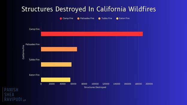
  • Camp Fire (November 2018) 18,804 structures destroyed.
    • Palisades Fire (January 2025) 6,662 structures destroyed.
    • Tubbs Fire: (October 2017) 5,636 structures destroyed.
    • Eaton Fire: (January 2025) 5,418 structures destroyed.
  • Every year, California is confronted with more destructive, record-breaking fires that redefine the danger of California wildfires and demonstrate the dire circumstances many Californians live under. 

California Counties Most At-Risk From Wildfires


Currently, more than 2.3 million acres of land in California is considered to be “high” or “very high” risk for wildfire, with a handful of California counties containing many of these acres within their borders.

Riverside County

  • Based on Cal Fire’s Fire Hazard Severity Zone maps, large portions of Riverside County are rated as “Very High” for wildfire risk. This is increased in regions such as the San Bernardino National Forest, Santa Ana Mountains, and areas around Palm Springs and Temecula.
  • FEMA ranks Riverside County as one of the highest-risk areas for wildfires in California, giving it a maximum risk score of 100%. The county is projected to lose an estimated $319 million each year due to wildfires.
  • Over 70% of structures in Riverside County are at risk of wildfire damage.
  • With an ever-growing population of more than 2.5 million, the risk of wildfires in Riverside County remains a constant danger to the populous.

San Diego County

  • According to updated CAL FIRE maps, San Diego County has seen a 26% increase in areas classified as “Very High Fire Hazard Severity Zones,” growing from about 647,000 to over 871,000 acres. What’s especially concerning is that more urban neighborhoods are now falling within these high-risk zones.
  • Many communities are situated in the Wildland-Urban Interface, where development meets undeveloped wildland, increasing the potential for property damage and loss to wildfires.
  • Several San Diego County cities, including Chula Vista, Del Mar, Carlsbad, Poway, Santee, and San Marcos, have experienced a 10% minimum increase in areas classified as “Very High Fire Hazard.” Poway, in particular, now has nearly 80% of its total land area designated within this most severe fire risk zone.

San Bernardino County

  • With a population exceeding 2 million, many residents live in areas classified under high to very high fire hazard severity zones.
  • Urbanization has led to previously undeveloped high-risk regions being populated, increasing the number of homes and structures at risk.
  • Many cities such as Big Bear Lake, Chino Hills, Colton, Fontana, Hesperia, Rancho Cucamonga, Redlands, Rialto, San Bernardino, Upland, and Yucaipa fall within the very high fire hazard severity zone.
  • Approximately 53% of buildings in San Bernardino are at risk of wildfire, with a high-risk level.
  • San Bernardino experiences increased drought conditions, contributing to heightened wildfire potential.

Los Angeles County

  • In March 2025, CAL FIRE’s updated maps designate extensive areas in Los Angeles County as “Very High Fire Hazard Severity Zones including cities such as Los Angeles, Malibu, Pasadena, Santa Clarita, and Glendale.
  • Los Angeles’ “Very High Fire Hazard Severity Zones” expanded from 646,838 acres in 2011 to 817,212 acres in 2025.
  • Urban expansion into grasslands and timberlands has increased the population now living in the Wildland-Urban Interface (WUI) hazard areas.
  • Areas where wind-blown embers can ignite distant structures now affect approximately 1.3 million structures in Los Angeles County.

Ventura County

  • 88,000 acres in Ventura County fall into the “very high” fire hazard category, a 54% increase from previous years.
  • Many communities in Ventura County are located where urban neighborhoods meet wildland areas, which raises the risk of wildfires threatening homes and critical infrastructure.
  • Almost 80% of buildings in Ventura are vulnerable to wildfires, with a large number falling within high-risk zones.
  • Extended dry periods and below-average rainfall have created perfect conditions for wildfires, turning Ventura County’s fire season almost a year-round risk.

Steps to Take if You Live in a High-Risk Wildfire Area

If you live in an at-risk area for a wildfire, as many Californians do, there are precautions and actions you can take in the event of a wildfire in your area.

Before a Wildfire

  • Regularly clean roofs, gutters, decks, and patios of leaves, pine needles, and other flammable debris.
  • Store gasoline and other flammables in approved containers away from the structure.
  • Attach garden hoses long enough to reach all areas of your property.
  • Keep firefighting tools accessible.
  • Review and update your insurance policies.
  • Videotape your home and possessions periodically for insurance documentation purposes.
  • Create and practice a wildfire evacuation plan, including routes and safety procedures.
  • Keep essential personal items (e.g. passports, birth certificates, photographs, valuable jewelry) in an easy to access location.
  • Build and store accessible emergency supply kits for each member of the household.
  • Remove flammable vegetation and materials within at least 30 feet of your home.

During a Wildfire

  • Stay informed on evacuation orders and the direction of the fire.
  • Gather all essential belongings and emergency kits in preparation for evacuation.
  • Follow a pre-planned evacuation route.
  • Listen and follow the directions of first responders.
  • Be prepared to either drive or evacuate on foot.
  • Secure all pets.
  • Remain calm.

After a Wildfire

  • Only return home when authorities say it’s safe.
  • Inspect your property for structural damage, gas leaks, and electrical issues.
  • Watch for hotspots, ash pits, or weakened trees and structures.
  • Report the damage and start the claims process as soon as possible.
  • Speak to a wildfire attorney

Click here to read the full report.


Global wildfire cooperation agreement signed by G7 nations

PM participated in the 51st G7 summit meeting at Kananaskis, in Canada on June 17, 2025.

Multiple nations recently signed a first-of-its-kind agreement to boost global wildfire readiness across the globe.

The “Kananaskis Wildfire Charter” was signed by each of the countries in the “Group of Seven,” or G7, including Canada, France, Germany, Italy, Japan, the United Kingdom, and the United States. It was also signed by the “non-enumerated member” European Union and non-member leaders from Australia, India, Mexico, South Korea, and South Africa.

“We, the Leaders of the G7, are deeply concerned that the world has experienced record-breaking wildfires across every forested continent over the past decade, often overwhelming available national resources and requiring governments to request assistance from other countries,” the charter’s introduction reads. “These increasingly extreme wildfires are endangering lives, affecting human health, destroying homes and ecosystems, and costing governments and taxpayers billions of dollars each year.”

The charter establishes a roadmap for each nation to follow to increase international wildfire preparation, mitigation, and resilience in a variety of ways, including:

  • Adopting a “whole of society” approach by collaborating with various public and private entities, implementing mitigation actions grounded in scientific research, and educating the public on wildfire causes.
  • Strengthening global wildfire response through data sharing, developing common training protocols, and improving timely access to basic firefighting equipment.
  • Focus on wildfire recovery through identifying areas for active restoration efforts, prioritizing wildfire-resilient infrastructure, and encouraging research to support scale-up ecological restoration.

The charter is the first time G7 leaders have passed a wildfire-specific agreement, Ilya Goheen with the University of Toronto’s G7 Research Group told The Canadian Press. She also said leaders may have avoided including mentions of climate change in the charter to placate U.S. President Donald Trump.

Canadian Prime Minister Mark Carney, however, reportedly mentioned climate change in his closing news conference as he listed numerous challenges facing the world. He said recovering from wildfires is something felt “intensely here in the Prairies.”

Click here to read the full charter.

Understanding circumpolar wildland fire capabilities: Wildfires in the Arctic

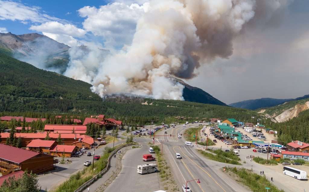
The Riley fire started June 30, 2024, near Denali National Park and Preserve in Alaska. It spread quickly, requiring park staff to evacuate. All photos by Troy Bouffard.

By Troy Bouffard and Edward Soto

The Arctic is undergoing profound environmental shifts, marked by unprecedented warming and ecosystem changes. A critical consequence of this transformation is the rise of extreme wildland fire events across all eight Arctic states, especially the United States (Alaska), Canada, and Russia.

These fires represent a shared northern challenge, transcending borders and impacting everything from carbon release and permafrost degradation to air quality and community safety. While bilateral cooperation on firefighting resources exists, notably between Canada and the United States, a comprehensive, circumpolar platform for collaboration on wildland fire preparedness, mitigation, and response has yet to develop. This gap highlights the need and opportunity for a shared understanding of how each Arctic nation manages wildland fire events.

This article is from a special issue of Wildfire magazine from the International Association of Wildland Fire and the Arctic Council. In this issue scientists, policy experts, community and Indigenous leaders provide clear insights on what is occurring with wildland fire in the Arctic and how best to respond, locally, nationally and internationally.

The Riley fire started June 30, 2024, near Denali National Park and Preserve in Alaska. It spread quickly, requiring park staff to evacuate. All photos by Troy Bouffard.

The Arctic Council Emergency Prevention, Preparedness, and Response (EPPR) Working Group publication, Circumpolar Arctic Wildland Fire Operational Baseline Report, aims to fill this research gap by establishing a foundational understanding of the existing operational capabilities and primary information sources for wildland fire response within each Arctic state.

The report’s value lies in presenting each nation’s operational picture, identifying potential areas for enhanced collaboration, and providing policymakers, operational decision makers, and researchers with the necessary baseline knowledge to engage in further studies and activities. By surveying existing governance operational structures, response systems, information resources, and logistical support mechanisms, the report serves as an important information source toward developing more integrated and effective circumpolar wildland fire management strategies in a rapidly changing Arctic.

OPERATIONAL LANDSCAPES

The report details the diverse approaches each Arctic nations takes toward wildland fire management, reflecting differences in operational governance, geography, and historical fire regimes, which can vary significantly depending on traditional management approaches and risk levels.

CANADA

Wildland fire management primarily falls under provincial and territorial jurisdiction, with the federal government responsible for Parks Canada and military lands. The Canadian Interagency Forest Fire Centre (CIFFC) plays a crucial coordinating role, facilitating resource sharing (personnel, equipment, aircraft) and information exchange both domestically and internationally, particularly with the United States through compact agreements.

By July 7, the Riley fire fire was 31 per cent contained, and evacuation status in the Denali Borough was lifted. The park resumed normal operations but some areas remained closed while crews continued to fight the fire.

Canada uses the Canadian Wildland Fire Information System for predictive services and situational awareness, incorporating data from the Meteorological Services of Canada and the Canadian Forest Fire Danger Rating System. The Canadian Armed Forces may provide support to civil authorities when requested and civilian resources are overwhelmed. Response uses a standardized incident command system, adapted for Canadian use, ensuring interoperability. Resource warehousing is also decentralized at the provincial / territorial level.

THE KINGDOM OF DENMARK (INCLUDING GREENLAND)

Denmark presents a unique structure where both civil and military emergency response capabilities reside under the Ministry of Defence, primarily executed by the Danish Emergency Response Agency (DEMA). Response follows the Emergency Preparedness Act and the National Crisis Management System, adhering to a sectoral principle for assigning responsibilities.

Given Greenland’s vast ice cover and Denmark’s relatively low wildland fire frequency, the focus is largely on an all-hazards approach with a structural fire emphasis. The Danish Meteorological Institute provides weather data, contributing to fire danger indices, often focused on agricultural settings. Response typically starts at the municipal level, escalating to DEMA if needed. Specific wildland fire equipment exists but is integrated within the broader rescue service resources.

FINLAND

The Ministry of the Interior, through its rescue services and regional rescue departments (managed by wellbeing services counties), leads wildland fire response as part of an all hazards mandate under the Rescue Act. The Finnish Defence Forces provide assistance (equipment, personnel, expertise) when requested by civil authorities. The Finnish Meteorological Institute provides essential weather and predictive services, including a forest fire index, which can trigger aerial surveillance flights. Due to intensive forest management, large wildland fires are relatively rare. Resource coordination occurs between wellbeing services counties, with the ministry coordinating international aid. Finland uses the Virve communication network, interoperable with Nordic counterparts via TETRA., the public safety telecommunications network. Training is conducted via the Emergency Services Academy Finland, emphasizing all-hazards response.

ICELAND

Civil authorities, specifically the Department of Civil Protection and Emergency Management under the National Commissioner of the Icelandic Police within the Ministry of Justice, have the sole lead for emergency response. There is no military, though the Icelandic Coast Guard assists in maritime areas and can be involved in suppressing remote wildland fires. The Civil Protection Act provides the framework for an all-hazards response structure from national to municipal levels. Wildland fires have been historically rare due to fuel types, though this may change with climate warming. Consequently, specific wildland fire information sources and specialized training are limited.

The Icelandic Meteorological Office provides general weather forecasting but focuses on more prevalent hazards such as volcanoes and avalanches. Response follows established civil protection plans, resourced locally first, with escalation pathways nationally and through the EU Civil Protection Mechanism.

NORWAY

Responsibility is shared between the Ministry of Justice and Public Security (primary authority via the Directorate for Civil Protection – DSB) and the Ministry of Defence. The DSB provides administrative oversight, while operational response resides with municipal fire and rescue services. The Norwegian Civil Defence and the Armed Forces / Home Guard can provide reinforcement and disaster assistance when needed, forming the total defence concept. Norway uses a unified management system, adapted from the incident command system, but command typically remains at the municipal level. The Norwegian Meteorological Institute collaborates with DSB, utilizing an adapted Canadian Fire Weather Index for risk assessment specific to Norwegian conditions. Resources are primarily municipal, with some national assets such as DSB-administered helicopters available during fire season or high danger periods. Norway also uses European resources such as the Copernicus Emergency Management Service (CEMS) and the Emergency Response Coordination Centre (ERCC).

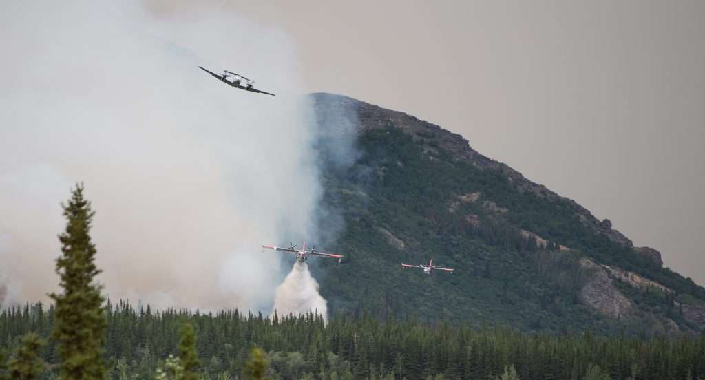
Every aircraft in Alaska that has a tank has been active on this fire today,” Danali Park public information officer Paul Ollig told alaskasnewssource.com on June 30, 2024.
Every aircraft in Alaska that has a tank has been active on this fire today,” Danali Park public information officer Paul Ollig told alaskasnewssource.com on June 30, 2024. Photo Troy Bouffard

THE RUSSIAN FEDERATION

The Federal Forestry Agency (FFA), under the Ministry of Natural Resources and Environment, is the lead agency for wildland fire protection and suppression, operating through territorial authorities. The Forest Code and federal law On Fire Safety define responsibilities, assigning coordination functions to the FFA, which establishes federal and regional headquarters. The Ministry of Emergency Situations, known as EMERCOM, handles fires in populated areas and provides support, while the Ministry of Defense’s Forestry Department manages fires on defense lands. Authority is delegated to the subjects (regions) of the Russian Federation, which develop annual consolidated fire suppression plans detailing resources (personnel, machinery, equipment) from various state, municipal, and other involved entities. The FFA oversees information reliability and coordinates interregional manoeuvring of resources. The Russian government’s Aerial Forest Protection Service (Avialesookhrana) provides specialized aviation resources, including aircraft and parachute firefighters.

SWEDEN

The Swedish Civil Contingencies Agency (MSB), under the Ministry of Defence, holds responsibility for civil protection, public safety, and emergency management, including coordinating and supporting roles in large wildland fires. Operational response is led by municipal fire and rescue departments. Sweden employs a total-defence concept incorporating emergency preparedness and civil defense, involving collaboration among government agencies, municipalities, regions, industry, and NGOs. The Swedish Meteorological and Hydrological Institute provides fire risk assessments using the Canadian Fire Weather Index during the fire season. Response is resourced locally / regionally, with cross-border municipal agreements and support from MSB, which maintains equipment depots and coordinates national / international aviation assets, including rescEU resources hosted in Sweden. If resources become scarce, MSB can prioritize allocation.

THE UNITED STATES

Wildland fire response is characterized by extensive interagency cooperation, coordinated nationally by the National Interagency Fire Center (NIFC). NIFC integrates federal agencies within the departments of agriculture and interior, state forestry agencies, and others under common incident command procedures and safety guidelines. The Department of Defense provides support to civil authorities upon request from NIFC, typically as a surge capability. Information sources are coordinated, with National Oceanic and Atmospheric Administration / National Weather Service providing key weather and predictive services. Firefighter qualifications and operational standards are standardized nationally through the National Wildfire Coordinating Group. Resources (personnel, aviation, equipment, supplies) are managed through interconnected interagency systems – Incident Qualifications and Certification System (IQCS), Interagency Resource Ordering Capability (IROC), National Fire Equipment System (NFES) caches –allowing for efficient mobilization from local to national levels. Unmanned aerial vehicles are increasingly integrated into operations.

CROSS-BORDER COOPERATION: NORDRED, RESCEU AND THE NORDIC REGION

Beyond national capacities, regional cooperation mechanisms significantly enhance response capabilities, particularly in the Nordic region. Nordred facilitates rescue collaboration (information sharing, operations) among Denmark, Finland, Iceland, Norway, and Sweden, supported by agreements at both national and cross-border municipal levels. Additionally, these nations, along with other European countries, participate in the EU Civil Protection Mechanism and its rescEU component, which provides a reserve of resources, including firefighting aircraft, coordinated through the Emergency Response Coordination Centre for international assistance. These frameworks are integral to Nordic preparedness and response culture.

This baseline report illuminates the diverse, yet often complementary approaches Arctic nations employ to manage wildland fires. While significant operational collaboration already exists within subregions such as North America and the Nordic countries, facilitated by shared systems (such as variations of the incident command system), common standards, and established agreements (such as forest fire compacts and Nordred), the frameworks and capabilities are not yet fully interoperable across the entire circumpolar Arctic.

The inventory reveals each Arctic state’s operational governance structures, key information sources (weather, predictive services, geospatial data), response protocols, and resource management systems. This foundational knowledge is crucial for identifying commonalities that can be leveraged for broader cooperation and gaps that require attention and development. As the Arctic continues to warm and wildland fire regimes intensify, understanding these national operational baselines is paramount.

Troy Bouffard, U.S. Army (Ret.), has a master’s degree in Arctic policy and a PhD in Arctic defense and security from the University of Alaska Fairbanks. He is the director of the UAF Center for Arctic Security and Resilience. Bouffard is a research fellow with the United States Military Academy – Modern War Institute. He was also the former Arctic Advisor to U.S. Senator Lisa Murkowski as a congressional fellow.

Edward M. Soto, Col, USAF (Ret.) has a forest engineering degree with a graduate certificate in Arctic securities and currently works as a project manager for the Alaska Division of Forestry. His military service includes two command tours in civil engineering and aircraft maintenance. Soto has also worked as a forest engineer and in wildland fire management throughout Alaska when not in military service.