
NATO sends 40 aircraft to assist firefighters in Greece
Continue readingFirefighters are scouting for potential control lines on the Cedar Creek Fire in Western Oregon
11:20 a.m. PDT August 7, 2022
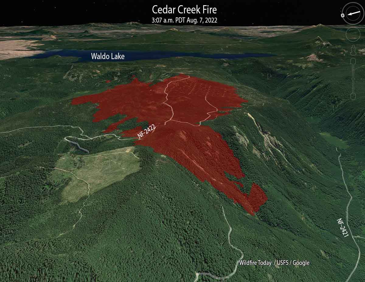 Cedar Creek Fire, looking east at 3:07 a.m. PDT Aug. 7, 2022
The Cedar Creek Fire on the Willamette National Forest in Western Oregon was very active when it was mapped by a fixed wing aircraft at about 10 p.m. Saturday, and also during a satellite overflight at 3 a.m. Sunday. Spot fires were observed 800 feet ahead of the main fire.
It has burned 1,822 acres since it started from a lightning strike August 1, one of 20 to 30 fires ignited by lightning that night. Most of it is burning on a plateau with a steep slope on the south side. The blaze is north of Highway 58, 14 air miles east of Oakridge, and 2 miles west of Waldo Lake.
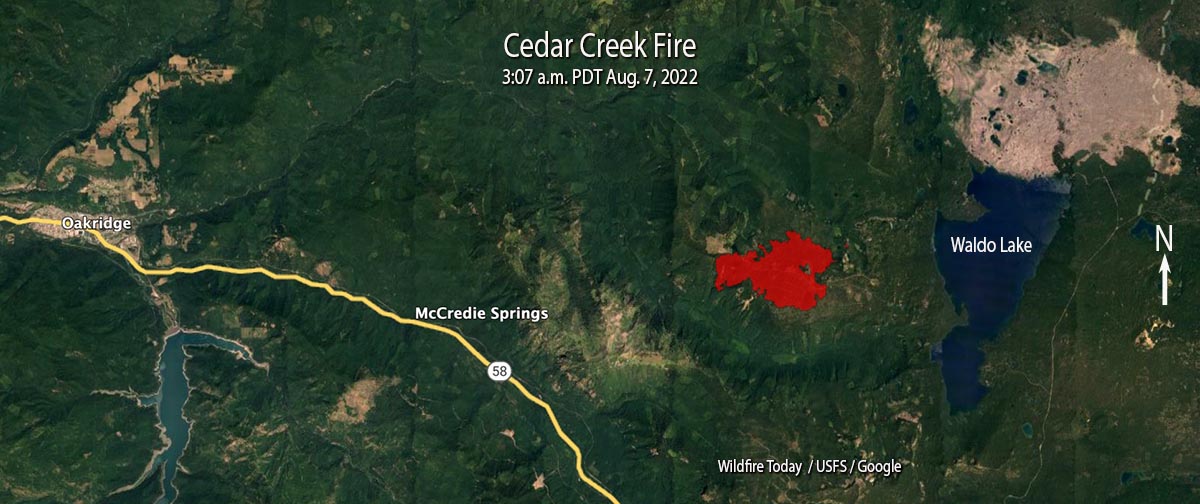 Cedar Creek Fire, mapped at 3:07 a.m. PDT Aug. 7, 2022.
A Type 1 incident management team assumed command on August 5. Since then the team has been scouting for opportunities to safely engage the fire.
Currently there are no evacuations in effect.
Update at 11:57 a.m. PDT August 9 2022.
It turns out that there is a major error in the National Interagency Fire Center fire history database. In the map below we created using their data, the polygon shown as the 68,000-acre 1991 Warner Creek Fire is completely in error and does not exist at that scale or at that location. The polygon that was not identified in the NIFC database that we labeled as “Unknown fire name in the 1990s”, is actually the 8,900-acre Warner Creek Fire of 1991. We regret the error. This is not the first time we have seen gross errors in the NIFC fire history database, especially for Oregon, and causes us to question ever using it again.
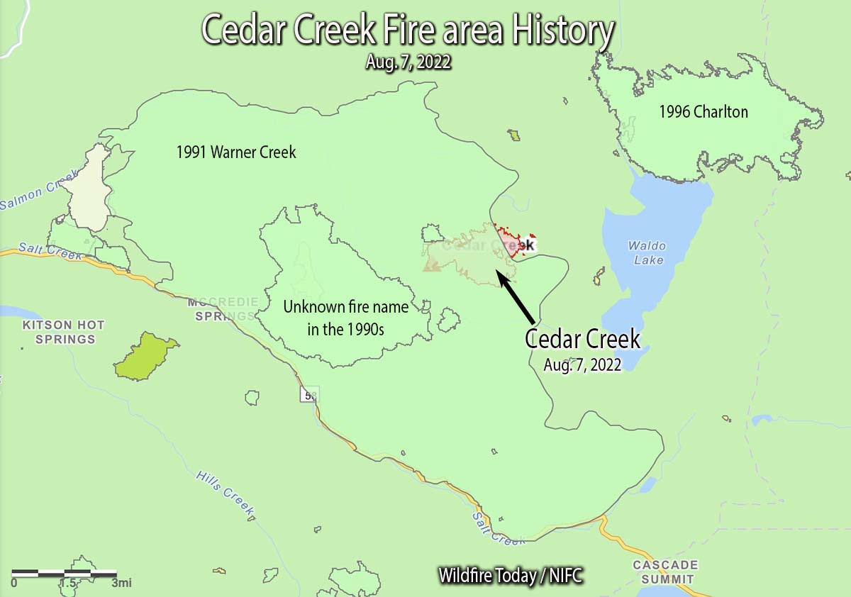
The 1996 Charlton Fire which burned 9,000 acres is 3 miles to the northeast on the north side of Waldo Lake.
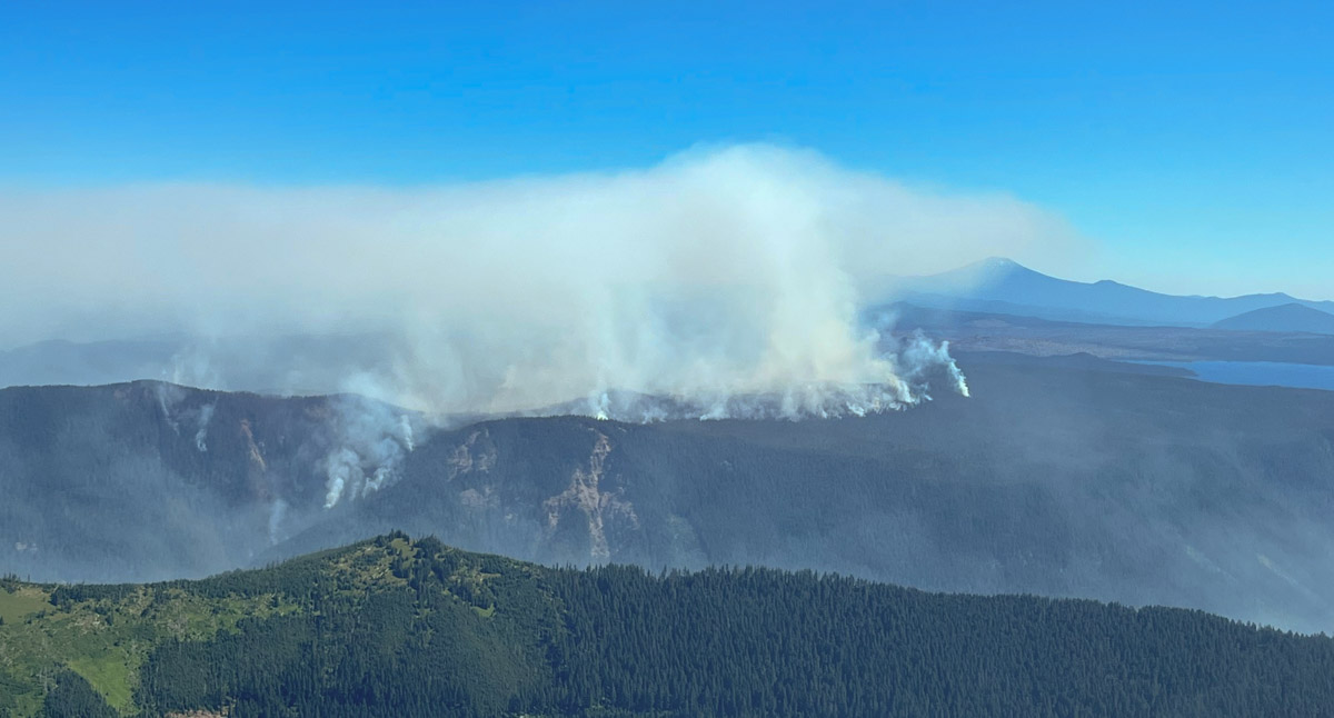 Cedar Creek Fire looking north at 11 a.m. August 6, 2022. InciWeb photo.
In the video below recorded Sunday morning, Operations Section Chief Kyle Cannon describes the current situation.
Book about California’s female inmate firefighters
“Breathing Fire” by Jaime Lowe
Continue reading2,600-gallon water bucket developed for large helicopters
 Kawak 2,600-gallon water bucket
(Updated at 9:34 a.m. Aug. 9, 2022. Based on information from Andy Mills of Kawak Aviation, we edited this article to show that the bucket holds 2,600 gallons, not 2,000 gallons as stated by the TV station.)
Kawak Aviation has developed a bucket to enable a large firefighting helicopter to transport and drop 2,600 gallons of water. The company based in Bend, Oregon says their Cascade bucket is the largest bucket built in North America.
Thanks and a tip of the hat go out to Steve and Gerald.
Six Rivers Lightning Complex of fires emerges in Northern California
Near Willow Creek east of Eureka
Continue readingVideo of DC-10 dropping on a fire east of Helena, Montana
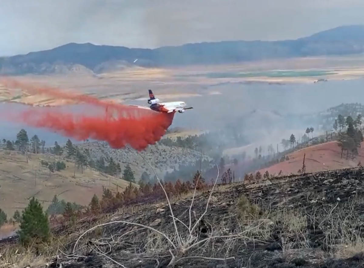 Still image from video of Tanker 914, a DC-10, dropping on the Matt Staff RD Fire. MT DNRC.
This article was first published at Fire Aviation.
The Montana Department of Natural Resources and Conservation posted an excellent video of air tanker 914, a DC-10, dropping retardant on the Matt Staff Rd Fire.
DNRC’s County Assist Team has assumed command of the Matt Staff RD fire. Great progress was made thanks to the efforts of firefighters, aircraft, and calmer weather conditions. Here’s a video of an airtanker working with crews to slow fire progress. #mtfire #fireyear2022 pic.twitter.com/YpiIrgZQY1
— MT DNRC FIRE (@MTDNRCFIRE) August 6, 2022
The fire has burned 1,538 acres 13 miles east of Helena, Montana between Canyon Ferry Lake and US Highway 287.
All evacuations on the fire were lifted at 8 p.m. Friday, August 5th. Matt Staff Road is still closed to the public. Montana’s County Assist Team assumed command of the fire at 12 p.m. on August 5th. The cooler temperatures and brief rain Saturday morning were beneficial to firefighting efforts.
The drop
The terrain seen in the video is not extreme, but appears to be outside the parameters NASA expected for a very large air tanker such as a DC-10.
Here is an excerpt from the NASA report issued March 2, 2009, titled “USFS Very Large Air Tanker Operational Test and Evaluation.”
The analysis suggests that for level or gently rolling terrain where level to slight descents (< 6-7%) are required, VLAT-class aircraft could probably be employed with few restrictions as long as they remained above 300’ AGL during the delivery.
Check out the video below posted by Kevin Osborne showing a DC-10 making a downhill drop in 2012 on the Goff Fire on the Klamath National Forest in Northern California.
Names of fires
On a related subject, here is my plea for initial attack and dispatcher personnel to keep the names of fires simple. Fires are usually named after a nearby landmark or geographical feature. One word is preferred, but certainly no more than two. Think about how many times the name will have to written, spoken, and typed into forms. Will spelling be easy, or will it be misleading, such as “Camp Fire”, or Road vs Rd?
A brief look at large wildfires in the United States this week
As of August 5, 2022
Continue readingVideo of DC-10 drop in Montana
The Matt Staff Rd Fire east of Helena
Continue readingCresson Volunteer Fire Department’s engine burned over in brush fire
Southwest of Fort Worth, Texas
Continue readingThe Staging Area, August 5, 2022
 Smoke from Oak Fire, seen from Mariposa Co. Fairgrounds, July 23, 2022. Photo, Daniel R. Patterson, USFS.
This weekend we are continuing an occasional weekend feature we started a few weeks ago. This post can serve as the beginning of an open thread where our readers can talk about issues that we have, or have not, gotten into yet. This is literally an off-topic thread. You have the floor.
The usual rules about commenting apply. And remember, no personal attacks or politics, please.
Let’s enjoy a wide-ranging conversation!
(Oh, and send us pics of staging areas — date, location, and photographer’s name would be nice.)