Skip to content

Tag: Texas

Nearly $20M awarded to rural Texas fire departments to prepare for wildfire

When a wildfire ignites in Texas, the first people on the scene are most likely from one of the state’s hundreds of volunteer fire departments, most of which have less than adequate resources to contain the flames.

Officials with the Texas A&M Forest Service say they are aware of this disparity and are attempting to address it with new funding through its Rural Volunteer Fire Department Assistance Program, specifically for firefighting equipment, training and other emergency needs. The program’s most recent $20 million award is its first round of funding for the 2027 fiscal year.

“Demand for assistance through the program routinely exceeds available funding as volunteer fire departments work to maintain and replace vehicles, protective gear and other essential resources,” the Service said in a press release on Friday. “To address longstanding funding needs, the 89th Texas Legislature appropriated $192 million in one-time additional funding to support outstanding requests.”

Click here for a full list of how much money was given to each of the state’s 518 rural departments.

The funding was announced after a very active fire season in the state. Texas recorded its largest summer wildfire in history in September when the Ross Fire burned over 90,000 acres in Palo Pinto County. The fire destroyed 167 structures, including 18 occupied residences, and damaged 95 structures.

Multiple wildfires that burned in the Texas Panhandle in February triggered an “Agriculture Emergency” due to alleged devastating losses they caused to the region’s farmers. Three wildfires in the Panhandle, including the Lavender Fire, 8 Ball Fire, and Canadian Bridge Fire, burned more than 21,350 acres, many of which were farmland.

PREVIOUS COVERAGE: Wildfires trigger ‘Agriculture Emergency’ in Texas

Wildfires trigger ‘Agriculture Emergency’ in Texas

Texas Agriculture Commissioner Sid Miller declared an Agriculture Emergency on Wednesday, stemming from alleged devastating losses to farmers in the state from wildfires.

Large portions of the Texas Panhandle are facing “extremely critical” wildfire danger due to drought conditions, above average temperatures, and low relative humidity, according to the Texas Department of Emergency Management. Officials expect critical fire weather conditions to remain through the end of the week, with the Texas A&M Forest Service listing the state at Wildfire Preparedness Level 3, meaning wildfire activity is significant and frequent enough to possibly warrant help from other regions, agencies, or states.

Three active wildfires in the Panhandle, including the Lavender Fire, 8 Ball Fire, and Canadian Bridge Fire, have burned more than 21,350 acres. Firefighters have recently contained 12 other smaller wildfires.

Miller urged Texas farmers and food producers to take advantage of the State of Texas Agriculture Relief Fund, or STAR Fund, which assists in agriculture disaster recovery through private donations. He also called on eligible ranchers and agribusinesses to use the state’s free AgriStress & Hay and Feed hotlines.

“Texans always rise for neighbors in crisis,” Miller said in a press release on Wednesday. “Panhandle families are reeling from these fires, but Texas stands united. We are activating every tool to get our agriculture heroes back in action.”

Texas Governor Greg Abbott also activated wildfire response resources and increased the readiness level of the state’s emergency operations center ahead of the forecasted critical wildfire danger. Resources included the Texas Intrastate Fire Mutual Aid System of more than 250 state, local, and out-of-state firefighters, along with Blackhawk and Chinook firefighting helicopters from the Texas National Guard.

“Texas stands ready to deploy all necessary resources to thwart any wildfire threats in our state,” Governor Abbott said earlier this week. “I directed the Texas Division of Emergency Management to deploy additional resources in preparation of potential wildfire danger this week. Texans are urged to create an emergency plan, heed the guidance of state and local officials, and limit any activites that can cause a spark to best keep themselves and loved ones safe.” 

Nearly 200 Texas counties facing wildfire disaster, governor says

Texas Governor Greg Abbott issued a disaster declaration for 191 counties on Tuesday due to heightened wildfire danger across the state.

Abbott said the counties face an “imminent threat of widespread or severe damage, injury, or loss of life” due to forecast fire weather conditions. The Texas A&M Forest Service raised the state’s wildland fire preparedness level to level 2, indicating that elevated fire danger is observed in some regions of the state. There are reportedly 11 aircraft on standby to assist ground crews in the event of widespread fires.

“Our No. 1 priority is to protect the safety and well-being of Texans across the state,” Abbott said in a press release. “I issued a disaster declaration to provide all necessary resources to communities who could be affected by wildfires. Texans are urged to regularly monitor wildfire conditions and heed the guidance of local officials and emergency management personnel to protect yourselves and your loved ones.”

The Texas Division of Emergency Management, after the declaration, activated over 100 firefighters, along with engines, bulldozers, and aircraft, through the state forest service. Chinook and Blackhawk helicopters through the Texas National Guard are also on standby, though an exact number was not given.

Credit: Texas A&M Forest Service

The state is currently experiencing a rainfall surplus, but that’s expected to morph into deficits in several areas due to ongoing drying, state forestry officials said. Areas below 25% of normal have emerged across numerous areas, as northeast Texas is expected to continue seeing fires.

“Although most of the state has seen some measurable rain in the past 30 days, it has been 2-3 weeks since any significant rain events have happened in parts of South, Central Texas, and pockets along the Red River and Northeast Texas,” the service said. “Most of the areas of highest rainfall totals in the Hill Country will disappear on the 30-day map later this week.”

Click here for Texas’ latest fire potential updates.

A prescribed burn stalled a huge Texas fire — and Smokehouse Creek Fire hits the million-acre mark

Aerial images from Hutchinson County, Texas shot with a drone yesterday show the aftermath of a huge fire adjacent to a 7-mile swath of land that was prescription burned a few months ago near Borger, a Panhandle town of about 12,000 in north Texas.

15:08 CST 02/29
15:08 CST 02/29

Northeast of there, the Smokehouse Creek Fire, the largest of at least five other active fires in the Panhandle, has burned over 1 million acres, leaving charred homes and buildings behind. The fire’s doubled in size since 03:00 CST on 02/28.

The drone images in a CNN report feature a 7-mile prescribed burn that was conducted a few months ago.

Officials with Borger’s Office of Emergency Management said the prescribed burn prevented a fire flank from spreading into the southern parts of the town, including the Meadowlark, Country Club, and Bunavista areas.

Borger map

“As much damage as we have, our proactive efforts did prevent even more,” Hutchinson County officials said. — [Panhandle fires photo gallery]

The fires in Texas and Oklahoma have burned so much land that the blackened ground is visible from space. Satellite imagery captured burn scars stretching from the Texas Panhandle into western Oklahoma Wednesday afternoon.

Satellite images from Monday morning and Wednesday afternoon show burn scars in the Texas Panhandle in the wake of devastating fires. CIRA/RAMMB
Satellite shots show burn scars in the Texas Panhandle in the wake of devastating fires. CIRA/RAMMB images.

Burn scars are often a combination of burned vegetation, debris, and a scorched layer of soil. In the satellite image above, the burn scar appears as charcoal gray and black against the tan unburned ground around it.

 ~ Thanks and a tip of the hardhat to Chris and Alison.

PLEASE ground your drone. Please.

The Texas A&M Forest Service reminds drone operators that they are not allowed to fly drones when there is a wildfire nearby.

A helicopter recently delivering water on a fire in Caldwell County nearly collided with an airborne drone, and the state firefighting agency says the drone came within just feet of the firefighting aircraft, according to a report by KBTX-TV.

Firefighters in the state of Washingon (among others)  are fed up with people flying their drones above wildfires. A state DNR official says the problem is massive and just getting worse. On Tuesday, the Washington State Department of Natural Resources posted a series of online messages warning drone operators about flying near wildfires.

The DNR said fire vs. drone incidents have occurred “multiple times this year” and have prevented aircrews from flying on fires. “It’s not cute!” it added.

Officials remind the public that drones are a serious hazard and someone could be killed if a drone should collide with a firefighting aircraft. Air ops on fires will be shut down — grounding helicopters and fixed-wing ops — if you or your buddies are flying a drone anywhere near a wildland fire.

If a drone is spotted in the fire area, firefighting aircraft will be grounded and air ops suspended until the drone leaves or is otherwise taken down.

KAGS-TV reported that the recent drone incursion in Texas came within just feet of fire aircraft. “Pilots have no way to detect a drone or know there is one present in the airspace until they see it,” said Texas A&M Forest Service Aviation Manager Jared Karns.

The FAA restricts activity around wildfires (Temporary Flight Restrictions) to ensure that firefighters have a safe space to operate in fire areas and fight fires. Incursions with a drone into a fire TFR can result in charges and very expensive fines in many states.

Close calls and injuries in Texas

A 215-acre wildfire in San Jacinto County was contained on August 2 according to a report by ABC-13 News. That afternoon, resources were requested from Texas A&M Forest Service (TAMFS) on the Snowhill Fire. Shortly after 1 p.m. crews on the fire reported moderate to high fire behavior with several structures threatened, evacuations under way, and road closures in place.

The agency also reported that two of its firefighters suffered burn injuries when fire behavior intensified at about 5 p.m.

The agency’s 24-hour report noted that fire behavior intensified on a part of the fire where a dozer crew was working. The two injured firefighters were not wearing PPE properly and both experienced first- and second-degree burns to the face, hands, and sides.

The two firefighters were transported to a hospital and both were treated and released.

Two days later the agency released its 72-hour report on an aircraft incident in Travis County.

On August 1 at about 10:30 p.m. an air tactical aircraft working a different fire was involved in an incident at Austin-Bergstrom International Airport — about 5 miles southeast of downtown Austin — after flying the Powder Keg Pine Fire near Bastrop, about 150 miles southwest of Lake Livingston near the location of the Snowhill Fire.

Texas map

TAMFS resources were requested on August 1 on the Powder Keg Pine Fire in Bastrop County. Numerous aircraft were dispatched, including the Air Attack Platform at the Gillespie County Airport in Fredericksburg. The aircraft is a King Air C90A turboprop registered to Safford Aviation Service in Coolidge, Arizona (which had not yet replied to a request for comment when this was posted).

At about 8:40 p.m. the aircraft was released from the fire and made a 30-minute flight back to the Gillespie County Airport. On approach, though, the pilot and ATGS reported an issue with landing gear indicators; just two of the three indicated that the landing gear was down and locked. The pilot and ATGS attempted to fix the issue manually, and at about 9:30 p.m. they reported they had two hours of fuel left and intended to fly to Austin-Bergstrom, an FAA-controlled airport, where they’d do fly-bys so the control tower could see whether the landing gear was actually down. After two fly-bys, the tower told them it appeared to be down, and they approached for landing.

Upon landing the aircraft, though, the right landing gear collapsed, and the right propeller blades contacted the concrete and were damaged. The right gear appeared to have collapsed back into the aircraft gear hold, according to the report.

Neither the pilot nor the ATGS was injured and no civilians were injured. Both the pilot and ATGS were in constant radio communication with TAMFS dispatch in College Station, and the aircraft was tracked using the real-time map-based Automated Flight Following (AFF) system. The NTSB will investigate.

Spectrum News reported that Texas A&M Forest Service, the state’s lead agency for wildfire response, on Monday raised the state’s preparedness level to 4 — its second-highest level. The agency said over the past seven days it has responded to 80 wildfires burning 8,521 acres, with 41 fires since Friday.

The forecast for this week calls for more triple-digit temperatures with few chances for rain, and 164 Texas counties are now under burn bans.

More than 70 cars burn in grass parking lot near Temple, Texas

Robinson Family Farm Fire
Robinson Family Farm Fire. Lisa Adams.

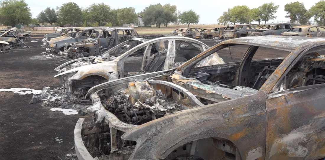
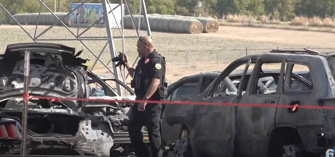
The parking lot at the Robinson Family Farm in Temple, Texas turned into an inferno Saturday afternoon during their annual pumpkin patch event. According to the owner of the farm no injuries were reported but approximately 73 vehicles were destroyed when a wind-driven fire spread rapidly through the mowed pasture used as a parking lot.

Robinson Family Farm Fire
Robinson Family Farm. KCENN.

From KWTX:

The Temple Fire & Rescue Department responded to the blaze at around 1 p.m. Oct. 15. Multiple fire departments from Little River Academy, Troy, Rogers, Salado, Holland, Bartlett and Belton were called to assist.

The first units to arrive found approximately 10 cars on fire in the pasture area used for parking but due to the numbers of cars involved, the East Side Strike Team was called to bring in additional resources.

Fire crews were able to move some of the cars out of the way of the flames.

One attendee on Facebook wrote, “I have to say that is the most exciting and expensive pumpkin patch we’ve been to” after their family van “burned to a crisp.”

Robinson Family Farm Fire
Cars burn at Robinson Family Farm in Texas. KCENN.

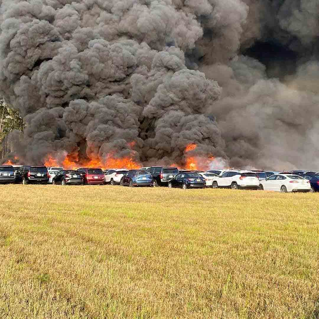
On April 3, 2020 3,516 rental cars parked in a mowed field near the Southwest Florida International Airport (RSW) near Fort Myers, Florida burned in a similar manner.

“The cars were stored in a location not ordinarily used for any specific purpose”, Victoria B. Moreland, Director of Communications and Marketing for the airport said at the time. “The large number was due to the car rental agencies serving RSW not renting inventory during the peak season due to the current COVID-19 crisis.”

rental cars burn fire Fort Myers Airport
More than 3,500 rental cars burn at Southwest Florida International Airport at Fort Myers, Florida April 3, 2020. Fort Myers Fire Department photo.

At one point firefighters in Florida used dozers to build fireline through the cars to stop the spread.