Sen. Murkowski threatens retaliatory budget cut for the DOI

muskoxen
Muskoxen in the Arctic National Wildlife Refuge. USFWS photo.

In retaliation for the Obama administration’s proposal to set aside more than 12 million acres in Alaska’s Arctic National Wildlife Refuge as wilderness, Alaska Senator Lisa Murkowski has threatened to cut the budget of the Department of the Interior. The wilderness designation would prevent any chance of oil exploration in the area, which would infuriate many Republican politicians.

Four agencies in the DOI  employ large numbers of wildland firefighters — the National Park Service, Fish and Wildlife Service, Bureau of Indian Affairs, and the Bureau of Land Management. If Senator Murkowski is able to impose a large cut in the DOI budget, perhaps hundreds or thousands of employees could lose their jobs, with some of them being firefighters.

But the Senator says “jobs are transitory”.

Below is an excerpt from an article at Alaska Public Media:

…But as chair of the Energy Committee and a member of the Appropriations Committee, U.S. Senator Lisa Murkowski has some level of oversight over the Department of the Interior. Murkowski says Secretary Sally Jewell will appear before her twice in the coming weeks.

“She will be before my energy committee on the Tuesday next, as she presents the budget,” Murkowski said. “And then I will have her in front of my Interior appropriations subcommittee on March 4, so I’m going to have plenty of opportunity to engage with her.”

Murkowski notes she is in a position to affect the Department of Interior’s budget.

“If budgets are reduced and people lose their jobs, that is an outcome. Right now, what people in this region seem to be concerned about is losing their land. A job is transitory,” Murkowski said. “This Secretary is going to have this job for just two more years, this President is going to have this job for less than two years, but the land – the land – that’s what I’m here to protect. This is what we need to be fighting for. I’m not going to be fighting for some short-term job for a bureaucrat.”

In response, Jewell says she is “hopeful” that there will not be retaliatory cuts, and notes the Department provides aerial mapping of Alaska and monitors earthquakes and volcanic eruptions in the state.

Alaska Supreme Court rules on lawsuit over burnout

Rex Creek Fire
The Rex Creek Fire on August 4, 2009, part of the Railbelt Complex in Alaska. Photo by ADF.

In 2009 firefighters in Alaska conducted a burnout operation on the Railbelt Complex of fires 45 mile southwest of Fairbanks. Part of the fire was on private land and four of the landowners filed a lawsuit asking for $100,000 each charging that the burnout was an illegal “taking” of their property. They also charged “negligence and intentional misconduct”, saying the state failed to adequately mop up after rains knocked down the fires, which later re-ignited.

The Alaska Supreme Court, reviewing a previous decision by a Superior Court, ruled that the landowners may be eligible for compensation.

Below is an excerpt from an article in the Newsminer:

A Superior Court judge dismissed the eminent domain claim in December 2010, finding the state’s actions “did not constitute a taking because they were a valid exercise of its police powers,” and dismissed the negligence and intentional misconduct claims on the grounds of government immunity, according to court documents.

The landowners appealed the decision.

The Supreme Court’s ruling affirmed the Superior Court’s dismissal of the negligence and intentional misconduct claims but reversed the dismissal of the eminent domain claim, “remanding it to the Superior Court for further consideration of whether the specific exercise of the state’s police powers at issue here was justified by the doctrine of necessity,” according to the opinion documents.

“The doctrine applies only if the state demonstrates the existence of ‘imminent danger and an actual emergency giving rise to actual necessity,’ an inquiry that is fact-specific,” the Supreme Court’s 28-page ruling states.

The landowners’ attorney, William Satterberg, was pleased with the ruling and expects the case to now be decided by a jury. He said the state did not need to set the burnout fires on his clients’ properties and that the fire was “basically a fire of convenience.”

“It was easier to light it there than it was to do it a mile away,” he said. “We do know they had lots of time, they could have gone down a mile away from their property. They thought about it for 11 days before they did it.”

Another excerpt from a previous article in the Newsminer:

“The point is, what’s a piece of burned-out property worth versus a piece of beautiful lakeside property?” said Bill Satterberg, who is representing the landowners. “You can’t just go around destroying people’s property and not pay for it.”

The Railbelt Complex of fires eventually burned over 600,000 acres.

Evergreen’s 747 “Supertanker” made its first drop on a live fire in North America on the fire. It was done at no charge to the fire, with the company wanting to demonstrate the capability of the 20,000-gallon air tanker.

Evergreen's 747 "Supertanker"
Evergreen’s 747 “Supertanker” drops on the Railbelt Complex of fires in Alaska, July 31, 2009.

Below is a video of a large burnout operation on the Railbelt Complex, July 16, 2009, narrated by the Incident Commander. .

We first wrote about the lawsuit in 2009.

UPDATE, December 1, 2014: As Emmett pointed out in a comment this situation has some similarities to a lawsuit filed by a Montana rancher over the 2000 Ryan Gulch Fire. The heart of that case was the contention that firefighters who usually fought fire in the flat, wet southeast United States used poor judgement in selecting and implementing an indirect strategy of backfiring or burning out, rather than constructing direct fireline on the edge of the fire. In the process, they argued, more land burned than was necessary, including 900 acres of a privately owned ranch.

Thanks and a tip of the hat go out to Keith.

Alaska state troopers helicopter crash caused by flight into bad weather and department’s “punitive culture”

I would be interested in hearing from our readers about how any lessons learned from this accident (summarized by the NTSB below) might be applicable to fire aviation. Often, the weather that allows for large wildfires is not in the form of rain, snow, and icing, however it can involve strong winds, turbulence, thunderstorms, and high density altitude conditions. Add the hazards of flying into canyons low and slow at 150 AGL and it can be a challenging, unforgiving environment.

One fatal accident that comes to mind is the MAFFS 7 crash that occurred July 1, 2012 as the aircraft was attempting to drop retardant on the White Draw Fire near Edgemont, South Dakota, killing four on board. It was basically blown into the ground by a downburst out of a thunderstorm as it was attempting to drop on the fire.

Below is the NTSB’s very brief summary of a helicopter crash in Alaska that killed three people.

****

“WASHINGTON –The National Transportation Safety Board today determined that the March 30, 2013 crash of an Alaska Department of Public Safety helicopter was caused by the pilot’s decision to continue flying into deteriorating weather conditions as well as the department’s “punitive culture and inadequate safety management.”

The crash occurred on a mission to rescue a stranded snowmobiler near Talkeetna, Alaska. The pilot, another state trooper and the snowmobiler were all fatally injured. Contributing to the accident was the pilot’s “exceptionally high motivation to complete search and rescue missions,” which increased his risk tolerance and adversely affected his decision-making, the Board found.

Among the recommendations the NTSB made today as a result of the investigation was for Alaska and other states to develop and implement a flight risk evaluation program.

“These brave few take great risks to save those in harm’s way,’’ said NTSB Acting Chairman Christopher A. Hart. “There needs to be a safety net for them as well.”

Among the Board’s findings was that the Alaska Department of Public Safety (DPS) lacked policies and procedures to ensure that risk was managed, such as formal weather minimums, formal training in night vision goggle operations and having a second person familiar with helicopter rescue operations involved in the go/no-go decision.

During the investigation of this accident, the Board found that the pilot had been involved in a previous accident. The Board found that the DPS’s internal investigation of the earlier accident was too narrowly focused on the pilot and not enough on underlying risks that could have been better managed by the organization.

The Board concluded that DPS had a “punitive culture that impeded the free flow of safety-related information and impaired the organization’s ability to address underlying safety deficiencies relevant to this accident.”

Since 2004, the NTSB has investigated the crashes of 71 public helicopters responsible for 27 deaths and 22 serious injuries.

“Public agencies are not learning the lessons from each other’s accidents,” Hart said. “And the tragic result is that we have seen far too many accidents in public helicopter operations.”

As a result of the investigation, the Board made recommendations to Alaska, 44 additional states, Puerto Rico, the District of Columbia and the Federal Aviation Administration.”

****

The complete NTSB reports on the Alaska accident.

Unique display of results from fire effects study

Lake Clark fire effects
Screen shot from the fire effects study portal about a fire in Lake Clark National Park and Preserve

The Alaska National Park Service Fire Ecology crew returned to the site of the Currant Creek Fire in Lake Clark National Park and Preserve in Alaska one year after it burned in order to collect data about the effects of the fire. They created an interactive map tour of their findings, which turned out to be a pretty interesting educational tool.

Thanks and a hat tip go out to Traci.

Wildfire briefing, June 2, 2014

Rescued wolf pups to find home

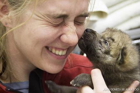
Wolf pup at Alaska Zoo

The five abandoned wolf pups that were rescued by firefighters on the Funny River Fire on March 27 are doing well and will be adopted by the Minnesota Zoo, located south of Minneapolis-St. Paul in Apple Valley, Minnesota. The pups will remain at the Alaska Zoo until veterinarians are certain the animals are old and healthy enough for transport. When found last week, they weighed about 2.5 pounds apiece and suffered from dehydration and punctures from porcupine quills.

Thirty five applicants awarded funding for their fire research projects

The Joint Fire Science Program announced that 35 applicants have received funding for their proposed fire-related research. The topics include smoke, fuels treatment effectiveness, fire behavior and effects, bats and fire, people and fire, and more.

Fire Training in Pennsylvania

New York Times obituary for Robert Sallee

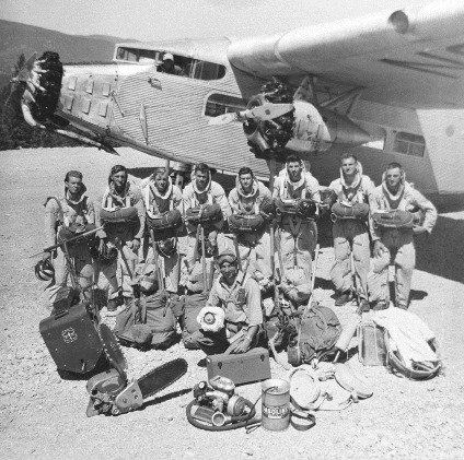
typical smokejumpers Mann Gulch Fire Ford Trimotor aircaft
Typical smokejumpers and their equipment around the time of the Mann Gulch Fire, with their Ford Trimotor aircaft.

On May 29 we wrote about the death of Robert Sallee, the last survivor of the 1949 Mann Gulch Fire, and later we linked to some rare photos of the incident.

Surprisingly, the New York Times on May 31 published an obituary of Mr. Sallee. John N. Maclean pointed it out to us, saying that he learned some things from the article. After the death of his father, Norman Maclean, John helped to edit the almost finished Young Men and Fire, the book his father wrote about the fire. John later wrote several books of his own about wildland fires, the latest being The Esperanza Fire.

Below is another photo related to the fire. It was taken in Mann Gulch by Alan Thomas, who was the editor at the University of Chicago Press who worked on Young Men and Fire with the Macleans.

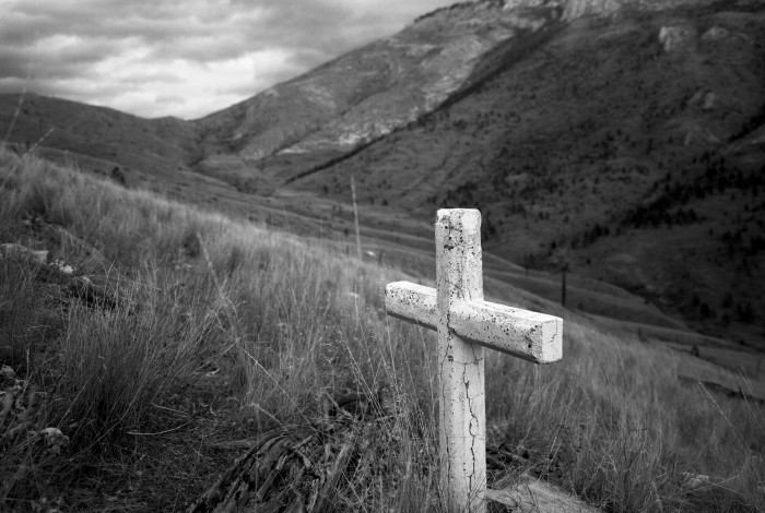
Mann Gulch,
Mann Gulch. Photo by Alan Thomas of the University of Chicago Press.

Colorado Fire Chief talks about how climate change has affected his job — and his life

The video below features Elk Creek, Colorado fire chief Bill McLaughlin, whose department fought the Lower North Fork Fire in 2012 that killed three residents and burned 4,140 acres. “Climate change is very real,” says McLaughlin. “It’s changed my entire life.”

Firefighters rescue wolf pups

Medics Eric Zucker and Alicia Renfer rehydrate and remove porcupine quills from a wolf pup
Medics Eric Zucker and Alicia Renfer rehydrate and remove porcupine quills from a wolf pup. KNWR photo by Stephen Miller.

From LiveScience:

Firefighters rescued five wolf pups from an abandoned den Tuesday (March 27) as they battled the massive Funny River Fire in southern Alaska’s Kenai Peninsula. The pups had not been hurt by the blaze, according to a Facebook post by firefighters with the Kenai Wildlife National Refuge, who discovered the den.

Medics with the fire crew fed the fuzzy brown puppies glucose (sugar water) and plucked porcupine quills from their skin. In reward, they got some excited licks from the tiny pups. With help from the Alaska Department of Fish and Game, the litter was taken to Anchorage, where they await a permanent home.

The pups are being treated and housed at the Alaska Zoo in Anchorage, where they are on antibiotics for the porcupine quill wounds. Since the pups have been handled by humans, they might not be candidates for release back into the wild.

Kenai National Wildlife Refuge firefighter Brian Nichols with wolf pup
Kenai National Wildlife Refuge firefighter Brian Nichols with wolf pup. KNWR photo.

Our primary coverage of the Funny River fire is HERE.

Satellite photos of Funny River Fire

Funny River Fire in Atmospheric Cyclone
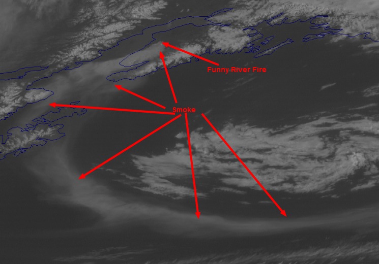
Funny River Fire in atmospheric cyclone, via Discover Magazine.

Discover Magazine has a very interesting animation from a weather satellite, showing the smoke from the Funny River Fire on the Kenai Peninsula in southern Alaska being swept up into a huge cyclonic system over the northern Pacific. The image above is a screen grab, to which we added the arrows and the smoke and fire labels, but check out the video animation.

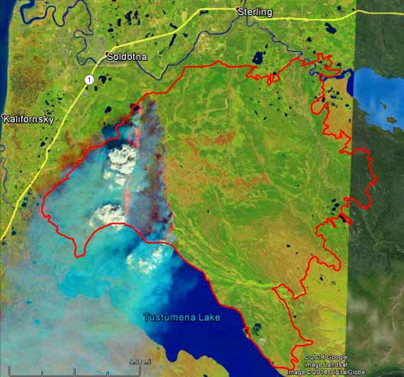
Funny River Fire, Landsat
Funny River Fire, Landsat, false color, 1:13 p.m. local time, May 20, 2014. The red line is the fire perimeter at 12:29 a.m. on May 29, 2014.

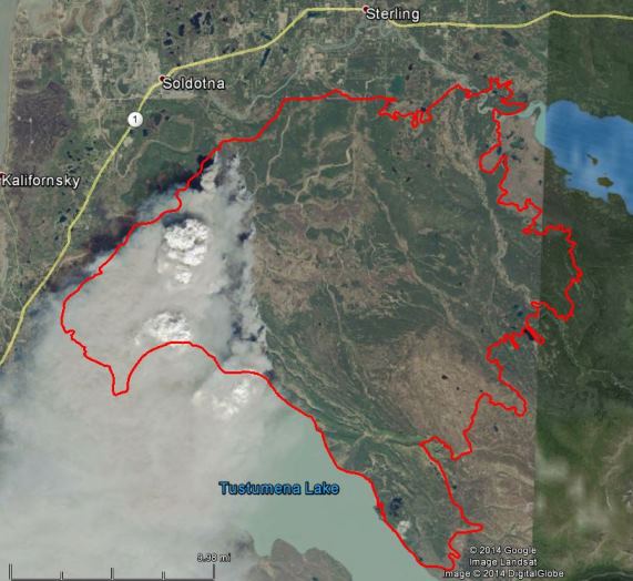
NASA has released photos of the Funny River Fire at Soldotna, Alaska taken May 20 at 1:23 local time by a Landsat satellite a day after the fire started on the 19th. We added a red line to the photos that represent the fire perimeter at 12:20 a.m. on May 29, 2014. In the false color photo above, the infrared sensor can see through some of the smoke and detects the heat, shown as orange, on the east and west fire edges.

The photo below is true color, as would be seen by the human eye.

Funny River Fire, Landsat,
Funny River Fire, Landsat, true color, 1:13 p.m. local time, May 20, 2014. The red line is the fire perimeter at 12:29 a.m. on May 29, 2014. The clouds are pyrocumulus, created by the fire.
Funny River Fire May 25
Funny River Fire. Photo taken from the ground on May 25, 2014 by Josh Turnbow.

Our primary coverage of the Funny River fire is HERE.

Alaska: Funny River Fire becomes megafire

 (UPDATE at noon, MDT, May 29, 2014)

The Funny River Fire at Soldotna, Alaska has burned 192,831 acres and the Incident Management Team is calling it 46 percent contained.

Below is a report from the Team:

Cooler, damper weather moderated fire activity on Tuesday which allowed firefighters to switch from defense to offence for the first time since the Funny River Fire started nine days ago. Crews reinforced the containment lines on the west side of the fire in the Kasilof and Sterling Highway areas, and in the Funny River Road area. Progress was made with containment line on the north side of Torpedo Lake on the north side of the Kenai River. Overall fire containment is now 30 percent, with 713 firefighters working to keep the fire away from populated areas.

The evacuation order along the Funny River Road was cancelled yesterday and most residents returned to their homes. All remaining evacuation advisories have been lifted. The Lower Skilak Lake Campground remains closed until further notice.

Five structures were confirmed as lost to the fire. The owners were notified by the Kenai Peninsula Borough. These structures include one outbuilding (the main structure was saved), and four recreation cabins with limited access.

On Tuesday firefighters rescued five abandoned wolf pups on the fire. Check out the story and the photos HERE.

We posted some very interesting satellite photos of the fire in another article.

****

(UPDATE at 6:28 p.m. MDT, May 27, 2014) An update from the Funny River Fire incident Managment team at about 6 p.m. MDT:

Firefighters made excellent progress yesterday extending containment lines on the west side of the fire in the Kasilof and Sterling Highway areas. Crews also completed burnout operations along the northern perimeter (south of Funny River road) late in the day helping to secure areas that had burned over containment lines on Sunday. The fire grew to over 182,000 acres as winds continued to push the fire perimeter northeast towards the Skilak Lake Road and further east into the wildlife refuge area. Overall fire containment is now 30 percent.


The evacuation order along the Funny River road has been cancelled. Residents are allowed to return to their homes. This area remains under an evacuation advisory. The evacuation advisory along the Sterling Highway was also lifted. The Kenai Keys area remains under an evacuation advisory. The Lower Skilak Lake Campground remains closed until further notice.

**** (UPDATE at 10:35 a.m. MDT, May 27, 2014)

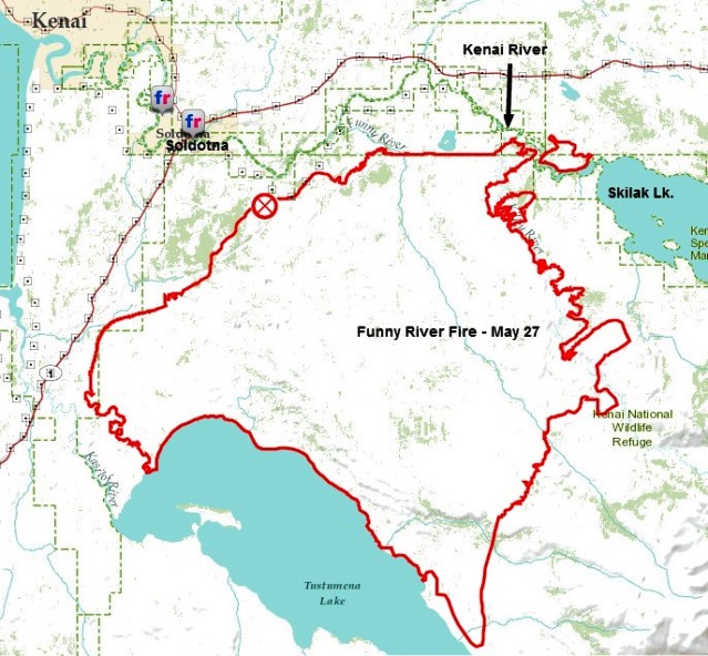
Funny River Fire, May 27, 2014
Funny River Fire, May 27, 2014 (ESRI). The black annotations were added by Wildfire Today.

On Monday the Type 2 Incident Management Team for the Funny River Fire at Soldotna, Alaska mentioned that the fire had crossed the Kenai River near Torpedo Lake. The map, above, that we found on the Team’s Facebook page (it is not on their InciWeb page) shows that the fire has become established east of the river. It is no longer just a spot fire. Monday night the Team said the fire had burned 176,069 acres and 670 personnel were assigned. There have been no serious injuries. It is becoming difficult to find current, official information about the fire. Sometimes it is placed on InciWeb, occasionally it can be found on the Alaska Wildland Fire Information site, and then there’s Facebook and ESRI. There is a report from a Twitter user that it is raining in the fire area:

**** (UPDATE at 8:45 p.m. MDT, May 26, 2014)

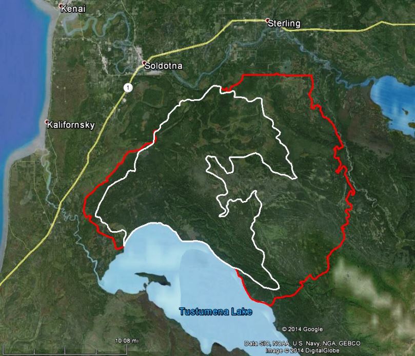
Map of Funny RiverFire May 26, 2014
Map of Funny RiverFire. The white line was the perimeter at 9 p.m. May 23. The perimeter at 4 a.m. May 26 is shown in red.

The incident management team running the Funny River Fire at Soldotna, Alaska reported the fire has burned 158,585 acres and it is 30 percent contained. It crossed the Kenai River Sunday afternoon near Torpedo Lake just east of the Kenai Keys. Several spot fires within the Keys did minor damage but were quickly put out. The team is working to confirm if any structures were lost. The wind driven fire is continuing to spread northeast towards the Skilak Lake Road. The Lower Skilak Lake Campground was evacuated and is closed until further notice. The Kenai Keys area is under an evacuation advisory. The weather forecast is calling for rain early Tuesday. Cooler and wet weather will help slow fire activity.

Continue reading