
The juveniles were taken into custody Wednesday after an interagency investigation.
Continue reading
The juveniles were taken into custody Wednesday after an interagency investigation.
Continue readingThis WBIR video explains the various systems for communicating emergency messages, such as evacuations, to the public, and why they did not work very well as the Chimney Tops 2 Fire burned into Gatlinburg, Tennessee last week.
There are multiple emergency alert systems but according to WBIR the one used by the National Weather Service can only push an emergency message to cell phones for one of the following situations: tornado, flash flooding, extreme wind, hurricane, typhoon, dust storm, or tsunami. Wildfire is not on the list, which seems, especially in retrospect after Gatlinburg, to be a serious oversight.
It is a good lesson that could be learned by communities at risk from wildfire and other emergencies.

Above: The Drought Monitor issued November 29 showed “Exceptional Drought”, the highest category, for the Gatlinburg area and large sections of Tennessee, Georgia, Alabama, North Carolina, and South Carolina.
On Monday, December 5, the Incident Management Team (IMT) on the Chimney Tops 2 Fire that burned from Great Smoky Mountains National Park (GRSM) into the Gatlinburg area reported that it has caused the deaths of 14 people. Over 130 sustained injuries, and 1,684 structures have been damaged or destroyed. Approximately 14,000 residents were originally forced to evacuate.
There are three broad categories of conditions that affect the way a wildfire burns: weather, fuels (vegetation), and topography. When the Chimney Tops 2 Fire burned into Gatlinburg on November 28, 2016 and destroyed those structures it was driven primarily by weather — specifically, very strong winds.
But the condition of the fuel was also important since it happened during what the National Weather Service (NWS) calls “exceptional drought” conditions. Much of the southeastern United States had been suffering extremely dry conditions for two to three months.
One indicator of drought and its effect on how wildfires burn is the Keetch-Byram Drought Index (KBDI). (The fire was in eastern Tennessee near the North Carolina border.)
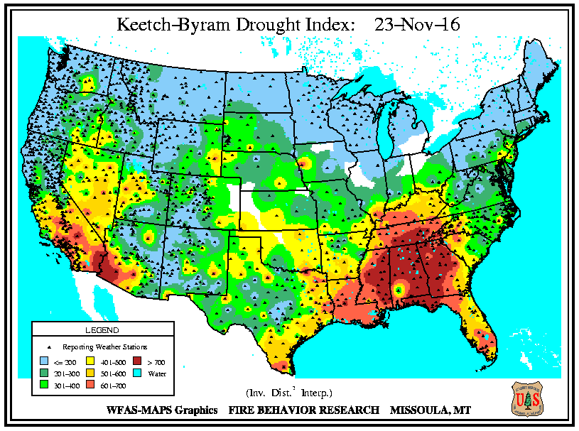
On November 23 when the fire was discovered the KBDI was 599, Molly Schroer, a spokesperson for the IMT told us. For reference, 600 or above would indicate severe drought and increased wildfire occurrence. Intense, deep burning fires with significant downwind spotting should be expected. A fire burning under those conditions would likely burn more intensely, have a rate of spread faster than normal, and have more resistance to control. Many fire managers in that situation would immediately attack emerging fires very aggressively with overwhelming force, that is, many firefighters on the ground assisted by numerous aircraft dropping water or fire retardant.
Ms. Schroer said she was not aware of any actual on-the-ground fire suppression efforts, other than perhaps some work on a distant indirect fireline, until Monday November 28, after the fire had grown large and crossed US Highway 141, the main road into the park. That is when it began moving rapidly toward Gatlinburg. Firefighting aircraft were not used until helicopters dropped water on the fire Sunday afternoon, November 27 four days after it started.
Wednesday, November 23, the day the fire started
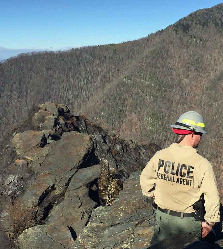
At about 5:20 p.m. the fire was discovered near the top of a steep hill called Chimney Tops not far from where another fire occurred about a week before. GRSM firefighters spotted the new fire as they returned from responding to a report of a vehicle fire. The earlier fire on the hill was named “Chimney Tops” — hence the name “Chimney Tops 2” for the new blaze.
According to Ms. Schroer, firefighters walked up the Chimney Tops Trail to the top of the hill to size it up. But very little if any fire suppression activity occurred until Monday, November 28. The action taken by firefighters on Monday was defensive, to protect threatened structures at a nearby National Park Service picnic ground.
Investigators have determined that the fire was human-caused and are asking for information from anyone who has information about people or vehicles that were seen in the area that day. The Tip Line is 888-653-0009.
Narrowing it down to human-causes is easy for an investigator. It means they eliminated natural causes, such as lightning and volcano eruptions. The fire could have been accidental, or it may have been intentional.

Above: Map showing the perimeter of the Chimney Tops 2 Fire at Gatlinburg, Tennessee as of 11 p.m. ET December 1, 2016.
(UPDATED at 4:12 p.m. ET, December 2, 2016)
Today for the first time since Gatlinburg was evacuated residents will be allowed into the city to access their property. They can enter the area between 10 a.m. and 5 p.m. today through December 6th.
According to CNN the number of confirmed fatalities has increased to 13:
Of the 13 who died, 12 were killed in the fires, and one person died of a heart attack after fleeing and being exposed to smoke, [Sevier County Mayor Larry] Waters and the county’s assistant medical examiner, Dr. Vincent Tolley, said.
The estimated number of structures destroyed officially remains at 700; it is likely that will change after the surveys are complete.
The Chimney Tops 2 Fire that burned into the city on November 29 has been mapped at 17,859 acres. Firefighting resources assigned to the fire include 17 hand crews, 31 engines, 6 helicopters, and 5 dozers for a total of 458 personnel.
The National Park Service Investigative Branch Services and the Bureau of Alcohol, Tobacco, Firearms and Explosives (ATF) continue to investigate the origin of the fire — it appears to be human caused. The park is asking for assistance from the public to gather information.
For the most current information about the Chimney Tops 2 Fire at Gatlinburg, see our articles tagged “Chimney 2 Fire”.

Above: Thursday’s satellite photo shows no large quantities of smoke from wildfires in the southern states. NASA/Wildfire Today.
Thanks to the soaking rains over the last three days the satellite photo taken Thursday shows no large concentrations of smoke from wildfires in the southern states. Of course this photo was taken from hundreds of miles overhead and would not be capable of detecting smoking logs, stump holes, and the smouldering remains of burned structures at Gatlinburg, Tennessee.
Here is an example of a satellite photo that showed large amounts of wildfire smoke on November 10, 2016.
And it does not mean the fires are out. Firefighters may still need to construct firelines around the perimeters of the fires and suppress still-burning materials that are near the fire’s edge.
The very dry soils and vegetation desiccated by the two-month drought will quickly soak up some of the precipitation making it less effective in suppressing a fire than it would have been if the weather had been closer to normal in recent months.
The Southern Area Coordination Center reported Thursday morning only two fires that were still spreading — the Chimney Tops 2 Fire at Gatlinburg, TN (+1,455 acres) and the Camp Branch Fire 9 miles west of Franklin, NC (+212 acres).
Chimney Tops 2 Fire at Gatlinburg
There are no major changes in the information provided by officials about the Chimney Tops 2 Fire. The estimated number of structures burned remains at 700 and they are still reporting 7 confirmed fatalities. The size is 17,108 acres.
A mandatory evacuation is still in effect for most of the City of Gatlinburg.
Great Smoky Mountains National Park is closed from the Gatlinburg entrance along Highway 441 to Smokemont, near Cherokee, North Carolina. Cades Cove and Oconoluftee Visitor Centers reopened Thursday.
The incident management team disclosed information about another fire they are managing east of the Chimney Tops 2 Fire. The name of this fire is unclear, but it is reported to be in the Cobbly Nob area.
For the most current information about the Chimney Tops 2 Fire at Gatlinburg, see our articles tagged “Chimney 2 Fire”.

Above: A November 29 infrared image of an area within the Chimney Tops 2 Fire in Seivier County, Tennessee. The white areas represent heat, areas that either ARE burning or they previously burned and retained some of the heat. For example, a concrete slab, ashes, and bricks would stay hot for hours after most of the fire burned out or was extinguished. The larger white rectangular objects are most likely burned structures.
On Wednesday afternoon officials confirmed that 700 structures burned in the Chimney Tops 2 Fire in Tennessee. Of that total, 300 were in Gatlinburg and 400 were in other parts of Sevier County.
The Tennessee Department of Health reported Wednesday that the death count in the fire has risen to seven and the number of injuries has increased to 45.
A mandatory evacuation is still in effect for most of the City of Gatlinburg.
Fire suppression resources assigned to the fire include 9 hand crews, 22 engines, 7 helicopters, 4 dozers — for a total of 285 personnel.
WBIR has a list of areas affected by the fire with brief descriptions of the damage.
As predicted, another round of rain assisted firefighters on Wednesday, dropping between 1.28 and 1.76 inches at four weather stations in the Gatlinburg area during the 24 hours ending at 11:50 p.m. EST.

For the most current information about the Chimney Tops 2 Fire at Gatlinburg, see our articles tagged “Chimney 2 Fire”.
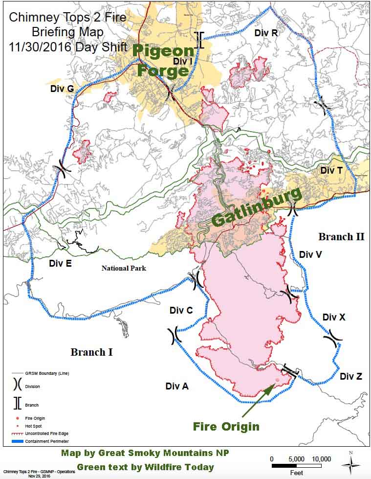
As far as we know this is the first publicly available map of the Chimney Tops 2 Fire that burned from Great Smoky Mountains National Park into Gatlinburg and Pigeon Forge, Tennessee. The incident management team reports it has burned 15,653 acres.
We are not aware of an official estimate of the number of structures destroyed in the fire since Tuesday morning’s report from the Tennessee Emergency Management Agency (TEMA) of approximately 100 homes in Sevier County Tennessee having been either damaged or destroyed.
WBIR has a list of areas affected by the fire with brief descriptions of the damage. From that information it appears that the number of structures destroyed will be much larger than the early estimate.
On Wednesday a Type 1 Incident Management Team run by Mike Dueitt assumed command of the Chimney Tops 2 Fire. Teams like this are made up of federal and state interagency team members from across the country who collaboratively manage wildland fires and other natural disasters.
The evacuation of Pigeon Forge has been lifted but is still in effect for Gatlinburg.
Firefighters will be aided on Wednesday by rain. The NWS predicts a 73 to 100 percent chance of precipitation into the evening with accumulations of about a third of an inch.
For the most current information about the Chimney Tops 2 Fire at Gatlinburg, see our articles tagged “Chimney 2 Fire”.

Above: Infrared map of the Chimney Tops 2 Fire, November 27, 2016. By Colorado’s MultiMission Aircraft.
For the most current information about the Chimney Tops 2 Fire at Gatlinburg, see our articles tagged “Chimney 2 Fire”.
(UPDATED at 11:05 p.m. EST November 29, 2016)
Sevier County officials reported that there have been three fatalities related to the fires in the Gatlinburg, Tennessee area. Sevier County includes Pigeon Forge, Gatlinburg, and part of the Great Smoky Mountains National Park. At least 14 people have been injured.
Three individuals with severe burns were transferred from the University of Tennessee’s Knoxville (UTK) Hospital to Vanderbilt Medical Center in Nashville Monday night. A fourth person with burns to their face continues to be evaluated at UTK.
Pigeon Forge officials estimate 500 people were evacuated on Monday night. Approximately 125 people remain displaced and in local shelters in Pigeon Forge. About 14,000 residents and visitors evacuated from Gatlinburg.
The National Park service estimates that a total of 15,000 acres have burned in Great Smoky Mountains National Park and in the areas in and around Gatlinburg and Pigeon Forge. On Wednesday the NPS will transfer command of the fires within the park to a Type 1 Incident Management Team run by Mike Dueitt. Teams like this are made up of federal and state interagency team members from across the country who collaboratively manage wildland fires and other natural disasters.
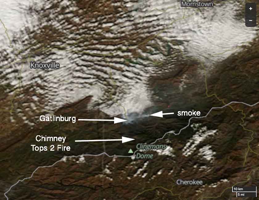
Eventually we hope to obtain a map, much better than the one above, of the fires in the Gatlinburg area. Check back later. (UPDATE: we posted a much better map on November 30.)
We do not yet have complete information about how many fires are burning, where they are, the causes, and where all of the fire(s) started that eventually burned into the communities of Gatlinburg and Pigeon Forge.
The NPS reported Tuesday morning that 80 mph winds gusts, low humidities, and drought conditions…
…caused the fire burning in the National Park to spread rapidly and unpredictably, in spite of suppression efforts on Sunday that included helicopter water drops. Wind gusts carried burning embers long distances causing new spot fires to ignite across the north-central area of the park and into Gatlinburg. In addition, high winds caused numerous trees to fall throughout the evening on Monday bringing down power lines across the area that ignited additional new fires that spread rapidly due to sustained winds of over 40 mph.
Presumably the fire within the park was the Chimney Tops 2 Fire, which started November 23 and was reported to be 10 acres Sunday evening, November 27. Apparently the NPS was not able to completely suppress the fire during that four-day period.
The Tennessee Emergency Management Agency, in their Tuesday update, wrote:
The Chimney Top Fire, which began in the Great Smoky Mountains, spread very rapidly yesterday evening as high winds pushed flames onto private property.
They were probably referring to the Chimney Tops 2 Fire.
****
(UPDATED at 10:13 a.m. EST November 29, 2016)
About 100 homes in Seiver County Tennessee have been either damaged or destroyed in wildfires that started in or near Great Smoky Mountains National Park in eastern Tennessee. The state’s Emergency Management Agency (TEMA) which conducted a quick preliminary survey, reported at 3 a.m. ET Tuesday that about 10 of those homes were in Gatlinburg. In addition, 30 other structures in Gatlinburg have been damaged or destroyed, including a 16-story hotel on Regan Drive and the Driftwood Apartments near the Park Vista Hotel.