Fires in Kansas, Oklahoma, and Texas burn hundreds of thousands of acres

fires map kansas oklahoma texas

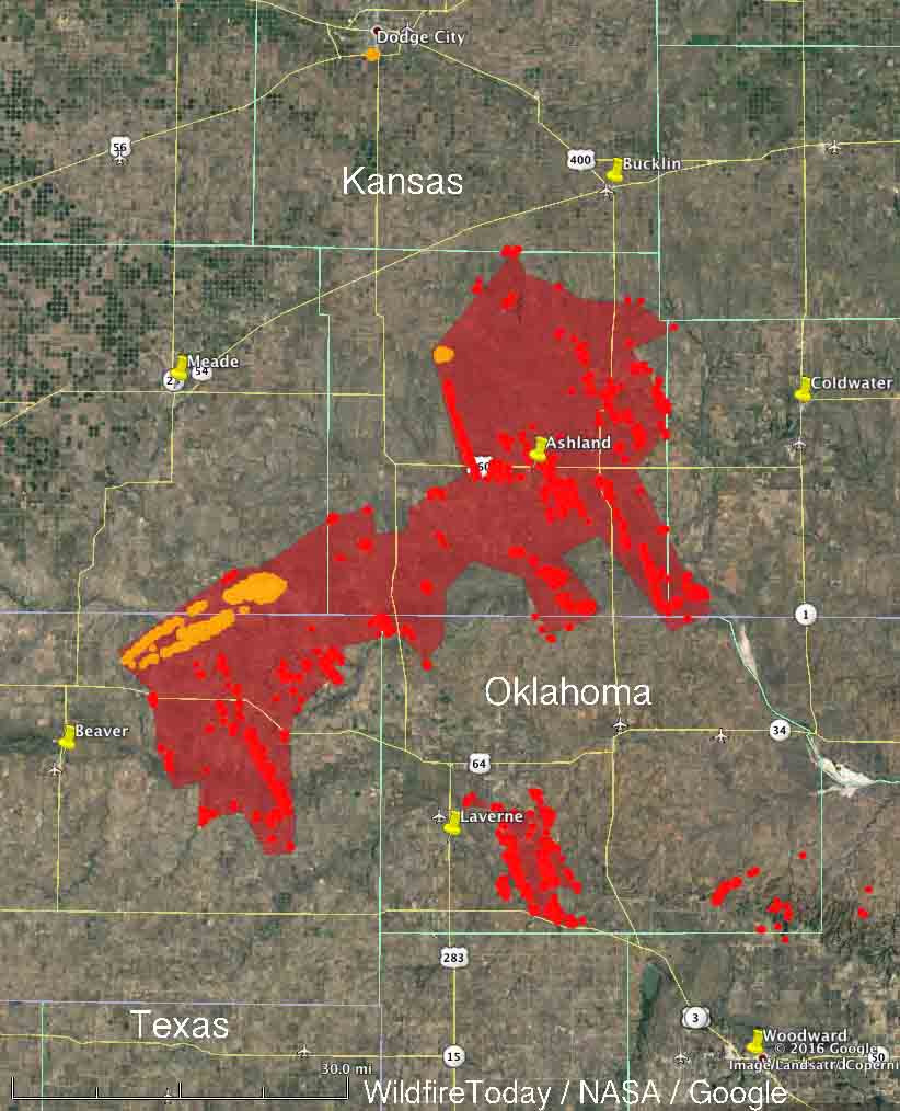
Above: The red and yellow dots represent heat detected by a satellite in the 24 hours before 11:30 a.m. CST March 7, 2017.

Published at 11:29 a.m. MST March 7, 2017

On Monday a cold front brought very strong winds to the plains of Kansas and the northern portions of Texas and Oklahoma. Gusting in some areas at over 50 mph and accompanied by low relative humidities, any wildfires that were ignited spread very rapidly, and often exceeded the capabilities of firefighters.

The largest fire started east of Beaver, Oklahoma and ran to the northeast into Oklahoma. Ashland, 40 miles away, had to be evacuated. It is not 100 percent clear if the fire in Ashland was the same fire that started in Oklahoma, but it likely was.

After the cold front passed, the southwest wind shifted 90 degrees to come out of the northwest, which converted the right flank of the fire into the head as it turned and ran to the southeast.

The fire burned in the following counties: in Oklahoma, Beaver and Harper; in Kansas, Meade, Comanche, Clark, and possibly Ford. As of 3:16 a.m. CST satellite data, the fire was still very active in some areas.

The map below shows heat detected by a satellite in the 24 hours before 11:30 a.m. CST March 7, 2017. We drew a red-tinted polygon around the heat icons for the fire east of Beaver. The satellite only collects data twice a day at roughly 12-hour intervals. As the fire spreads rapidly through mostly grass with the strong wind, it can cool and not be detected by the next satellite overflight. We don’t know if everything within our red polygon was all one fire, and even if it is there likely are many areas, some large, that did not burn. So with all those disclaimers, the red polygon includes about 600,000 acres.
wildfire kansas oklahoma
A fire that started in Oklahoma on Monday spread into Kansas burning hundreds of thousands of acres.

The red polygon we drew around the wildfire east of Laverne, OK encompases about 30,000 acres, but the same disclaimers about the fire east of Beaver also apply here.

Red Flag Warnings for strong winds and low humidities have been issued again Tuesday for Kansas and Oklahoma as well as portions of Colorado, Nebraska, South Dakota, Iowa, Illinois, and Missouri. The wind is predicted to decrease significantly on Wednesday.

Cold front drives numerous large wildfires in Kansas

map kansas wildfires

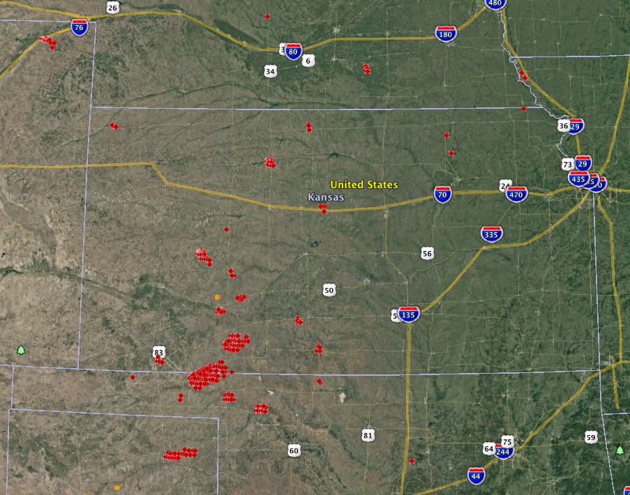
Above: Large wildfires (red) in Kansas as detected by a satellite at about 1 p.m. MST March 6, 2017.

(UPDATED at 5:43 p.m. MST March 6, 2017)

Below is an updated map showing growth of some of the fires in Kansas, especially the one 17 miles southeast of Meade, Kansas that burned from Oklahoma into the state. That one, using very rough satellite data, appears to be more than 130,000 acres.

map wildfires kansas
The red areas represent wildfires in Kansas detected by a satellite at 4:07 p.m. MST March 6, 2017.

There was a report, as yet unconfirmed, that in Kansas a tornado moved over a going fire.

****

(Originally published at 4:17 p.m. MST March 6, 2017)

Strong winds along with relative humidities in the teens and twenties are causing problems for firefighters in the western half of Kansas. The passage of a cold front is bringing sustained wind speeds of 30 to 40 mph with maximum gusts in the 40’s and 50’s.

On the map above we identified and very roughly mapped four of the largest fires. The acreages shown are estimates based on satellite detections of heat at about 1 p.m. MST on Monday. One of them has burned from Oklahoma into Kansas.

  • 53,000 acres; 17 miles southeast of Meade, Kansas. It is in Meade and Beaver Counties in Kansas, and Clark County in Oklahoma.
  • 6,500 acres; in Clark County 23 miles east of Meade, Kansas.
  • 7,000 acres; in Lane County Kansas 10 miles southeast of Dighton, Kansas.
  • 4,000 acres; in Rooks County Kansas just southwest of Stockton, Kansas. Residents in part of the city have been ordered to evacuate.

A fire in Logan County in the northeast corner of Colorado has burned 6,000 acres 20 miles northeast of Sterling.

wind and rh in kansas wildfires map
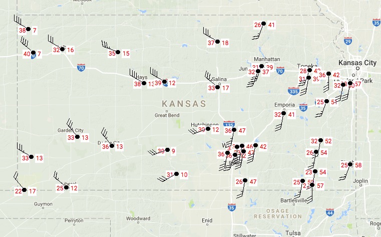
In Kansas at 3:52 p.m. MST. Sustained wind speed on the left and relative humidity on the right.

Before the cold front passed the fires were driven by a southwest wind (see the animated radar map below). As the front passes the wind is shifting 90 degrees to come out of the northwest. This could be a very, VERY dangerous situation for firefighters on the south side of the fires, as the right flank turns into the head of the fire.

map kansas fires infrared
Satellite infrared image showing heat from fires (in black) in Kansas, 3:45 p.m. MST March 6, 2017.

Smoke from controlled burn causes two accidents on Kansas highway

Osage smoke highway accident controlled burn
Scene of two accidents on Highway 56 in Kansas, February 18. The photo was taken after visibility had improved somewhat. Photo courtesy of Kansas State Firefighters Association.

Smoke from a controlled burn on February 18 caused two accidents on Highway 56 in Kansas two miles east of the Osage-Lyon county line. The series of accidents began when a truck was hit from behind when it slowed as it entered the smoke and the vehicle in front of it also slowed down.

The second accident happened when other vehicles stopped in the smoke to help those in the first accident. One driver was parked partially in the roadway when she was hit by another vehicle which then kept moving and hit two pedestrians who were helping one of the drivers in the first accident. After injuring the pedestrians the vehicle then hit another car.

The Osage County Sheriff’s Office that provided the above information reported that three people were transported to hospitals and five vehicles were damaged.

Dan Romine, Chief of Osage County Fire District #2, said the smoke across the highway was a lot worse than shown in the photo above when his fire department first arrived on scene.

Tribal fire chief set fires the department was paid to fight

The former chief of the Kickapoo Tribal Volunteer Fire Department in Kansas was indicted Wednesday on federal charges of setting fires the tribe was paid to fight, Acting U.S. Attorney Tom Beall said. Also indicted was a former volunteer firefighter.

Stephen D. Ramirez, 26, of Horton, Kansas, former chief, and Arlene M. Negonsott, 34, also of Horton, Kansas, are charged with four counts of wire fraud. The indictment alleges Ramirez recruited Negonsott, a volunteer firefighter, to set fires on the Kickapoo Reservation from July to November 2015 that the Kickapoo fire department was called to fight.

The Kickapoo Tribe in Kansas contracted with the Bureau of Indian Affairs to provide fire suppression services on the reservation. The contract called for the bureau to pay the tribe $600 for each fire it fought. The indictment alleges the defendants set six fires on the reservation.

If convicted, the defendants face up to 20 years in federal prison and a fine up to $250,000 on each count. The U.S. Department of Interior – Office of Inspector General, the Kickapoo Tribal Police and the FBI investigated.

2.7 million acres burned in prescribed fires this spring in the Flint Hills

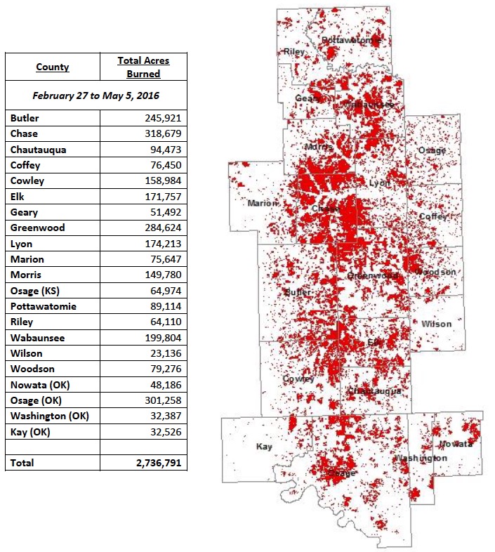
In February we posted some statistics showing that historically there is a large spike in wildfire activity in March and April in Kansas. The spring is also a time when many, many ranchers conduct prescribed fires in the Flint Hills of Kansas and Oklahoma. This year between February 27 and May 5, 2.7 million acres were treated with prescribed fire.

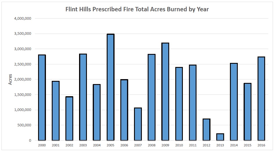
Referring to the bar graph below, and throwing out the two busiest and the two slowest data points, in a typical year land managers in the Flint Hills burn between 1.1 million and 2.8 million acres.

Flint Hills Rx fire acreages 2000-2016


Flint Hills, 2016 Rx fire acres

We thank Eric Ward of the Kansas Forest Service for providing these graphics compiled by the Kansas Department of Health and Environment..

Tagged articles on Wildfire Today about fire in the Flint Hills of Kansas and Oklahoma.

Kansas Fire Chief says nozzlemen have to ride on their trucks

Kansas Firefighter

Above: A Kansas firefighter makes a mobile attack on a grass fire from the truck. Screen grab from the KAKE video below.

Brad Ewy, Chief of the Cheney Fire Department in Kansas says their firefighters have to ride on their trucks while doing a mobile attack on a grass fire.

You take a fire when the wind’s blowing 30 miles an hour that fire’s going to be going 30 miles per hour and there’s no way we could keep up with it. We have to be on our trucks.

They (NFPA) don’t deal with grass fires like we had. The one we had in Medicine Lodge, the fire’s running 50 miles per hour. There’s absolutely no way.

There may or may not be a way to operate a nozzle safely while riding on a fire engine, but I would like to see the actual data or a BehavePlus calculation that predicts a 30 mph hour wind will cause a fire to spread at 30 mph, or a 50 mph wind will produce a 50 mph rate of spread.

Notice in the video that the crew does not take the time to cut the fence. They simply drive through it, even with the firefighter standing on the front of the truck.

NASA satellite photos of the huge Anderson Creek Fire in OK and KS

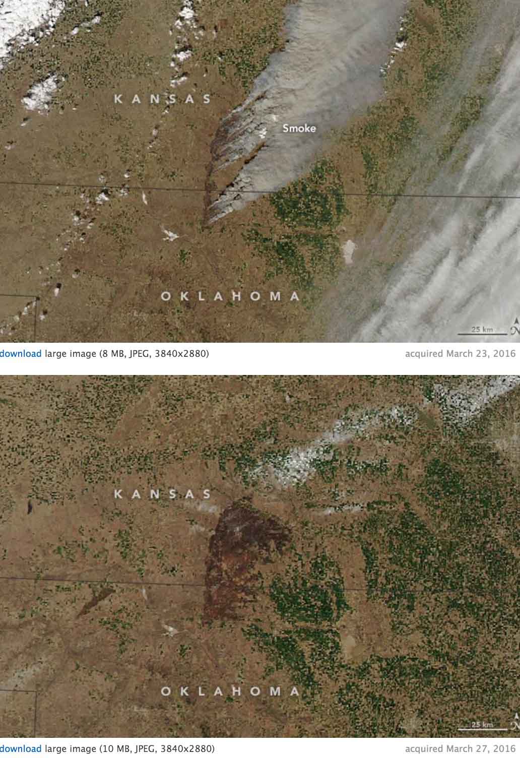
Here is the description from NASA of the images below of the Anderson Creek Fire that burned almost 400,000 acres in Oklahoma and Kansas last month:

“In late March 2016, wildfire raged across rural areas of Kansas and Oklahoma. Local authorities and media outlets are calling it the largest grass fire in Kansas history. The Anderson Creek fire started in northern Oklahoma on March 22 and proceeded to burn more than 620 square miles (1600 square kilometers) of prairie and cattle grazing land. No human deaths have been reported, though 600 cattle were killed by the fires. At least 16 homes and 25 structures were lost, as were countless miles of fencing.

The Moderate Resolution Imaging Spectroradiometer (MODIS) on NASA’s Aqua satellite acquired these two natural-color images of the fire. The first shows the extensive smoke plumes as winds whipped the fires on March 23, 2016. The second image shows the scarred land as it appeared on March 27. Turn on the image comparison tool to see the change.

The wildfire spread quickly due to dry conditions in the region; rainfall has been below normal this spring. By March 31, the fire was close to 90 percent contained, thanks to work by fire crews, the National Guard, and a few inches of snow. Click here to view drone footage of the fire at its peak.”

Anderson Creek Fire satellite photo