(UPDATED at 11:30 a.m. March 25, 2016)
@KOCOdamonlane
****
(UPDATED at 12:15 a.m. CDT, March 25, 2016)
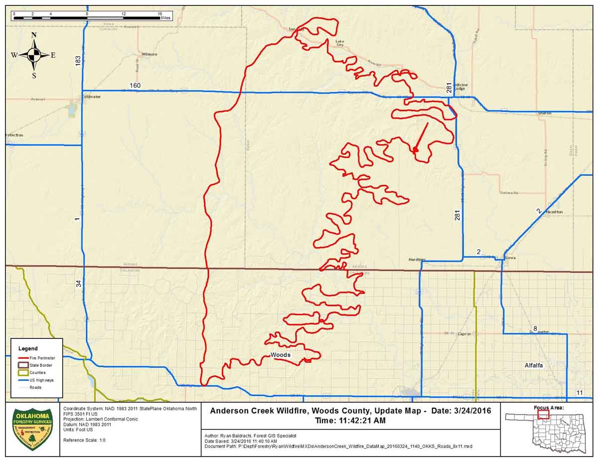
This map was provided by Oklahoma Forestry Services, along with the information that the fire had burned an estimated 397,420 acres and was 0% contained Thursday morning.
****
(UPDATED at 6:12 p.m. CDT March 24, 2016)
The video below is a recording of the briefing by public officials of Barber County Kansas the morning of March 24, 2016 about the very large fire insouthern Kansas and northern Oklahoma. It was originally broadcast on Periscope by Amy Bickel, but since recordings there are automatically deleted after 24 hours, we preserved it here. It was recorded off a computer monitor, so we apologize for the low quality.
In the briefing referenced above, the County Attorney said “397,420 acres have burned over the last couple of days”. He did not indicate if that was the size of the very large fire in our maps, or if the acreage includes multiple fires. He also said two homes were destroyed.
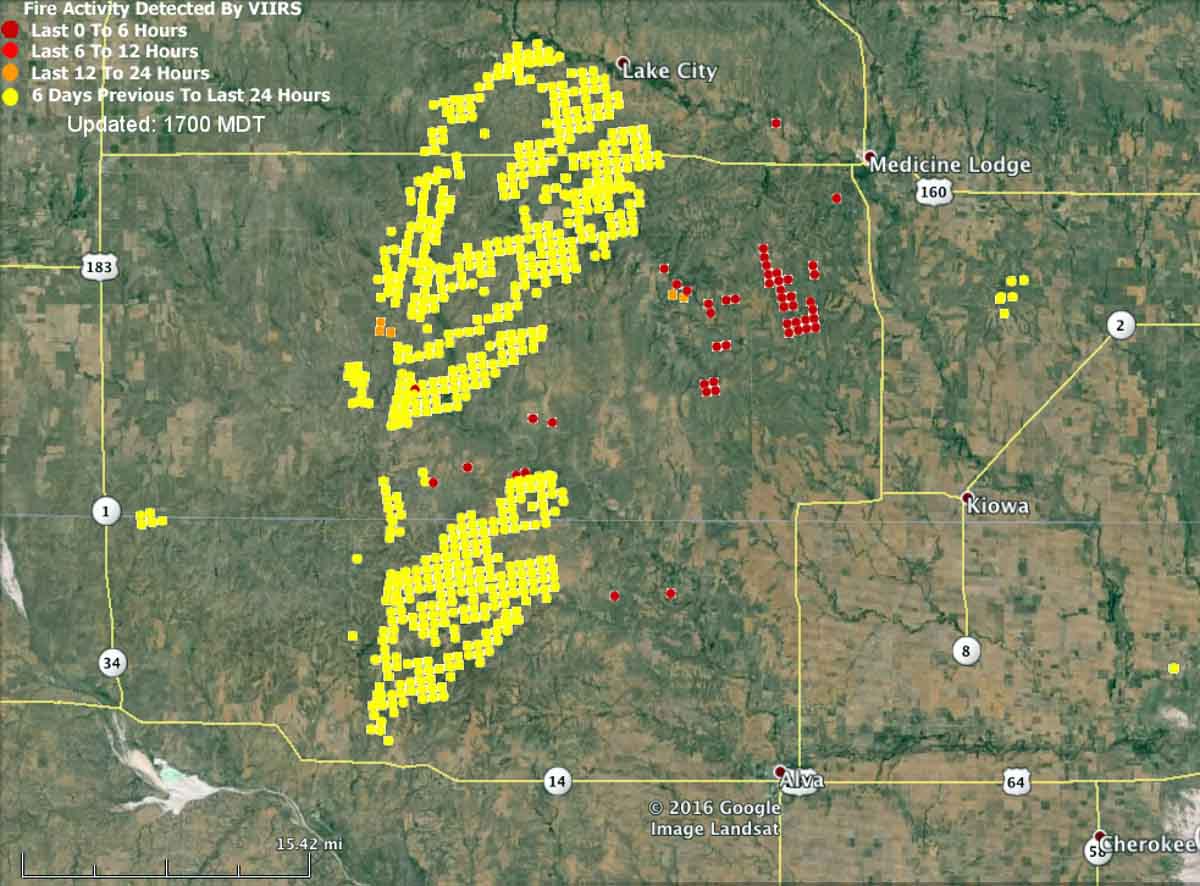
The map below shows heat detected by a satellite at 2:25 p.m. on March 24. The light vegetation in the area may sometimes ignite, burn up completely, and then cool before the next satellite overpass, which can be about 12 hours apart. In this case the mapped data may under-report the true extent of the fire.
Here is an excerpt from an article at WIBW, dated March 24 at 2:10 p.m.
Strong winds have thwarted efforts to contain a wildfire that has burned 620 square miles of rural land in Oklahoma and Kansas, and it’s now approaching populated areas.
Oklahoma Forestry Services spokesman Mark Goeller said Thursday that strong winds shifted the direction of the fire late Wednesday and overwhelmed existing containment lines.
Officials are now monitoring a part of the blaze 5 miles away from Alva, Oklahoma, where about 5,000 people live. No mandatory evacuations have been issued in Oklahoma, though Goeller says officials are forming contingency evacuation plans as crews work to slow the fire’s spread.
Goeller says wind conditions and humidity are expected to improve throughout the day, making progress on containment more likely…
****
(UPDATED at 7 a.m. CDT, March 24, 2016)
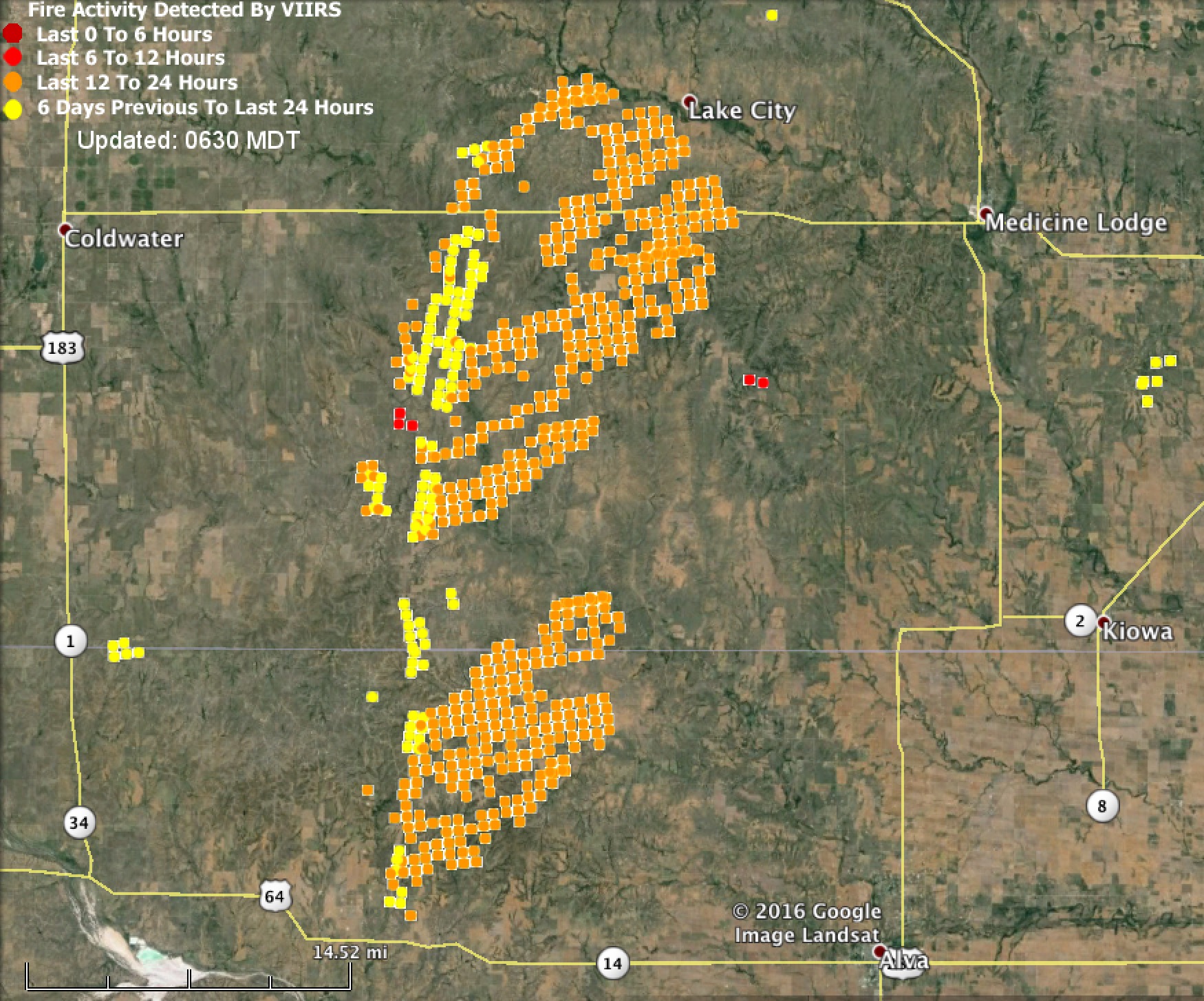
Our map of the wildfire that burned in southern Kansas and northern Oklahoma did not show much change over the last 12 hours. However, the data is obtained from a heat-sensing satellite. If light vegetation is burning it can ignite, burn out, and cool before the next satellite overflight. This means that in prairie fuels the mapped data may under-report the true extent of the fire.
Below is an excerpt from an article at WIBW, updated at 7:01 a.m. on Thursday:
The mayor of Medicine Lodge called for voluntary evacuations as massive wildfires bear down on the small town in Barber Co., the Adjutant General’s Office said.
…The blaze already consumed two houses on the northern edge of the city, and threaten to envelop the remaining 800-1,000 homes and businesses still standing…
And from MaysvilleOnline, updated at about 5 a.m. Thursday:
…The blaze went around the town of Medicine Lodge, where authorities said earlier that up to 1,000 structures were threatened and a voluntary evacuation order was issued, [Ben Bauman, director of public affairs for the Kansas Department of the Adjutant General] said. One home and outbuilding were destroyed on the outskirts of town…
Victims Left Picking Up The Pieces As Wildfire Continues To Burn In OK, KS https://t.co/CX94V9chRW #News9 pic.twitter.com/gj0B1QKa3s
— News 9 (@NEWS9) March 24, 2016
So the fire just jumped the road to directly where we moved from a few minutes ago. Wow. #kswildfire #kwch12 pic.twitter.com/vYNRIuFp4J
— Matt Henderson (@KWCHMatt) March 24, 2016
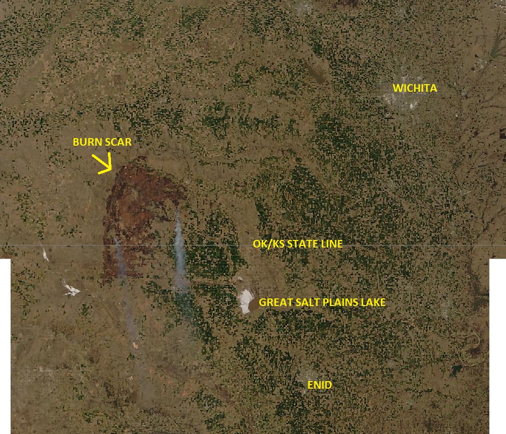
Here’s a satellite image of the fire near the OK/KS border. Notice the new gray smoke plume this afternoon. #kswx pic.twitter.com/QBhRwe7myy
— NWS Topeka (@NWSTopeka) March 24, 2016
Just had to jump in our news car and move TWICE because of change in fire direction. Situation still fluid. #kwch12 pic.twitter.com/GD5WJt4DMc
— Emily Griffin (@KWCHEmily) March 24, 2016
****
(Originally published at 9 p.m. CDT March 23, 2016)
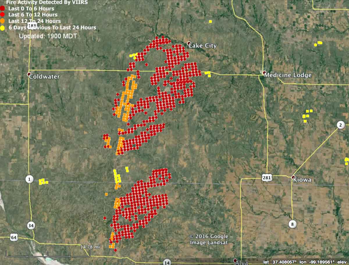
There is a very large fire, or perhaps two large fires, west and southwest of Medicine Lodge, Kansas. At 2:45 p.m. the satellite data indicated it was about a mile from Lake City, KS; 11 miles west of Medicine Lodge, KS; 16 miles east of Coldwater, KS; and 15 miles northwest of Alva, OK.
A very rough size calculated using satellite data on Google Earth estimated that the fire (or there may be two fires close to each other) has burned a total of about 150,000 acres, or 274 square miles.
Judging from the pattern of the satellite data the fire appears to be spreading toward the northeast. At 2:45 p.m. CDT it was north of Highway 14 in OK and was on both sides of Highway 160 in KS.
Below is an excerpt from an article at KWCH:
Update- 7:50 p.m.: Gov. Sam Brownback has declared a State of Disaster Emergency for the area of south central Kansas threatened by major wildfires, including Comanche and Barber Counties. The declaration authorizes state resources to assist communities affected by the fires.
A wildfire that began in Oklahoma March 22 and spread into Kansas overnight continues to burn in Barber and Comanche counties. The Kansas Division of Emergency Management is continuing to monitor the situation and is working with local, state and federal agencies.
The Kansas Forest Service and Kansas Division of Emergency Management have personnel on the scene providing technical and tactical operation assistance to Barber and Comanche Counties. US-160 is closed between Coldwater and Medicine Lodge and US 281 is closed between Medicine Lodge and the Oklahoma border.
There is quite a bit on Twitter about the fire in Kansas and Oklahoma. Here is a sample:
Blizzard warning in western Kansas I-70 shut down, possible tornadoes in eastern Kansas, Fire warnings in central Kansas #WTF ?? #HideYoKids
— Brandon Hoefler (@Brandon1915) March 24, 2016
The smoke from this fire is stretching far into central #Kansas very impressive #kswx pic.twitter.com/UqE8l4nKfT
— James Sinko (@JamesSinko) March 23, 2016
Kansas on fire. https://t.co/m1sgcA6Rnz pic.twitter.com/EEb2rhtd4z
— Eron Rawson (@erawson) March 24, 2016
GOES-13 shortwave IR images: incredible northward run of Camp Houston fire from OK into KS https://t.co/Hr8BFyoYve pic.twitter.com/hij9hDGLie
— Scott Bachmeier (@CIMSS_Satellite) March 23, 2016

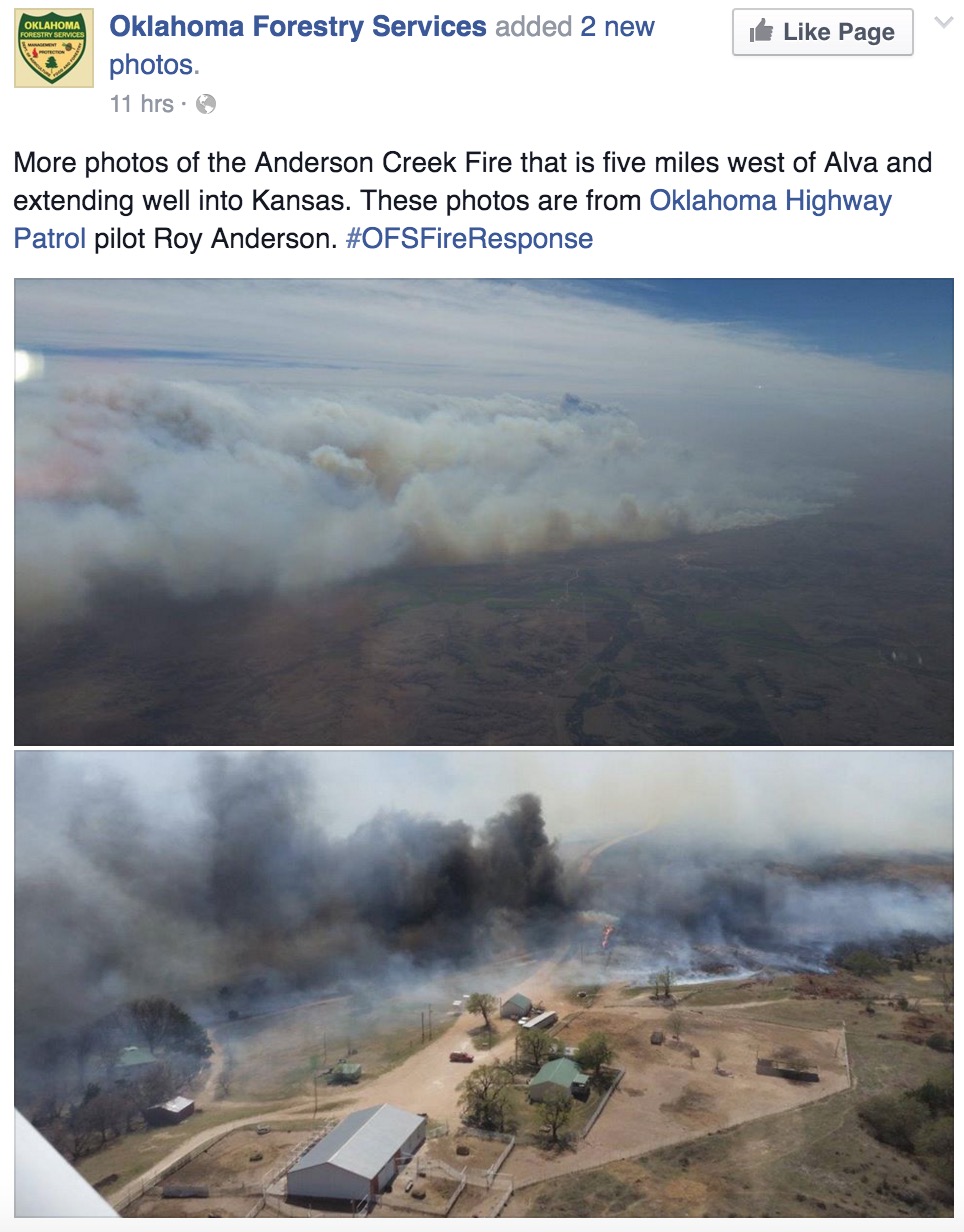
If you scroll down on this site: http://www.naturalkansas.org/gypsum.htm you will see the Gyp Hills region of southern Kansas and northern Oklahoma. This is the rough terrain with very limited roads and canyons full of Eastern Red Cedars that the crews are up against.
This is one large fire, named the “Anderson Creek Wildfire”. Tuesday at noon it started in Oklahoma with a gusty south wind and moved north out of Woods County, OK into Comanche County, KS. By Wednesday morning it had jumped US160 Highway in Kansas and crossed into Barber County, KS. A cold front shifted the direction of fire to the east and towards Medicine Lodge, KS. Luckily after a while another shift to the SE moved the fire south and away from Medicine Lodge. Today 3 fingers took off to the south creating further problems, although the wind is down to under 10mph tonight, and almost calm at times. But tomorrow (Friday) the wind will pick back up out of the south with gusts in the 30’s. Hopefully rain/snow mix on Easter Sunday will help with containment. At least 1 Chinook helicopter was making drops today, and the new Neptune air tanker will be available in Oklahoma tomorrow.
East of us here in Hutchinson, KS we had a wildfire that ran for 15 miles thru sandhills and brush on Wednesday and burnt 2 homes and 1 shop building. This fire started in Reno County, and was stopped in Harvey County. (NW of Wichita)
MCB- If what you said is correct, it’s the best information I have seen about this fire. I’m curious about your source.