The Spruce Creek Fire took off on May 14 and is burning on the San Juan National Forest northeast of Dolores, Colorado. The fire’s inside a network of FS roads within an established RxFire burn unit.
Two hotshot crews, two wildland fire modules, and an engine and crew are staffing the fire, along with a Type 3 incident management team.
Lightning ignited the fire Tuesday, and it had burned about 10 acres northeast of Dolores on the Haycamp Mesa by yesterday evening, according to The Journal.
Last month the Dolores Ranger District announced plans to burn 4,577 acres across Haycamp Mesa, and the lightning strike gave them a good start on the fuels reduction project.
Pat Seekins, prescribed fire and fuels program manager for the San Juan, said it’s thus far a low-intensity surface fire, and it’s doing exactly what they need it to do for fuels management in the area. Crews have prepped about 5600 acres. [As of 05/21 the fire’s estimated at 1640 acres; yesterday firefighters used a couple of drones in aerial ignition.]
The Spruce Creek Fire is burning northeast of Dolores on the San Juan National Forest. Crews are using existing roads as containment lines, and hope to continue the 10-acre fire next week into the planned 4500-acre prescribed burn. San Juan National Forest photo
The Durango Herald reported that firing operations should begin Tuesday under the management of a Type 3 IMT and should wrap up by Friday. “This is a great opportunity to further reduce the long-term fire risk in this area,” added Seekins. “It’s early in the fire year and we have the resources available, in terms of engines, hand crews, and helicopters, that will help us keep the fire within pre-identified boundaries.”
San Juan National Forest map
The ponderosa and aspen forest with gambel oak understory has a natural cycle of burning every 10 to 15 years. The Haycamp Mesa, though, has not seen fire in at least 40 years, according to Seekins; he said it’s had very little fire history and really needs fire in there.
July 6, 1994 – Gambel oak on the South Canyon Fire – Storm King Mountain, Colorado
Vegetation on the 1994 South Canyon Fire consisted primarily of Gambel oak, which was more than 50 years old and did not contain much dead material.
It formed a dense, green, continuous closed canopy, 6 to 12 feet tall and appeared to be unaffected by spring frosts.
Visibility within the stand was limited. The surface fuels beneath the canopy consisted of a 3 to 6 inch layer of leaf litter.
The Spruce Creek Fire started in an area that local fire and resource managers have studied for years, according to Dolores District Ranger Nick Mustoe. He says fire managers are securing indirect boundaries along natural features and existing roads to take advantage of favorable weather conditions for managing the fire.
Burning along the northern perimeter 05/20/24 — IMT photo
The strategy of using naturally occurring wildfires for hazardous fuels reduction – a policy that officials refer to as “indirect containment,” as opposed to the more derogatory and incendiary “let it burn” label that detractors have coined – is relatively new in practice on the San Juan, which would need at least 30,000 acres burned annually to catch up with the historic natural fire cycle.
Smoke will be visible to travelers along Colorado Hwy. 184 between Mancos and Dolores, and to residents of Montezuma County throughout next week. Updates will be posted on Inciweb.
Insurance isn’t the sexiest topic to either write or read about, but an extreme weather-driven downtrend of insurance agency availability is tightening the noose on an already suffocating national housing market.
The U.S. had its highest number — 28 — of annual billion-dollar weather disasters in 2023, including the Lahaina wildfire, California flooding, and Tropical Cyclone Idalia in Florida, according to a NOAA report. Homeowner insurance agencies’ response to the continually rising costs has either been to drastically increase their insurance rates or to back out from certain areas entirely.
The dire situation first made national headlines last year when numerous agencies, including State Farm, Allstate and Farmers, either paused or placed heavy restrictions on policyholders in wildfire-prone areas in California. Seven of the state’s top 12 insurance agencies have put the restrictions into effect as of November, ABC News reported.
Colorado appears to be the next state to face extremely tight, or nonexistent, homeowner insurance policies caused by increasing wildfire threats. The Durango Herald recently reported the average homeowner insurance premium in the state increased 51.7 percent between January 2019 and October 2022. Meanwhile, some new homeowners in the state are having trouble getting policies at all.
“A State Farm insurance agent in Durango wrote a couple a quote for homeowners insurance. But six days before closing, the State Farm office called to inform the Bowmans that it could not write them a policy,” said the Herald’s story on a couple who recently moved to Durango. “Geico, Travelers, other State Farm agents – all of them turned him down.”
Local insurance businesses in Durango reportedly have “plummeted” by 20 to 30 percent since insurers changed their policies sometime last September. Agents in Colorado expect the insurance issues to keep piling up in the years to come. A Climate Change in Colorado Assessment report for 2024 found climate change and increased atmospheric warming will lessen streamflows and make the state drier, leading to more and worse wildfires.
“Studies have uniformly indicated substantially worsened wildfire risk for Colorado by the mid-21st century compared with the late 20th-century, as additional warming further increases fuel dryness and enhances fire ignition and spread,” the report from the Colorado Climate Center said.
Climate change info — by Colorado State University
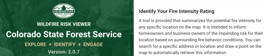
Colorado’s wildfire risk map was so inaccurate that state officials just about ignored it — for many years. The map was outdated, especially in western Colorado, where 3+ million acres of forest was covered in beetle-killed pines.
Carolina Manriquez, a lead forester with the state’s forest service, said they were supposed to use the state risk map, but they knew it was not accurate and therefore couldn’t rely on it. As the E&E News recently reported, an infusion of $480,000 in state funds resulted in a new Colorado map with updates including pine beetle damage and densely populated mountain towns.
Colorado wildfire risk viewer
Including 2017 and 2020, when annual wildfires burned more than 10 million acres, the last decade has marked some of the worst fire seasons in history. The risk is compounded by both climate change and growing wildland/urban interface areas, particularly in the West. Some states — including Colorado, Oregon, Utah, and Texas — have moved toward ensuring their fire risk information and maps are updated and more accurate, displaying areas of highest risk and most in need of prevention and mitigation.
Colorado fire risk mapping
“There is a slowly growing push among different states to do this,” said Joe Scott, founder of Pyrologix in Missoula. The firm provides utility wildfire risk assessment, catastrophe modeling, fuels treatment prioritization and management, and exposure analysis.
To improve wildfire risk maps, many states are partnering with firms such as Pyrologix that can build public-access display of fire risk data and conditions. Using satellite imagery, census information, and other data, advanced tools can determine locations and ranges of ignition probability and fire intensity, along with threatened resource types. Gregory Dillon, director of the USFS fire modeling institute, says the state-specific maps are not a duplication of federal fire maps, but rather a more refined product.
The Kansas Forest Service unveiled in September its new wildfire risk explorer, a digital interactive map that provides a detailed look at statewide fire risk. The effort began in 2018 after several major wildfires including the 2017 Starbuck Fire, which burned some 500,000 acres and destroyed or damaged more than $50 million worth of livestock, fencing, and other resources.
“A lot of state-led efforts are trying to communicate to communities and residents about the risk to private property or municipalities,” said Jolie Pollet, wildfire risk reduction program coordinator at the Department of the Interior.
That’s slightly different from federal mapping efforts focused on protecting federal lands, Pollet said. State-focused mapping can assess evacuation routes, encourage homeowners to reduce their risk, and improve prepared applications for federal grants. State improvements such as those in Kansas also help forestry and fire officials allocate limited resources to focus on the highest priority areas.
The Saint Charles Fire in Pueblo County was estimated at 266 acres Tuesday morning, October 24, and still at zero percent containment. The incident management team said warm temperatures and the lack of humidity recovery overnight had caused the fire to grow substantially, and the Pueblo Chieftain reported today that the fire is now over 300 acres.
Saint Charles Fire photo by Pueblo County Sheriff’s Office
The Saint Charles Fire started October 14. Additional resources have been ordered and are arriving daily.
Crews reported slightly increased humidity and cooler temperatures yesterday, but further warm and sunny conditions were forecast for Wednesday, with shifting light winds picking up in the afternoon. Stronger winds out of the west at 11-15 mph with gusts up to 20 mph were predicted for Wednesday by late evening, with increased winds and fire activity resulting in further smoky conditions.
About 170 firefighters are working on the fire.
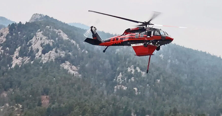
Sikorsky UH-60A helicopter at work on the Saint Charles Fire — from the incident facebook page.
Resources include three helicopters, two SEATs, and three large airtankers, along with an air attack aircraft.
Four nearby neighborhoods are on pre-evacuation notice, including Tara J, Simonson Meadows, Aspen Acres, and the entire San Isabel area; the Pueblo County Sheriff issued a burn ban for the county until the fire is contained.
According to the Custer County Sheriff’s Office, the fire is about a half mile from the Custer County line.
The Colorado State Forest Service is requesting applications for the Forest Restoration and Wildfire Risk Mitigation Grant Program. The CSFS estimates that $7.5 million will be available for the 2023-24 grant cycle. The program assists with funding community-level actions in three major areas:
reducing wildfire risk to people, property, and infrastructure in the interface
promoting forest health and the use of woody material for forest products and energy
encouraging forest restoration projects
Colorado State Forest Service
As outlined in the Steamboat Pilot, there are two main types of qualifying projects for funding:
Fuels and Forest Health Projects — must reduce risk of damage to property, infrastructure, water supplies, or other high-value assets from wildfire, or limit the likelihood of wildfires spreading into populated areas. Projects must promote forest health through sciene-based forestry practices that restore ecosystem functions, structures, and species composition.
Capacity Building Projects — must increase community capacity by providing the community with resources and staffing necessary for forest restoration and wildfire risk mitigation projects.
The following individuals, organizations, or entities may apply:
Local community groups such as homeowner, neighborhood, or property associations located within or close to the wildland/urban interface.
Local government entities including counties, municipalities, fire protection districts, and other special districts in or near the interface.
Public or private utilities, including water providers, with infrastructure or land ownership in areas with high risk of catastrophic wildfires.
Nonprofit groups that promote hazardous fuels reduction projects or that engage in firefighting or fire management.
Applicants must demonstrate an ability to match 50 percent of the total project cost. Matching contributions can be cash, in-kind, or a combination of both, and may be in the form of private, local government, state or federal support for the project.
Contact your local field office for details. More information is available at CSFS.colostate.edu/grants or (970)879-0475. Applications are due in mid-October and awards will be announced in April.
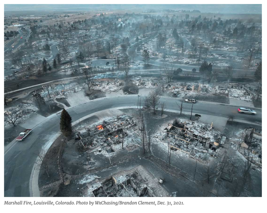
Authorities today ended their year-and-a-half-long investigation into the cause of the 2021 Marshall Fire, concluding that Colorado’s most destructive wildfire in history actually had two separate ignition sources, one of which was six days before the fire grew out of control, with the other later originating from arcing power lines.
Boulder County Sheriff Curtis Johnson said the fire was first set on December 24, 2021 to burn branches and construction debris at a religious group’s compound on El Dorado Springs Drive. According to a Colorado Public Radio (CPR) report, that fire was inspected by the local fire department, which determined the fire had been extinguished correctly. But high winds six days later on December 30 uncovered hot ashes and reignited the fire. About an hour later, sparks from an Xcel Energy power line started a second fire about 2,000 feet away.
Boulder District Attorney Michael Dougherty said no criminal charges would be filed against either Xcel or the Twelve Tribes group. “We make our decisions based on evidence,” he said, “and not based on emotion. If we were to tell you we were filing charges today, it would be wrong and unethical.”
The Denver Post reported that the Marshall Fire was Colorado’s costliest; it destroyed $2 billion in property and killed two people.
High winds, even with occasional hurricane-force gusts, are not unusual in this foothills region of Colorado, where the eastern prairies meet the Rockies. According to a climate.gov report, the Marshall Fire ripped through suburban neighborhoods on the west side of the metropolitan area. Pushed by high winds and fueled by dry conditions, the fire burned more than 6,000 acres, killed two people, and destroyed over 1,000 homes. On the day of the windstorm, atmospheric pressure dropped sharply east of the Rockies, and strong downslope winds followed. At the base of the foothills west of Denver, wind gusts reached 100 miles per hour.
Johnson and Dougherty spent more than an hour Thursday morning laying out details of their investigation and how Dougherty came to the conclusion that no criminal charges would be filed.
Investigators found no evidence that members of the Twelve Tribes organization intended to start the Marshall Fire — or that Xcel Energy was negligent in maintaining its equipment, Dougherty said.
The Twelve Tribes Community is classified by the Southern Poverty Law Center as a “Christian fundamentalist cult.” It has a local home in the foothills of the Rockies on Eldorado Springs Drive. “We gather every morning and evening to hear from our Creator through one another,” says the group’s website. “Devoted to the teachings and selfless life of our Master Yahshua the Messiah (Jesus of the Bible), we lay down our lives for one another (meeting each other’s needs first) to see His kingdom come to the earth. We work, rest, dance, laugh, and eat together as a family, enjoying one another’s fellowship.” The Denver Post published an in-depth look at the group a year ago.
At the request of the Colorado Division of Fire Prevention & Control, a Facilitated Learning Analysis on the fire was completed. The lengthy and detailed document is in a “storymap” format, which in this case includes many illustrations, photos, and maps.
Xcel, incidentally, is disputing the investigation’s findings, arguing that fires in underground coal deposits (not uncommon in Colorado) near their power lines may be responsible for the start of the second fire. “We strongly disagree with any suggestion that Xcel Energy’s power lines caused the second ignition, which according to the report started 80 to 110 feet away from Xcel Energy’s power lines in an area with underground coal fire activity,” said Xcel spokesman Tyler Bryant. “Xcel Energy did not have the opportunity to review and comment on the analyses relied on by the Sheriff’s Office and believes those analyses are flawed and their conclusions are incorrect.”


 High winds, even with occasional hurricane-force gusts, are not unusual in this foothills region of Colorado, where the eastern prairies meet the Rockies. According to a