Wildfire near Woodward, OK causes evacuations

(UPDATE at 12:48 p.m. CDT, May 7, 2014)

Woodward County Emergency manager Matt Lehenbauer reported on the Ready Woodward Facebook page that the wildfire northwest of Woodward, Oklahoma burned one home. Two people have been injured and were transported by aircraft. 

Mr. Lehenbauer said the fire is contained after burning 13,711 acres. National Guard Blackhawk helicopters dropped 45,000 gallons of water on the fire and were assisted by Aero-Flite’s water scooping CL-415 air tanker.

Resources assigned to the fire on Wednesday include two task forces with a total of
6 dozers, 6 engines and 2 Task Force Leaders, 1 Operations Specialist, 1 Air Attack Platform, 2 Single Engine Air Tankers, and 1 CL-415 water-scooping air tanker

Another fire earlier this week east of Woodward between Moorland and Quinlan is controlled after burning 14,100 acres.

KOCO has an article and photos of Aero-Flite’s brand new CL-415 water scooping air tanker (Tanker 260) that relocated from Florida to Oklahoma City to be used on the fires. Michelle Self posted a video on her Facebook page of it scooping out of Lake Liberty (map) while it was working on the fire near Guthrie, OK. The lake was five to ten miles west of the fire which would have contributed to very fast turnaround times for the 1,600 gallon water drops.

****

(Originally published at 5:43 p.m. CDT May 6, 2014)

Smoke from wildfire near Woodward, OK
Smoke from a wildfire near Woodward, OK was visible on radar at 5:25 p.m. CDT, May 6, 2014.

A wildfire northwest of Woodward, Oklahoma is spreading rapidly Tuesday afternoon, forcing residents to evacuate. The fire is between Woodward and Fort Supply.

Wildfire between Woodward and Fort Supply, OK
The red squares represent heat on a wildfire between Woodward and Fort Supply, OK at 3:31 p.m. CDT May 6, 2014. The heat was detected by a satellite.

The following was sent out Tuesday afternoon May 6 at 4:05 CDT:

THE FOLLOWING MESSAGE IS TRANSMITTED AT THE REQUEST OF THE WOODWARD AND HARPER COUNTY EMERGENCY MANAGEMENT.

A WILDFIRE WAS LOCATED FROM 4 MILES NORTHWEST OF WOODWARD NEAR HIGHWAY 270 AND EAST-WEST COUNTY ROAD 36… TO HIGHWAY 34 ONE MILE SOUTH OF THE HARPER COUNTY LINE. THIS WILDFIRE WAS MOVING RAPIDLY TOWARD THE NORTHEAST INTO FAR SOUTHEAST PORTIONS OF HARPER COUNTY. RESIDENTS IN THE PATH NEAR AND EAST OF HIGHWAY 34 SHOULD IMMEDIATELY EVACUATE TO THE SOUTH AND EAST.

PERSONS CAN GO TO THE WOODWARD PIONEER ROOM LOCATED AT 9TH AND OKLAHOMA IN WOODWARD.

At 3:31 p.m. CDT Tuesday the fire was approximately 11 miles long and at least 2 miles wide, spreading toward the northeast. It was moving from Woodward County into Harper County, according to Woodward County Emergency Management Director Matt Lehenbauer. The fire had been contained earlier in the day but began spreading again around 4:30 p.m., according to Mr. Lehenbauer.

Two National Guard Black Hawk helicopters are assisting firefighters on the ground.

The weather forecast for the rest of the afternoon in the fire area is for 91 degrees, a 28 mph wind out of the southwest gusting to 39 mph, and a relative humidity of 6 percent — conditions that are conducive to rapid fire spread. The wind should be decreasing Tuesday night by about 50 percent.


Oklahoma firefighter hit by exploding bullets

A volunteer firefighter was hit by exploding ammunition while fighting a wildfire near Guthrie, Oklahoma which had spread to a structure. Frank Megow is an Army and Marine Corp veteran, but probably didn’t expect to be hit by bullets while fighting a fire.

Below is an excerpt from an article at KOCO.com:

…“Rate of spread went to a full run, started hitting aerial fuels, we got overran by the fire, trucks got engulfed,” [Mr. Megow] told KOCO 5’s Kim Passoth.

Minutes before the fire overtook the home, Megow and his men from the Washington Volunteer Fire Department tried to save it, unaware of the hidden danger inside.
“Landowner that owns the house, he has five to six hand guns,” said a man who lived in [John] Trimberger’s home.

The fire’s heat started exploding the ammunition. “As we went to make entry in the structure that’s when the ammunition started cooking off,” said Megow. “I took two to the chest and one to the head,” he added…

Megow was hit by shrapnel. “Bullets, when they explode, it’s energy going both directions so that’s what pretty much saved me but I took a couple of hits,” Megow said.

Mr. Megow was eventually transported in an ambulance.

More information about the wildfire near Guthrie, Oklahoma.

Oklahoma: one person killed and six homes destroyed in wildfire

(UPDATED at 12:42 p.m. May 7, 2014)

The wildfire near Guthrie, Oklahoma burned approximately 3,250 acres. One
civilian fatality is attributed to this fire and an estimated 46 structures have been lost, according to Oklahoma Forestry Services (OFS). The fire has been turned back to local command with all containment lines holding through Tuesday’s weather conditions. OFS will have a Task Force with 3 dozers and 3 engines assisting with patrol and mop up on Wednesday.

****

(UPDATED at 11:57 a.m. CDT, May 6, 2014)

The wildfire near Guthrie, Oklahoma continued to be active on Monday due to strong winds and low relative humidity. The weather forecast for Tuesday is similar, predicting Red Flag conditions,  with 94 degrees, 23 percent relative humidity, and 24 mph winds gusting up to 33 mph. Tuesday morning the fire was reported to be 90 percent contained.

In the video below, Guthrie Fire Department Chief Eric Harlow provides an update on the fire. It was recorded May 5, probably late in the day, and was uploaded to YouTube on May 6. 

Despite earlier reports provided by fire officials, investigators with the Oklahoma state Department of Agriculture and the state Fire Marshall’s Office have found no evidence the fire started as a controlled burn.

****

(UPDATED at 7:15 p.m. CT, May 5, 2014)

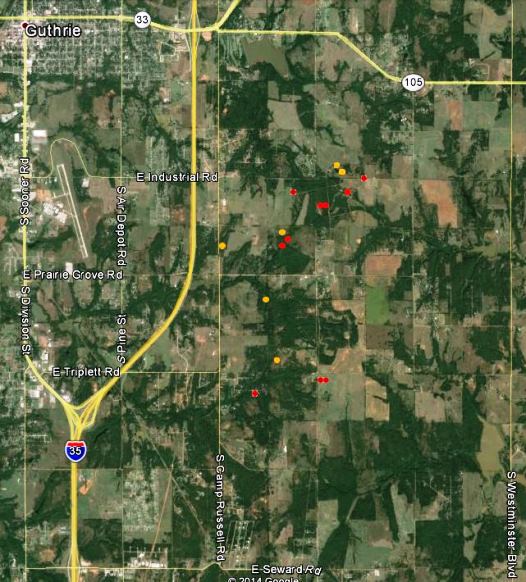
Map of fire near Guthrie, OK 250 pm CT May 5, 2014
Map of fire near Guthrie, OK, showing the approximate locations of heat detected by a satellite at 2:50 p.m. CT, May 5, 2014. The red and yellow dots represent the location of the heat.

The location of the fire is southeast of Guthrie, Oklahoma, 24 miles north of Oklahoma City, and east of Interstate 35 (map).

The local fire departments have not released information about the exact location of the origin of the fire, but they did say it started from a “controlled burn” — which could mean anything from a resident burning trash in their back yard, to a rancher burning a pasture. Google Earth did not show any indication that any federal land was in the area of the fire.

Fox23 in a Monday afternoon report said at least a dozen homes have burned and the estimated size of the fire is now 3,000 to 3,500 acres. National Guard Blackhawk helicopters worked the fire Monday.

From Fox23:

Gov. Mary Fallin visited the command post Monday, and said the US Forestry Services crews were creating fire lines and that she put in a request to get an air tanker flown to Guthrie from Arizona.

According to the Oklahoma Department of Emergency Management three National Guard Blackhawk helicopters, two single engine air tankers (SEATs), and “a Tanker 415” will be available Tuesday evening. The “Tanker 415” could be Tanker 260, Aero-Flite’s CL-415 that was reported by Wildfire Today reader Tom Wilson (in a comment below) to be relocating from Florida to Oklahoma City on Monday. Fire Aviation had an article about Tanker 260 in November.

According to state law the Oklahoma Division of Forestry is the operational lead for wildfire emergencies.

The video below, uploaded to YouTube about 3 p.m. on Monday, has views of the fire from an aircraft.


****

(Originally published at 11:52 a.m. CT, May 5, 2015)

Fire officials said a controlled burn near Guthrie, Oklahoma escaped on Sunday and killed one person and destroyed at least six homes. Guthrie Fire Department Chief Eric Harlow said the number of damaged homes was expected to rise after they are able to better assess the four to six square mile (2,560 to 3,840 acre) fire after sunrise on Monday. About 1,000 people evacuated on Sunday, but most of those have been able to return to their homes.

Chief Harlow said the 56-year old man who was killed had refused to evacuate when requested by his family and law enforcement.

On Sunday the fire was pushed by strong winds and dry conditions. The weather forecast for the Guthrie area on Monday calls for similar weather — 100 degrees, 17 to 20 mph southeast winds gusting to 28 mph, and single-digit relative humidities.

Early Monday morning Chief Harlow said:

We still have some hot spots but for the most part we do have control of this thing. I’m still going to say 75 percent containment. Three of the four sides are contained. The north side I’m not going to say is 100 percent contained yet.

He said the fire started from a controlled burn on one of two properties, but did not know exactly what the land owner had initially intended to burn.

They have requested helicopters from the National  Guard which would arrive at 11 a.m. at the earliest.

The video below is a recording of a live media briefing early Monday morning featuring Chief Harlow.

The cost of prescribed fire in Oklahoma

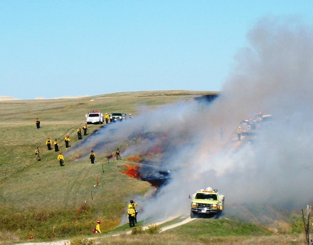
Black lining on the Dillon Prescribed fire
Black lining on the Dillon Prescribed fire at Badlands National Park in South Dakota, October 10, 2002. NPS photo by Bill Gabbert.

The Noble Foundation kept track of the costs of conducting prescribed fires in 1996 on the Noble Foundation D. Joyce Coffey Resource and Demonstration Ranch west of Marietta, Oklahoma. A report they prepared also took into account the costs of burning on properties belonging to Terry Stuart Forst, a Noble Foundation cooperator. The lands have a variety of topographical features and plant communities from which to evaluate the costs and effects of prescribed fires.

The costs per acre listed below are from activities in 1996, so an adjustment will have to be made to consider them in current day dollars. According to The Inflation Calculator, the difference between 1996 dollars and 2013 costs is plus 46 to 67 percent.

  • Timber, Coffey Ranch: $4.64/acre
  • Grassland, Stuart Ranch: $0.23/acre
  • Timber/grassland, Stuart Ranch: $0.35/acre

Wildfire briefing, February 27, 2014

Dynamic Aviation Citation lead plane
Dynamic Aviation’s Citation CJ lead plane. Photo courtesy of Dynamic Aviation.

BLM awards contract for first jet-powered lead plane

The Bureau of Land Management has awarded a contract for the first jet-powered lead plane in the United States. Lead planes fly ahead of the much larger air tankers that drop retardant on fires. They identify the targets and evaluate the fire and wind conditions. Dynamic Aviation, with headquarters in Bridgewater, Virginia, will be supplying a Cessna Citation CJ to serve as a lead plane and Air Supervision Module (ASM) this fire season. With the jet-powered air tankers now in use, including DC-10s, BAe-146s, and MD-87s, there is a need for a lead plane that can keep up with the “next-generation” air tankers.

(More information is at Fire Aviation.)

Evacuations ordered in southern California fire areas before storm

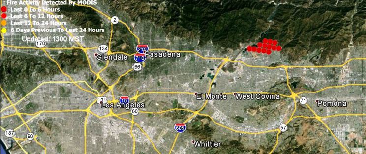
Mandatory evacuations have been ordered for about 1,000 homes that could be affected by debris flows out of recent wildfires in the Glendora and Azusa areas. The Colby Fire burned 1,952 acres of the hillsides above the communities on January 16, 2014.

Weather forecasters have predicted several inches of rain for some areas in southern California between Thursday and Saturday.

Map showing the approximate location of the Colby Fire at 10:37 a.m. PST, January 16, 2014
Map showing (in red) the approximate location of the Colby Fire at 10:37 a.m. PST, January 16, 2014. (click to enlarge)

“Ice makes a good firebreak”

From The Nature Conservancy, describing a prescribed fire in Oklahoma:

Crews use drip torches to start the 475-acre controlled burn at the Four Canyon Preserve

“We took advantage of a break in the weather on February 1 and completed a 475-acre prescribed burn at the Four Canyon Preserve. This work was funded by a ConocoPhillips and National Fish and Wildlife Foundation grant, and it wouldn’t have been possible without their help,” said Chris Hise, Four Canyon Preserve Manager. “It’s very early in the season to be burning here, but we’re trying to stay ahead of a worsening drought situation. I had the odd experience of carrying a drip torch along the frozen banks of the Canadian River. Ice makes a good firebreak.”

More info, and photos, are at The Nature Conservancy’s website.

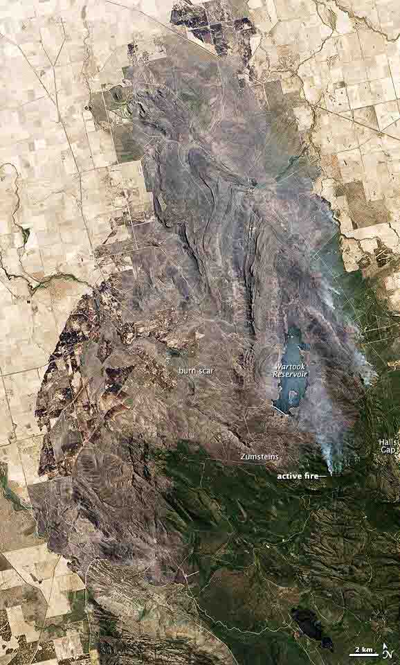
NASA photograph of a fire in Australia

A large fire burning in and around Grampians National Park in Victoria, Australia, was nearly contained when the Operational Land Imager on the Landsat 8 satellite acquired this image on January 19, 2014. The burned land is gray-brown in this natural-color image. Active fires were burning on the east side of the burn area, sending up plumes of smoke.

Bushfire in Grampians NP, Victoria, Australia
Bushfire in Grampians NP, Victoria, Australia. NASA photo.

Oklahoma: 35 mph winds challenge firefighters in Craig County

News9.com – Oklahoma City, OK – News, Weather, Video and Sports |

News9 has some excellent footage of fire engines attacking grass fires in Craig County, Oklahoma on Thursday. Firefighters are appreciating some wet weather today, but yesterday a fire burned 800 acres and destroyed a barn. Wind gusting up to 35 mph challenged firefighters from more than 20 departments to contain the fire that was three miles long and a half mile wide. According to reports the fire jumped two county roads and a state highway.

Map of multiple tornado paths in Moore, Oklahoma

(Originally published at 4:09 p.m. CT, May 21, 2013; see update below, May 22)

No doubt you have heard about the massive and very tragic tornado that devastated large sections of Moore, Oklahoma Monday. Our sincere condolences go out to those that are affected by the loss of life and property.

ESRI has put together the map below which not only shows the path of Monday’s tornado, but you can configure it to also show the paths of the two tornadoes that went through the town in 1999 and 2003 — click on “Layers”, then check the boxes. You may need to zoom out to see all three of them. (All three tornado paths may not display perfectly with Internet Explorer or a mobile device.)

Response of land management agencies and wildland firefighters

We are not aware of any large numbers of widland firefighters or Federal/State interagency incident management teams being assigned. If that changes, we’ll update this area in the article.

UPDATE at 8:58 a.m. CT, May 22, 2013:

There is still no word of large numbers of wildland firefighters or land management agency personnel being assigned to the incident. But here is what FEMA is mobilizing, as of 5:11 p.m. May 21:

  • Preliminary damage assessment teams, comprised of representatives from the state, FEMA and the Small Business Administration, are on the ground and will begin assessments today, and more counties and additional forms of assistance may be designated after the assessments are fully completed.
  • Three national Urban Search and Rescue Teams (Texas Task Force 1, Nebraska Task Force 1 and Tennessee Task Force 1) and an Incident Support Team have been deployed to support the immediate response efforts.
  • One national and two regional Incident Management Assistance Teams are deployed to the state emergency operations center in Oklahoma City to coordinate with state and local officials in support of recovery operations.
  • Two Mobile Emergency Response Support Teams are in Oklahoma to provide self-sustaining telecommunications, logistics, and operations support elements, to assist in the immediate response needs and additional teams are being deployed.
  • Three Disaster Survivor Assistance Teams are scheduled to arrive later today into communities to perform the Assess, Inform, and Report (AIR) Missions, a tool to help federal, state, local, tribal and territorial partners gather detailed information on the affected areas during the critical first hours, days and weeks after a disaster strikes. DSATs will address immediate and emerging needs of disaster survivors including: on-site registration, applicant status checks, on-the-spot needs assessments, and access to partners offering survivor services.
  • FEMA activated the National Response Coordination Center in Washington, D.C., a multi-agency coordination center that provides overall coordination of the federal response to natural disasters and emergencies, to support state requests for assistance, and FEMA’s Region VI Response Coordination Centers (RRCC) located in Denton, Texas remains activated.

UPDATE at 4:43 p.m. CT, May 21, 2013: 

The National Park Service has two two Search and Rescue Liaison Officers assigned. One liaison is working with FEMA at the ESF#9 cell in DC, the other is deployed with the FEMA IST in Moore, OK. NPS has one FEMA Mission Assignment for SAR coordination and planning. The primary focus is on urban and wide-area search and rescue. All forces are still working in a “rescue” posture.

Information from FEMA

Below is information from FEMA about their response as of 5:30 a.m. ET Tuesday:

****

“In response, the Oklahoma EOC fully activated to Level I and the President declared Major Disaster Declaration FEMA-4117-DR for the State of Oklahoma.

FEMA Region VI RRCC is activated to Level II, with a regional IMAT and LNOs deployed to Oklahoma’s SEOC. Additionally, the Regional Administrator remains in contact with State officialsTwo (2) Individual Assistance (IA), Preliminary Damage Assessment (PDA)Teams arrived at 1:15 a.m. EDT, May 21, 2013. Denton MERS is deploying one (1) mobile emergency operations vehicle (MEOV) and one (1) initial response vehicle (IRV).

FEMA’s NRCC is activated to Level II (w/ESFs, 1-3, 6-9, 15 and all LNOs). National IMAT-White is activated and deploying to Oklahoma. FEMA Logistics ADVON and Main Body ISB personnel and ISB equipment cache will deploy to Will Roger Airport (Haggar Facility), Oklahoma City, OK. Urban Search and Rescue Task Task Forces TX-TF1, NE-TF1 & TN-TF1 are activated/deploying to Will Roger Airport (Haggar Facility), Oklahoma City, OK.”

Fire contractor interviewed on CNN about sequestration

Choleta Fire on CNN

Choleta Fire on CNN

Mark Masters, the CEO of Chloeta Fire, sent us some photos taken of a live interview they did with CNN Wednesday regarding the effects that sequestration may have on wildland fire management. Mr. Masters is a former rappeller, Fire Management Officer, dispatcher, and National Interagency Fire Center employee now running the fire contracting company in Oklahoma.

Choleta Fire on CNN Choleta Fire on CNN