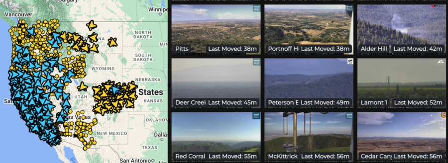
Remote fire sensors deployed on Hawaiian islands

Fire detection sensors are being set up around Maui and other Hawaiian islands to allow local resources to respond faster when wildfires break out, said Governor Josh Green today.

CNN reports that Maui Mayor Richard Bissen added, “The introduction of an early detection system will give our first responders a critical advantage in protecting our community. With this new technology, detecting fires at the very early phases will save lives.”

According to MauiNow, the remote sensors are en route to Kīhei and Lahaina, and they will use a combination of thermal imaging, gas detection, and Artificial Intelligence (AI) algorithms; the wildfire sensors detect concentrations or spikes in particulates or carbon monoxide to identify wildfire ignition — in real time. The sensors transmit data by email or text notifications to pre-set contacts, and the remote units are small enough for installation on utility poles or traffic lights. They can also work in all weather conditions, according to the U.S. Department of Homeland Security.

“What’s important is we get to the scene as fast as we can, so that we can catch fire in incipient phases,” said Maui Fire Chief Brad Ventura. “Today we share one more tool that’s going to help expedite our responses to our communities.”

About 80 fire sensors are being set up around the islands; the first 20 on Maui are planned for deployment by the first week of April.

These sensors detect heat and also can track anomalies such as airborne smoke particles and gases produced by fires — and can distinguish those from other substances common in the air around Hawai’i — including volcanic ash and ocean salt.

~ Thanks and a tip of the hardhat to Rick for this. 

$11 million contest for innovation in fighting fire

Best-selling author and futurist Peter Diamandis became frustrated in recent years with the “craziness” of constant wildfire alerts he’d received. But unlike most people, Diamandis has a Rolodex full of wealthy benefactors and politicians, along with experience with a solution he had used before: Create a contest.

On April 21 his group XPRIZE launched its latest contest: finding new ideas to detect and suppress wildfires.

Pacific Gas & Electric (PG&E) said the prize threshold includes detecting and suppressing a high-risk wildfire in 10 minutes or less, and pinpointing from space all fire ignitions across multiple states or countries — in 60 seconds. These are the challenges for innovators in XPRIZE Wildfire, a four-year, $11 million competition to develop and demonstrate fully autonomous capabilities to find and fight wildfires.

XPRIZE Wildfire

The United Nations, the White House, and Congress recently have prioritized destructive wildfires as a major economic, environmental, and safety threat. Patti Poppe, CEO of PG&E, said they are co-sponsoring the project. “Today’s launch of XPRIZE Wildfire is a call-to-action to entrepreneurs, roboticists, artificial-intelligence experts, scientists, and innovators from across the globe to revolutionize wildfire detection and suppression,” she said.

XPRIZE Wildfire encourages teams from around the world to innovate across firefighting technologies in two different tracks designed to transform how fires are detected and suppressed.

    • In the Autonomous Wildfire Response track, teams will need to monitor at least 1,000 square kilometers (386 square miles), and autonomously suppress a wildfire within 10 minutes of detection.
    • In the Space-Based Wildfire Detection & Intelligence track, teams will have one minute to accurately detect all fires across a landscape larger than entire states or countries, and 10 minutes to precisely characterize and report data (with the fewest false positives) to two ground stations.

The day before something is a breakthrough, it's a crazy idea.

The Los Angeles Times reported that Palmer Luckey, a 30-year-old founder of Oculus, a virtual reality company that sold for $2 billion, announced that he was forming the first team to compete for the prize. He said he cares more about solving the problem than winning the money, but he believes the cash will motivate other contestants to form teams and compete.

“I sold my last company for billions of dollars so I can do whatever I want,” he said. “We started working on wildfire tech because I think it’s very, very important. The money in this prize to me is honestly immaterial.” Luckey said at the contest launch that he thinks software, not hardware, will make the difference in detecting and containing fires.

The four-year contest is not winner-take-all. Teams will compete for top prizes of as much as $3.5 million and a bonus $1 million prize to develop technology that can detect fires both from the ground and from space, and fight them using drones or other autonomous vehicles. They’ll compete, for example, to see which technology can accurately detect fires across a land mass the size of a state or country in one minute or suppress fires using an autonomous vehicle within 10 minutes.

Andrea Santy, who is running the competition for XPrize, also said the prize money may not be the most important driver. Teams will benefit from multiple rounds of live testing and validation that would be hard to organize independently. The group is spending an additional $11 million beyond the prize money to run the contest, she said; some of that money will fund a documentary about the competition.

XPRIZE Wildfire is offered in partnership with Co-Sponsors PG&E and Gordon and Betty Moore Foundation, Presenting Sponsor Minderoo Foundation, Bonus Prize Sponsor Lockheed Martin, Supporting Sponsor Conrad N. Hilton Foundation, and Benefactors Nichola Eliovits and Michael Antonov. Sixteen teams are already registered. For more information, to get involved, or to register a team to compete, visit the xprize.org/wildfire website.

PG&E launches satellite wildfire alert system

PG&E fire detection and alert system
PG&E fire detection and alert system. PG&E illustration.

The following information was released by the California-based Pacific Gas and Electric Company which describes a system they have developed to extract near real time fire detection data from satellites, such as the GOES 16 and the new GOES 17. Scott Strenfel, a Senior Meteorologist at PG&E, said   they are planning to make the data public within a month or two, which may be the first public tool available with GOES-R fire detections.


SAN FRANCISCO –– After several years of testing and development, Pacific Gas and Electric Company (PG&E) has deployed the PG&E Satellite Fire Detection and Alerting System.

The Satellite Fire Detection and Alerting System is a state-of-the-science program that incorporates data from the two new GOES satellites, as well as three polar orbiting satellites, to provide PG&E with advanced warning 24/7 of potential new fire incidents. The satellites are operated by the United States’ National Oceanic and Atmospheric Administration (NOAA)’s National Environmental Satellite, Data, and Information Service division.

“This capability offers first-of-its-kind situational awareness by providing a live feed from the satellites to our Wildfire Safety Operations Center. Emerging technologies such as this are another way we are working to reduce wildfire risk and protect our customers and our communities,” said Sumeet Singh, Vice President of PG&E’s Community Wildfire Safety Program.

The PG&E Meteorology Team led development of the program in collaboration with experts in the satellite fire detection field from the University of Wisconsin–Madison Space Science and Engineering Center (SSEC). The system became fully operational in late June.

PG&E fire detection and alert system
PG&E fire detection and alert system.

Working with the SSEC, PG&E developed a dedicated and proprietary data pipeline that provides fire detection data as fast as every minute. An internal web application allows staff at PG&E’s Wildfire Safety Operations Center to track fire progression as well as the intensity of fires in near real time. The system also generates new fire alerts via email and on an app. The system has already detected hundreds of fires since it began limited operation in February.

If a fire is detected from two or more satellites, such as GOES-16 and 17, then confidence is high of an actual fire in the area. In many cases this system is expected to provide an early, if not the first, indication of an incident.

Community Wildfire Safety Program

By the end of 2019, PG&E plans to have at least 600 weather stations and 100 high-definition cameras in high fire-threat areas. These new installations are one of the additional precautionary measures the company is implementing following the 2017 and 2018 wildfires to further reduce wildfire risks.

40 fire wildfire detection cameras to be install in the North Bay

The cameras can spot a fire soon after it ignites.

FireAlert camera
Technicians install an AlertWildfire camera. File photo from the University of Nevada.

Several organizations are cooperating to install a network of cameras in the North Bay area of California that can detect wildfires soon after they start. At a perfect location with a 360° view the near infrared sensors can spot the signature of heat on up to 5,000 square miles, and up to 20,000 square miles at night. If a second camera detects the same heat source or smoke, the triangulation can tell dispatchers the exact location, enabling firefighters to get to the scene quickly.

A supercomputer attached to the network can then model the fire’s spread in 30 seconds to predict where it will be burning in the next several hours.

Recently one of the $2,600 cameras was installed on a hill that overlooks the path of the deadly Tubbs fire that burned into Santa Rosa in 2017.

Below is an excerpt from the Press Democrat:

With support from PG&E, the network plans to cover Sonoma, Mendocino, Napa, Lake and Marin counties with up to 40 such cameras by the end of March.

Thirteen of the pan-tilt-zoom cameras are already operating in the North Bay, with their images available to emergency dispatchers and to the public at alertwildfire.org.

The broader goal is to establish 200 new cameras statewide this year and Gov. Gavin Newsom’s budget includes funding for 100 more, said Graham Kent, director of the seismological laboratory at the University of Nevada, Reno, that started the program.

The Sonoma County Water Agency is also supporting the camera installation project.

The AlertWildfire group, a consortium of universities, including Scripps Institution of Oceanography at UC San Diego, Sonoma State University, and Oregon State University will build and maintain the system.

“These cameras will provide us with early fire detection and a level of situational awareness that is critical as we adapt to new wildfire behavior,” Sonoma County Water Agency director and Board of Supervisors Chair James Gore said.

The fire-camera system is built to the specifications of the University of Nevada, Reno’s Seismological Lab’s earthquake monitoring communications network based in their College of Science. It features private high-speed internet connectivity capable of transmitting seismic, environmental and climate data, in addition to the live-streaming high-definition video from the fire cameras.

“These fire camera networks realize their full functionality when a cluster of cameras are deployed in one area and to supply early detection, 911 confirmation, and situational awareness as well as triangulation to locate the fires,” Neal Driscoll, a professor at UC San Diego and co-leader of AlertWildfire, said. “Sonoma County Water Agency’s vision has made the North Bay region the next fire camera cluster.”

map AlertWildfire system
The dots represent the locations of fire detecting cameras in the AlertWildfire system.

Dozens of cameras are already installed and working in Southern California, the Lake Tahoe area, and locations in Nevada.

NASA to launch 200 satellites that will detect wildfires

CubeSat
CubeSat. NASA photo.

The National Aeronautics and Space Administration plans to launch a network of 200 small satellites that will detect wildfires within 15 minutes after a blaze grows to be at least 35 to 50 feet across. NASA’s Jet Propulsion Laboratory is working on a concept for a network of space-based sensors called FireSat in collaboration with Quadra Pi R2E. Within three minutes of detecting a fire from orbit, FireSat would notify emergency responders in the area of the fire.

Robert Staehle, lead designer of FireSat at JPL, and his team first presented the concept of FireSat in 2011 to the joint NASA/U.S. Forest Service Tactical Fire Remote Sensing Advisory Committee. They spent the subsequent years refining their understanding of fire monitoring needs and technological requirements.

“Such a system has only now become feasible at a reasonable cost, enabled by advances in commercial microelectronics that NASA, JPL and universities have tested in space via CubeSat experiments, and by software technology originally developed to give Mars rovers and Earth orbiters more autonomy in their science observations,” Staehle said.

This sounds like science fiction, but launches should begin in 2017 with a fully operational system of FireSat sensors in space by June of 2018.

CubeSats are 4 inches by 4 inches by 4 inches and weigh about 3 pounds. They are generally built from off the shelf components at a cost of thousands rather than millions of dollars.