
One was on the Miles Fire in Oregon and the other was on the Ferguson Fire in California
Continue readingWatson Creek Fire spreads to within 6 miles of Paisley, Oregon

The fire has burned 32,104 acres
Continue readingFires grow in Oregon and Northern California

Above: This natural-color satellite image was collected on July 18, 2018. Actively burning areas, detected by thermal bands, are outlined in red. NASA image courtesy NASA/Goddard Space Flight Center Earth Science Data and Information System (ESDIS) project.
By Lynn Jenner, NASA
In Oregon there are 15 large ongoing fires and 231,278 acres have been burned as of August 20, 2018. The satellite image above shows several of the larger fires in both Oregon as well as California. California has 10 large fires including the two largest to date, the Ferguson fire and the Mendocino Complex. California has seen 716,276 acres burned this year.
In Oregon, the Taylor Creek and Klondike Fires are burning in the Rogue River-Siskiyou National Forest. Both fires were started by lightning on July 15. These two fires were split into zones on Saturday, Aug. 18. The fires are now referred to as “Taylor Creek and Klondike East Fires,” managed by the Alaska Incident Management Team and the “Klondike West Fire” which is managed by California Interagency Incident Management Team 4. California Interagency was called in to continue with the aggressive fight to fully suppress the fire. That will allow the Alaska Incident Management Team to focus its effort on controlling the southeast corner of the fire that is directly threatening the communities of Selma and Cave Junction. As of the morning of Aug. 20, the Taylor Creek Fire is estimated 52,588 acres and is 79 percent contained. The Klondike Fire is estimated at 72,074 acres and is 28 percent contained.
The Miles Fire is the new name for the fire previously named the Sugar Pine. The Miles Fire and Sugar Pine fire have merged. On Sunday July 15, lightning started hundreds of fires across Southwest Oregon. The Miles fire has currently affected 47,015 and is 38% contained at present. Today some instability will swing into the area with the threat of some isolated showers or a thunderstorm. Continued smoke in the valleys will moderate daytime temperatures but will also continue to affect air quality for local communities.
The Watson Creek fire is currently burning on the Paisley Ranger District of the Fremont-Winema National Forest. It was discovered Wednesday, August 15 at 2:15 p.m. The fire is currently burning in heavy fuels, primarily dead and down lodge pole pine. This fire has burned 25,778 acres. The cause of the blaze is under investigation.
In California, right on the Oregon/California line between Happy Camp, CA and Cave Junction, OR is the Natchez fire which has been burning since lightning struck on July 15, 2018. The 697 personnel assigned to the incident are working to implement suppression actions that will most effectively and safely limit fire growth. Currently 20,275 acres have burned and the fire is 70% contained. Fire area closures are in place on the Rogue River-Siskiyou and Klamath National Forests.
The Stone fire began on August 15 with a lightning strike. The current fire size 22,610 acres. Weather concerns for this fire include extremely dry conditions and low humidity. The fire was active last night and fire crews made great progress along the fire edge to control the fire spread and provide structure defense.
Drone damaged during landing after surveilling fire
On August 7, 2018 while attempting a landing at the end of a mission on the Graves Fire in Oregon, an Insitu ScanEagle X200 unmanned aircraft came in too low resulting in a low capture on the suspended rope. The payload and the left wing sustained visible damage.
According to the preliminary report, the flight crew believes the failure of the aircraft to correct the errant glide path was caused by turbulence generated by terrain at the recovery site.
After the incident the ground control software was upgraded to improve the glide path tracking. In addition, the site lead reemphasized the decision making process for initiating a timely go-around.
An article by Gareth Corfield in The Register describes how a newer model of the aircraft, an Insitu ScanEagle3, is recovered after a mission:
“Insitu craft are recovered from the air by the simple process of commanding them to fly at a rope suspended from a crane-type contraption fitted with a hydraulic damper system;
 Photo by Insitu on Instagram of the recovery system as used on the Eagle Creek Fire in the Columbia River Gorge in September, 2017.
the aircraft’s swept wings are both fitted with titanium carabiners at their tips that grip the rope tightly, suspending the Scaneagle in mid-air until the ground crew lowers it. An onboard accelerometer senses the violent yaw when the wing is caught by the rope (the aircraft cartwheels sideways when it hits) and cuts the engine. The process was described as “very dynamic” by Insitu personnel, an assessment El Reg agreed with.
“The unmanned aircraft flies itself autonomously to the point where it returns back to its Skyhook (Insitu’s trade name for the crane-rope capture affair) using differential GPS with the ground beacon being placed under the rope. All human involvement is limited to pressing the required buttons to start the landing sequence and getting the UAV off the rope afterwards. Though the craft can be flown on barometric altitude (as manned aircraft typically use), it is launched and recovered on GPS altitude. We were told that the UAV is programmed to approach the rope at a height of 33 feet with a two-foot lateral offset to increase the chances of a wing meeting the rope rather than the nose.”
Drone used to ignite burnout operations on Klondike Fire in Oregon
 File photo of drone being used for the first time to ignite a prescribed fire at Homestead National Monument, April 22, 2016. Photo by Bill Gabbert.
April 22, 2016 was the first time that a drone, or Unmanned Aerial System, was used to intentionally ignite a managed fire. The University of Nebraska tested a system that had been under development, using it to ignite a portion of a prescribed fire at Homestead National Monument west of Beatrice, Nebraska. As a proof of concept, it was considered a success. The drone dropped plastic spheres which burst into flame about half a minute after landing on the ground, similar to the ones dropped by helicopters for aerial ignition on large wildfires and prescribed fires.
Using the technology developed by the University of Nebraska, drones are being used to help firefighters conduct firing operations on the Klondike Fire about 25 miles southwest of Grants Pass, Oregon.
Daily updates released by the incident management team between August 8 and 13, 2018 documented the use of the drones for lighting strategic fires to even out and increase the depth of burned areas adjacent to fire lines in difficult terrain where firefighter safety could be compromised. Firefighters say drone technology used on the Klondike Fire has enabled aerial observation and firing operations to continue during smoky conditions, which aids fire containment and completion of contingency lines.
The video below from the Mail Tribune has an interview with Steve Stroud, fleet manager with the Office of Aviation Services, explaining how the aircraft is used. An article at the site has more information.
The next video was filmed in 2016 at the first test of a drone to ignite a prescribed fire.
Thanks and a tip of the hat go out to Kelly.
Typos or errors, report them HERE.
 File photo of the drone used at the 2016 test at Homestead National Monument. Photo by Bill Gabbert.
Thanks and a tip of the hat go out to Kelly.
Typos or errors, report them HERE.
Update on Southwest Oregon fires

Here is a VERY brief update on the wildfires burning in Southwest Oregon.
On the map above the red dots are the most recent, representing heat detected by a satellite at 3:31 a.m. PDT July 28, 2018.
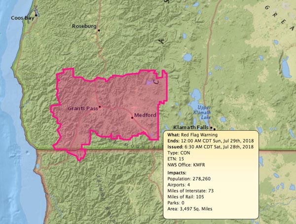
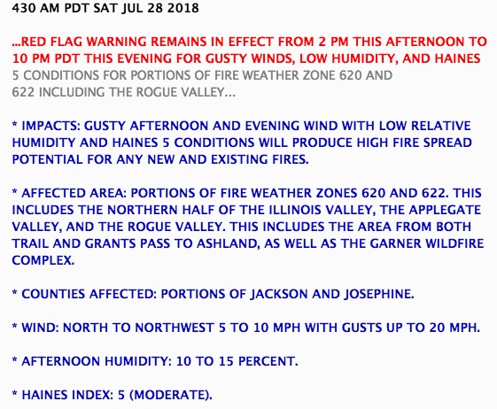
The area around Bend and Medford is under a Red Flag Warning Saturday for low relative humidity, gusty winds, and unstable atmospheric conditions.
Fires in Southwest Oregon were very active Sunday

Above: The map of Southwest Oregon shows heat on wildfires detected within the last week. The red dots are the most current.
(Originally published at 10 a.m. PDT July 23, 2018)
Firefighters in Southwest Oregon are still battling wildfires ignited by the lighting storms that passed across the state a week ago. The good news is they got a reprieve Sunday when additional lightning that was predicted didn’t show up.
Here is a brief summary of the fire situation in Oregon prepared by the Northwest Coordination Center Monday morning:
The warming and drying trend in Oregon will continue [Monday]. This trend is moving north into Washington. Smoke covered the Southwest Oregon fires through the morning [Sunday] and cleared out by early afternoon. As the smoke cleared, large fires in Southwest Oregon exhibited more active growth through the afternoon and into the evening.
Four Incident Management Teams are prepositioned in the Geographic Area and ready for assignments if needed: NW Team 7 (Knerr), NW Team 8 (Johnson), NW Team 10 (Lawson), and PNW Team 2 (Schulte).
The Garner Complex consists of six fires east of Cave Junction. Together they have burned over 11,000 acres. Sunday 50 Oregon National Guard personnel arrived to staff ten road blocks around the clock.
The 1,200-acre Timber Crater 6 Fire in Crater Lake National Park is one of several fires ignited by lightning in and around the Park July 15. On Monday the Incident Management Team described their situation:
With the number of new fires in the Northwest this week, firefighting resources are strained. However, the Timber Crater 6 Fire is being aggressively managed for full suppression, commensurate with values at risk and the overriding objective of public and firefighter safety.
Interesting pattern of wildfires in Southwest Oregon
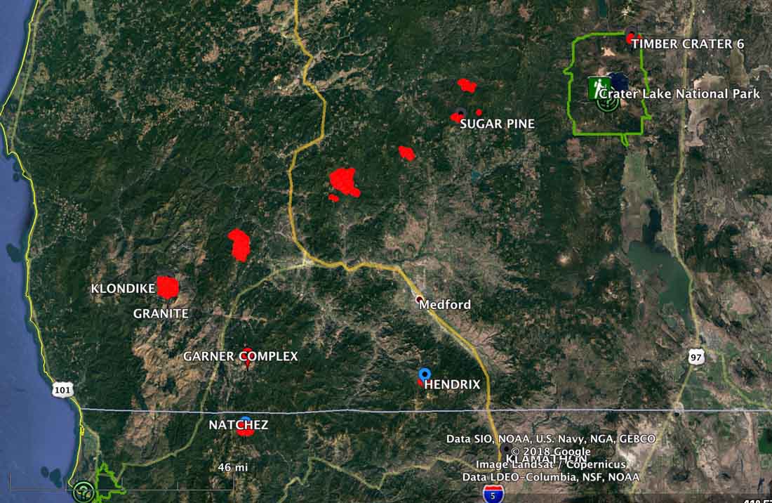
These fires in Southwest Oregon are arrayed in an interesting pattern. Most if not all of them I believe were caused by some of the 2,800 lightning strikes in the state last weekend. It makes you wonder if they were generated by an intense thunderstorm cell that moved northeast across that part of the state.
The red dots represent heat detected by a satellite at 3:59 a.m. PDT Saturday July 21.
United States and Canada share firefighting resources

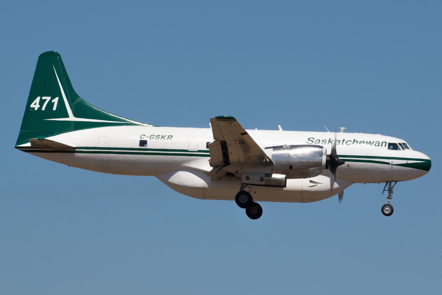
Above: Saskatchewan air tanker 474 lands at Medford, Oregon July 19, 2018.
Tim Crippin shot these photos of firefighting aircraft arriving at the Medford, Oregon airport July 19. The two air tankers and the Bird Dog aircraft are owned by the government of Saskatchewan. The planes were mobilized through the Pacific Northwest Compact to Oregon; it was not an action that was taken by the National Interagency Coordination Center (NICC).
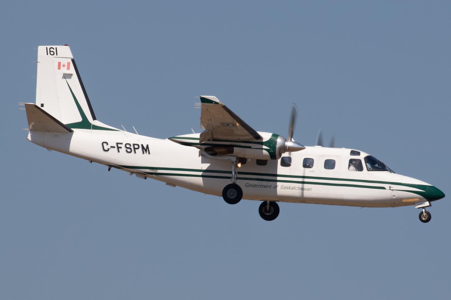
The Canadians use “Bird Dog” aircraft in a role similar to lead planes in the United States. A Bird Dog usually works with two air tankers as a three-aircraft module. This one, 161, is an Aero Commander 690D.
In addition to these three aircraft, other firefighting resources have been flowing across the international boundary in recent weeks from the U.S. to Canada:
- NICC dispatched 12 wildland federal firefighters to Ontario, Canada.
- The Northeast Compact sent resources to Ontario including three Type 2IA crews from New Hampshire, Maine and Massachusetts. However, the New Hampshire and Maine crews were demobed earlier this week and the Massachusetts crew will be demobed on Sunday.
- Maine will be sending a second Type 2 IA crew to Ontario on Saturday.
- The Great Lakes Compact has sent to Ontario 10 single resources (2 aviation managers and eight firefighters).
- Wisconsin State will be mobilizing eight firefighters also to Ontario, Canada.
No aircraft have been sent to Canada from the U.S.
One dead, 50,000 acres burn in Substation Fire

Northern Oregon southeast of The Dalles
Continue reading