
NIFC’s prediction for March and April
Continue readingSouthern California could see elevated wildfire danger in April & May
NIFC issues updated report on wildfire potential
Continue readingPotential for wildfires in California predicted to be high in November
It will remain high in southern California through December
Continue readingCalifornia and the Southeast expected to have above normal wildfire activity
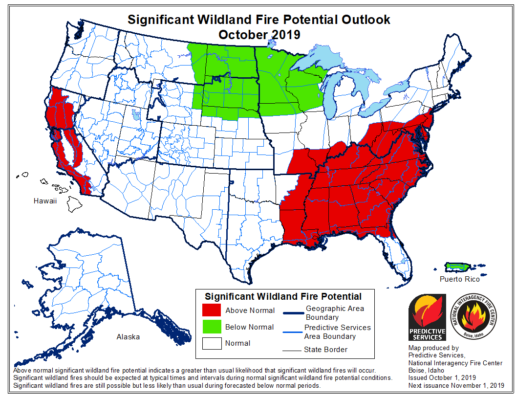 On October 1 the Predictive Services section at the National Interagency Fire Center issued their Wildland Fire Potential Outlook for October through January. The data represents the cumulative forecasts of the ten Geographic Area Predictive Services Units and the National Predictive Services Unit.
If NIFC’s analysis is correct, the Southeastern United States and areas of California will have areas with above average potential for wildfires through December.
Below:
- An excerpt from the NIFC narrative report for the next several months;
- More of NIFC’s monthly graphical outlooks;
- NOAA’s three-month temperature and precipitation forecasts;
- Drought Monitor;
- Vegetation greenness map;
- Keetch-Byram Drought Index.
From NIFC:
“Both [California and the Southeast] appear to have areas of elevated large fire potential entering the fall, especially across the Southeast where drought is emerging in the Appalachians. In California, fuels remain receptive to fire activity under critical fire weather conditions in the middle and lower elevations. The grass crop remains dense. This should remain a concern heading through October, November, and into December. In the Southeast, the persisting dry conditions will allow for the fuels to continue to dry which will allow for the large fire potential to continue to gradually elevate until the frequency of passing weather systems begin to increase in December and January.”
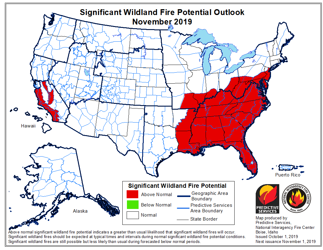

Portions of California expected to see above average wildfire activity
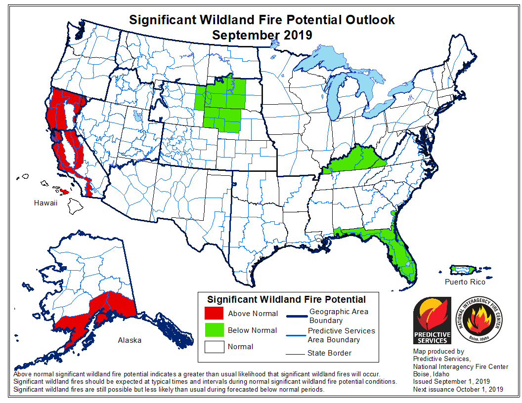
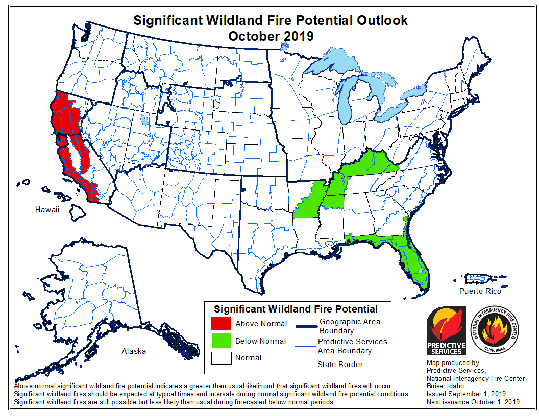
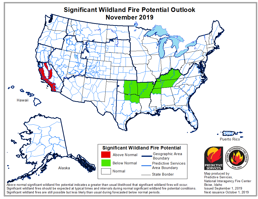
On September 1 the Predictive Services section at the National Interagency Fire Center issued their Wildland Fire Potential Outlook for September through December. The data represents the cumulative forecasts of the ten Geographic Area Predictive Services Units and the National Predictive Services Unit.
If NIFC’s analysis is correct, California will be one of two states expected to have areas with above average potential for wildfires, and those sections of California will shrink through December until the only areas remaining are the mountains and coasts from Santa Barbara south to the Mexican border. Southern Alaska could also have above normal fire activity in September.
Below:
- An excerpt from the NIFC narrative report for the next several months;
- More of NIFC’s monthly graphical outlooks;
- NOAA’s three-month temperature and precipitation forecasts;
- Drought Monitor;
- Vegetation greenness map;
- Keetch-Byram Drought Index.
From NIFC:
“Due to the recent lack of rainfall, areas of concern have emerged and are expanding to include Texas, California, Nevada, Utah and southwestern Wyoming – all of which have generally seen less than 25% of average precipitation during the past month. Extended periods of dry conditions across New Mexico and the southern Great Plains are also leading to the development and intensification of drought conditions.
“Entering September, warmer and drier than average conditions are expected to occur along the West Coast, which may persist well into fall. However, the passage of periodic wet systems should gradually end the fire season from north to south across the Northern Rockies, Central Rockies and Great Basin. Texas is expected to remain warmer and drier than average, which may, in turn prolong their season well into fall. Warmer and drier than average conditions are expected across the piedmont of the southern Appalachians, but wet antecedent conditions should preclude fire activity there.
“As the fall progresses, fire activity should relent over the Pacific Northwest and eventually Northern California during October. Southern California will likely be the last area to see fire activity conclude in 2019 as offshore winds and dry fuels may keep fire activity going south of Pt. Conception into December. In Alaska, overall warmer and wetter than average conditions are expected until the state enters winter.”
Elevated wildfire potential expected in Washington, Oregon, Nevada, and California
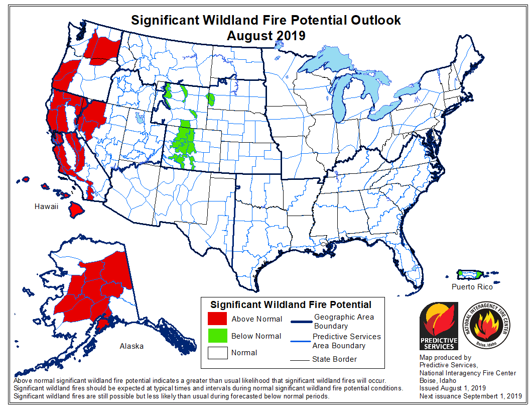
On August 1 the Predictive Services section at the National Interagency Fire Center issued their Wildland Fire Potential Outlook for August through November. The data represents the cumulative forecasts of the ten Geographic Area Predictive Services Units and the National Predictive Services Unit.
If NIFC’s analysis is correct, areas in Washington, Oregon, Nevada, and California will have elevated potential for wildfires in August and September. With the monsoons moving into the Southwest there are no areas east of those four states that NIFC identified as having high wildfire potential between August and November.
Below:
- An excerpt from the NIFC narrative report for the next several months;
- More of NIFC’s monthly graphical outlooks;
- NOAA’s three-month temperature and precipitation forecasts;
- Drought Monitor;
- Vegetation greenness map.From NIFC:
“Moderate to severe drought conditions exist across portions of northern Oregon, Washington, northern Idaho and western Montana. However, a recent extended period of cool and periodically moist conditions has lessened the drought stress in the vegetation. Moderate drought has emerged across the northeastern Interior of Alaska and on the Kenai Peninsula. Puerto Rico is also showing developing drought across the southern portion of the island.
“Looking forward, an active but compressed season is expected across the West as the southwestern monsoon becomes more active in August. While this will effectively end the season across the Southwest, lightning-induced fire activity is expected to increase elsewhere. Wind events, which have been largely absent thus far, will increase in frequency by mid to late month as dry frontal passages become a more common occurrence. The occurrence of both wind events and low humidities will influence an increase in fire behavior and growth. Activity in Alaska will continue to diminish as the frequency of frontal passages increases and as temperatures begin to cool. By mid-September the seasonal transition out of the core fire season will be underway as the seasonal transition begins to bring wetting systems to most regions.
“By October and November, however, California will reenter the fire season as Foehn Wind events begin to develop. Concerns this year are higher than average due to the presence of an abundant crop of fine fuels in the lower to middle elevations.”

July could bring elevated wildfire potential to parts of the west coast, Alaska, Arizona, and the Southeast
Moderate to severe drought conditions exist in western Oregon and Washington
Continue readingForecasters predict the potential for large wildfires will be higher than average on the west coast this summer
Areas to watch will be Northern California and the west sides of Oregon and Washington
Continue readingIncreased wildfire activity predicted for British Columbia and Yukon
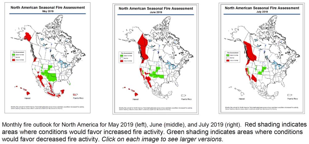
The Predictive Services section at the National Interagency Fire Center has predicted above normal wildfire activity this summer for southern Arizona, areas of California, and western Oregon and Washington.
An outlook for North America released on Friday also shows enhanced potential for British Columbia and the Yukon Territory in June and July.
Below is an excerpt from the North American Seasonal Fire Assessment and Outlook prepared by NIFC, Natural Resources Canada, and Servicio Meteorológico Nacional.
“For May, recent climate model runs suggest Canada will have lower fire severity than normal. While an early start to warm and dry conditions is leaving much of British Columbia prone to fire starts, rainfall is likely in the last half of the month, which will likely result in normal monthly fire severity for the province. The latest climate model runs hint at continued blocking ridges in the eastern Pacific during June, resulting in warm and dry conditions and resulting elevated fire severity indexes in British Columbia and Yukon. This pattern often features the eastern side of the ridge over the Prairies, so western Alberta also appears prone to elevated fire risk, while conditions east of Alberta are likely to have normal values. July’s forecast is similar to June’s forecast, with elevated fire severity indexes expected throughout British Columbia, western Alberta, and southern Yukon. A slight difference exists as the Yukon area depicted covers only the southern part of the territory in July, while in June it extended north near the Arctic coast.”

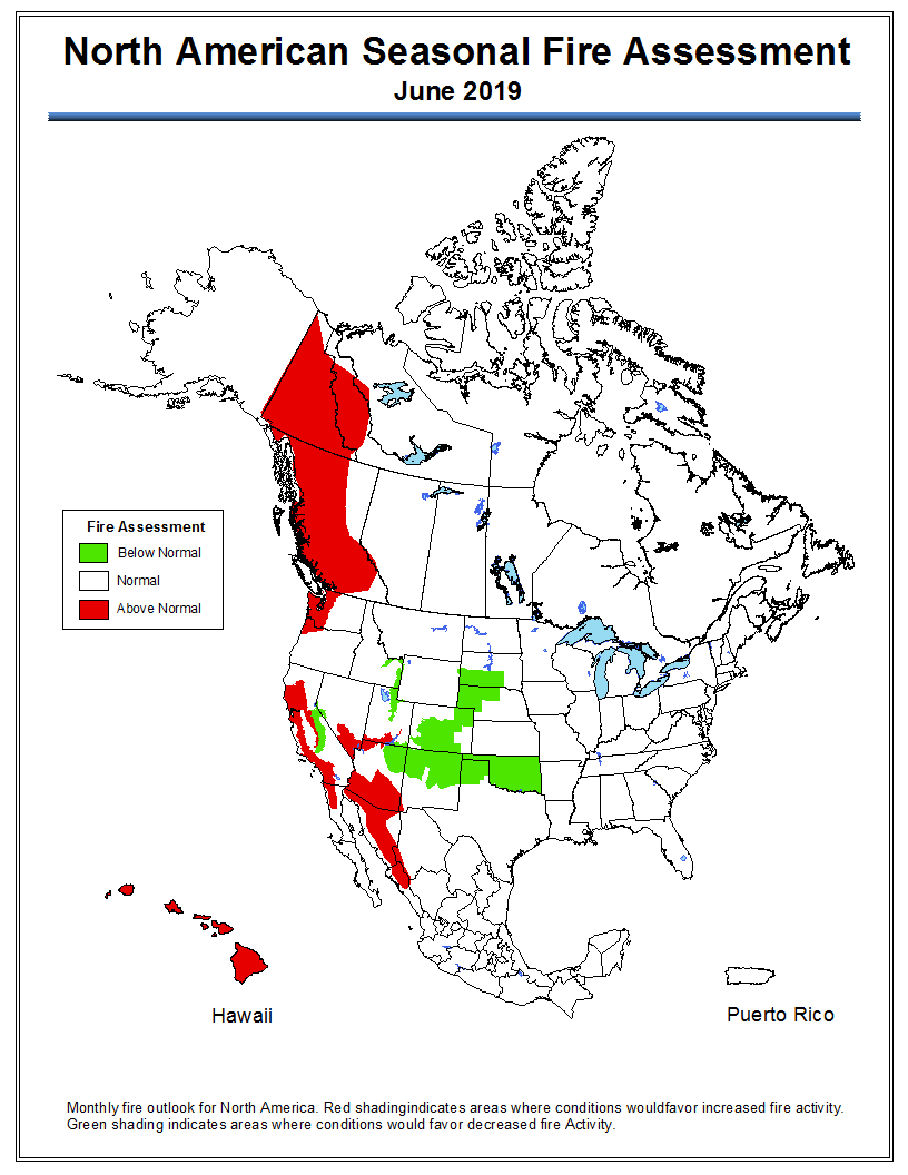
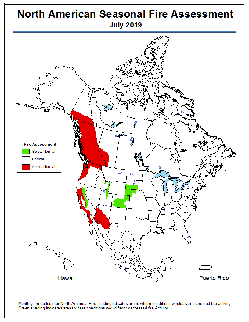
Wildfire potential, May through August
If NIFC’s analysis is correct, wildfire activity along the west coast will grow substantially into the summer
Continue reading