Western states drought continues, but wildfire threat eases

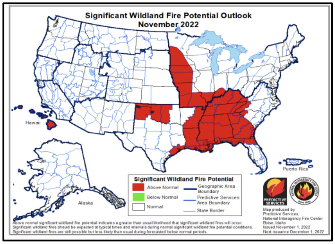
Wildfire outlook, November, 2022

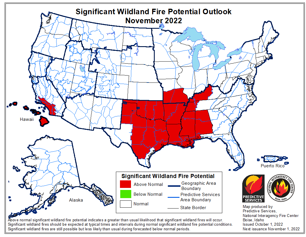
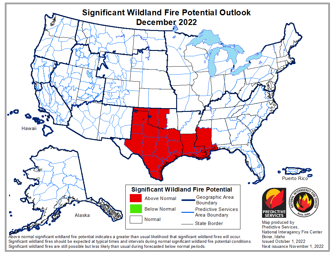
The wildland fire potential released today by the National Interagency Fire Center predicts no above average wildfire potential for the 11 western states for the next four months through February, 2023. However the Gulf and Southeast coasts will remain high during the entire period. It will also be high in the Southeast and the Mississippi Valley in November.

The fire potential text and maps from NIFC shown here represent the cumulative forecasts of the ten Geographic Area Predictive Services Units and the National Predictive Services Unit. Additional graphics are included from other sources.

Below:

  • Excerpts from the NIFC narrative report for the next four months;
  • Additional NIFC monthly graphical outlooks;
  • NOAA’s temperature and precipitation forecasts;
  • Drought Monitor;
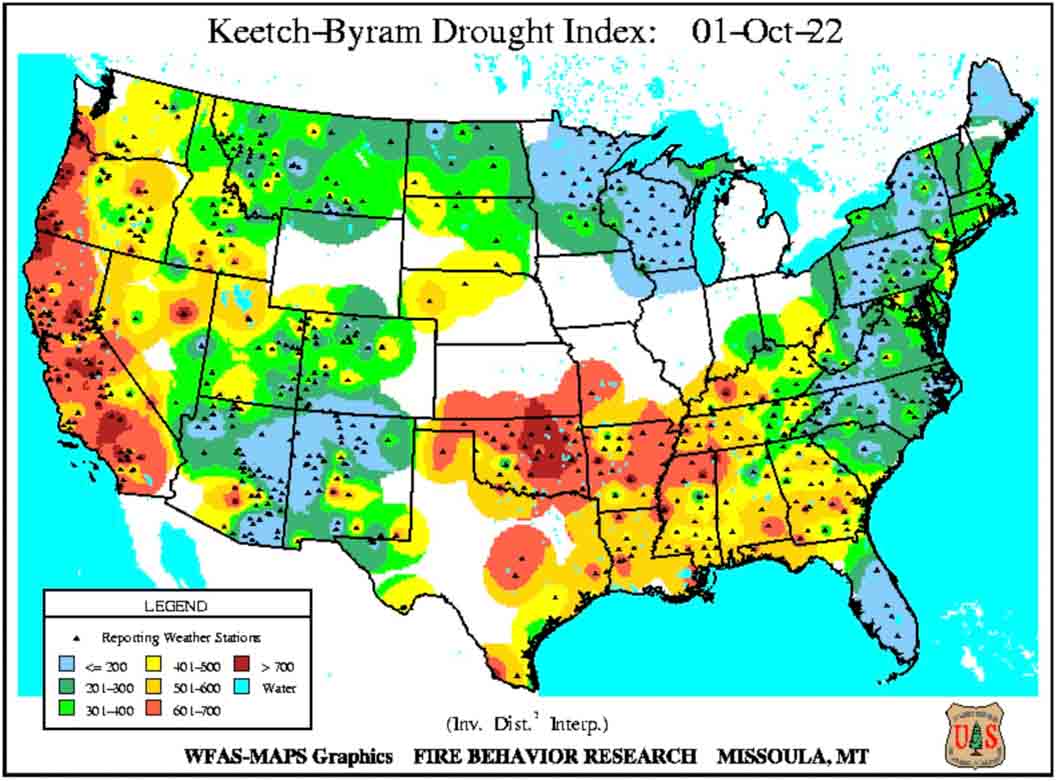
  • Keetch-Byram Drought Index;
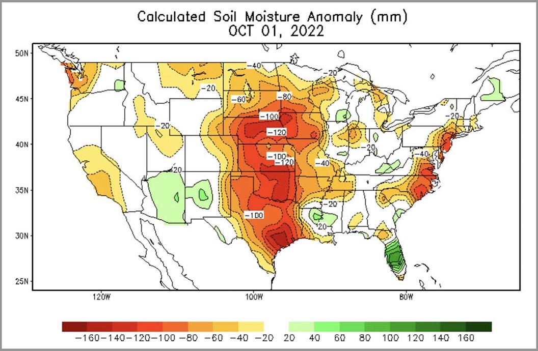
  • Soil moisture.

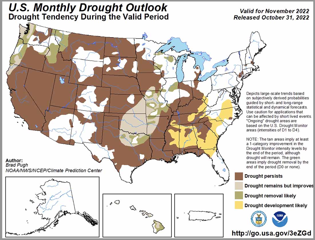
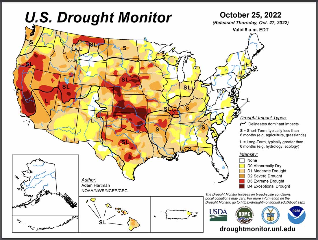
“Drought now covers nearly two-thirds of the contiguous US. Drought continues in much of the West, with expanding and intensifying drought in portions of the Northwest due to warmer and drier than normal conditions in October, including record setting temperatures.

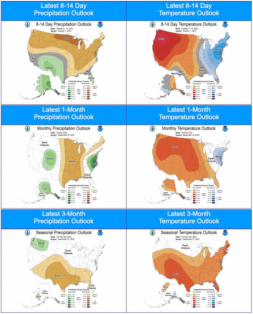
“Near to below normal temperatures and near to above normal precipitation are forecast from the Northwest through the northern Plains into the Great Lakes. Below normal precipitation is likely from southern California and the Southwest through the southern Plains to the Gulf and Southeast Coasts through winter. Above normal temperatures through the winter are likely across California, the southern Rockies into Texas, and along the Gulf and East Coasts.

“Above normal significant potential is forecast for the Hawai’ian Islands for November before returning to normal potential through winter. The Texas Panhandle, western Oklahoma, and western Mid-Mississippi Valley to the southern Appalachians and northern Gulf Coast are forecast to have above normal potential in November before mostly returning to normal for winter as well.

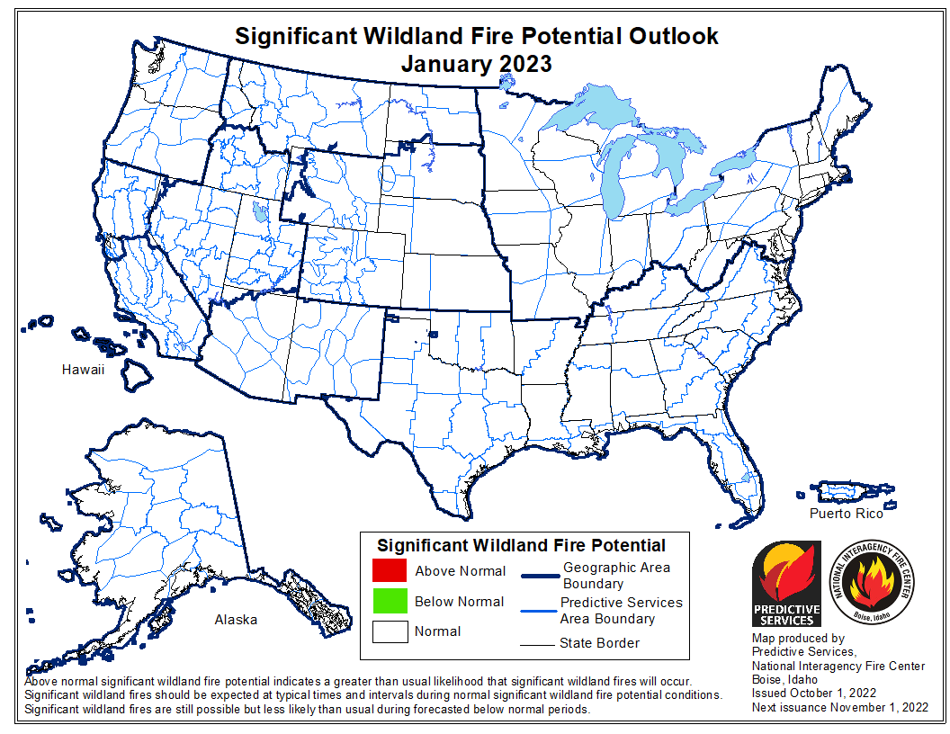
“In December, above normal significant fire potential will remain across the Lower Mississippi Valley and northern Gulf Coast, with above normal potential remaining near the northern Gulf Coast in January. Above normal significant fire potential is then forecast to expand into southeast New Mexico, south and west Texas, southwest Florida, and the Southeast coastal plain in February.”
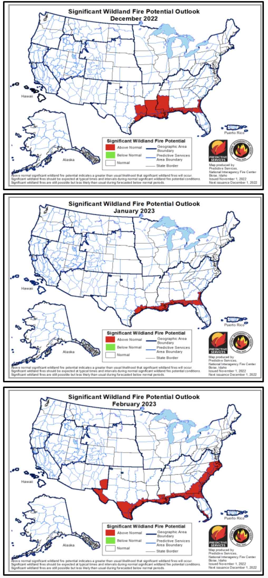

Wildfire Outlook, December through February
90- day Precip - Temperature forecast, issued Oct 20, 2022
90- day Precip – Temperature forecast, issued Oct 20, 2022
Drought monitor, Oct. 25, 2022
Drought Outlook, Oct. 31, 2022

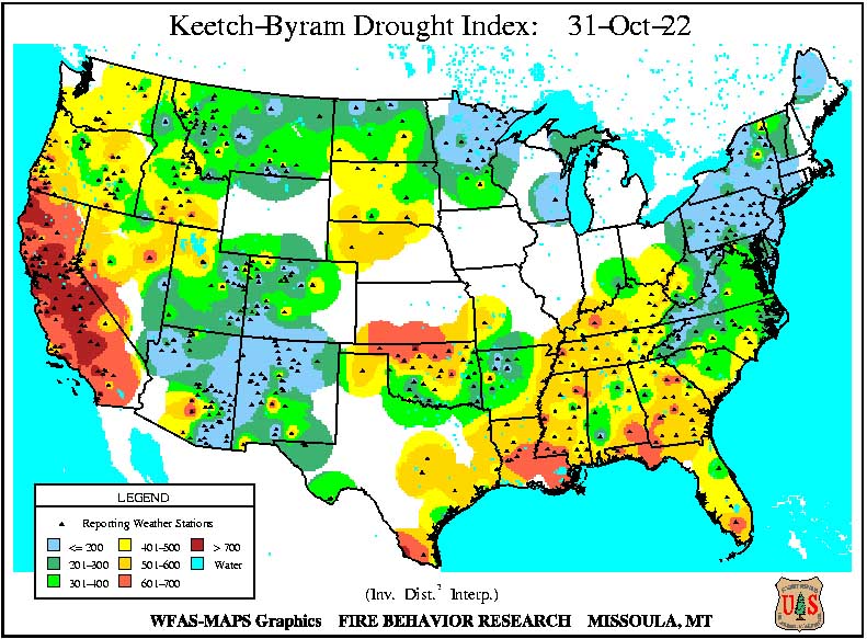
KBDI Oct. 31, 2022

Soil moisture, calculated anomaly, Oct. 31, 2022

Wildfire potential shifts to the south-central states

wildfire potential map

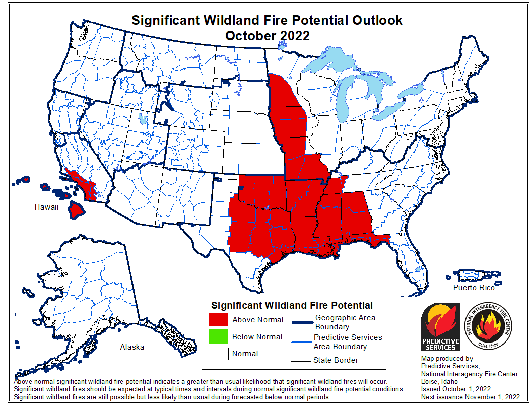
The forecast for wildland fire potential issued October 1 by the National Interagency Fire Center predicts that the wildfire potential shifts to the south-central United States over the next several months. Most of California has received more than the average amount of rain recently.

However some of the Southern California mountain areas have not received much wetting rain, therefore the prediction there is for above normal fire potential in October and November, possibly into December. The first widespread wetting rain this fall will likely follow two to three offshore wind events in Southern California.

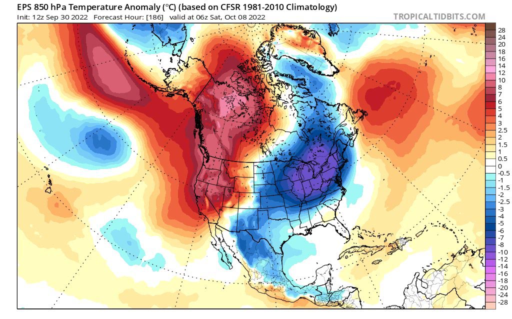
NIFC’s monthly forecasts are for the next four months, but in the shorter term, by the end of this week temperatures in the western US and Canada are expected to be 5C to 10C degrees above average for the date.

Temperatures week of Oct 2, 2022
Temperature anomaly October 9, 2022.

The fire potential text and maps from NIFC shown here represent the cumulative forecasts of the ten Geographic Area Predictive Services Units and the National Predictive Services Unit. Additional graphics are included from other sources.

Below:

  • Excerpts from the NIFC narrative report for the next four months;
  • Additional NIFC monthly graphical outlooks;
  • NOAA’s temperature and precipitation forecasts;
  • Drought Monitor;
  • Keetch-Byram Drought Index;
  • Soil moisture.

“Drought continues in much of the West, with expanding and intensifying drought in portions of the Northwest, Idaho, and Montana due to warmer and drier than normal conditions in September. Most of California received well above normal rainfall for the month and much of the Northeast did as well, helping to reduce drought in New England. Warmer and drier than normal conditions also occurred in much of the southern and northern Plains into parts of the Southeast, Texas, and Midwest.

“Near normal temperatures and near to above normal precipitation are likely for portions of the Pacific Northwest and northern Rockies into early winter. Near to below normal precipitation is forecast for the rest of the West through the southern and central Plains into the Gulf Coast and Southeast, barring any landfalling tropical cyclones on the Gulf and Atlantic Coasts. Near to above normal temperatures and near normal precipitation are forecast for the Midwest through the Mid-Atlantic and Northeast.

“Above normal significant potential is forecast for much of Oklahoma, Texas, the Lower Mississippi Valley, and central Gulf Coast into December. Above normal potential is likely for much of the Mississippi Valley in October and the western Ohio Valley through the Ozarks into November. Southern Area is forecast to return to near normal significant fire potential during January.

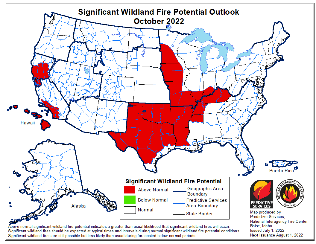
“The Transverse and Peninsular Ranges of southern California to the coast, areas prone to Santa Ana winds, will have above normal significant potential October through November, before returning to normal potential in December. The Hawai’ian Islands will continue to have above normal potential, especially lee sides, through November before returning to normal potential in December. All the US is forecast to have near normal significant fire potential during January.”

wildfire potential map wildfire potential map wildfire potential map

NOAA temperature and precipitation outlooks Drought Monitor, Sept. 27, 2022 KBDI October 1, 2022

Soil Moisture, October 1, 2022

Prediction issued for this summer’s wildfire potential

July wildfire outlook weather fuels

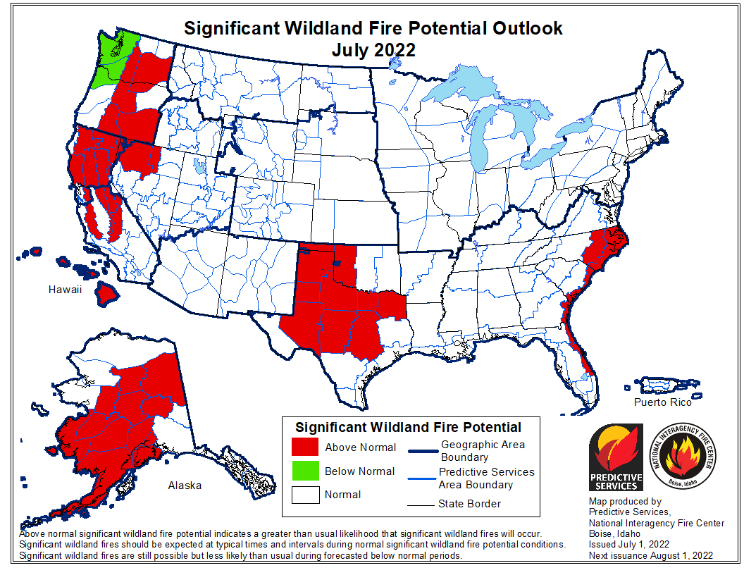
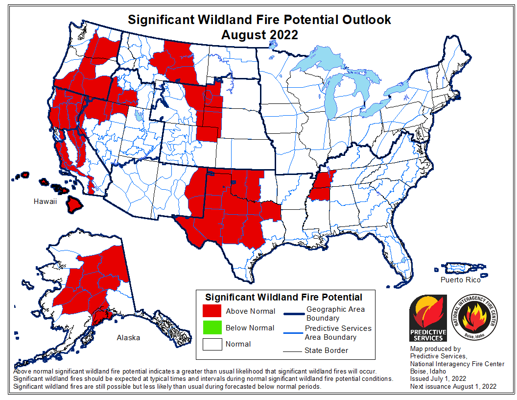
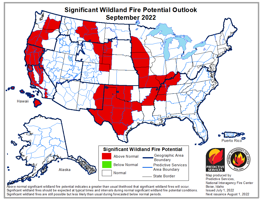
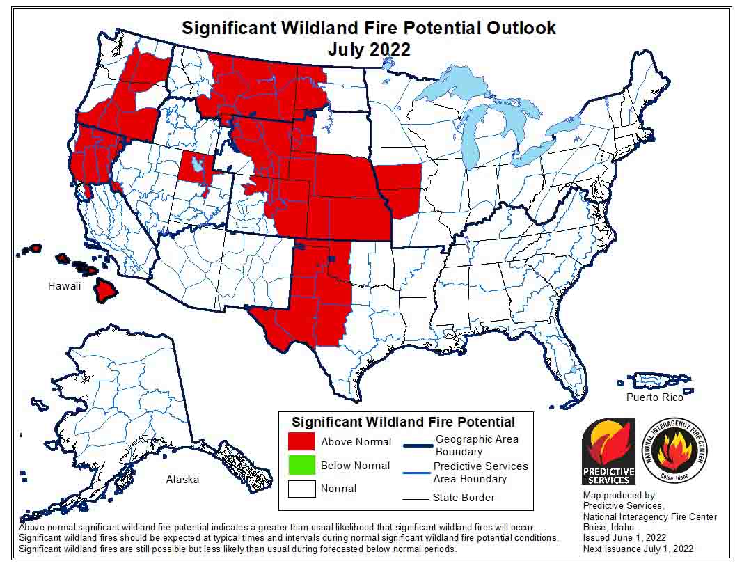
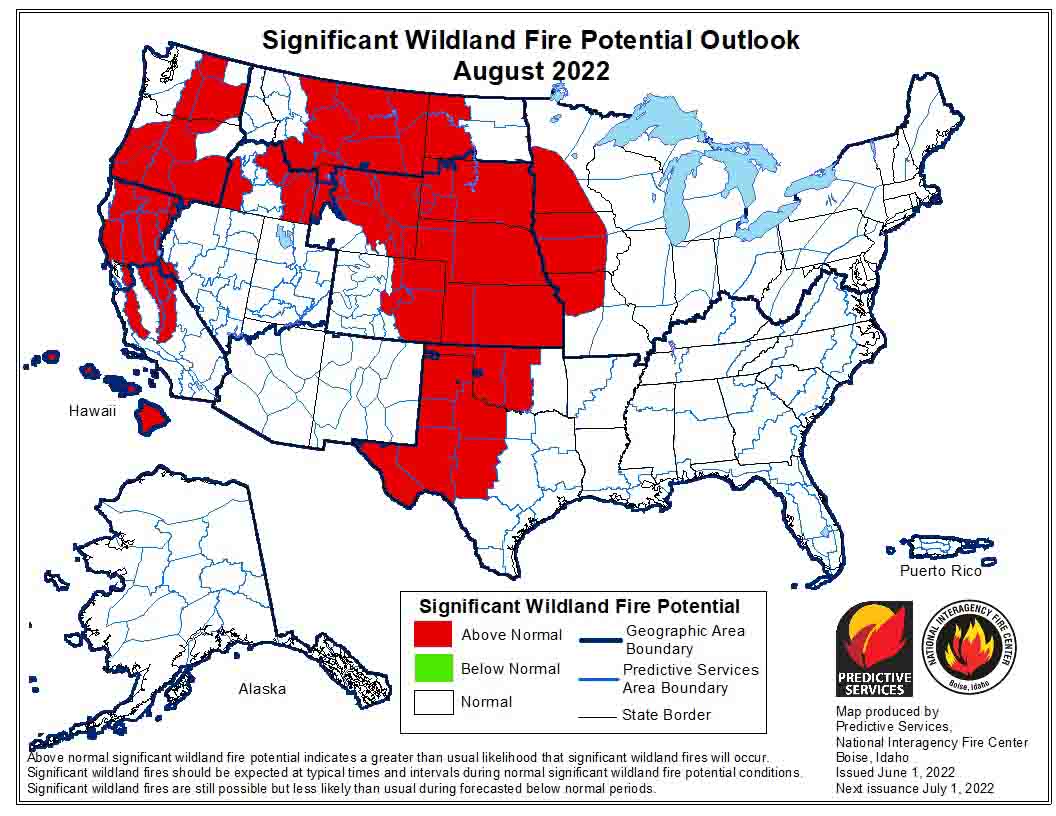
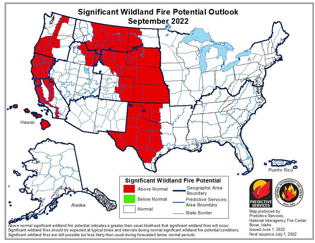
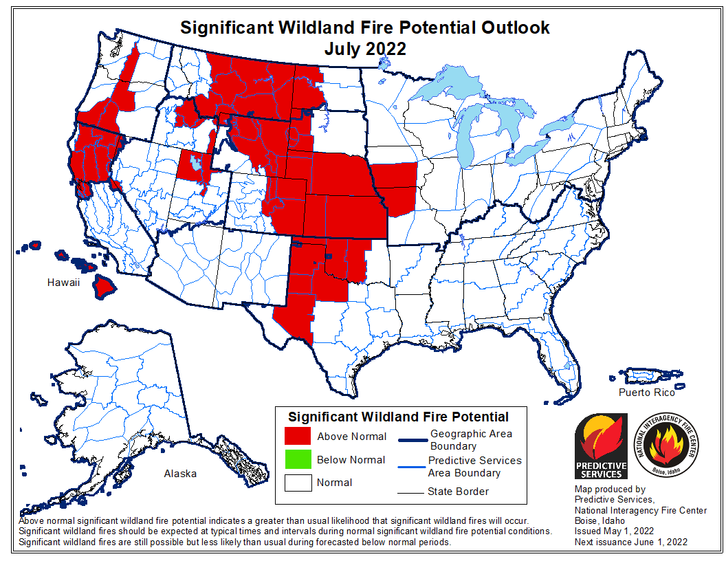
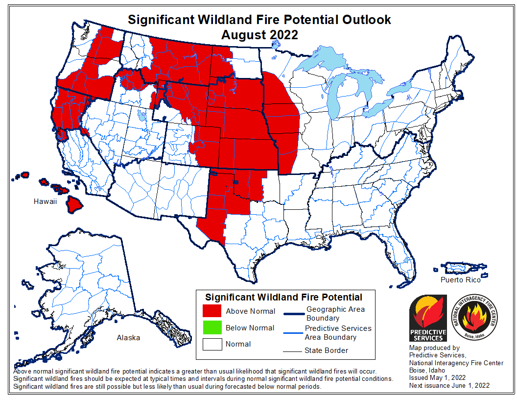
The forecast for wildland fire potential issued July 1 by the National Interagency Fire Center predicts that in July it will increase to higher than “normal” this summer in Alaska, Texas, Northern California, and the eastern portions of Washington and Oregon. In August added to the list will be parts of Montana, the Black Hills, and the Northern Plains. Hawaii will be above normal for the next four months.

The fire potential text and maps from NIFC shown here represent the cumulative forecasts of the ten Geographic Area Predictive Services Units and the National Predictive Services Unit. Additional graphics are included from other sources.

Below:

  • Excerpts from the NIFC narrative report for the next four months;
  • Additional NIFC monthly graphical outlooks;
  • NOAA’s three-month temperature and precipitation forecasts;
  • Drought Monitor;
  • Keetch-Byram Drought Index;
  • Soil moisture.

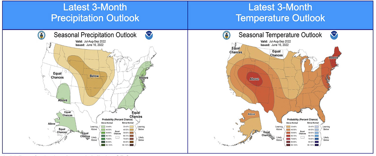
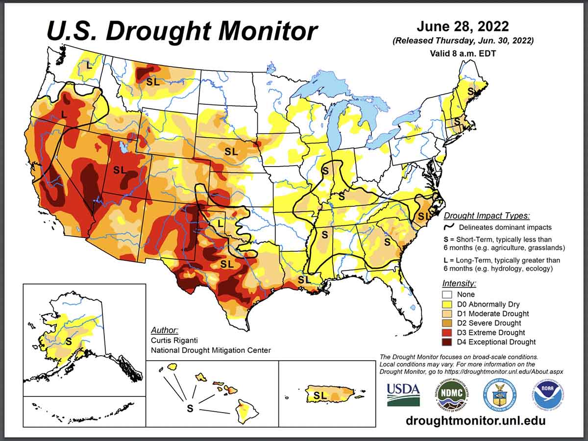
“Most of the West, Plains, and Texas remain in drought, with areas of extreme to exceptional drought across the southwestern US. Drought developed across southwest Alaska and expanded or increased in severity across the Southeast and Hawai’i. Temperatures were above normal across the southern tier of the US and the Plains, with near to below normal temperatures across the northwestern US and the Northeast.

“Climate outlooks indicate below normal precipitation is likely across much of the Plains through the central Rockies into the Inland Pacific Northwest, with above normal temperatures likely across most of the contiguous US (CONUS) through summer. A robust North American Monsoon is expected to continue through July into August across the Southwest and portions of the broader Four Corners region. Alaska is likely to remain warm, with near normal precipitation likely through summer.

“Above normal significant fire potential is forecast for the southern Plains through October, spreading across Texas, the Lower to Mid-Mississippi, Missouri, and Ohio Valleys by fall. Much of the central and northern High Plains, including the Black Hills, are likely to have above normal potential through summer. The Southwest, southern Great Basin, and Colorado Rockies have returned to near normal potential.

“Southwest, south-central, and Interior Alaska will have above normal significant fire potential through August, although portions of southwest Alaska will likely return to near normal potential during August. Much of the Sierra and Coast Ranges in California will have above normal significant potential by August, continuing through September. Offshore wind prone areas in California will likely retain above normal potential in October as well. Along and east of the Cascades into much of the western and northern Great Basin is expected to have above normal potential this summer due to above normal fine fuel loading and long-term drought, with southwest Oregon likely to have increasing potential by August. Leeward sides of the Hawai’ian Islands will have above normal potential through October due to ongoing drought and likely enhanced trade winds.”


August wildfire outlook weather fuels September wildfire outlook weather fuels October wildfire outlook weather fuels

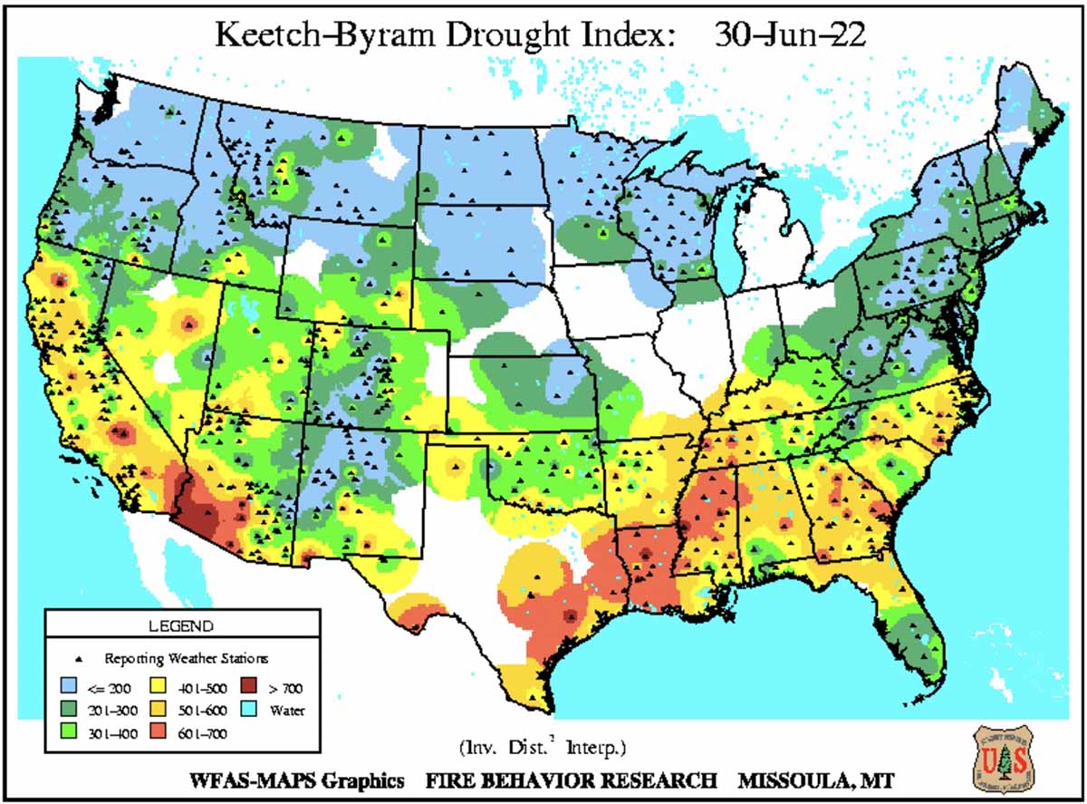
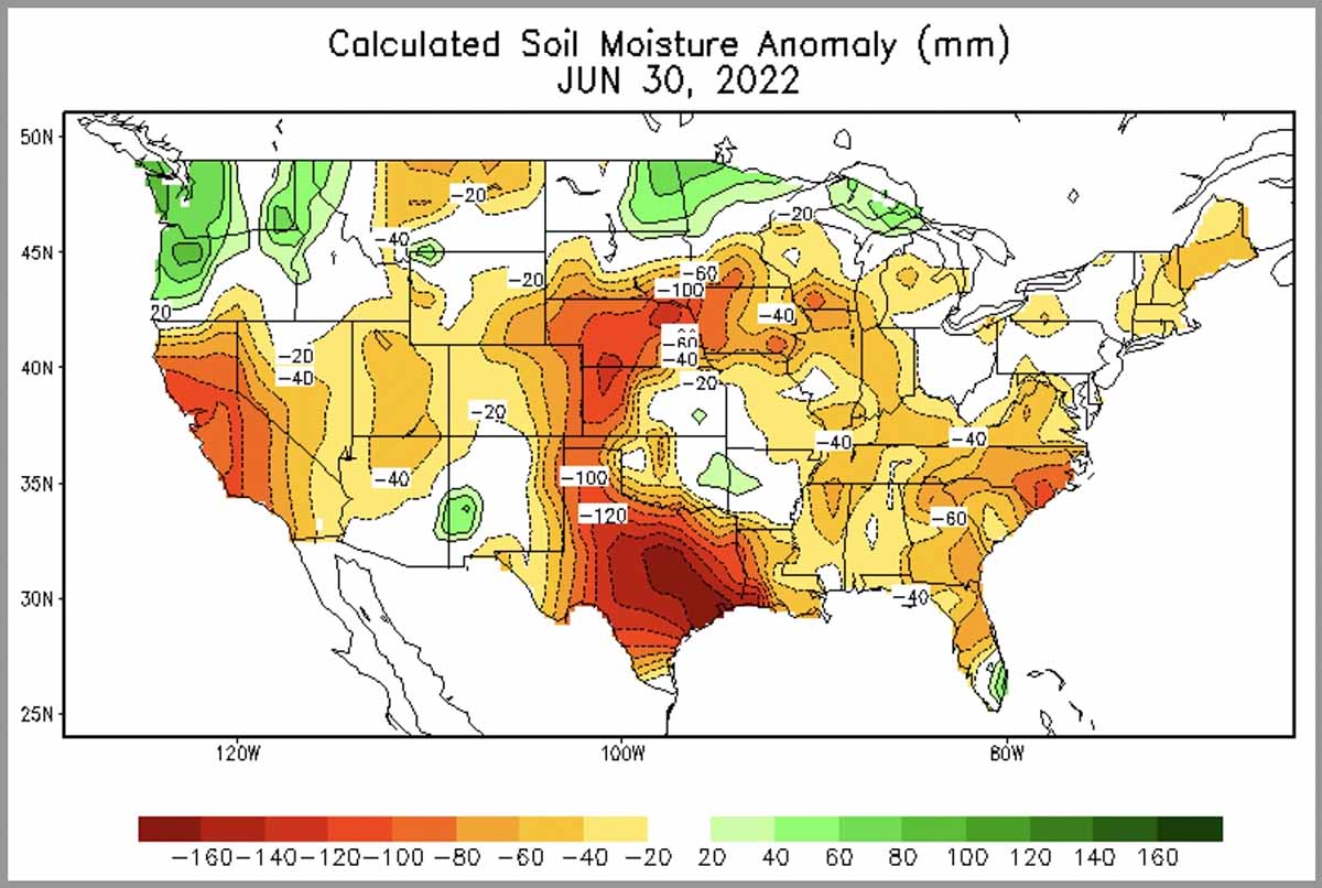
90-day temp & precip outlook Drought Monitor, June 28, 2022 KBDI June 30, 2022 Soil moisture, June 30, 2022

Increasing wildfire potential predicted for Northern California and Plains over next four months

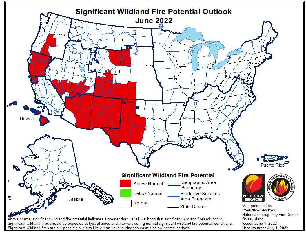
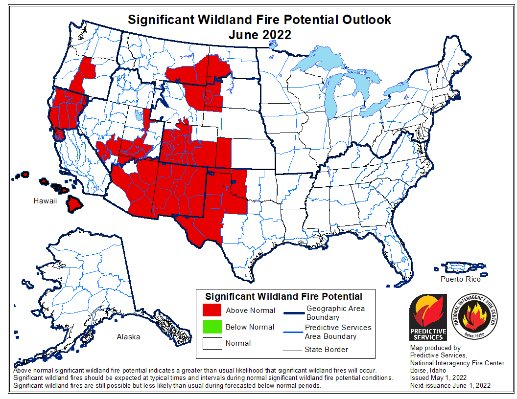
Fire potential outlook, June, 2022

The forecast for wildland fire potential issued June 1 by the National Interagency Fire Center predicts that the potential for wildfires will increase to higher than “normal” this summer in Northern California, the Plains states, and Northern Rockies.

The U.S. Drought Monitor reported May 24 that in California “snow cover is virtually non-existent below 8,000 feet; peak flow through area rivers and inflow into the reservoirs has already occurred or will occur soon, weeks ahead of normal; and applications for grants for well drilling, purchasing tanks, and bottled water recipients are increasing.” According to its most recent weekly report, 76 percent of land in the western United States is in severe drought or worse, up from 72 percent at the same time last year.

NOAA reported that the period from January to April was the driest on record in California. The Southwest region, which includes Arizona, New Mexico, Utah, and Colorado, experienced its driest period on record from May 2020 to April 2022.

The fire potential text and maps from NIFC shown here represent the cumulative forecasts of the ten Geographic Area Predictive Services Units and the National Predictive Services Unit. Additional graphics are included from other sources.

Below:

  • Excerpts from the NIFC narrative report for the next four months;
  • Additional NIFC monthly graphical outlooks;
  • NOAA’s three-month temperature and precipitation forecasts;
  • Drought Monitor;
  • Keetch-Byram Drought Index;
  • Soil moisture.

“Most of the West, Plains, and Texas remain in drought, with areas of drought in the Southeast and Hawai’i. Temperatures were above normal across the Southwest, Texas, and east of the Mississippi River, with below normal temperatures across much of the northern Intermountain West. Little snow remains across California and the southern Rockies, but snowpack in Washington and the northern Rockies is above normal for the end of May due to cool, moist storms thus far this spring.

“Climate outlooks indicate below normal precipitation is likely across much of the Plains through the central Rockies to the Northwest, with above normal temperatures likely across most of the contiguous US (CONUS) through summer. Critically windy and dry periods are likely to continue through mid-June for the Southwest and southern Great Basin. The North American Monsoon is likely to arrive on time and be robust this summer, but potential early moisture surges during June could result in periods of lightning across the Southwest, Colorado, and the southern Great Basin.

“Above normal significant fire potential is forecast for the southern High Plains through September, spreading across much of the Plains by August into September. Drier than normal conditions forecast in summer may lead to above normal potential developing across the western Mid to Upper Mississippi Valley in July and August.

“Most of the Southwest, southern Great Basin, and southern Colorado is forecast to have above normal significant fire potential in June, before returning to normal in July. Above normal significant fire potential is forecast across northern California and the lee sides of the Hawai’ian Islands through September, with above normal potential spreading into the southern Sierra and Coast Ranges of southern California in August and September. Above normal potential for central Oregon in June will expand across most of the Northwest by August, with above normal potential remaining in the Cascades and western Oregon in September. Central and eastern Montana east of the Continental Divide and much of Wyoming are forecast to have above normal potential July through September as well. Portions of southern and eastern Idaho are also forecast to increase to above normal potential in August and September.”


Fire potential outlook, July, 2022 Fire potential outlook, August, 2022 Fire potential outlook, September 2022

Continue reading “Increasing wildfire potential predicted for Northern California and Plains over next four months”

July and August wildfire danger predicted to be elevated in Great Plains, Rocky Mountains, and the Northwest

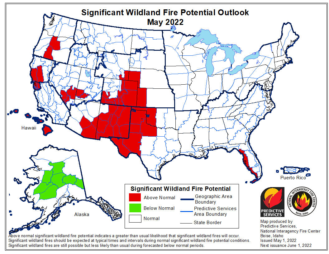
Wildfire potential May, 2022

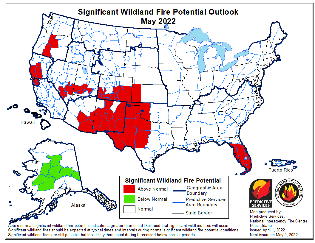
The forecast for wildland fire potential issued May 1 by the National Interagency Fire Center predicts that in July and August the wildland fire potential will be above normal in the Great Plains, Rocky Mountains, and the Northwest. Until then, in May and June it will be above average in the Southwest, Northern California, Central Oregon, and the Central and Southern Plains. Hawaii will be above normal for the entire May through August period, and Alaska will be in the normal range except in May when the central part of the state will be below normal. Most of the eastern half of the country is expected to be in the normal range through August.

The fire potential text and maps from NIFC shown here represents the cumulative forecasts of the ten Geographic Area Predictive Services Units and the National Predictive Services Unit. Additional graphics are included from other sources.

Below:

  • Excerpts from the NIFC narrative report for the next four months;
  • Additional NIFC monthly graphical outlooks;
  • NOAA’s three-month temperature and precipitation forecasts;
  • Drought Monitor;
  • Keetch-Byram Drought Index;
  • Soil moisture.

“Most of the West, Plains, and Texas remain in drought, with areas of drought also along the Gulf Coast and South Florida. Temperatures were above normal across the Southwest into Texas with below normal temperatures across much of the northern US. Below normal precipitation continued in the Southwest into the central and southern Plains. Snowpack continued to rapidly melt in the Southwest, with the below normal snowpack in the Northwest and Rockies melting off at a slow rate.

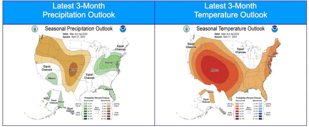
“Climate outlooks indicate below normal precipitation is likely across much of the Plains west through the central Rockies to the Northwest, with above normal temperatures likely across much of the contiguous US (CONUS) through spring into summer. Critically windy and dry periods are likely to continue through June for the Southwest and central and southern High Plains with an active severe weather pattern to the east over the eastern Plains and Ohio Valley. The North American Monsoon is likely to arrive on time and be robust this summer, but potential early moisture surges during June could result in periods of lightning across the Southwest, Colorado, and the southern Great Basin.

“Above normal significant fire potential is forecast across the western Florida peninsula in May. The southern High Plains will retain above normal significant fire potential through August, with much of the Plains forecast to have above normal potential by July and spread into the western Mid-Mississippi Valley in August after green-up and subsequent curing occurs due to anticipated warmer and drier than normal conditions.

“Most of the Southwest is forecast to have above normal significant fire potential in May and June, with potential increasing across southern and western Colorado and southern portions of the Great Basin before returning to normal in July. Above normal potential will likely expand from central Oregon to southwest Oregon and central Washington by July and much of the Northwest in August. Above normal significant fire potential is also forecast to increase across northern California from May into July, with rising potential likely along portions of the Sierra Front. Alaska is forecast to have below normal potential across the Interior in May, returning to normal in June. Leeward locations of Hawaii are forecast to have above normal potential during June and July.”


Wildfire potential June, 2022 Wildfire potential July, 2022 Wildfire potential August, 2022.

Three-month precipitation and temperature outlook, May through July, 2022
Three-month precipitation and temperature outlook, May through July, 2022. Created April 21, 2022.

Continue reading “July and August wildfire danger predicted to be elevated in Great Plains, Rocky Mountains, and the Northwest”

Higher than average wildfire activity expected in Southern Plains and Southwest, April through June

Prediction released for April through July

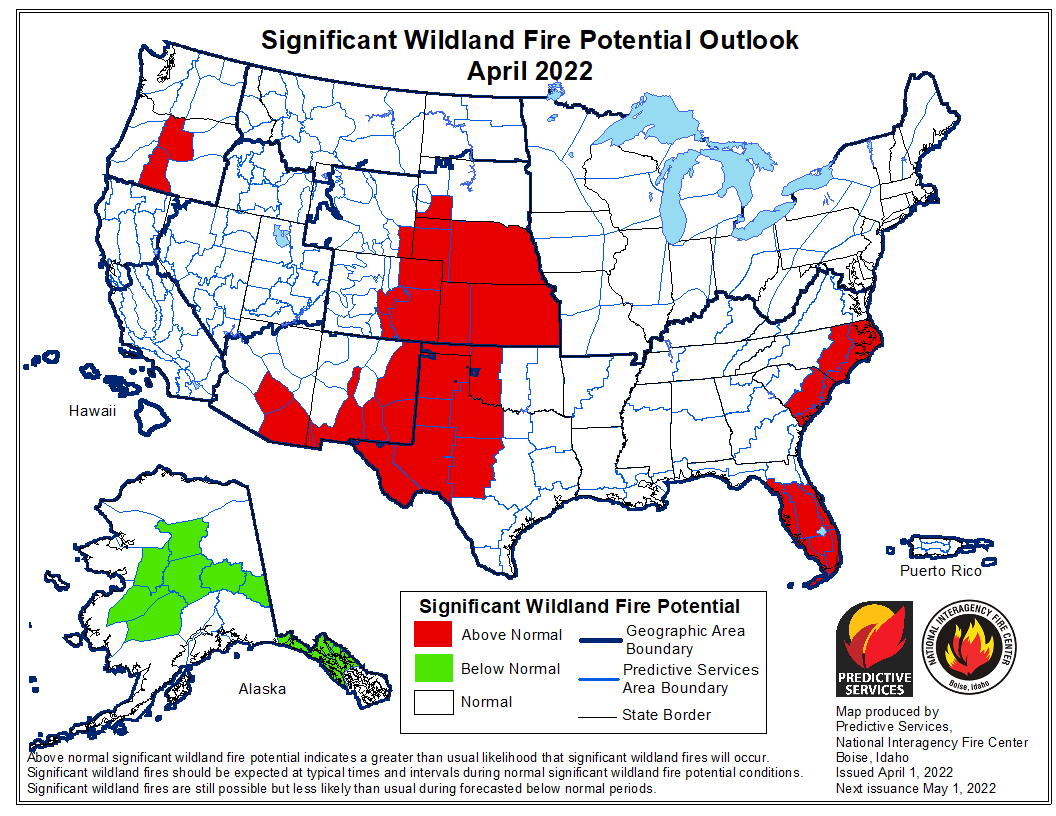
wildfire potential April 2022

The forecast for wildland fire potential issued April 1 by the National Interagency Fire Center predicts that over the next three months the potential will be higher than average in the Southern Plains and the southwestern states.

While large sections of Oregon, Washington, and Northern California are expected to be busier for firefighters than average May through July, average conditions are in the forecast for Central and Southern California during the next four months.

The data from NIFC shown here represents the cumulative forecasts of the ten Geographic Area Predictive Services Units and the National Predictive Services Unit.

Below:

  • Excerpts from the NIFC narrative report for the next four months;
  • Additional NIFC monthly graphical outlooks;
  • NOAA’s three-month temperature and precipitation forecasts;
  • Drought Monitor;
  • Keetch-Byram Drought Index;
  • Soil moisture.

“Most of the West, Plains, and Texas remain in drought, with areas of drought also along the Gulf Coast, in South Florida, and in the eastern Carolinas. Most basins in the West are reporting below average snow water equivalent (SWE), but Alaska has above normal snowpack and snow cover.

Climate outlooks indicate likely below normal precipitation from Texas through the southern Rockies and Great Basin, with above normal temperatures likely across much of the contiguous US (CONUS) through spring into summer. Indications for an active severe weather pattern this spring remain from eastern portions of the Plains into the Southeast and Ohio Valley, and critically dry and windy periods will accompany the severe weather for much of the Plains, especially the southern and central High Plains. The North American Monsoon is likely to arrive on time, but potential early moisture surges during June could result in lightning across the Southwest, Colorado, and the southern Great Basin.

“Above normal significant fire potential is forecast across the eastern Carolinas for April and in South Florida through May. The southern High Plains will retain above normal significant fire potential into July, with much of the Plains forecast to have above normal potential by July after green-up and subsequent curing occurs due to anticipated warmer and drier than normal conditions.

“Most of the Southwest is forecast to have above normal significant fire potential in May and June, with potential increasing across southern and western Colorado and southern portions of the Great Basin. Above normal potential will likely expand from central Oregon to southwest Oregon and central Washington by July. Above normal significant fire potential is also forecast to increase across northern California from May into July, with rising potential likely along portions of the Sierra Front. Alaska is forecast to have below normal potential in its panhandle through April, with below normal potential expected across large portions of the Interior through May. Leeward locations of Hawaii are forecast to have above normal potential during June and July.”


wildfire potential May 2022

Continue reading “Higher than average wildfire activity expected in Southern Plains and Southwest, April through June”