(UPDATE at 8:12 a.m. PT, June 24, 2015)

Below is an update on the fire, from the incident management team Tuesday night:
“Firefighters made excellent progress today by strengthening fire lines and establishing five percent containment on the 16,553 acre fire. The Washington Fire, 8 miles south of Markleeville, CA, experienced lighter winds and burning conditions more conducive to aggressive ground and air suppression actions.
“Several campgrounds along Highway 4 to the north end of Markleeville remain evacuated. For the safety of the public and active fire suppression activities, Highways 4 and 89 in the Monitor Pass area remain closed, as do the Turtle Rock and Indian Creek campgrounds. Markleeville residents remain under an evacuation advisory issued by Alpine County Sherriff’s office. No mandatory evacuations are in effect at this time.
“Twelve helicopters and 8 air tankers support the suppression effort on the fires, dropping retardant, ferrying equipment and supplies, transporting firefighters, and providing essential surveillance of areas far inside the perimeter not safely accessible by foot. Other key resources include 19 engines, 10 water tenders, and 19 crews. There are approximately 681 personnel assigned to the fire.
“Firefighters made significant progress around the entire fire perimeter, with their priority being the line along the north of State Highway 89. The primary tactical priority is to prevent the fire from reaching Markleeville. The next priorities are to buttress the lines along Wolf Creek and the Leviathan Mine reclamation site.”
****
(UPDATE at 3:19 p.m. PT, June 23, 2015)

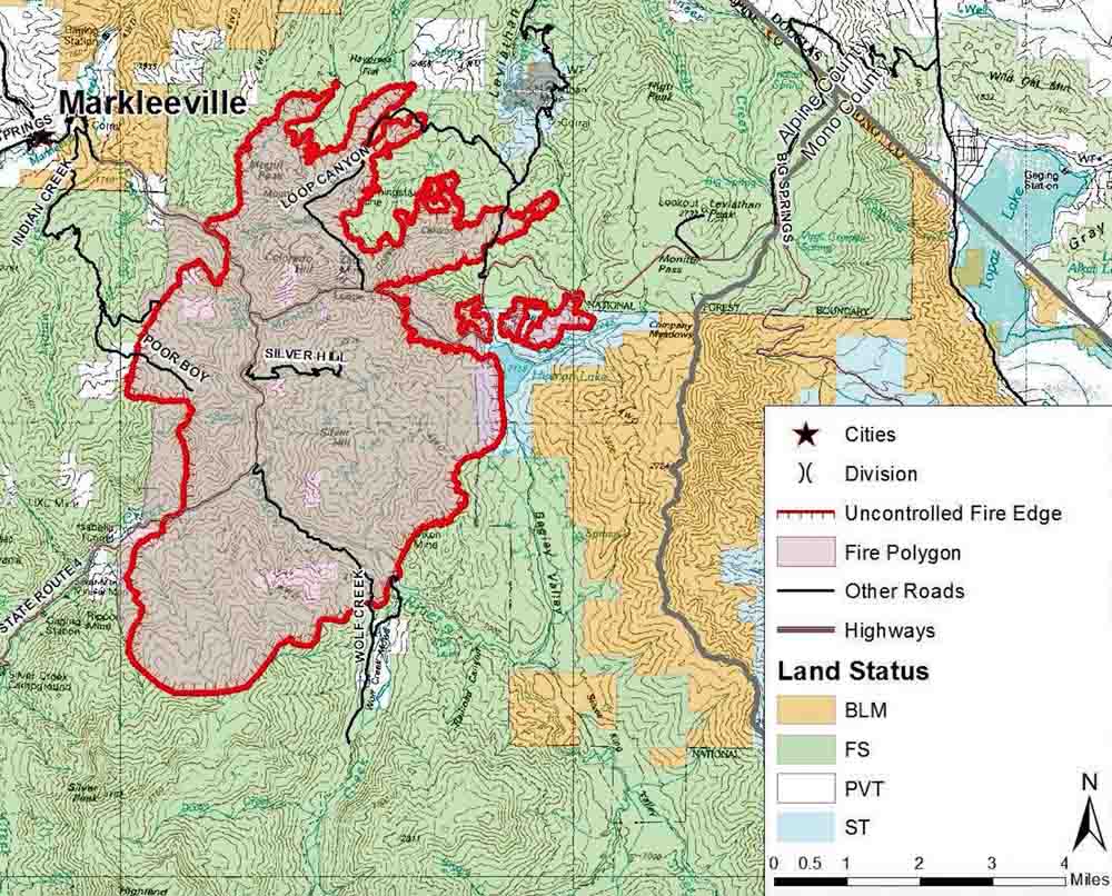
The incident management team for the Washington Fire near Markleeville, CA posted this map today, Tuesday. It is labeled June 22 at 1200, but it does not indicate when the perimeter was mapped. This is a portion of the map; you can see the entire map here. The fire is still listed at 16,544 acres.
****
(UPDATE at 10:33 a.m. PT, June 23, 2015)

The Washington Fire south and east of Markleeville, California was relatively quiet overnight due to very little wind and an inversion that settled into the area.
On Monday the area of the fire that was initially heading to the northwest toward the town of Markleeville moved more to the east than the north. The tactical priority is still to keep the fire from spreading further northwest towards the town.
Continue reading “Washington Fire, near Markleeville, California”
