(UPDATE at 8:12 a.m. PT, June 24, 2015)
Below is an update on the fire, from the incident management team Tuesday night:
“Firefighters made excellent progress today by strengthening fire lines and establishing five percent containment on the 16,553 acre fire. The Washington Fire, 8 miles south of Markleeville, CA, experienced lighter winds and burning conditions more conducive to aggressive ground and air suppression actions.
“Several campgrounds along Highway 4 to the north end of Markleeville remain evacuated. For the safety of the public and active fire suppression activities, Highways 4 and 89 in the Monitor Pass area remain closed, as do the Turtle Rock and Indian Creek campgrounds. Markleeville residents remain under an evacuation advisory issued by Alpine County Sherriff’s office. No mandatory evacuations are in effect at this time.
“Twelve helicopters and 8 air tankers support the suppression effort on the fires, dropping retardant, ferrying equipment and supplies, transporting firefighters, and providing essential surveillance of areas far inside the perimeter not safely accessible by foot. Other key resources include 19 engines, 10 water tenders, and 19 crews. There are approximately 681 personnel assigned to the fire.
“Firefighters made significant progress around the entire fire perimeter, with their priority being the line along the north of State Highway 89. The primary tactical priority is to prevent the fire from reaching Markleeville. The next priorities are to buttress the lines along Wolf Creek and the Leviathan Mine reclamation site.”
****
(UPDATE at 3:19 p.m. PT, June 23, 2015)
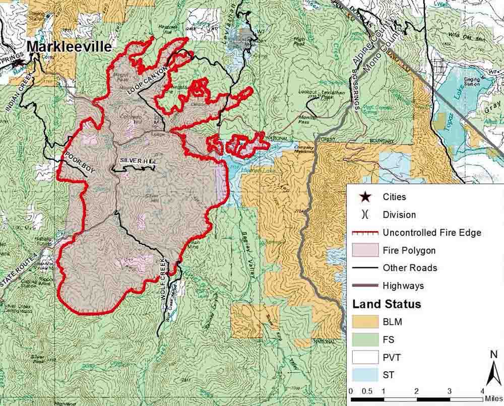
The incident management team for the Washington Fire near Markleeville, CA posted this map today, Tuesday. It is labeled June 22 at 1200, but it does not indicate when the perimeter was mapped. This is a portion of the map; you can see the entire map here. The fire is still listed at 16,544 acres.
****
(UPDATE at 10:33 a.m. PT, June 23, 2015)
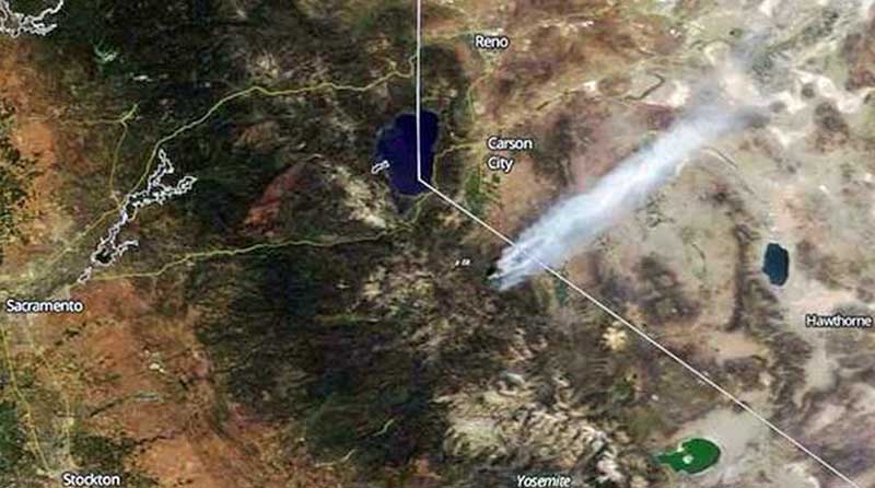
The Washington Fire south and east of Markleeville, California was relatively quiet overnight due to very little wind and an inversion that settled into the area.
On Monday the area of the fire that was initially heading to the northwest toward the town of Markleeville moved more to the east than the north. The tactical priority is still to keep the fire from spreading further northwest towards the town.
The fire is being managed by Chris Wilcox’s Type 2 Great Basin Incident Management Team. The estimated size of the fire is 16,544 acres. Assigned are 11 helicopters, 8 air tankers, 17 engines, 3 water tenders, 15 crews, and 22 overhead, for a total of approximately 500 personnel. Two of the air tankers are DC-10s that carry 11,600 gallons of fire retardant, three to six times more than the 2,000 to 4,000 gallons smaller air tankers carry
Firefighters plan to continue direct line construction on Tuesday north of Highway 89, using air and ground resources.
Several campgrounds along Highway 4 north of Markleeville have been evacuated. Highways 4 and 89 in the Monitor Pass area are closed. As a precaution, Markleeville residences have been advised to prepare for an evacuation if the need arises, however, no mandatory evacuations are in effect for Markleeville at this time.
The weather forecast for the fire area calls for 82 degrees, 11 percent relative humidity, and winds of 2 to 10 mph switching from the southwest to north.
****
(UPDATE at 8:15 p.m. PDT, June 22, 2015)
The Sierra Front Interagency Dispatch Center reports that the Washington Fire south and east of Markleeville, California has burned 14,942 acres.
View of the #WashingtonFire near #Markleeville from flight UA4976 yesterday pic.twitter.com/mzC04vSRQY
— Jonathan Wibberley (@nanjido) June 22, 2015
****
(UPDATE at 1:44 p.m. PT, June 22, 2015)
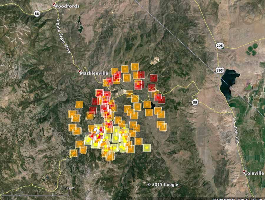
The updated map of the Washington Fire from 1:15 p.m. PT, June 22 satellite data shows minimal movement since the last data at 3:55 a.m. on June 22. However, that time period is the one in which you would expect the least movement of the fire. The fire behavior could change Monday afternoon. In the new revised map, additional heat was detected on the northeast side of the fire. Sierra Front Interagency Dispatch Center reported at 12:30 local time that the fire had burned approximately 9,500 acres; they will have a more accurate assessment following an infrared mapping flight. Firefighting resources are focusing their efforts on the northwest flank of the fire in an effort to protect the town of Markleeville, CA.
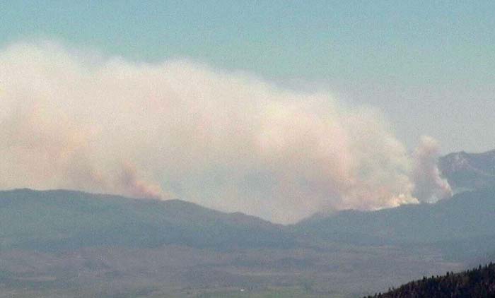
On Sunday June 21, the Type 3 Sierra Front Incident Management Team was assigned to the Washington fire. A transition to a Type 2 incident management team (Great Basin Team 4-Wilcox) occurred at 6:00 a.m. Monday June 22. Approximately 300 personnel are assigned to the incident with more to arrive on Monday.
****
(UPDATE at 8:20 a.m. PT, June 22, 2015)
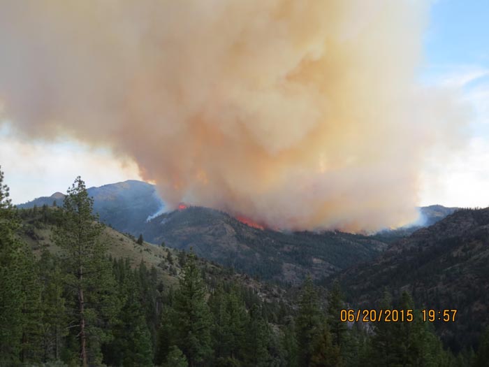
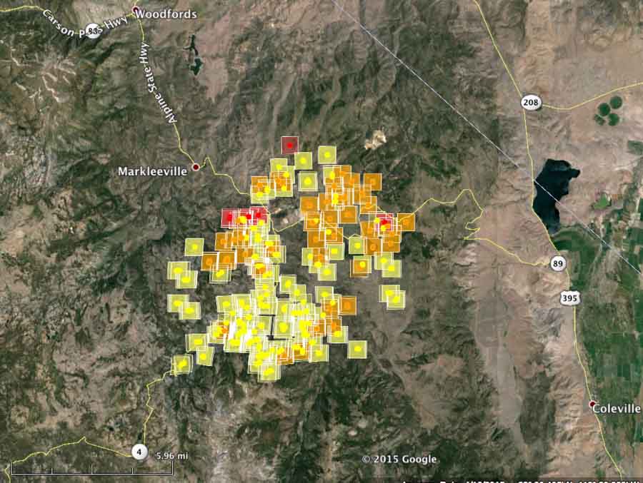
The map of heat detected by a satellite at 3:55 a.m. PT on Monday indicates that the Washington Fire has crossed Highway 89 and is approximately 3 miles east of Markleeville. The spread between Sunday afternoon and very early Monday morning was primarily to the north and northeast. The fire is about 5 miles from the California/Nevada border and 6 miles west of Highway 395.
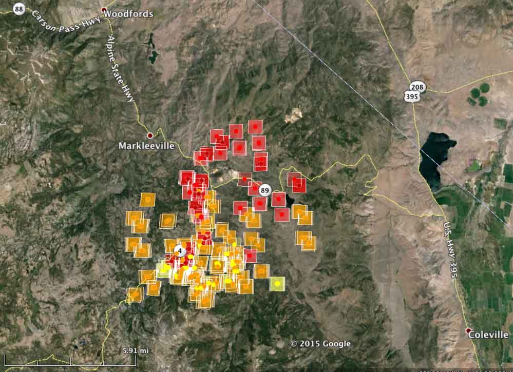
Judging from the satellite map, the fire appears to be approximately 12,000 acres. Sunday afternoon the Sierra Front Interagency Dispatch Center reported that it was 6,500 acres. The weather forecast for the fire area for Monday is not good news for firefighters. They can expect temperatures in the mid-80s, winds out of the southwest at 13 to 15 mph gusting to 23 late in the afternoon, and a minimum humidity of 11 percent. Tuesday will be about the same, except the wind will be out of the northwest at 6 to 10 mph.
****
(Originally published at 6 p.m. PT, June 21, 2015)
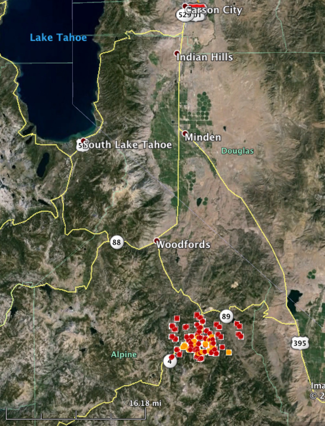
A rapidly spreading fire is threatening the town of Markleeville in the Sierra Mountains of California. The Washington Fire started Friday night and did not do much until 24 hours later when it grew from about 75 acres to 350 in a few hours. Strong winds overnight kept spreading it and by Sunday afternoon firefighters estimated it had burned 6,500 acres. Judging by the satellite map above, which shows heat detected by a satellite at 3:50 p.m. PT on Sunday, it could be thousands of acres larger than that. At 4:30 p.m. PT on Sunday, Elizabeth Kenna, a Public Information Officer, said a spot fire on the west side of Highway 4 required an evacuation from the river up to the north end of Markleeville. The fire has moved to the north side of Highway 89 and is now in the Bagley Valley. The Washington fire area is experiencing extreme winds. Highway 4 is closed, and all visitors and campers from Wolfcreek to the top of Ebbitts Pass have been evacuated. At 3:50 p.m. on Sunday the fire was just south of Loops, 3 miles south of Markleeville, 6 miles southwest of the California/Nevada border, and 24 miles southeast of the south shore of Lake Tahoe.
Smoke from #WashingtonFire in Alpine County as detected by @NOAASatellites pic.twitter.com/c9p8JsZvdd — D. Wilson (@ButteWxSpotter) June 21, 2015

Just got back from Markleeville. We spent the weekend fishing the Carson River among the ashes and burnt ground. It was an amazing job that was done saving the town from the fire. So sad to see so much wildlife and beauty destroyed. Now, the clean up and restoration has to happen. It was great to see wild flowers, butterflies, and deer coming back in to the burned areas though. Given time, it will all be okay.
Again, it was an incredible job done. Thank you firefighters.
Anyone know why Inciweb lists this fire being in Nevada when it is entirely within California?
Fire dispatching in that area is the responsibility of the Great Basin Geographic Area. The boundary between the Great Basin and the California Areas does not always follow the state lines. But, in my opinion, it SHOULD be listed as a California fire on Inciweb, which sorts fires by states, not Geographic Areas.
Thank you. You and your crew do excellent work.
Born and raised in Gardnerville. Grandfather sent cattle to Wolf Creek in the summer. Know Markleeville sit in a hole escape is not easy. Sincerely hope it rains or better yet snow Markleeville and especially Wolf Creek is very special and pristine. Bull Lake and Asa Lake are critical, Noble Lake is a grunt to get to but well worth it. Bull Lake loves fly fishermen, been years since was there, if you did not know how to get there……………you would not. Ken
Does anyone know the status of the Chalmers Mansion? From the looks of it, the southwestern boarder of the fire is almost exactly on top of it. (1 mi east of the Isabella Tunnel shown on the map)
Bill, your updates on this fire are better than any source I have found.
My wife and I rode our motorcycle Saturday from Carson City, through Markleeville then over Ebbett’s Pass to Bear Valley and back. Strangely, we saw no sign of fire but maybe we were too busy dodging bicyclists and oncoming cars that were also dodging.
While every wildfire is a tragedy, this one particularly saddens us since the map of burned over areas along Rt. 4 and 89 over Monitor Pass are wonderful for riding and hiking, and an area we always looked forward to visiting. Sounds selfish I guess…
Best wishes to all the firefighters out on the line. Be safe and thanks for everything you are doing to save Markleeville and surroundings.
Thanks Steve. Glad you find it useful.
Lived in Markleeville for several years and it holds a very special place in my heart. My prayers for the people and the town, hoping the fire bypasses.
MARSHA AN I RAN A COFFEE SHOP AND HAD SAT.NIGHT SALMON B.B.Q.’S ALSO HAD A POPULAR CABIN RENTAL “BED BIKE AND BAGEL
FOR “THE DEATH RIDE ” HELD EVERY YEAR BASED IN MARKLEEVILLE ……..SAD NEWS INDEED !!! THERE IS ONLY ONE MARKLEEVILLE , I HOPE EVERY EFFORT POSSIBLE IS DIRECTED TO SAVING THE TOWN .
Ed, I hope you have success in fixing that stuck CAPS LOCK KEY, because it looks like YOU’RE YELLING!
Hey Ed! Wahhoo! How are you? This is Mary Kay who used to be your website provider for your Coffee Shop & B&B in Markleeville! It is great to see your post! After you and Marsha sold, Tom and I posted your very nice note on the office wall, and we always hoped everything turned out great for you and Marsha! Best wishes and everything good to you! — Mary Kay aufrance dot com
How did the fire start?
Lightning.
Appreciate the comprehensive updates.
You’re very welcome.
As mentioned numerous times on this site if an agency doesn’t attack the fire within twenty minutes using fixed wing aircraft and retardant the probability of containment in many cases will not be accomplished. A SEAT (600 gallons) flying 60 air miles to the fire is of little I.A. use. There use to be a heavy tanker base at Minden, gone? How many VLAT where available?
Too windy for aircraft yesterday, per Alpine County Fire. (We were spending the weekend in Markleeville with friends, when the fire department came around to hint it would be a good idea to go.) We had awakened Sunday to the roaring of wind in the treetops.
Living close to this area and will soon be impacted by smoke I wonder how long it will be before there will an aggressive attempt to contain this fire. Two SEATS and a RJ flying from Castle (one hour turn arounds) doesn’t seem to be too aggressive. Who would have thought that the West could have a serious fire season? Business as usual.