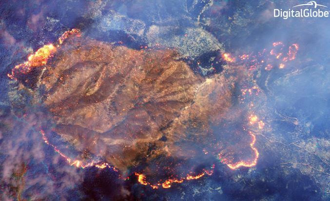
On August 13, 2014 a privately owned company launched another of their satellites to photograph the Earth’s surface. Digital Globe’s WorldView-3 satellite has advanced technology, a shortwave infrared (SWIR) sensor, that can see through the dense smoke of an active wildfire. The image above was collected from 383 miles above the ground during the last week of August while the Happy Camp Complex of fires in northwest California was spreading along most of its perimeter. At the Digital Globe website, there is a photo with a slider that compares the smoke-obscured visible spectrum imagery with the SWIR photo above. The difference is striking.
After they receive clearance from the U.S. Government, they will make available satellite imagery with a one-foot (30 cm) resolution, which is unprecedented outside of the government.
On their website, Digital Globe wrote:
We are looking forward to providing this new capability to firefighters and emergency responders around the globe as we help them to save lives and resources – yet another example of how DigitalGlobe fulfills its purpose of Seeing a Better World™.
UPDATE: September 5, 2014:
We reached out to Digital Globe and asked how often WorldView-3 collects imagery from the same area, and found out that it has an average revisit time of less than one day, and can take up to two days. The satellite provides 31 cm panchromatic resolution, 1.24 m multispectral resolution, and 3.7 m short-wave infrared resolution.

Great tool as long as it becomes easily available from the “contracting shop” within the Forest Service…. Would be great to get better intel than 6 hour old data from a 20 year old platform… and then placed upon maps when the data is 30+ hours old.