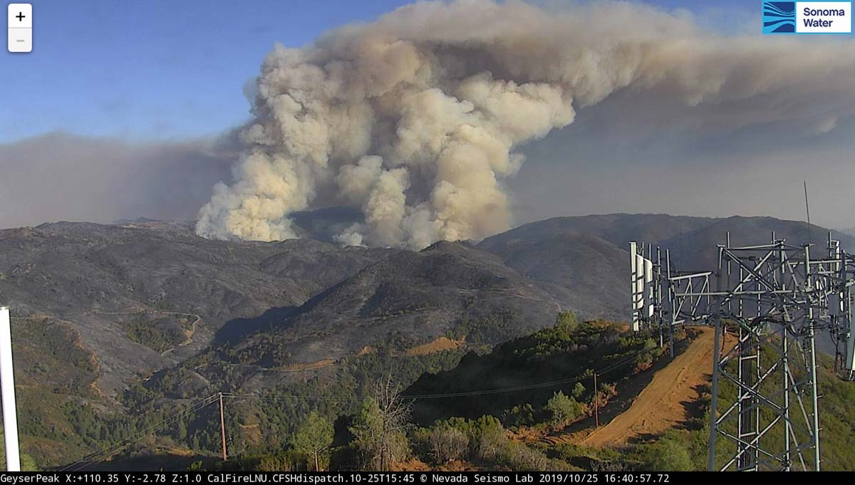
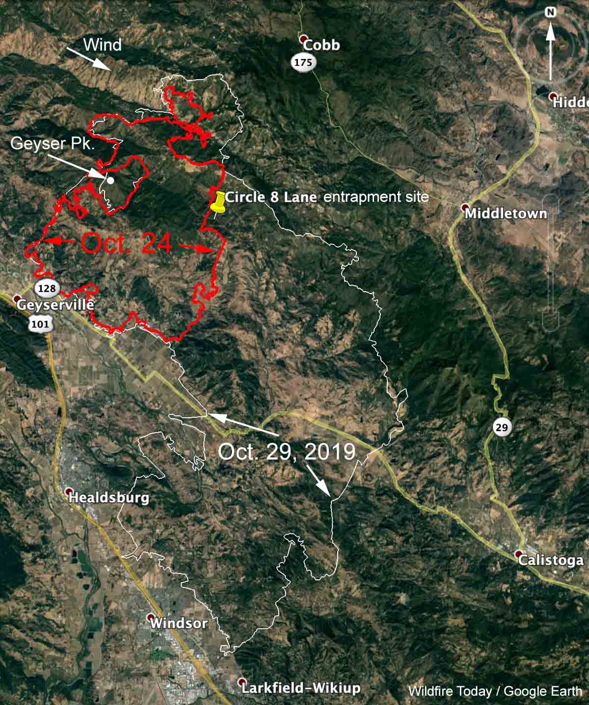
The California Department of Forestry and Fire Protection, CAL FIRE, has released a Green Sheet, or preliminary report, on the October 25, 2019 entrapment of one firefighter and two civilians. It occurred on the Kincade fire northeast of Geyserville, California about 43 hours after the fire started.
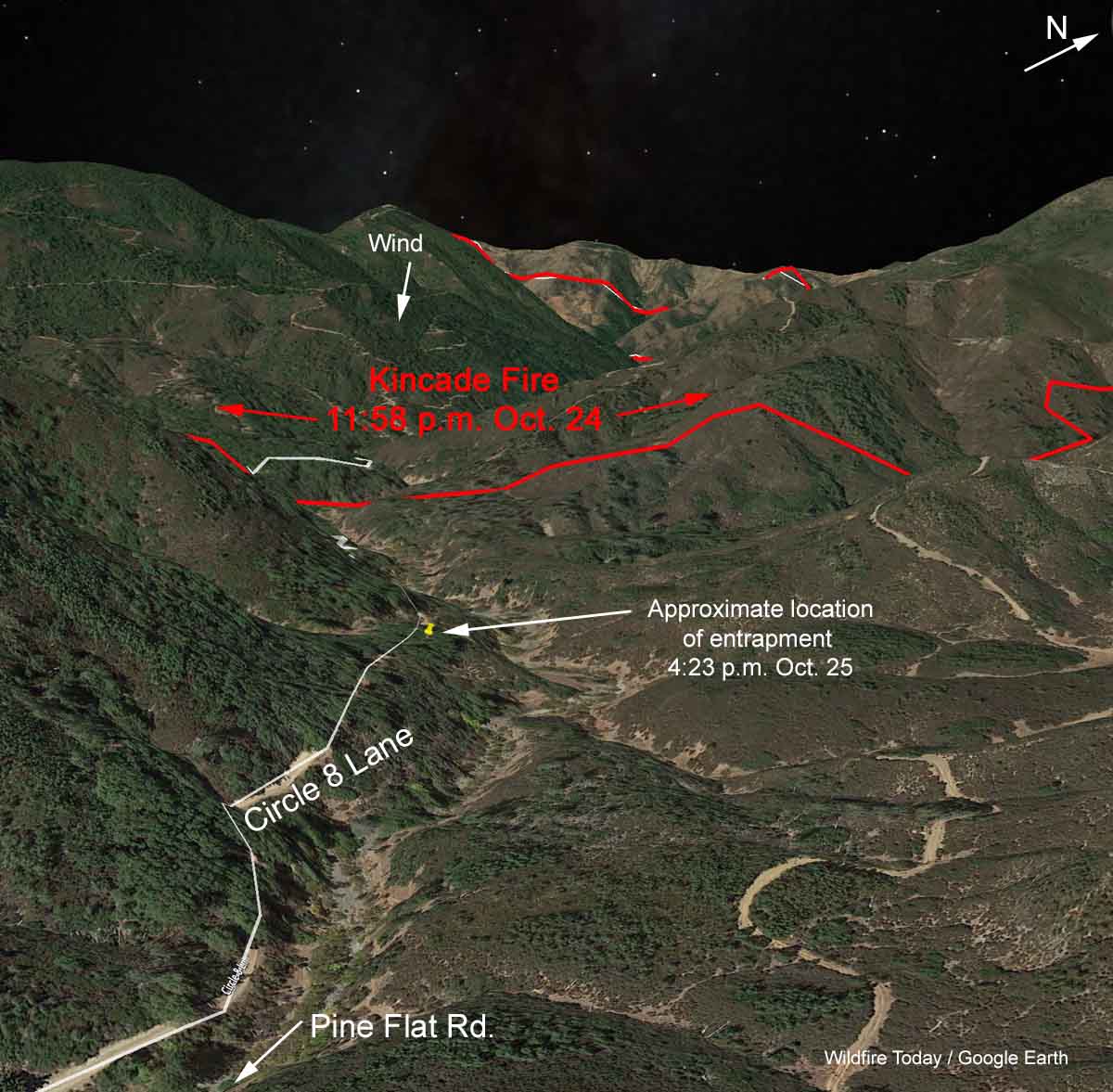
In mid-afternoon a Division Supervisor was scouting his division and searching for firefighters who he had been told were not wearing their Nomex wildland fire jackets. He turned his SUV off Pine Flat Road onto Circle 8 Lane, an unpaved road that reaches a dead end 1.5 air miles from Pine Flat Road.

Later, seeing that the fire intensity had increased and crossed the road behind him, he realized that he was in imminent danger and decided to ride it out near an old cabin. A dozer operator had already cleared a line around the structure as as well as a line from the road downhill to the drainage.
Below is an excerpt from the Green Sheet as well as more maps, photos, and a video. The Division Supervisor is identified as “DIVS1”.
At approximately 3:56 PM, DIVS1 radioed the Helicopter Coordinator (HLCO) and declared an immediate life-threat and requested bucket support. HLCO immediately declared an Incident Within an Incident and provided additional air support and requested the rescue helicopter from the helibase. HLCO also began the process of determining the location of DIVS1.
As fire intensity decreased the vehicle was backed westward and parked next to the cabin. Due to the smoky conditions, DIVS1 provided GPS coordinates to HLCO and guided them to the location. At approximately 4:04 PM, HLCO located DIVS1. HLCO advised DIVS1 this was a good location and said to remain there as the road was impassable. DIVS1 exited the vehicle. DIVS1 then prepared for a defensive firing operation out of concern for the spot fire burning above, dense unburned fuels, and the increasing fire activity in the drainage below the location.
Utilizing a fusee, DIVS1 conducted a defensive firing operation to create a larger area of refuge. The firing operation was initiated southeast along the downhill side of Circle 8 Lane, returning on the opposite side of the road. Firing continued around the cabin on the outside edge of the dozer line (Photo 2). At approximately 4:14 PM, as DIVS1 completed the firing operation, a pick-up truck with two civilians arrived at DIVS1’s location on the road and stopped behind DIVS1’s vehicle. These two civilians were traveling east toward the cabin site from another residence located at the end of Circle 8 Lane.
DIVS1 informed the civilians that their way out was cut off and told them they shouldn’t turn around due to increased fire activity behind them. The civilians were wearing t-shirts and pants. DIVS1 asked if they had any other clothing to put on in order to shield their skin from radiant heat. Civilian 1 grabbed a long-sleeve flannel shirt, but Civilian 2 did not have any other clothing. At first, DIVS1 considered using the cabin to shelter the civilians from the heat, but as the radiant heat from the fire increased, DIVS1 decided to use the fire shelter for protection. At approximately 4:16 PM, DIVS1 deployed the fire shelter on the road in front of the two vehicles and directed the civilians into the shelter. DIVS1 contacted HLCO and advised of the fire shelter deployment.
For approximately ten minutes, all three of them remained covered by the fire shelter. While under the fire shelter, they faced each other in a tripod-shaped arrangement in crouched positions, leaning forward, with heads tucked down. DIVS1 and the civilians noticed ember cast coming in under the shelter in areas where it was difficult to maintain a seal against the ground. DIVS1 periodically peeked outside the shelter as the fire burned around their location to assess conditions. Once the ember cast died down, DIVS1 exited the shelter and noticed the cabin was starting to ignite. DIVS1 relocated to a site further away from the cabin on the dozer line. When conditions were favorable, DIVS1 and Civilian 2 moved the vehicles away from the burning cabin to prevent them from igniting. HLCO supported their deployment location with 4 helicopters applying approximately sixteen water drops during the entrapment.
At 4:42 p.m. help arrived and the three individuals were evaluated by two Fire Line Medics and then transported to local hospitals in three ambulances that had staged on Pine Flat Road. All three were assessed and released later in the evening.
During the two days before the entrapment the area had been under a Red Flag Warning. A weather station 3.5 air miles west of the incident recorded the following data around the time of deployment: 84 degrees, 11% relative humidity, winds northwest at 12 mph with gusts up to 20. Prior to the incident, there had been a significant change in wind direction, from west shifting to come out of the north — in alignment with the drainage near the entrapment. (see the 3-D map above)
In addition, the Energy Release Component and Burning Index were at record high levels for the date.

An article in the San Francisco Chronicle identifies the Division Supervisor and includes the information that his family’s home on six acres in Paradise, California was one of the few that survived the Camp Fire in 2018.

The CAL FIRE video below, shot from a drone, shows the entrapment site.
You can download the entire CAL FIRE report by clicking here. (2.3 Mb)
Our comments:
The report is thorough, well written, and has enough information for the reader to get a clear picture of what happened.
It was very fortunate that the Division Supervisor had access to a GPS receiver.
Due to the smoky conditions, DIVS1 provided GPS coordinates to HLCO and guided them to the location.
The report did not specify if it was a stand-alone device or if he had an app on a phone that provided his coordinates. But without that data, the report appears to indicate that HLCO may not have been able to determine the location of the Division Supervisor. And, the four helicopters may not have been able to respond to the site and drop their 16 loads of water as quickly. Seconds matter during an impending burnover.
CAL FIRE is installing new communication equipment in some of their firefighting equipment that automatically transmits their location. Perhaps the SUV did not have the upgrade.
There is a web link in the Green Sheet that leads to on online survey, asking for opinions about the usefulness of the report. This is the first time I have noticed this in any report about an incident within an incident.
Thanks and a tip of the hat go out to Tom. Typos or errors, report them HERE.


Thank God for the DIVS and that he had GPS. Possibly an accurate GPS monitor could have saved the Granite Mountain Hot Shots on the Yarnell Hill Fire. If cell phones have a GPS sensor make sure all firefighting personnel are trained on their particular phone during preseason traing. Those who don’t have GPS should be issued a device. I like the idea of crews carrying extra fire shelters. Not only could civilians use them but crew shelters could get lost or torn. It was fortunate for the two civilians the DIVS was there, but should he have been there in the first place? How did he confirm there were firefighters out there without PPE? Did he know where they were? What happened to them? I remember the first thing I learned as brand new Hotshot in 1966 was the first Standard Firefighting Order: “Keep informed of fire weather conditions and forcasts.” Did he have a forcast? Did he apply it to where he was going? Did he or the Plans Section request a spot weather forcast? Bottom line for me is that he did a good job when he had to face a burnover.
For a decent look at the site put this in your browser:
https://www.google.com/maps/place/Circle+8+Ln,+California/@38.7464641,-122.7752274,265a,35y,232.97h,51.3t/data=!3m1!1e3!4m5!3m4!1s0x80840dbbcb8eddd1:0x5791266692b03af!8m2!3d38.7449784!4d-122.7790294!5m1!1e4
Any phone with google maps app on it can give you your location in less than a minute.
What was the bulldozer operator doing disturbing all the ground to the NE of the cabin? Making a place for an engine to turn around? To take shelter? (seems like a good idea). But this was a wind driven fire, a dozer line or 12 weren’t going to keep embers from starting the cabin on fire, so what was the point of him being out there? If this is normal procedure to put peoples lives at risk for a tiny chance at protecting someone’s cabin, no wonder fire fighters are called heroes.
It is a good thing 3 people can survive without burns under a shelter because despite all the stuff those trucks do have in them, apparently they don’t have extra shelters for emergencies like this.
So this DIVS is driving around looking for people who aren’t wearing their PPE? (the report never says whether they had PPE). For all of the high tech gear that exists, geography still stifles communication.
What was he going to do when he found them? Tell them to wear their gear and take the name of their supervisor who wasn’t doing their job? This is a problem that stems from the supervisor and their name is already known based on the assignment. I cannot understand how that level of baby-sitting was worth a DIVS time.
The level of service the folks in the field provide is astounding (smh in wonder).
As expected, excellent reporting by Mr. Bill Gabbert . I find his reporting informative as I live in a CA High Danger Fire Area. In June of 2017 (starting on 6/23), we lost several communities as a result of the Erskine Fire (Kern County, CA).
If all wildland FF s wore or carried a GPS that tankers could use for locating trapped ground crews , and pinpoint their locations , for more safer and precise drops . The yellow gets dirty and it’s gotta be tough to spot going 175 knots . Right?
The Divs1 Captain Hero is from my county. I am acquainted with him. He’s a brave, well trained, strong, dedicated, quiet, passionate, smart, modest man.
Thank Goodness he knew what to do in those two minutes with those two men.
It’s past my comprehension to think that a firefighter(s) wasn’t wearing issued nomax fire jacket (s)???? How is that even be imaginable or feasible? FF always have their jackets on even in 110 degree weather?
Our DIVS1 Capt was sent in to investigate? Putting his life at risk? Who were those guys and was it even true? What is that about? Very hard to believe.
I wouldn’t want to be the personnel involved if it’s true- the CALfire safety officer and Chiefs will have their hides.
The silver lining: Divs1 Capt saved two other lives cause he was on the scene.
These fires move FAST. Geez people, get out while you can.
I can’t help but think the Hand of The Holy Spirit was involved and our experienced well trained wildland FF Captain was the Guardian Angel for those fellas.
My heart goes out to his wife and children. They also sacrifice to keep us safe. The families of our FF need support too.
Wow, they were very fortunate not to be touched by fire which was not too far away from the cars and the cabin they stayed at.