North Carolina’s CL-215 being sold by company featured on reality show

You may remember when Wildfire Today told you last year that the state of North Carolina sold their CL-215 water-scooping air tanker on eBay for $445,099. Money was cited as the reason for unloading the aircraft, and at the time the state government was not overflowing with cash. David Lane, head of the forest protection for the state’s Division of Forest Resources, said it cost up to $1.2 million a year to operate, which was 35 percent of the division’s aircraft budget and they did not have the funding for an estimated $1.5 million needed for repairs and FAA-required maintenance.

North Carolina's CL-215 before it was sold in March
North Carolina's CL-215 before it was sold in March. State of NC photo.

There are several twists to this story.

The aircraft is now listed for sale by the new buyer for $3.5 million, almost eight times North Carolina’s selling price, but it remains to be seen if anyone will pay that price. The state bought the aircraft, which was manufactured in 1969, for $4 million in 1998.

North Carolina sold the air tanker a month before the 20,000+ acre Pains Bay fire started. Fire managers in the state loved the aircraft, and for 14 years had counted on the quick turn-around 1,400-gallon water drops it could make. It was replaced with some contracted single-engine air tankers that could also scoop water.

The company that bought the CL-215 on eBay, Buffalo Airways of Yellowknife, Northwest Territory, Canada has their own reality show on the National Geographic and History Channels called “Ice Pilots”. Buffalo has owned other CL-215s. We wrote about the show in August of last year when they aired a series of episodes in which the company had sold two of them to the Turkish government and were attempting to deliver them to the buyer, flying them across Canada, the north Atlantic, and Europe. (I never heard if they made it all the way to Turkey.) The Weather Channel has picked up “Ice Pilots” and is showing season three at 9 p.m. ET on Mondays. A fourth season is currently in production. You can watch full episodes of the show online at History Television (update, but it appears that only Canadians can view the online episodes).

The Charlotte Observer has more details about the saga of North Carolina’s CL-215.

Alaska Fire Management Officer in 40 (or so) seconds

Posted on Categories Uncategorized

As part of a new series of “Wildland Fire in 40 Seconds” videos that attempt to show the “many facets of wildland fire”, Dan Warthin, the Alaska Region Fire Management Officer for the National Park Service, accomplishes the feat in 51 seconds, including credits and titles.

We applaud the NPS for stretching its wings and allowing (or requiring?) their wildland fire employees to introduce themselves and their philosophy to the outside world. Another example is last year’s well done seven-minute video made by the NPS National FMO, Bill Kaage, about “emotional intelligence”.

Methinks this new 40-second video series is directed toward a population with an attention span that has been shortened and Twitterized by 140-character messages and SMS messages on cell phones. While it is a laudable concept to introduce wildland fire management and their managers to the world, it can be a very difficult task to accomplish something meaningful in 40 seconds.

We don’t know if there is any truth to the rumor that during the editing of this “Wildland Fire in 40 seconds” video, left on the cutting room floor were comments about being in favor of apple pie, motherhood and peace in the Middle East.

Update on Heartstrong fire in Colorado

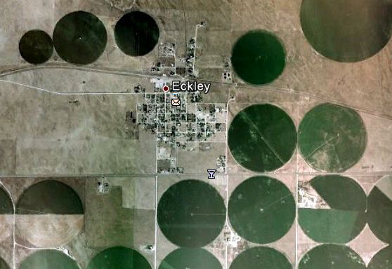
Eckley CO satellite photo
File photo from Google Earth of Eckley, Colorado in 2006.

UPDATE at 3:28 MT, March 19, 2012: The Colorado Division of Emergency Management issued this update at 1:20 p.m. MT today. Scroll down to see our original post:

==============================================================

Heartstrong Fire

Below is information received from GayLene Rossieter, Acting Fire Information Officer, Colorado State Forest Service.

(Updated 1:20 p.m., March 19)

Fire Jurisdiction: Yuma County

Location/County: South of Highway 34 between towns of Eckley and Yuma in Yuma County

Start Date: Sunday, March 18, approximately 1:15 p.m.

Cause: Under investigation, but potentially due to a downed power line from high winds

Acres/Land Ownership: Approximately 24,000 acres of half grass/crop fields on private lands

Containment: 100 percent

Evacuations: The evacuation order for the town of Eckley was lifted late last night; the approximate 200-square mile evacuated area around the fire was lifted today

Closures: Highway 34 reopened from the town of Eckley to County Road L

Injuries to Date: Three firefighters injured

Structures Lost/Damaged: Two homes destroyed; other structure damages still to be determined

Other Values at Risk: Number of livestock lost currently undetermined

Significant Events: High winds and thick smoke mixed with dirt decreased during the night, helping firefighter contain the fire. Today, fire crews and deputies drove through the burn area to manage hot spots and flare-ups. The Civil Air Patrol surveyed the extent of the fire’s damage earlier today.

Resources: Primarily local emergency response agencies, including nine volunteer fire departments and four other volunteer fire departments on standby. Regional agencies from northeast Colorado and western Kansas also assisted to control the fire.

=============================================================

Original post at 8:00 a.m. MT, March 19, 2012:

One of the firefighters that was burned on the Heartstrong fire in northeastern Colorado’s Yuma County (map) that Wildfire Today told you about yesterday was injured more seriously than first reported. Here is an excerpt from The Denver Channel:

Two firefighters were injured fighting the fire. One was treated for minor injuries on Sunday and released, [Deanna] Herbert [spokeswoman for Yuma County] said.

Another firefighter, Jennifer Struckmeyer, has second- and third-degree burns on her fingers, arms, side, leg and more. Her mother-in-law told 7NEWS when the firefighters were running back to the truck, Struckmeyer tripped and boot came off. Struckmeyer told her mother-in-law she prayed while the fire swept over her.

The fire continues to burn Monday morning but is 90 percent contained. It has burned at least two homes and approximately 53,000 acres but will be mapped more accurately today. The 200-300 residents that evacuated from the small town of Eckley were allowed to return Sunday night.

The 35-40 mph south winds with gusts up to 59 that pushed the fire yesterday decreased gradually during the night and are presently at 9 mph out of the west.

Colorado: homes burn and firefighters injured

The Associated Press and other media outlets are reporting that three firefighters have been injured while fighting the Heartstrong wildfire in northeastern Colorado’s Yuma County (map). The Colorado Division of Emergency Management retweeted Eric Hurst of 5280fire.com who said at about 5:30 p.m. MT:

Two fire trucks burned over and destroyed in Yuma County, 3 Firefighters have been injured.

Yuma County Sheriff Chad Day said one firefighter suffered minor burns to the face and was being treated at a hospital. A second firefighter was being treated for smoke inhalation, while a third suffered minor burns to the arms.

The fire started today at about 1:15 p.m. south of Yuma and spread toward Eckley, forcing 300 residents to evacuate.

Other news reports say that two or more structures have been destroyed in the wind-driven fire. CBS in Denver said that as of about 7 p.m. the fire was still active and that Highway US-34 east of Yuma was closed.

This afternoon a weather station at the Wray, Colorado airport about 12 miles east of Eckley, recorded a minimum relative humidity of 9% and 35-40 mph winds out of the south with gusts of 50-59 mph. Strong winds of 20-30 mph gusting at 28-40 are expected to continue until 3:00 a.m., after which they will decrease to about 11 mph.

Record-setting high temperatures in March

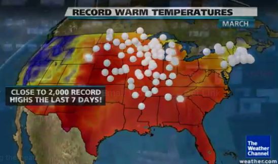
USA map record high temperatures
Map: Weather Channel

I continue to be amazed at the extraordinary, record-setting high temperatures across much of the United States. According to The Weather Channel, approximately 2,000 record highs have been recorded in the last seven days. One of the effects of this we are seeing is the wildfire occurrence occurring a couple of months earlier than normal in the Northern Rockies and Great Plains areas.

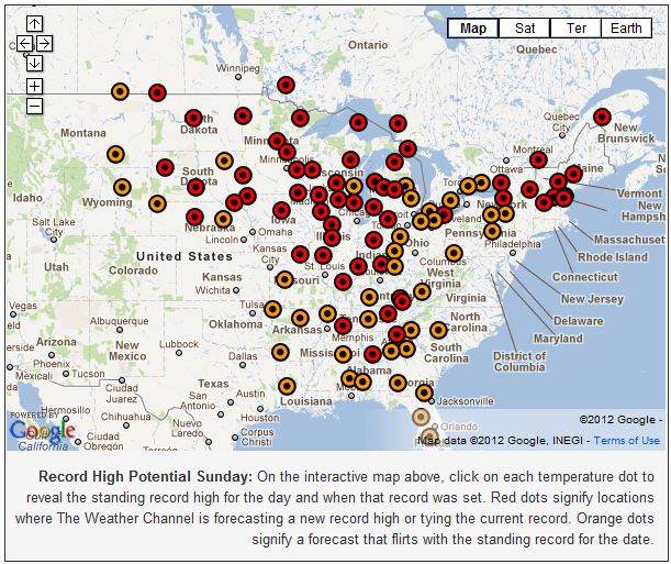
The map below is a screen grab of an interactive map at the The Weather Channel web site, at which you can click on a dot to see the high temperature predicted for today, March 18, and how much it will exceed the record high for this date.

Record high temperatures forecast 3-18-2012
Credit: Weather Channel

Some of the more notable high temperature records that are predicted for today include:

  • Bismarck, ND  +10
  • Williston Sloulin AP, ND  +12
  • Rochester, MN  +17
  • Houghton Lake, MI  +12
  • Burlington, VT  +13

On Wednesday the temperature in Traverse City, Michigan was 81, which was 42 degrees above the average for that date, and 4 degrees above the previous high, according to records that go back to 1897.

Prescribed fire along the Fall River

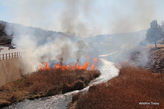
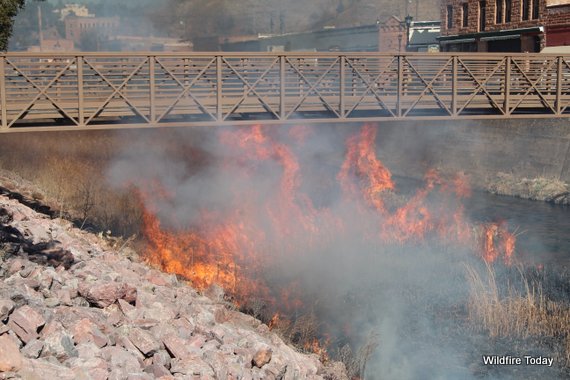
Fall River prescribed fire, Hot Springs, SDThe Hot Springs Fire Department annually conducts a prescribed fire along the Fall River flood channel in Hot Springs, South Dakota. This prevents woody vegetation from growing and clogging the waterway. The reeds and grasses grow back quickly.

Today the weather was almost perfect to reduce the fuels along the river and it burned very well. During the project the Red Canyon weather station about 14 miles to the west recorded the following conditions at 10:57 a.m. MT: 64 degrees, 28% relative humidity, and a south wind at 8 mph. Last year they conducted the burn on April 9. At that time the weather at the Hot Springs Municipal Airport was 43 degrees, with a relative humidity of 93%. And there was occasional drizzling rain.

Fall River prescribed fire, Hot Springs, SD

Fall River prescribed fire, Hot Springs, SD

More photos are below… Continue reading “Prescribed fire along the Fall River”