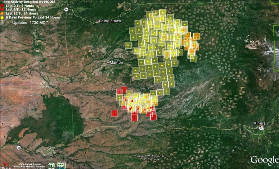
The Ponderosa fire 22 miles northeast of Red Bluff, California is causing evacuations of thousands of residents near the community of Mandan. According to CAL FIRE 15,000 acres and seven homes have burned since the fire started at around noon on Saturday.
The map above shows heat from the fire that was detected by a satellite Monday afternoon at 1:32 PT. The dark red squares indicate heat that was detected within the previous six hours.
At 7 a.m. Monday, CAL FIRE announced the following evacuations in the Manton, Shingletown & Viola areas:
- Forward Rd at Graham to the C Line
- Forward Mill Rd from Rock Creek Rd to Forward Camp Rd
- Rock Creek Rd from Manton Rd to Long Hay Flat Rd
- All of Long Hay Flat Rd and Woodcutter Way
- Southside of Highway 44 from Viola to Brush Oak
- Northside of Hwy 44 from Viola to Alward
- Hazen Rd area and South Power House Rd south of Manton
- Hwy 44 at Brush Oak east to and including Viola, Plateau Pines, Starlight Pines and Lake McCumber area
- South side of Hwy 44 from Viola to Brush Oak and on the north side of Hwy 44 from Viola to Alward.
In addition, CAL FIRE warned people in the area of Highway 36 at Oasis Springs Road to Lassen Lodge on both sides of the highway, which includes Ponderosa Sky Ranch, Canyon View Loop area and Lassen Lodge, of a potential threat to life and property. An evacuation warning considers the probability that an area will be affected and prepares people for a potential evacuation order.
The weather through Tuesday will not be extreme, but the wind direction will shift several times pushing the fire in various directions, challenging firefighters to remain safe. Monday night the wind will be out of the southwest at 6-10 mph, shifting to the southeast and then from the east Tuesday morning, and finally changing to a 13 mph southwest wind by noon on Tuesday.

photos of this fire
http://calemanews.wordpress.com/2012/08/23/photos-images-from-the-ponderosa-fire/
The CalFire incident page for the Ponderosa Fire is at http://tinyurl.com/d3p8to3 . It’s current showing a last update of August 21, 2012 7:15 am (which makes it about 11 hours old as of this posting). The last published fire perimeter (about 10 hours old as of now) is under the “Incident Maps” link on the left-hand side.
Hope you are able to update this map. Information from CalFire, our local TV/radio/newspaper is virtually non-existent, out-of-date or so vague that it is impossible to get accurate, up-to-date descriptions of the fire. In 3 days of searching the internet, the map you posted is the best information I have found where locals can actually see the path of the fire.
Thank you.
thank you for posting such valuable info as i used this website for the colorado wildlfires and now for the ponderosa fire in california.. . I am a volunteer wildlandfire scanner transcriber and the more correct info we get to folks to the better.
Joann:
Are the wildlandfire scanner transcriptions available to the public?
yes i use either radio reference go to http://www.radioreference.com click on california and then the county you want
for the ponderosa fire up north you will need the scancal.org scanner
http://www.scancal.org / you need to heave real player on your computer download this and you can listen to the scanner with your speakers on your computer .. right now talk on scanner for the ponderosa fire is getting the 2 dc 10s to work today over the fire .. hope this helps