
Updated at 7:11 p.m. PT Jan. 22, 2022

The Colorado Fire north of Big Sur, California was mapped at 683 acres by the Fire Integrated Real-Time Intelligence System (FIRIS) aircraft at about 5 p.m. Saturday. This is less than half of the earlier 1,500-acre estimate by the California Department of Forestry and Fire Protection. Fires look larger at night and the terrain at the fire scene is very rugged and difficult to map from the ground.
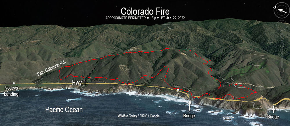

A satellite overflight at 1:22 p.m. local time showed that the fire had spread on the south side near Rocky Creek and on the northwest side southeast of Notleys Landing south of Palo Colorado Road. There has been no indication that the fire has crossed Highway 1, reached the coast, or made any large runs on Saturday afternoon. The fire cameras in the area did not pick up any large smoke columns.
1:04 p.m. PT, Jan. 22, 2022
A wind-driven wildfire that broke out Friday afternoon north of Big Sur, California has prompted evacuations. The fire just east of the Pacific Coast Highway has forced residents to leave their homes and officials to close a portion of the iconic highway.
The blaze started near Palo Colorado Canyon Road which led firefighters who usually name a fire after a local landmark, to call it the “Colorado Fire.” (A name which will likely result in confusion.)

Monterey County has created a map showing evacuations in effect.
The incident is nine air miles north-northwest of Big Sur and seven air miles south of Carmel Highlands.
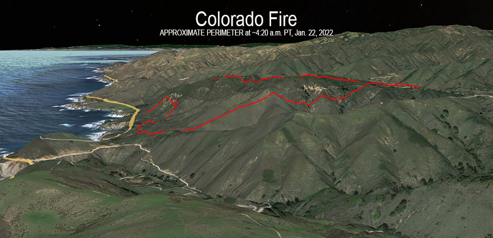
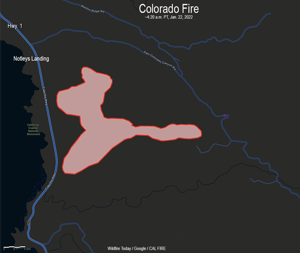
At 8:19 a.m. on Saturday the California Department of Forestry and Fire Protection said it had burned about 1,500 acres, but that figure is subject to change. At 12:30 p.m. PT there were several CAL FIRE S-2T air tankers flying near the fire.
The Colorado Fire was pushed Friday evening by very strong winds out of the northeast, measured at 41 mph gusting to 52 mph at 5 p.m. at the Old Coast Tower weather station east of Point Sur. The relative humidity was 21 percent. This caused the fire to spread west and southwest, cresting the ridge east of the Pacific Ocean; then the wind shifted. After 9 p.m. it decreased to 10 mph from the south and southeast. Around dawn on Saturday it shifted again, from the north and northwest at 5 to 8 mph. Overnight the humidity rose to 60 percent but dropped to about 30 percent at 11 a.m.

The #ColoradoFire burns above the Bixby Bridge as dawn breaks in Big Sur. https://t.co/780SXnHe2P via @mercnews pic.twitter.com/MIUZmQJgRV
— Karl Mondon (@karlmondon) January 22, 2022
Thanks and a tip of the hat go out to Pat.

Good example of a lot of potential, if not for the Soberanes burn (and, to a certain extent, time of year). Large old burns (generally speaking, less than 10 years) will help keep many fires from getting big.
Well…THAT certainly has nowhere to go.
Just in case anyone is curious about winter fire in CA, here is a good article with some factual information, I spent most of my career in CA and recall fighting fire in Dec and Jan, did not occur very often, Feb, March and April very rare do not recall any assignments. These are the typical green up months in So Cal. Wind/RH will override many factors when it come to the ROS. ie. FM
https://www.eastbaytimes.com/2022/01/22/winter-fires-such-as-one-near-big-sur-unusual-in-california/
Weather should get better in the next few hours and the rest of the week…
Discussion from KMTR
It`s been a busy day due to the fire activity last night and into
today. With winds remaining gusty across North Bay Hills, it`s
still wise to be cautious in any activities that could produce a
spark. Because even if winds fall below High Wind Warning
criteria, they can still help spread fire should there be any
starts. Good fire news is that the Geysers Wildfire in Sonoma
County was contained this morning. And while the Colorado Fire in
Big Sur continues, the forecast calls for light winds ranging 5-10
mph through the rest of the weekend and light onshore flow this
afternoon, then again Sunday afternoon, should help boost
humidity levels.
It appears the fire hasn’t gotten into Palo Colorado Road. As rustic and beautiful as it is the pines and other vegetation grows thick among wooden cabins many years old. There is one complex of buildings in a remote area that could have been in the fire’s path. Monterey County has provided excellent evacuation maps and updates.