A September 16 update on the Butte Fire is in a new article.
****
(UPDATED at 12:17 PT, September 14, 2015)
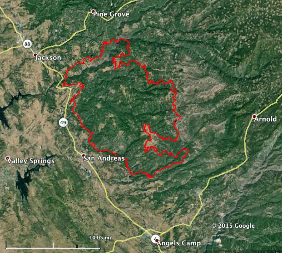
The Butte Fire south of Jackson, California has grown by about 6,000 acres in the last two days and is now listed at 71,063 acres.
CAL FIRE reports that 135 residences and 79 outbuildings have been destroyed.
Fire behavior remained moderate on Sunday allowing crews to be more effective in constructing fireline on the perimeter.
Evacuations are still in place for many areas in Amador and Calaveras Counties. More details are available at the fire information phone lines: (530) 647-5218 and (209) 754-5527.
****
(UPDATE at 10:35 p.m. PT, September 12, 2015)
In a 9:15 p.m PT update from CAL FIRE, the size of the Butte Fire south of Jackson, California remained about the same during the day on Saturday, but damage assessment teams reported that they counted 86 homes and 51 outbuildings that burned in the fire.
Mandatory evacuations are still in place for numerous locations in Amador and Calaveras Counties. More details are available at the fire information phone lines: (530) 647-5218 and (209) 754-5527.
Over 3,800 personnel are assigned to the fire, along with 452 fire engines, 77 hand crews, 17 helicopters, and 94 dozers.
****
(UPDATED at 9:43 a.m. PT, September 12, 2015)

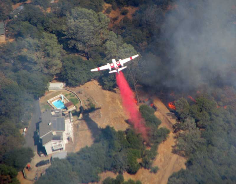
Two close calls have occurred on the Butte Fire south of Jackson, California. A truck from the West Point Fire Protection District burned in the private driveway of a home along Highway 26 . The person who took the photo above said it appeared the crew was doing structure protection and that they were able to avoid any major injuries.
The Modesto Bee has an article about “Modesto and Stanislaus Consolidated crews” that had to take refuge behind a structure as the fire “made a significant run at them [with] very erratic fire behavior”. The firefighters did not deploy fire shelters, but their vehicles suffered heat damage described as “cosmetic”, including “bubbled paint, melted plastic trim and melted hose”.
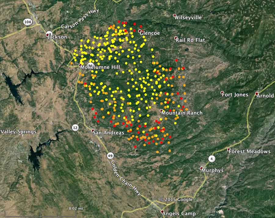
CAL FIRE reports that the Butte Fire has burned 64,728 acres and has destroyed 15 structures. Other than evacuations and the number of firefighting resources assigned (3,330 personnel) CAL FIRE has provided little additional information about the fire. Saturday morning they did supply the map below which, although undated, appears to be fairly current.

****
(UPDATED at 5:30 p.m. PT, September 11, 2015)

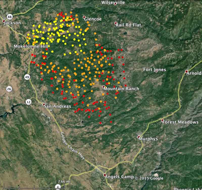
CAL FIRE reported at 3 p.m. today that the Butte Fire south of Jackson has burned 50,000 acres since it started 46 hours before on September 9.
More areas have been added to the mandatory evacuation list in Calaveras and Amador Counties. Details are available at the Fire Information phone line, (530) 647-5218 and (209) 754-5527.
****
(UPDATED at 9:37 a.m. PT, September 11, 2015)

The Butte Fire south of Jackson, California continued to grow during its second day on Thursday, spreading primarily to the south and southeast. (see the map below)
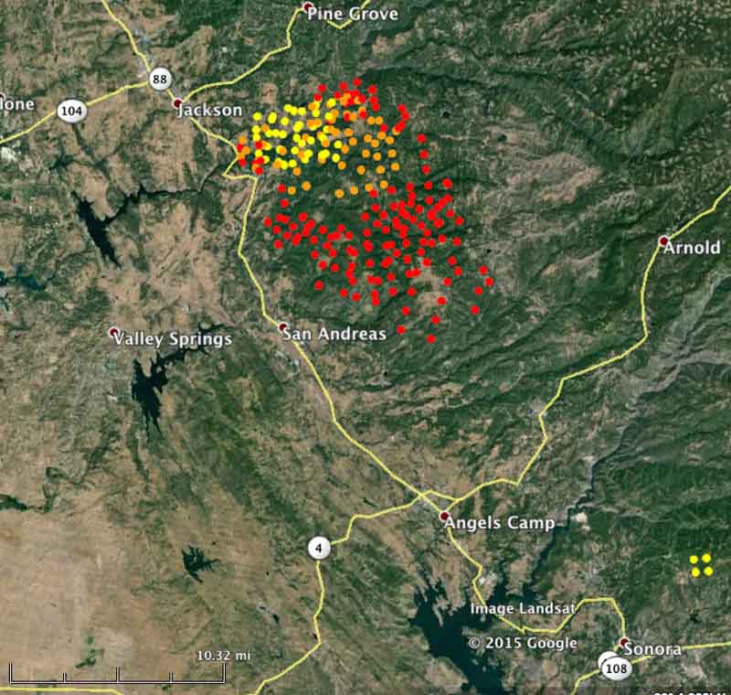
CAL FIRE reported Friday morning at 6:43 PT that the Butte Fire had burned 31,974 acres.
Evacuations have been ordered in numerous locations in Calaveras and Amador Counties. Details are available at the Fire Information phone line, (530) 647-5218.
CAL FIRE has not updated the number of structures burned since Thursday morning, when they reported “6 structures and 2 outbuildings destroyed”.
****
(UPDATED at 10:02 p.m. PT, September 10, 2015)
About four hours after CAL FIRE said that the Butte Fire southeast of Jackson, California had burned 4,000 acres, an update at 6:30 p.m. reported that it had more than tripled in size, to 14,700 acres. There was no update on the structures burned, still remaining at six, but with the extreme fire behavior experienced Thursday afternoon, that number could grow after it is possible to assess the damage.

CAL FIRE described the fire as having “rapid, uncontrolled fire growth” and said “suppression efforts had minimal impacts due to a high focus on structure defense.”
****
(Originally published at 3:54 p.m. PT, September 10, 2015)
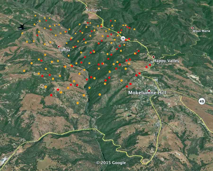
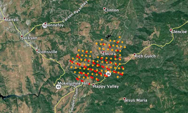
A fire that started Wednesday afternoon southeast of Jackson, California has burned at least six structures and approximately 4,000 acres. As of early Thursday morning it was about 4 miles southeast of Jackson and was very close to Mokelumme Hill, Happy Valley, Electra, and Rich Gulch. (see the two maps of the fire)
Thursday afternoon it was very active, crossed Highway 26, and was being fought by multiple large air tankers, including two DC-10s and a large number of firefighters on the ground.
There was a report Thursday afternoon that firefighters in at least one location on the fire found their safety compromised due to extreme fire behavior Thursday afternoon and requested air support.
Evacuations have been ordered in several locations in Calaveras and Amador Counties. Details are available at the Fire Information phone line, (530) 647-5218.

What time did the fire start and finish its major runs on 11 September?
Nice piece of fire journalism. I liked your depiction of the fire progression day to day. Well done from another fire behaviour analyst in Australia.
Did it hit spring lake road in Mokelumne Hill?
Any updates on Spring Lake Road? Can’t reach family members.
Hi there, we live on spring lake road. Who are you looking for?
Bill, thank you for this excellent and up-to-date information.
You’re welcome, Sarah.
about 6:23 calfire reported 64,728 acres with containment down to 5%
Bill–Butte Fire may soon enter my old CAL FIRE Battalion (4414: Arnold Battalion) Upper Murphy’s, Avery, Arnold areas. Fuels have not burned in that area since 1992–Heavy continuous Fuel Models 6,10 and 14 under sever drought stress. It will get worse before it gets better in the Upper Mountain Ranch and Murphy’s Area to the SE–very steep rural interface ground to the North, East and South of San Andreas. Glad to be retired in Montana!
hey all,just saw on KCRA3,a video with a burned out engine ,it seems to me to have been a small IA type grass rig,my old department a pierce with a dodge chassis and the pierce body,was a one ton,I loved it myself,myself and another guy did a knock down on a structure fire.the crew has been reported to have made it to safety in time.
50,000 acres about 2 or 3pm
September 11, 2015 2:20 pm
Date/Time Started: September 9, 2015 2:26 pm
Administrative Unit: CAL FIRE Amador – El Dorado Unit
County: Amador & Calaveras Counties
Location: Butte Mountain Road, east of Jackson
Acres Burned – Containment: 50,000 acres – 10% contained
Structures Threatened: 6,000
Structures Destroyed: 6 structures and 2 outbuildings destroyed
Evacuations:
Residents of the town of San Andreas are being placed on mandatory evacuation immediately due to explosive fire conditions in the area. Emergency personnel are asking everyone to leave the area and NOT to shelter in place.
Residents in the Westpoint and Railroad Flats area should exit the area Northeast towards SR 26 to Pine Grove. Emergency officials are asking that all residents adhere to these exit routes for public and emergency personnel safety.
50,000 acres now per CalFire 09/11/2015 after 2pm.
from CalFire
BUTTE FIRE
Butte Fire Incident Information:
Last Updated: September 11, 2015 9:00 am
Date/Time Started: September 9, 2015 2:26 pm
Administrative Unit: CAL FIRE Amador – El Dorado Unit
County: Amador & Calaveras Counties
Location: Butte Mountain Road, east of Jackson
Acres Burned – Containment: 50,000 acres – 10% contained
Structures Threatened: 6,000
Structures Destroyed: 6 structures and 2 outbuildings destroyed
Evacuations: Mandatory Evacuations are as follows:
(Amador County) Canyon View, Fig Tree Lane, and Ponderosa Way; The Town of Pine Grove to include all areas South of Hwy 88 at Ranch Road and East of West Clinton and Easy Bird Road, Sierra Lane, Thadeus Court, Center Street; SR 26 from Hwy 49 to Railroad Flat to include all sides of the street; Jesus Maria from Hwy 26 to Railroad Flat to include all side streets North of Jesus Maria and South to Doster Rd/West Murray Creek Road and East of Hawver Road.
(Calaveras County) Communities of Glencoe and Wilseyville; Lower Dorray Road; Jesus Maria from Hwy 26 to Railroad Flat to include all side streets North of Jesus Maria and South to Doster Road/West Murray Creek Road and East of Hawver Road; Ridge Road North to SR 26, Associated Office Road, Woodhouse Mine with Railroad Flat as Eastern Boundary; Hawver Road at Gold Strike East to Doster Road; Whiskey Slide Road North of Mountain Ranch Road to Jesus Maria/Whiskey Slide East to Railroad Flat Road.
Evacuation Warnings: (Calaveras County) Town of Mountain Ranch South of Mountain Ranch Road and Alpine areas of Mountain Ranch; Sierra Vista Lookout Road, West Murray Creek Road to Doster Road, Murray Dale Lane (entire road); Leonard Road Subdivision.
Evacuation Centers: Jackson Rancheria Hotel, San Andreas Town Hall, Calaveras County Fairgrounds
Large Animal pet shelters (Calaveras) Calaveras County Fairgrounds
(Amador) Amador County Fairgrounds, contact Kelly Reason at 530-503-5233
Road Closures:(Amador County) Clinton Road at Butte Mountain Road (Both Ends) Butte Mountain Road Cutoff at Clinton Road. Amador Lane at Clinton Road, Electra at SR 49, Ponderosa Road at Tabeaud, Access to Lake Tabeaud is closed; Hwy 88 at W. Clinton Road, Hwy 88 at Irish Town Road, Hwy 88 at Tabeaud Road, Hwy 88 at Aqueduct Circle, Highway 88 at Mount Zion.
(Calaveras County) SR 26 from Mokelumne Hill to Ridge Road; Ridge Road closed to Railroad Flat Road; Railroad Flat Road closed to Mountain Ranch Road; Mountain Ranch Road closed to Hwy 49; Michel Road is closed.
Cause: Under Investigation
Cooperating Agencies: Cal OES, USFS, BLM, PG&E, CHP, Calaveras County Sheriff, Amador County Sheriff, Calaveras PUD, CDCR, Sutter Creek Fire Department, Red Cross, CAL-TRANS, CA State Parks, Amador Fire Protection District.
Total Fire Personnel: 1,571
Total Fire Engines: 178
Total Fire crews: 38
Total Airtankers: 7
Total Helicopters: 16
Total Dozers: 21
Total Water Tenders: 7
Incident Management Team: CAL FIRE Incident Management Team 1
Long/Lat: -120.70418, 38.32974
Conditions:
The Butte Fire affecting the Counties of Amador and Calaveras has burned more than 50,000 acres in the past 48 hours. Due to extreme weather conditions, steep topography, and a historic 4-year drought, the Butte Fire is experiencing unprecedented fire conditions and growth.
On behalf of CAL FIRE Incident Management Team I Incident Commander Phill Veneris, the public is advised that evacuation orders issued by the Calaveras and Amador County Sheriffs continue to expand. With explosive fire conditions, the Incident Commander Phill Veneris states “please stay vigilant and adhere to all evacuation orders. You are also advised that if you see smoke or fire approaching your community, evacuate the area immediately to a safe location.”
Evacuation Centers:
Jackson Rancheria Hotel
Calaveras County Fairgrounds
Phone Numbers (530) 647-5218 (Fire Information Line)
Phone Numbers (209) 754-5527 (Fire Information Line)
Scanner: Sounds like they’ve now got evacuations S to Angels Camp, E to Avery – everything east of hwy 49; N of 4, and clear up to pine grove area on hwy 88. A lot of civilians hadn’t yet evacuated up on Mountain Ranch road area and so they’ve apparently got them huddled in safe places in meadows.
I’m waiting for certain parts of the population to comment that “if only we were allowed to harvest timber, this fire could have been stopped at Initial Attack”, even if it’s not burning on Federal Lands or in a timber fuel type!
The photo of the S-2 retardant drop should be a classic for insurance companies to explain what “clearing limits” are and are not.
14,700 acres at 7pm…10,700 acres in 12 hours……the sky over my home turned black around 2pm..there was no sun to be seen by 6pm