(UPDATED at 1:15 p.m. PST November 11, 2018)
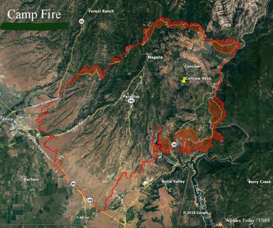
The Camp Fire at Paradise, California continued to be very active Saturday and Saturday night. The areas spreading the most were the north and east sides. Around Big Bend north of Lake Oroville, the fire moved 0.5 to 1.0 mile. CAL FIRE reports that the fire has covered 109,000 acres.
(To see all articles on Wildfire Today about the Camp Fire, including the most recent, click here.)
After gusting at 10 to 22 mph overnight, the winds on the Camp Fire slowed considerably after sunrise Sunday, and came out of variable directions at about 2 mph.
Forecasters expect the wind to increase Sunday night out of the northeast at 17 mph, gusting to 24. The humidity will be in the lower teens late Sunday afternoon, increasing to 21 percent during the night. The fire activity could increase Sunday night. The wind speeds should decline to about 5 mph Monday afternoon.
The number of people that died in the Camp Fire in northern California has risen by 14, the Butte County Sheriff’s Office confirmed Saturday night. With the nine found earlier, this brings the total to 23. The victims have been found near residences and in the burned ruins of vehicles and homes in Paradise and Concow. It is possible that these numbers will increase in the coming days.
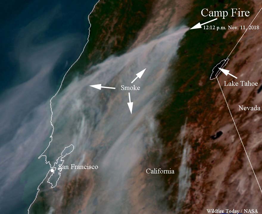
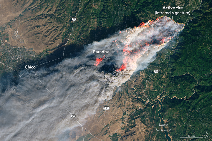
The fire is still producing a prodigious amount of smoke which is moving off to the south and southwest.

Below is a Sunday morning update from CAL FIRE:
“Last night the fire conditions were moderate to extreme due to the wind event. Crews continued to protect structures and fight fire aggressively. Fire lines are strategically being put in ahead of the fire to improve roads and provide barriers to the fire. Today [Sunday] the fire and firefighters will continue to be impacted by the strong winds. With the northeast wind pushing smoke to the southwest air operations will take advantage of the clearer air on the eastern side of the fire as long as weather and smoke conditions permit. Firefighters and cooperating agencies are continuing to mitigate many hazards within Paradise, CA.
“At 0700 hrs [Sunday] morning the Camp Fire Incident entered unified command with USFS.”
(UPDATED at 9 p.m. PST November 10, 2018)

The number of people that died in the Camp Fire in northern California has risen by 14, the Butte County Sheriff’s Office confirmed Saturday night. With the nine found earlier, this brings the total to 23. The victims have been found near residences and in the burned ruins of vehicles and homes.
None of them have been positively identified due to the condition of the remains. The California Department of Justice will help set up a process whereby relatives can give DNA samples to assist with identifications.
At least 110 are still missing.
CAL FIRE reports that the Camp Fire has burned 105,000 acres.
These abandoned and burned out cars shows you what a panic it must have been for residents trying to escape the Camp Fire. Unreal scenes in Paradise, CA, this morning. #CampFire pic.twitter.com/AhBuWzS0Tx
— Nick Valencia (@CNNValencia) November 9, 2018
(Originally published at 8:22 a.m. PST November 10, 2018)
The news from the Camp Fire that burned through Paradise, California keeps getting worse. Authorities reported that four additional fatalities are confirmed, bringing the total to nine. Some of the nine were found in burned vehicles, others were on the ground near structures, and one was discovered in a residence.
(To see all articles about the Camp Fire on Wildfire Today, including the most recent, click here.)
Officials reported that 6,453 homes and 260 other structures have been destroyed, making the Camp Fire the most destructive in California history.
The number of fatalities and burned structures could increase in the coming days as firefighters are able to access more areas.

The mayor of the town of Paradise estimates that 80 to 90 percent of the structures were wiped out.
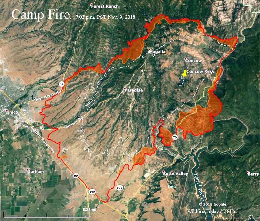
On Friday the north half of the fire was actively spreading, including the northernmost edge, areas west of Magalia, near the northwestern arm of Lake Oroville, and the fire edge east and south of Concow Reservoir.
CAL FIRE is saying the Camp Fire has burned 100,000 acres.
Pacific Gas & Electric disclosed to the Public Utilities Commission that one of their high voltage power lines had a disruption in service on Pulga Road near the Camp Fire at 6:15 a.m. the day it started. The fire was reported at 6:29 a.m.
Resources assigned to the fire include 440 engines, 18 water tenders, 23 helicopters, 67 hand crews, and 67 dozers for a total of 3,223 personnel.
Description of the video below: “Leaving Paradise, California towards Chico down Pentz Rd the morning of Friday, November 9th. This is the area around Lime Estates.”

The wind was blowing away fron highway 70 by big bend why did calfire set a back fire there
My wife was at feather river hospital no fire alarms she has to.ask a.nurse about the smell of smoke thats when she was told to evaluate
The traffic leaving the hospital should of went down pentz she turned ar the stop sign went to skyway direction with the fire coming from the north side almost broadsided her.
Who got contracts up there for logging ,mining
Why wasnt small local business hired owner operater .
Im dont everything that went on if im wrong aboit anything please update me
Gary Glotfelty Palomar Hot Shot Superintendent from 1975 thru 1978. Stayed behind in Paridise saved his home. Gary had prepared his property for years to protect it. He’s safe and his family is safe
Hello, I’m asking for a friend of mine who is extremely worried his house has burned down. He lives in Magalia. Are there any structures left in Magalia? Thank you for your time.
I received an email this morning around 5am from Mike McDonald from Bob Praytor, that Kit Bailey made his way to Gary’s house and confirmed the same.
No doubt that Gary would be prepared, an would make a stand.
Yep, that sounds like Gary. Thanks for the info, Barry.
Thank you so much for posting this. We are longtime friends of the Glotfeltys and we have been frantic about them since the news started. They are not registered on the Red Cross’ Safe and Well list. I am so relieved to hear they are all right.
Barbara Lopez and family
An agency rep from California OES was asked to locate him and they did he is fine