Updated at 4:47 p.m. PDT June 27, 2021

The Lava Fire three miles east of Weed, California was mapped by a US Forest Service Cobra Firewatch helicopter at 1:44 p.m. PDT Sunday and determined that the fire had burned 410 acres.
(To see all articles on Wildfire Today about the Lava Fire, including the most recent, click HERE.)
The high temperature at a weather station northwest of the fire at about the same elevation recorded a high temperature as of 3:53 p.m. of 93 degrees, but still appeared to be rising. The relative humidity in the afternoon was in the teens, the wind speed was 2 to 5 mph, and the direction, as predicted, was all over the place.

Sunday afternoon the Lava Fire was putting up an impressive pyrocumulus-topped convection column. The light wind allowed the column to build directly over the fire.
On Monday that breeze will be replaced in the afternoon by strong winds out of the south at 17 mph gusting to 28 while the temperature rises to 96 degrees with 15 percent relative humidity…. a recipe for significant fire growth unless firefighters can get a line around the fire before noon.
Updated at 8:12 a.m. PDT June 27, 2021

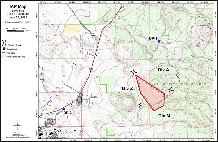
The Lava Fire near Weed, California was active all night Saturday. A satellite overflight at 3:18 a.m. Sunday showed that it had spread approximately 1 mile further to the south in the previous 12 hours making the overall length about two miles. (See the map above)
Saturday evening the Incident Management Team reported it had burned 220 acres. The heat signatures detected by the satellite at 3:18 a.m indicated that it had grown to at least 400 acres.
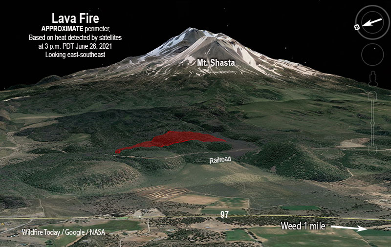
At 3:18 a.m. Sunday the Lava Fire was still approximately three miles east of Weed and had stayed east of the railroad tracks.


Very little information is being made available about the Lava Fire on the Shasta-Trinity National Forest. Some systems that receive and display data about wildfires are showing little or nothing about this incident. The fire was reported Friday morning, and Sunday morning the National Situation Report shows no resources assigned, but almost half a million dollars have been expended. After 48 h0urs, no accurate map has been released, and apparently it has not been mapped by Federal or contracted infrared aircraft. This is the only large uncontained wildfire in Northern California, so there should be an adequate supply of resources to manage this fire. Unless — the degradation of Federal firefighting personnel that has received so much attention in recent weeks is showing up already on this 400-acre incident. Maybe the flow of information will improve after the Type 2 Incident Management Team assumes command, presumably on Monday.
9:56 p.m. PDT June 26, 2021

The Lava Fire, reported Friday morning at 8:24, became much more active Saturday three miles northeast of Weed, California. It was chewing through timber in the Shasta-Trinity National Forest, pushed by moderate winds out of the north and northwest while the relative humidity dropped into the single digits in mid-afternoon and the temperature rose to 100 degrees at the BOLMWS weather station northeast of the fire.
According to satellite heat sensing data at 3 p.m. Saturday it had spread at that time for about a mile after apparently starting just south of a railroad.

The Siskiyou County Sheriff has issued an evacuation warning for some areas along Highway 97 north of Weed, including Angel Valley Road, Carrick Addition, and Solus Drive. This is not an actual evacuation. People in these areas need to be prepared to evacuate if it becomes necessary.
The US Forest Service reported at 8:29 p.m. Saturday that the estimated size was 220 acres. The suspected cause is lightning.
A Type 2 Incident Management Team has been ordered for the incident and will be in-briefed Sunday evening.
Fire officials reported a drone incursion over the fire Saturday afternoon which halted aerial operations for a brief time. Flying drones near a fire is illegal. Remember “If you fly we can’t.”
Four large air tankers were seen Saturday on an aircraft tracking app flying from Redding taking multiple loads of retardant to the fire — two MD87’s, an RJ85, and a MAFFS military C-130. Two MAFFS have been activated and their first day on the job was today, Saturday. They were initially based at Sacramento McClellan Airport in the morning but were reloading at Redding with the other three large air tankers.
An Excessive Heat Warning is in effect for the fire area until 11 p.m. Thursday.
The weather forecast for the fire area Saturday night is for 3 to 5 mph north-northeast winds switching to come out of the southeast after 11 p.m. For Sunday the prediction is for 3 to 7 mph winds from variable directions with 99 degrees and 14 percent relative humidity. Monday afternoon the area is under a Fire Weather Watch which could lead to significant fire spread. The forecast is for the wind to be from the south at 15 mph gusting to 23 mph with the relative humidity in the mid-teens and a high temperature of 97 degrees.
The name of the fire, Lava, does not mean it started from an active, hot lava flow. Lightning is the suspected cause.


THIS ” LAVA ” FIRE IS SURROUNDED BY ( 2 ) WEED AREAS — THE TOWN OF WEED ( NAMED AFTER ABNER WEED , LOCAL LUMBER BARON ) AND THE ” SHASTA VISTA WEED ENVIROMENTAL DISASTER AREA ” — THE SHASTA VISTA WEED SITE IS A SORRY MESS — ITS MOSTLY 1 ACRE PARCELS , HUNDREDS OF THEM , EACH ONE BOUGHT BY A DRUG CARTEL MEMBER — EACH PARCEL CONTAINS A FEW NARCOTIC GROWING HOTHOUSES — THE LEADER OF THESE NARCO-TERRORISTS IS PRESENTLY ENJOYING THE HOSPITALITY OF THE SISKIYOU COUNTY JAIL — 3 MILLION DOLLAR BAIL — SO RIDDLE ME THIS , WHY IS CALFIRE TRYING TO SAVE THAT AREA ? DO THEY GET A CUT OF THE PROCEEDS ?? — AS CHEECH AND CHONG WOULD SAY ” LET IT GO UP IN SMOKE !! ” — POSTSCRIPT — DRUGS ARE PASSE IN TODAYS ENLIGHTENED SOCIETY — SEE THE LIGHT !!
I hope you are able to get that caps lock key fixed.
Vernon, you don’t know enough about the situation. Yes Shasta Vista is all that you say and more. The forest service was and is in control of this fire that could have been stopped if Cal fire would have been allowed to also help. Their hands were tied. I know because 4 of my family members are Cal fire and live in Lake Shastina. They are just trying to protect the communities with houses, and couldn’t give a rat about the drug cartels. How insulting of you to spew this garbage.
Eyewitnesses confirm from Friday morning that this fire was not aggressively attacked from the start! WHY??
Satelite has dimensions of the hole is it going to grow I think we do we should be prepared as so as possible.
How can we reach out family in weed ca. I’ve been trying since 9 this morning..
I live in lake shastina..not sure if you’re familiar with the area.. Its just outside of weed.. If you have a phone number i can try to reach your family member. And ask them to reach out to you.
ps — the good people from the forest service named this the ” lava fire ” because of the black lava flows in that area coming down off shasty butte — i almost bought a property there , some little burgh named ” carrick addition ” — there was a nice 3 story house , 1 acre ? but even then i was hesitant to live in a forested area because of the fire problems ( which are directly linked to global warming ) ( i have been climbing mt shasta for over 50 years and the fire problems have got worse every year ) whats the point of breaking your f#$%^&* back going to the summit , `14,179 feet if you cant even see base camp through the smoke ? — i have small juniper trees and willows on my ranch — i have cleared fire breaks , removed brush and my house and barn have metal sides and roofs — i have 2 sources of water and vintage willys jeep fire vehicles — be safe …
This is a great reporting. Keep it up!
MY RANCH IS 32 MILES NORTH OF THE VOLCANO AND LOOKING SOUTH YESTERDAY I THOUGHT WE WERE HAVING AN ERUPTION !! — OH NO !! — HERE COMES THE PYROCLASTIC FLOWS !! — THE WHOLE SHASTA VALLEY NORTH OF MT SHASTA IS A DEBRIS FIELD — THE ORIGINAL MT SHASTA COLLAPSED AND BLEW UP 300 TO 380 THOUSAND YEARS AGO — SO WILDFIRES ARE SMALL POTATOS AROUND HERE .. THANK YOU
They really should have named this fire something else!
Fires are generally named by either dispatch or the fire unit on scene. It’s a pretty true description of the area. Would you be happy if they named it after the nearby town: “Weed”?
Yes. I would. I would LOVE to see a fire named Weed. We had a fire named Camp not too long ago. The Gods have a sense of humor.
They name fires by land marks or something like that. Sometimes it is just a road, could be a lake or a creek.
It appears you’re having some trouble with your caps lock there, Vernon.
CAPS WORK FINE — LOST AN EYE IN VIETNAM , SO I NEED BIG SCRIPT TO READ — SEMPER FI !!
OO-RAH VERNON, SEMPER-FI!! REMEMBERING THE FALLEN
Best news article I have ever seen on a wildfire. I’ll be bookmarking your site. Unfortunately, I expect there will be a lot of wildfire activity this summer, and I will look forward to seeing similarly informative articles.
I agree, Matt. This is great reporting. I am always grateful when I see real journalism.