
Updated 8:32 a.m. PDT July 25, 2022
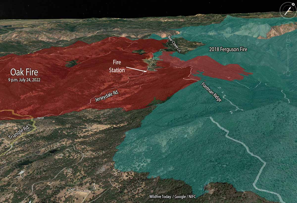
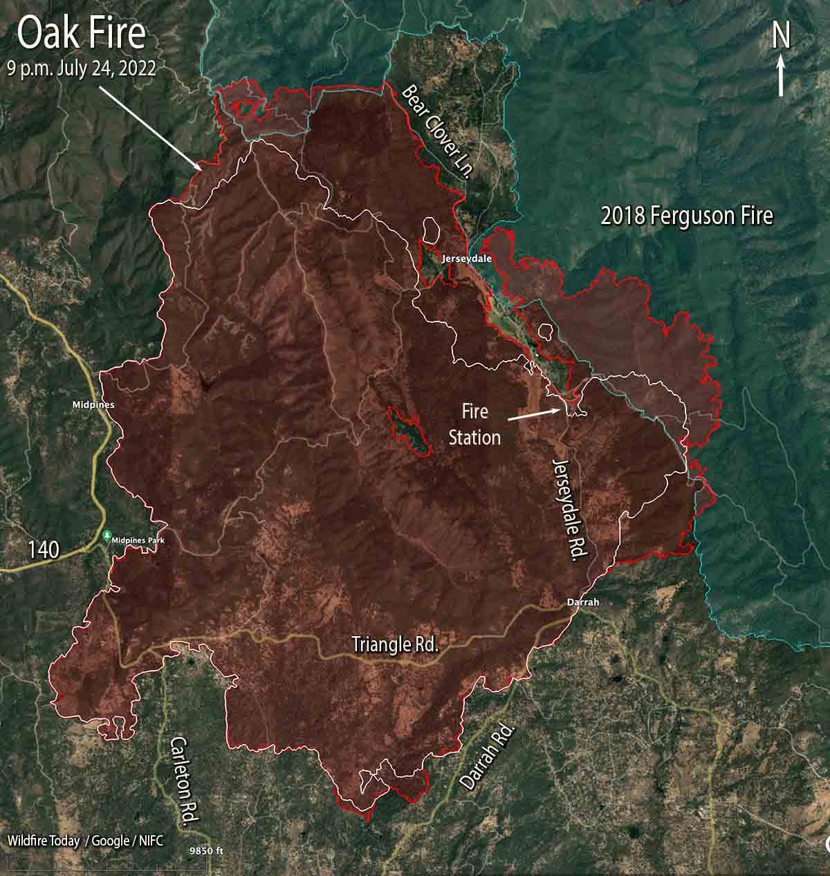
The Oak Fire northeast of Mariposa, California was very active Sunday especially on the east side where firefighters worked to minimize the spread beyond Footman Ridge and battled, successfully, to keep it from crossing Bear Clover Lane.
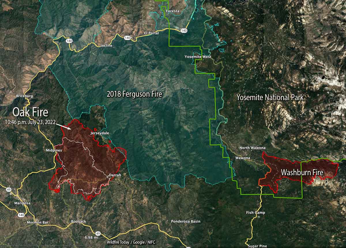
The blaze was mapped Sunday night at 16,791 acres.
To see all articles on Wildfire Today about the Oak Fire, including the most recent, click HERE.
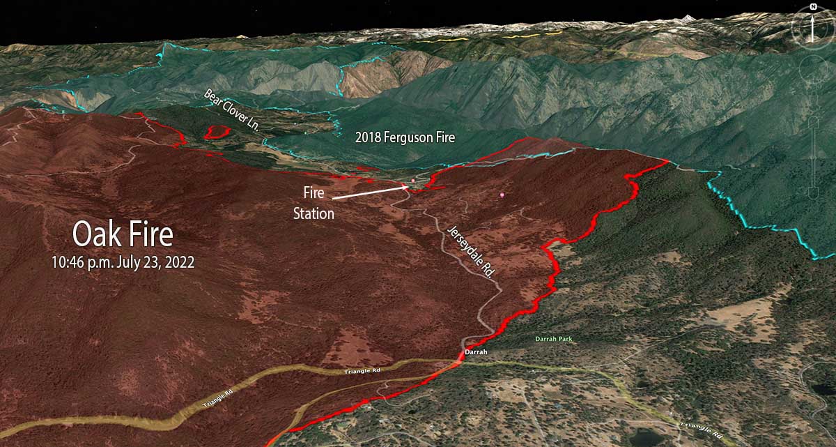
Part of the western edge of the Ferguson Fire that burned 96,000 acres in 2018 was south of Jerseydale and east of Jerseydale Road. That four-year-old footprint is not stopping the Oak Fire, but the rate of spread and intensity is greatly diminished as it burns, giving firefighters more options to put in direct fireline on the edge where they can, and construct indirect lines out ahead. Drops from helicopters and air tankers are also more effective in the lighter fuels.
While personnel have their hands full slowing or stopping the spread on the east and north sides, the south and west perimeters are looking much better. Direct fire line has been completed in many areas and tactical burning has helped to secure the edge.
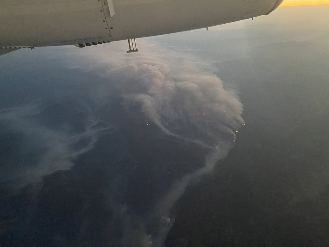
In a community meeting Sunday evening fire officials said that soon after the fire started at 2:10 p.m. Friday it was creating spot fires two miles ahead of the main fire. At that time there was little the limited number of firefighters at the scene could do other than protect lives and structures and help with evacuations.
The number of structures reported as having been destroyed remains at 10, but that number will change after the two-person damage assessment team begins to report their findings, which may be released today.
Resources on the incident include 17 helicopters, 225 fire engines, 58 dozers, 23 water tenders, and 51 hand crews for a total of 2,093 personnel.

The video below has excellent footage of air tankers dropping retardant on the Oak Fire. You’ll see in order, DC-10 with a lead plane, BAe-146, DC-10 making a downhill drop, and finally an S-2T.
#Oakfire Some of the air show on the Oak Fire on the South Eastern side pic.twitter.com/HuF5Fk7PL8
— Tim Walton (@Photo1Prod) July 25, 2022
7:54 a.m. PDT July 24, 2022
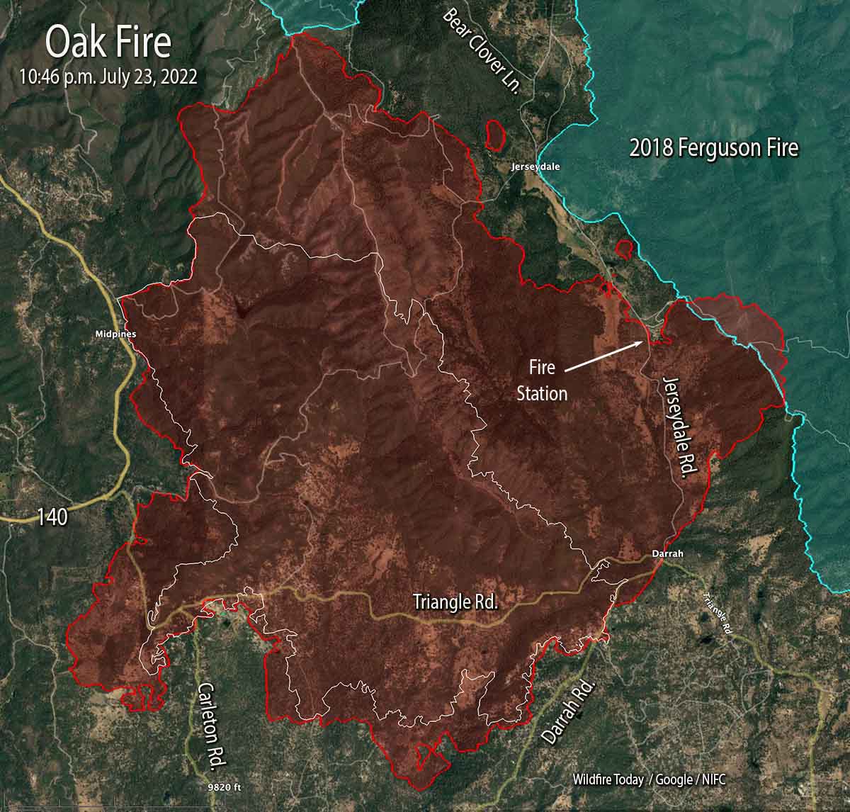
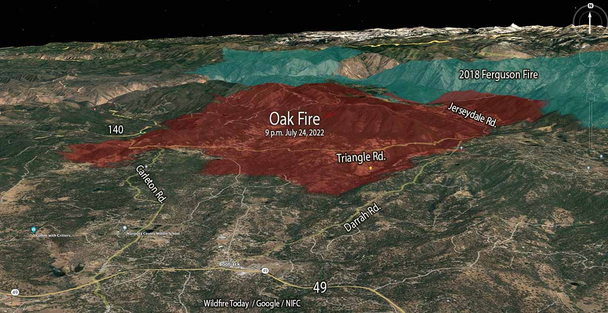
The Oak Fire two miles northeast of Mariposa, California was active on all sides Saturday and into the night. Most of the overnight movement was on the east side which saw the largest growth, spreading for one to two miles east and northeast, crossing Jerseydale road and surrounding a fire station on the road. It moved into the footprint of the Ferguson Fire which burned more than 96,000 acres four years ago.
When the fire was mapped at 10:46 p.m. Saturday night it was spreading toward Bear Clover Lane north of Jerseydale. It was six miles from Yosemite National Park, with the burn scar from the Ferguson Fire in between.
As you can see in the photo below, at 8 a.m. Sunday it was already creating a large plume of smoke.
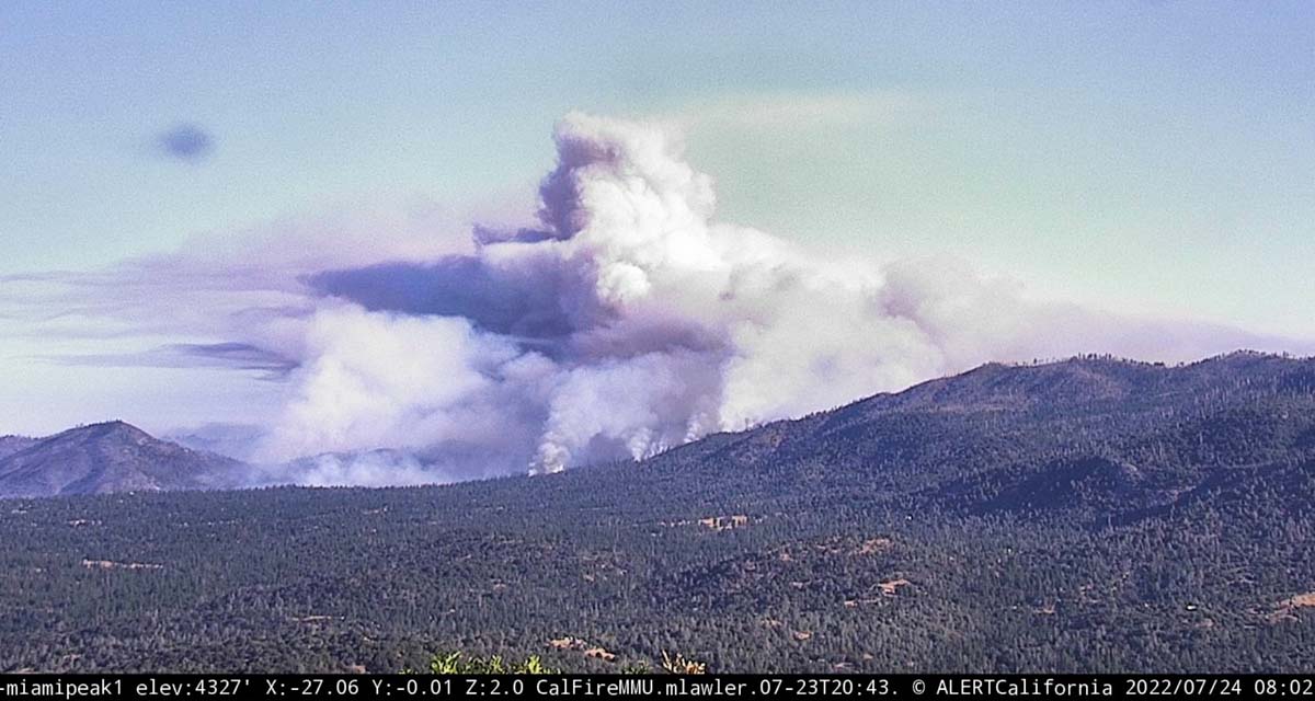
CAL FIRE reported Sunday morning at 7 a.m. it had burned 14,281 acres since it started Friday afternoon. The number of structures destroyed remained at 10.
On the south, it crossed Triangle Road then reached and crossed in some places Darrah Road.
“The fire is moving quickly. This fire was throwing embers out in front of itself for up to 2 miles yesterday,” Daniel Patterson, a spokesman for the Sierra National Forest said Saturday. “These are exceptional fire conditions.”
As of the Saturday night mapping flight the west side has remained east of Highway 140 in the Midpines area.
Evacuations are in effect. Mariposa County maintains a map online showing the affected areas.
Resources assigned include 17 helicopters, 225 fire engines, 58 dozers, 23 water tenders, and 51 hand crews for a total of 2,093 personnel.

Thanks again to O.C. and W.F.T for great reporting. Castle, I worked with others on this project 20 years ago. As stated, local government wasn’t receptive. Jerseydale was the Sierra N.F. helitack base in the early ’60s, moved to Fence Meadows, then to Trimmer. O.C. wasn’t there a fire in Mid Pines in the early 60’s that overran a F.S. engine (tank truck) resulting in three fatalities, and one critically burned?
It doesn’t look good from our vantage point about 50 miles from the fire – big header and growing. If the fire runs into the Ferguson burn scar it’s going to slop down into the Devil’s Gulch which only has two points of entrance. One is near the little hamlet of Briceberg on the Hite’s Cove Road – this is the area where last year a family died of heat stroke barely a mile into the area while hiking. The other is an old jeep trail running from Jerseydale. This is the trail that Bradden Varney HFEO on Cal Fire Dozer 4242, was trying to make access into the Ferguson when he rolled and was killed. The entire area is a very hot, steep, rattlesnake infested hell hole. Being it burned over that means light, flashy fuels. the Devil’s Gulch area is also notorious for lots of wind shifts making it even more dangerous. If the fire runs into Darrah Road and Bootjack, it’s a case again of urban/wildland interface with lots of houses, lots of narrow roads many of which are canopied over, and with no good options. I did see last evening that Tanker 911, a DC-10 out of Colorado came in, made a drop just before the cut-off and headed for McClellan.
Why not castle
Castle would be a great location for a tanker base. And, it has a runway capable of handling VLATs. The only problem is that local government does not want a permanent base there. They have allowed a portable loading facility a couple of times, but turn their collective nose up to anything else. As to why I have no idea. I know they have been approached on this subject more than once .
Actually, Cap – to clarify and to be a little more specific, the family (the Gerrish/Chungs along with their infant daughter and dog) expired on the Savage/Lundy trail near my home; one of their many owned homes in the area – and the primary one in which they lived was (again) very near my own. They had descended via the old Hites Cove Trail and after hiking the south side of the Merced River’s South Fork, they had then tried to ascend back to their car at the closed forest service gate via Savage/Lundy. That’s accessed via Hites Cove Road – and Braden Varney rolled his dozer in the early hours of Ferguson at Marble Point, which the Gerrish/Chungs would have passed three years later on the first leg of their hike.
That morning, early – while Ferguson had barely begun the previous late afternoon, my wife and I smelled smoke, so I drove up the Hites Cove (gravel) road and saw Braden’s flatbed, with the dozer gone – parked opposite the helipad. I thought, “Great – already on it, with an early start to this fire.” Went further to the gate, took some more pics with my phone of the smoke – and returned all the way home, passing Braden’s truck on the way – and shot pics of that, too.
A few hours afterwards, I then heard about Braden’s rolling, and of the hunt for him in the early hours – via chopper. I may have been the first to have seen that truck since he left it.
The other side – the northern portion of that trail on the NORTH side of the South Fork – which is known as a premier wildflower walk – begins just off 140 at Savage’s – a good six miles from Briceburg. That trailhead is actually considered to be in El Portal, not Briceburg – on the “other” side of the Ferguson outcropping and the Ferguson Slide. Right near Cedar Lodge. Across the river from the “second” incline of the old YVRR.
And FWIW, in her 1929 interview with Mrs. H. J. Taylor, Chief Tenaya’s elderly granddaughter Maria Lebrado hinted that her grandfather’s bones had been hidden down there, in the area of Hites Cove. That interview was part of Taylor’s 1932 book “The Last Survivor” and Lebrado was called such as she was the last living survivor of Major Savage’s expulsion of the Ahwahneechee during his invasion of Yosemite Valley in 1854. She didn’t return to the valley until 1929 – not long before her 1931 death.
Thanks for the update, Bill.
Unfortunately, our property is directly, imminently in the path of this one. We’re in that small then-peninsula, now-island of saved space at the northeast corner of Oak’s path in Jerseydale. And with all the wind, temperature, etc mapping and prognostication, it appears the fire will overrun our property, our 50-year-old cedar log home – before it’s hopefully stopped by the cradle of the Ferguson burn area.
We were evacuated with little warning Friday afternoon; after the initial start/reporting of this fire around 2/pm on that day seemingly FAR from us – way down THERE in Midpines – to the time the last item was thrown into the car and we headed down Jerseydale, a bright red angry tornado of smoke and fire ahead of us: was less than four hours. This one REALLY blew up and is everything it’s been described as – and more.
So – today is the make or break day for the Marsden family. We hope the fire crews who are currently, courageously striving to protect our homes – remain safe and do not in any way place our property above their safety. There’s only one road in or out, and the base of that road has already been reported as “compromised.” But I hope they know the backwoods exit plans – and know them well.
Thanks for your coverage, Bill – and here’s an affected human face to go along with it.
My concern and my sympathy to you and your family.
Thank you, Lynn – so far, so far…