Legion Lake Fire east of Custer, SD slowed Monday night

The fire has burned over 2,500 acres in Custer State Park

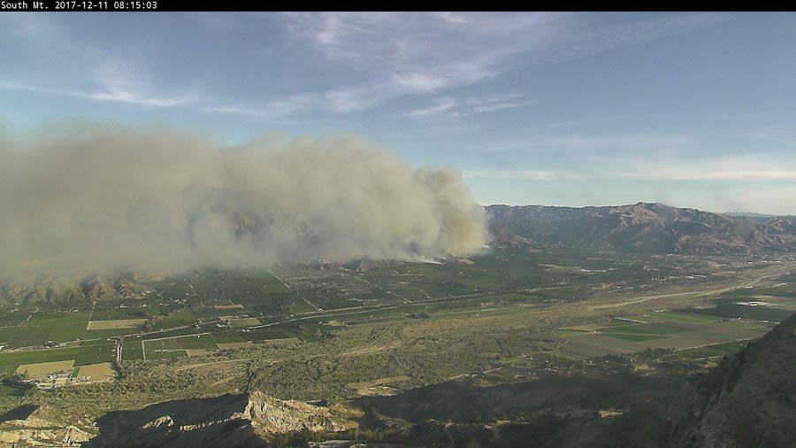
Above: The Legion Lake Fire, looking south at 1:16 p.m. MST December 11, 2017. 

(UPDATED at 7:17 a.m. MST December 12, 2017)

The spread of the Legion Lake Fire 6 miles east of Custer, South Dakota slowed overnight as the strong winds from Monday decreased. The fire has forced the closure of the park and the evacuation of the Blue Bell Lodge on Highway 87.

It started near the Lodge off Highway 16A just before 8 a.m. Monday and was pushed southeast by winds gusting up to 53 mph. By 4 p.m. the wind had decreased to 4 mph and remained between 1 and 8 mph through the night. The suspected cause is a power line hit by a falling tree near the Lodge.

Articles on Wildfire Today about the Legion Lake Fire are tagged “Legion Lake Fire”.

Monday afternoon fire personnel said it had burned 2,500 acres. Our very unofficial estimate based on satellite data is that by 3:06 a.m. Tuesday the fire had covered between 2,500 and 3,000 acres .

The wind Tuesday will be a little stronger than was predicted Monday, and should be out of the northwest at 9 to 13 mph. The relative humidity will hover around 20 percent by the afternoon and the temperature should be in the high 50’s under mostly sunny skies.

Tuesday night and Wednesday firefighters will be challenged by strong winds again — 17 to 24 mph out of the northwest gusting over 30 mph.

Two large air tankers and a lead plane will be available at Rapid City beginning at 8 a.m. Tuesday. A helicopter has also been ordered. No aircraft were used on the fire Tuesday other than a quick orbit or two by the lead plane as it arrived late in the afternoon.
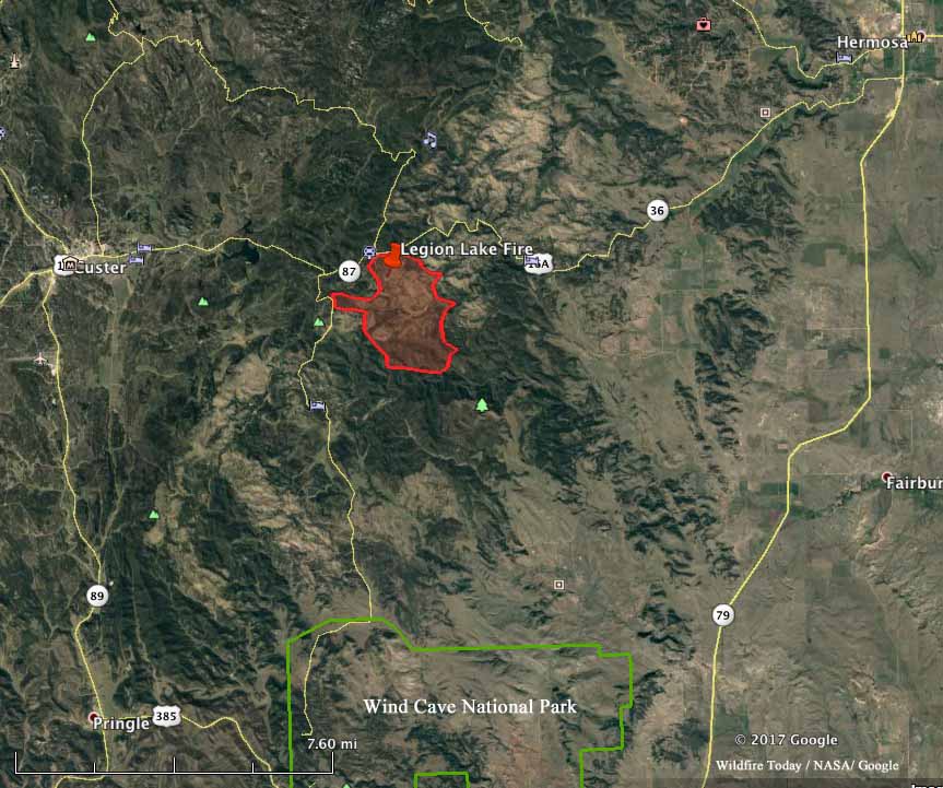
Legion Lake Fire fire south dakota
Map showing the approximate perimeter of the Legion Lake Fire in Custer State Park in South Dakota at 3:06 a.m. MST December 12, 2017.

The fire is burning south of the Legion Lake Lodge on both sides of Badger Clark Memorial Road. It is east of Highway 87, and has reached Heddy Draw.

****

(UPDATED at 5:27 p.m. MST December 11, 2017)

The Legion Lake Fire in Custer State Park in the Black Hills grew to 2,500 acres Monday afternoon, said Scott Jacobson, a spokesperson for the Black Hills National Forest. A Type 3 Incident Management Team with Incident Commander Rob Powell is on scene and Jay Esperance’s Type 2 IMT has been ordered. The fire is south of Highway 16A about halfway between Custer and Hermosa.

Two large air tankers (including Tanker 101, an MD-87), an Air Attack aircraft, and a lead plane should have arrived at Rapid City late Monday afternoon. T-101 was at there by about 3:30 but was waiting for a lead plane to work with him. The Incident Commander said that at that moment there was no assignment for the air tanker and the second one that was en route, and do not load them with retardant. They were told to be available for missions at 8 a.m. Tuesday. A helicopter is also on order. Four 20-person Type 2 hand crews were ordered Monday morning.

Typically this time of the year no firefighting aircraft are on duty in South Dakota, and it can be difficult to find them anywhere in the country. But quite a few were rounded up last week for the wildfires in Southern California.

At 4:50 p.m. Mr. Jacobson said 30 engines and a total of 200 personnel were assigned to the fire.

The strong winds that caused the fire to spread so quickly on Monday will decrease overnight and will be from the west or northwest at about 6 to 8 mph Monday night and Tuesday. The relative humidity Tuesday will be about 20 percent and the temperature will reach 56 degrees. Tuesday night and Wednesday will be quite windy, 15 mph out of the northwest with gusts at 25 to 28 mph. In light of that forecast, firefighters should be able to make good progress on Tuesday before the winds hit again the next day.
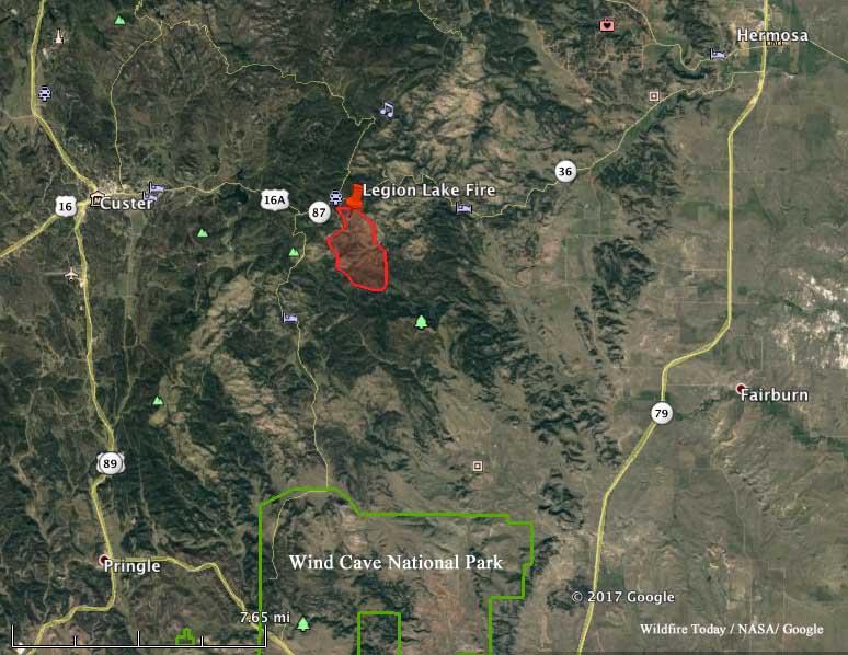
map legion lake fire south dakota
Map showing the approximate perimeter of the Legion Lake Fire in Custer State Park in South Dakota at 1:07 p.m. MST December 11, 2017.

****

(Updated at 1:23 p.m. MST December 11, 2017)

The Legion Lake Fire was reported near the Legion Lake Lodge in Custer State Park in the Black Hills of South Dakota just before 8 a.m. MST on December 11, 2017. By 10: 20 a.m. it had burned an estimated 1,000 acres about 6 air miles east of Custer. A Type 3 Incident Management Team has been ordered. Portions of highway 16A and 87 are closed.

There has been very little precipitation in the Black Hills during the last month or so. At 9:18 a.m. MST today a weather station a few miles southeast of the fire recorded 45 degrees, 20 percent relative humidity, and winds out of the north at 22 mph gusting to 45.
Smoke from Thomas Fire affects air quality in California

Above: Wildfire smoke forecast for 6 p.m. PST December 10, 2017.

(Originally published at 3:30 p.m. PST December 10, 2017)

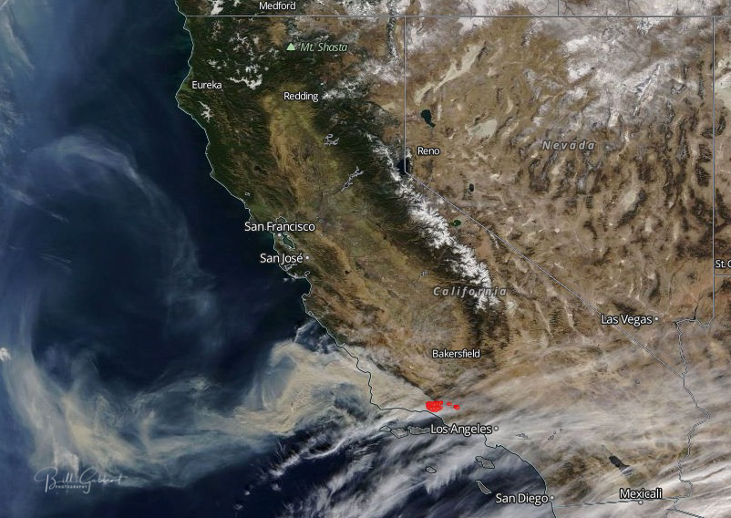
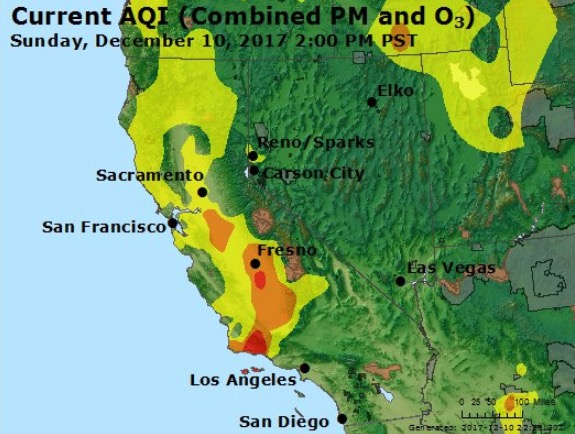
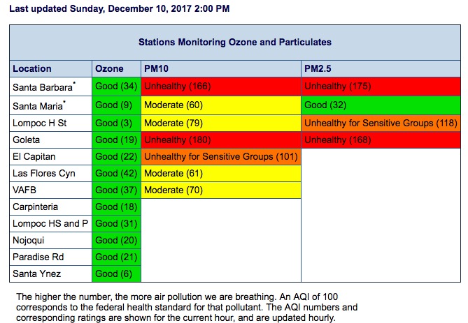
The Thomas Fire is having a significant effect on the air quality in California. Some areas downwind of the fire to the northwest had “unhealthy” conditions at 2 p.m. Sunday, including Santa Barbara and Goleta. Forecasts show that smoke and ash will continue to affect the southern part of Santa Barbara County for the next several days. The Santa Ynez Valley and the northern parts of the County will see increasing impacts.

Thomas Fire smoke air quality
Satellite photo showing smoke from the Thomas Fire December 10, 2017.
Thomas Fire smoke air quality
Air quality at 2 p.m. PST December 10.
Thomas Fire smoke air quality
Air Quality in Santa Barbara County at 2 p.m. PST December 12, 2017.

Red Flag Warnings continue in Southern California

Red Flag Warnings have been issued for areas in Southern California, Colorado, South Dakota, Nebraska, and Kansas.

In Los Angeles and Ventura Counties east winds of 20 to 30 mph with gusts up to 45 mph will continue at times today (Sunday) and again late tonight and Monday, however, winds are expected to be weaker on Monday. Meanwhile, minimum humidities of 3 to 10 percent will be common through at least the middle of next week, with widespread poor overnight recoveries mostly staying under 30 percent. As a result, critical Red Flag conditions will persist over most of Los Angeles and Ventura Counties through Sunday with a chance for locally critical conditions continuing into Monday especially in the mountains. The Santa Barbara County Mountains will also remain in critical fire weather conditions today due to plume development of the existing fire and very low humidity.

The map was current as of 10:39 a.m. MST on Sunday. Red Flag Warnings can change throughout the day as the National Weather Service offices around the country update and revise their forecasts.

Thomas Fire spreads into Santa Barbara County

New mandatory evacuation orders issued. New estimates show approximately 230,000 acres have burned.

Above: The Thomas Fire as seen from Sisar Peak east of Ojai at 9:07 a.m. PST December 10, 2017.

(UPDATED at 9:58 p.m. PST December 10, 2017)

The Thomas Fire has spread well into Santa Barbara County, and Sunday afternoon was on the slopes north of Carpinteria, California. The strong northeast Santa Ana wind slowed, as has the fire growth, but the vegetation is so dry that a moderate wind can still keep it moving at a persistent pace

(All articles on Wildfire Today about the Thomas Fire are tagged “Thomas Fire”.)

Sunday evening the U.S. Forest Service reported the fire has burned 230,000 acres. If this is accurate it puts it at number 5, near the top of the list of the largest fires in the recorded history of California.

top 20 largest fires in California

The forecast calls for wind on the slopes above Carpinteria Sunday night to be from the northeast at 10 mph, variable directions on Monday, and then Monday night to again be from the northeast but stronger, 15 mph with gusts to 23. The relative humidity will remain in the teens night and day through Tuesday. This could lead to active fire behavior throughout that period.

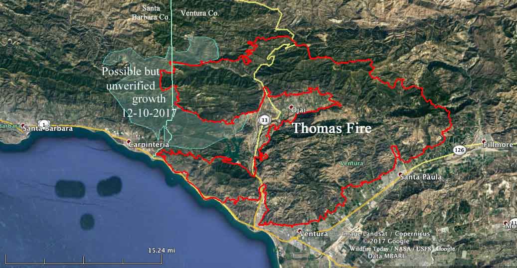
Using heat sensor data from a satellite, we mapped the additional acres that burned on the west side of the fire Saturday night and early Sunday morning. It is shown in blue on the map below, and this freshly burned area covers about 40,000 acres. The data is not verified, since at times the heat sensor was overwhelmed by hot particulate matter in the smoke plume outside the actual fire perimeter, so this may change after more accurate information is available from an overnight fixed wing aircraft mapping flight.

map Thomas fire Carpinteria california
Draft map showing an approximation of the additional acres (in blue) that burned in the Thomas Fire Saturday night and Sunday morning. This is preliminary and subject to change. Click to enlarge.

****

(UPDATED at 4:55 p.m. PST December 12, 2017)

At a town hall meeting about the Thomas Fire at San Marcos High School today, officials provided updated information.

The fire made a major run during much of the day on Sunday, adding an estimated 50,000 acres which could bring the total size up to around 225,000 acres by the end of the day. This would make it the 5th largest in recorded history of the state. These numbers are subject to verification by aerial mapping scheduled for Sunday night.

Town Hall meeting Thomas Fire
Town Hall meeting about Thomas Fire, 4 p.m. December 12.

An additional 100 fire engines were ordered for the Santa Barbara area.

The live broadcast was hosted by VCFD_PIO on Periscope.

By the numbers:

Structures Threatened: 15,000
Structures Destroyed: 754
Structures Damaged: 162
Engines: 611
Water Tenders: 31
Helicopters: 30
Hand Crews: 55
Dozers: 51
Total Personnel: 4435

****

(Updated at 9:51 a.m. PST December 10, 2017)

New evacuation orders have been issued for areas in Santa Barbara County as the Thomas Fire aggressively spreads further west. Saturday afternoon it moved into the county north of Carpinteria putting up massive convection columns of smoke Saturday night and Sunday morning as strong winds and very low humidity persisted throughout the night.

The fire continues to burn actively to the north, east, and west threatening structures in parts of the cities of Ventura, Ojai, Casitas Springs, Santa Paula, Carpinteria, Fillmore and the unincorporated areas of Ventura County and Matilija Canyon. It is expected to spread towards Sespe Wilderness and the Sespe Condor Sanctuary.

CAL FIRE reported Sunday morning that the Thomas Fire has burned 173,000 acres and destroyed 537 structures, damaging 118 others.

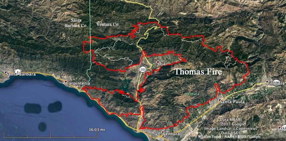
thomas fire map december 10 2017
Map of the Thomas Fire. The red line was the perimeter at 9:30 p.m. PST December 9, 2017. The white line was the perimeter 24 hours before.

The latest information about evacuations is at the Santa Barbara County website, but generally, as of 7 a.m. Sunday, the new area is “north of Highway 192, E. Valley Road, east of Buena Vista Drive, to include the 900 block of Park Lane, is a mandatory evacuation zone. Everything south of Highway 192, E. Valley Road, east of San Ysidro, is under a voluntary warning order.” (map) An evacuation shelter has been established at the UCSB Recreational Center, 516 Ocean Road, Santa Barbara.

The weather continues to be a challenge for firefighters. The Sunday forecast call for a Red Flag Warning including winds northeast at 20 to 30 mph with gusts up to 45 mph. And on Monday, 15 to 20 mph with gusts to 35 mph.

Firefighters Thomas Fire
Firefighters on the Thomas Fire at 4 a.m. PST December 10, 2017. Photo by Santa Barbara County Fire Department.

Red Flag Warnings in Southern California and Colorado

Red Flag Warnings have been issued for areas in Southern California and Colorado.

An extended period of Santa Ana offshore winds will continue through at least Sunday focused over much of Los Angeles and Ventura Counties. The winds today will be the weakest of the next three days with gusts generally in the 30 to 40 mph range, and more afternoon onshore flow nearer to the coast. The winds should increase Saturday and peak on Sunday with gusts in the 40 to 50 mph range (but still much weaker than Thursday). Meanwhile, minimum humidities of 5 to 10 percent will be common through at least the middle of next week, with widespread poor overnight recoveries mostly staying under 30 percent. As a result, critical Red Flag conditions will persist over most of Los Angeles and Ventura Counties through Sunday.

The map was current as of 11:45 a.m. MST on Friday. Red Flag Warnings can change throughout the day as the National Weather Service offices around the country update and revise their forecasts.