200-acre Emerald Fire at Lake Tahoe slowed by rain

map Emerald Fire
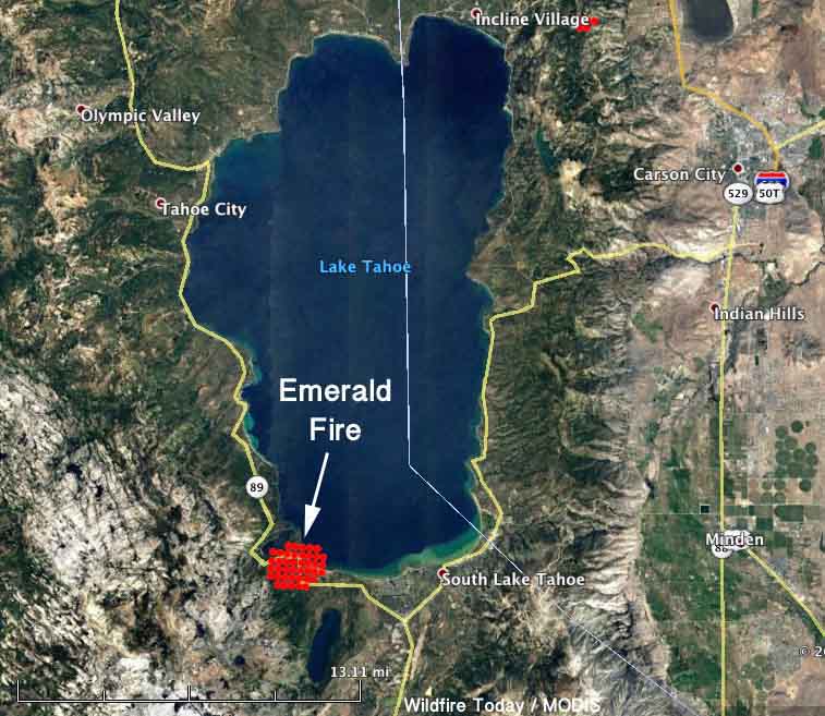
Map showing heat detected by a satellite over the Emerald Fire at 2:16 a.m. PDT October 14, 2016. The fire is much smaller than indicated by the heat signatures, some of which were plotted in Cascade Lake and up to half a mile out into Lake Tahoe by the 375-meter fire detection system on the MODIS satellite.

The Emerald Fire was reported at 1:28 a.m. PDT October 14 on the south end of Lake Tahoe in California near Emerald Bay. Pushed by 20 to 25 mph winds gusting up to 55 mph it quickly spread through the night and by daylight was estimated at 200 acres by CAL FIRE. Mandatory evacuations were ordered affecting 500 residences and another 500 were listed as voluntary.

However by 6 a.m. on Friday light rain began as a wet air mass moved into the area. As of 11 a.m. a quarter inch of precipitation had been measured at the South Lake Tahoe weather station.

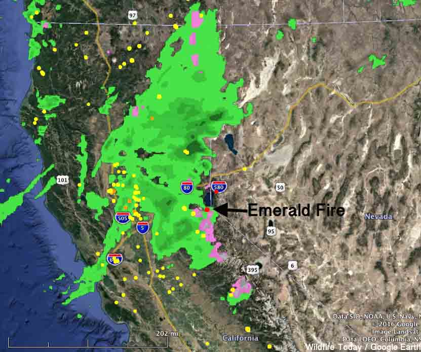
emerald fire rain radar
The green areas represent rain in northern California at 11:04 a.m. PDT October 14, 2016.

The weather forecast for the area of the Emerald Fire includes 1.8 inches of precipitation over the next 48 hours.

Web cams for the area can be seen at Alerttahoe.seismo.unr.edu. Click on the Diamond Peak and Heavenly Ski Area cams.

Emerald Fire
Web cam view of the area of the Emerald Fire at 11:12 a.m. PDT October 14, 2016. The fire should be on the left side of the photo.

Red Flag Warnings, October 14, 2016

The National Weather Service has posted Red Flag Warnings or Fire Weather Watches for areas in California, Nevada, Wyoming, Nebraska, South Dakota, and Colorado. The Warnings end Friday evening, while the Watch in Colorado expires Saturday at 7 p.m. MDT.

The Red Flag map was current as of 9:30 a.m. MDT on Friday. Red Flag Warnings can change throughout the day as the National Weather Service offices around the country update and revise their forecasts and maps.

The graphic below was issued by the NWS office in Rapid City, South Dakota. This forecast for Friday covers western South Dakota and portions of North Dakota, Montana, Wyoming, and Nebraska.

fire weather black hills

Two firefighter injuries, a snakebite and gasoline fire

Reports about two notable injuries to wildland firefighters have been released in recent days.

A “72-hour” report provides very little information about another in a series of accidents that may involve a “gasoline geyser”. The document does not include the date of the injury, the location of the accident, or the name of the fire or incident, but it was issued by the Arapaho and Roosevelt National Forest and Pawnee National Grassland headquartered in Fort Collins, Colorado. It is titled “Pingree Hill Chainsaw Incident” and says a firefighter that was working on a prescribed fire sustained gasoline fire burns to the abdomen, arm, and wrist related to a chainsaw while working on a prescribed fire. He was flown to the Northern Colorado Burn Center where he is recovering.

Since at least September 30, 2016 Inciweb has had information about a 2,027-acre “Pingree Hill Prescribed Fire” near Rustic, Colorado that apparently is being conducted on an intermittent basis.

Many injuries have been reported in the last couple of years related to gasoline being forcefully released from chain saws. Some of these incidents have occurred with saws that have the new quarter-turn gas caps.

Here is a video released a year ago on the subject:

The second injury is titled “Rattlesnake Bite” in the Rapid Lesson Sharing report that was released by the Wildland Fire Lessons Learned Center. It happened on the Kent Fire in Montana July 24, 2016. The firefighter never saw or heard the snake that bit him, the report says.

Below are excerpts from the report:

A team of more than five EMTs were assigned to patient care, with one EMT identified as lead caregiver.

[…]

Disagreement Involving Interventions and Patient Care

Once the ambulance arrived on scene, there was a disagreement between the ambulance personnel and onsite EMTs involving interventions and patient care being provided. Because of the dispute and increased level of pain experienced by the patient, Division Whiskey decided to transport the patient via the DNRC [Montana Department of Natural Resources and Conservation] helicopter.

The lead caregiver and one other DNRC EMT joined the patient in transit to Baker. The DNRC Task Force Leader followed via ground transport in order to bring the EMTs back once patient care had been transferred.

Upon arrival at the Baker Municipal Airport, the patient was transported to the Fallon Medical Complex emergency room. Medical personnel assessed the bite and cleaned wound.

Because it was determined that side-effects could have adverse effects on this patient, it was decided to hold off on administering antivenin, a biological product used in the treatment of venomous bites and stings. After tissue samples were taken and sent to the lab, it was determined that the bite was nonvenomous.

The patient was monitored and released that evening.

Red Flag Warnings, October 13, 2016

The National Weather Service has posted Red Flag Warnings or Fire Weather Watches for areas in California, Nevada, Arizona, Wyoming, Nebraska, South Dakota, and Colorado. For most of the locations the conditions will persist into Friday.

The Red Flag map was current as of 9:50 a.m. MDT on Thursday. Red Flag Warnings can change throughout the day as the National Weather Service offices around the country update and revise their forecasts and maps.

wildfire red flag warnings
Red Flag Warnings (red) and Fire Weather Watches (yellow) for October 13, 2016.

Smokejumpers on a 1-acre fire get chased by another fire

“We do not have a safety zone, and our escape route is threatened.”

Above: File photo. Smokejumpers at Missoula board a Twin Otter, August 11, 2012. Photo by Bill Gabbert.

I didn’t know the Bleacher Report covered anything other than sports, but earlier this week they published a lengthy article about smokejumpers unfortunately titled, “Superheroes Are Real”. It is mostly well written by Rachel Monroe and explores rookie training, firefighting, and aspects of waiting at an airport for a fire dispatch.

Much of the story is told from the viewpoint of Erik Vermaas, who had at least one memorable quote:

[Hotshots] walk in single file in fire camp,” says Vermaas, the second-year jumper. “You can just tell smokejumpers are different. They’re not a number. These dudes roll through fire camp and it’s like, Who the f*** is that? You can tell.

Part of the article describes how “last summer” three of them jumped on a fire in the Selway-Bitterroot Wilderness, near the Idaho-Washington-Oregon border and by the fourth day had the one-acre blaze pretty much wrapped up.  The excerpt below picks up on that fourth day:

****

“…At nine that morning, a pilot flying overhead radioed the crew: You guys know you’ve got a fire-start right next to you? One of the other jumpers volunteered to bushwhack up the ridge to check out what was going on. It was slow going; the jumpers had been working in the thick, 20-foot-high brush that made walking a quarter-mile feel more like walking four. When the scout made it to the top of the ridge, he immediately radioed back: Let’s get out of here.

The fire had crowned—that is, started burning in the tops of the trees. The wind was pushing it toward the jumpers, and it was moving fast. In other circumstances, maybe the jumpers would have radioed for a plane to dump a tanker of retardant on the flames to slow things down, but by around 11 a.m., all those little fires had merged into a big one, and the smoke was so thick the helicopters couldn’t see a damn thing. Vermaas and the other jumper waited anxiously for the scout to fight through the brush back to them. The other jumper with Vermaas, a guy with decades of experience, barked into the radio: We do not have a safety zone, and our escape route is threatened. “That means,” Vermaas explains, “you basically are running out of options.”

Vermaas heard the loud, gunning sound of what he thought was a helicopter; he watched the treetops sway and felt a momentary surge of relief—until he realized that it wasn’t a chopper making that sound, or all that whooshing wind. The danger was the fire itself, ripping its way through the treetops toward them. No plane or rescue vehicle could make it anywhere near them; they’d have to get themselves out of this mess, and fast.

By the time the third crew member showed up, Vermaas says, “it was already f****** go time.” The jumpers ditched their gear—“We made the decision, ‘F*** the gear, f*** everything, leave it, we’re going’”—and made their way through the brush, racing the fire down toward the river. Vermaas tried not to think about what would happen if the fire spotted and caught below them—fire burns fastest uphill, and when it gets going even the most fleet-footed smokejumper doesn’t stand a chance. All three jumpers made it down to a creek and safe haven, but it was close.

Vermaas stood in the creekbed, then watched as the trees swayed with the energy only a fire could create—when wildfires burn hot enough, they can generate their own weather. Half an hour or so more and those flames would’ve burned right over them. Days later, a salvage crew went in to look for the jumpers’ gear. The only remnants they found were metal grills from their jump helmets and six fasteners from their parachutes. Everything else had been reduced to ashes…”

****
Thanks and a tip of the hat go out to Paul.
Helping a family deal with a line of duty firefighter fatality

This is a wonderful story about how after the 2004 line of duty death of a wildland firefighter, the family was immeasurably helped by the firefighter’s crew, the agency, and the Wildland Firefighter Foundation (who produced this video in 2016). And it continued for more than a decade.