One year in: reflections on the wildland fire science journal

By Martin Girardin

In his editorial in International Journal of Wildland Fire, Co-Editor-in-Chief Martin Girardin shares some of the challenges facing the journal, celebrates the achievements and offers thoughts on where he believes both the field of wildland fire science and this publication are heading. And there is global call for new Associate Editors in new fields of wildfire science.

It has now been a year since I stepped into the role of co-Editor-in-Chief of the International Journal of Wildland Fire (IJWF). As summer sets in and the day-to-day demands of my government position ease, I find myself with a moment to reflect on this transformative experience.

Journal context and legacy

The IJWF stands as a cornerstone of wildland fire research – a not-for-profit society scientific journal covering all aspects of wildland fire science and management. Published under the stewardship of the International Association of Wildland Fire (IAWF), a non-profit organisation dedicated to facilitating communication and providing leadership for the wildland fire community worldwide, the journal has served as the premier venue for fire science discourse for over three decades.

Since its founding in 1992, IJWF has continuously grown and evolved under the distinguished guidance of three exceptional Editors-in-Chief. Mike Flannigan, my former PhD co-advisor, served throughout 2002–2008, establishing the journals reputation for rigorous peer review and broad scientific scope. He was succeeded by Stefan Doerr and Sue Conard, who served as co-Editors-in-Chief and worked together to strengthen the journals international reach and interdisciplinary approach, providing remarkable stability and growth to the publication. Most recently, Sue continued in the role from 2009 until her well-deserved retirement in the summer of 2024, at which point I was nominated to succeed her as co-Editor-in-Chief.

My connection to IJWF extends well beyond this past year. Having served as an Associate Editor since 2006, I was already deeply familiar with the journals culture, standards and the dedicated community of researchers, practitioners and stakeholders who contribute to its success. This long-standing involvement provided invaluable preparation for the transition to the Editor-in-Chief role, though nothing could have fully prepared me for the breadth and complexity of the challenges ahead.

A year in numbers: growing impact and reach

Taking over an Editor-in-Chief role inevitably comes with its challenges, and the past 12 months have been both demanding and deeply rewarding. Over this period, IJWF has received 216 submissions from 33 countries, a testament to both the international scope of our readership and the increasingly global nature of wildland fire science. We published 119 articles last year, each representing months of dedicated work by our authors and the rigorous review process maintained by our Associate Editors, editorial board members and peer reviewers.

The numbers alone tell a compelling story of growth and engagement. Over the last six months, we have observed a notable acceleration in manuscript submissions, reflecting the mounting global attention on fire-prone ecosystems in the context of climate change. The expansion in research activity we observe at IJWF mirrors broader trends in the field. Contemporary submissions span traditional fire ecology and behaviour studies, cutting-edge modeling innovations, community resilience and social impact assessments, fire management strategies and emerging interdisciplinary research that bridges natural and social sciences.

Climate change has thrust wildland fire into the global spotlight, transforming it from a specialised area of study into a critical component of environmental science, public policy and societal resilience planning. As wildfire activity intensifies across many regions worldwide – from the Mediterranean basin to the boreal forests of Canada, from the chaparral of California to the eucalyptus forests of Australia – research efforts have expanded dramatically. The breadth of topics reflects not only the maturation of fire science as a discipline but also the urgent need for comprehensive, evidence-based solutions to increasingly complex fire management challenges. This transformation brings both opportunities and responsibilities for our journal and the broader fire science community.

Navigating editorial challenges in a rapidly evolving field

While this growth is encouraging, it has also presented us with a complex set of challenges that require thoughtful adaptation and strategic planning.

Our editorial team is composed of experienced Associate Editors, many of whom are senior researchers and generalists with deep disciplinary knowledge across the breadth of fire science. This foundation has served us exceptionally well over the years, providing the expertise needed to evaluate diverse submissions and maintain our standards of scientific rigour. However, the pace of technical innovation in our field is accelerating at an unprecedented rate.

New modeling frameworks, artificial intelligence (AI)-driven data synthesis, advanced remote sensing techniques and sophisticated computational approaches are emerging faster than most researchers – let alone editors – can fully absorb and evaluate. Machine learning applications in fire prediction, high-resolution satellite-based fire detection systems and complex coupled climate-fire models represent just a few examples of the increasing technical sophistication of submissions. Ensuring robust peer review for such specialised topics while maintaining our commitment to accessibility and broad relevance poses a significant challenge.

In parallel, emerging research priorities increasingly reflect the complexity of fire-climate-vegetation interactions. The field is evolving beyond traditional fire weather indices to encompass compound events, long-term system thresholds and diverse knowledge systems. This includes critical advances in understanding fire-drought synergies, paleo-informed reconstructions of reference conditions and climate attribution of extremes – as well as a growing recognition of Indigenous fire stewardship and traditional ecological knowledge.

While there is strong confidence that fire weather will intensify with ongoing climate change, the direction and magnitude of vegetation responses – especially under various management interventions – remain far more uncertain. Understanding the impacts of silvicultural strategies such as fuel treatments, species selection and the assisted migration of genetically differentiated, drought-adapted populations is central to forecasting future fire regimes. These vegetation dynamics will ultimately shape the spatial and temporal patterns of biomass burning across near- and long-term horizons. These developments are not only expanding the scope of wildland fire science, but also challenging us to integrate across disciplines in ways that support more holistic and actionable understanding.

Renewing and diversifying editorial leadership

Compounding this challenge, several of our long-serving Associate Editors have recently concluded their terms, taking with them decades of experience and institutional knowledge. While we celebrate their many contributions to the journal and the field, this transition presents an opportunity and an imperative for renewal to further enrich our editorial board – aligning its composition with the evolving frontiers of fire science and the diversity of our global readership.

To that end, as a community journal, we’re always looking to expand the experience, breadth of scope and diversity of our editorial board. We want our editorial board to reflect the diversity of our audience, providing unique perspectives and coverage in niche topics. We encourage applications from researchers with broad methodological expertise, including early-career scientists who bring fresh perspectives, quantitative modelers with cutting-edge technical skills and interdisciplinary researchers working at the intersections of ecology, climate science, data science and social research.

This strategic renewal will support our continued ability to engage with the rapidly expanding scope of wildland fire science, while ensuring that we maintain the rigorous standards and broad accessibility that define IJWF.

One of our ongoing editorial challenges involves maintaining an appropriate balance between encouraging methodological innovation and ensuring practical applicability. While we actively welcome innovation – particularly in fire modeling, process-based ecological approaches and machine learning applications – we require that all manuscripts remain grounded in scientific rigour and demonstrate clear implications for fire management, policy development or a fundamental understanding of fire processes.

As the field matures, the need for synthesis and methodological review papers is also becoming more pronounced. These articles can consolidate knowledge across disciplines, highlight research gaps and provide much-needed guidance for future work. This balance is crucial because the real-world impact of our published research remains a core tenet of IJWF. Our readers include not only academic researchers but also fire managers, policymakers and practitioners who depend on our publications to inform critical decisions affecting communities and ecosystems worldwide.

A shared responsibility

As wildland fire science continues to evolve, I remain optimistic about the direction of both wildland fire science and IJWF. This not-for-profit society journal thrives because of its community. I am deeply grateful to our Associate Editors, editorial board members and reviewers for their expertise and generosity. Their dedication ensures that IJWF continues to publish thoroughly peer-reviewed research that advances both scientific understanding and practical fire management.

Martin P. Girardin

Co-Editor-in-Chief, IJWF

Research Scientist

Canadian Forest Service, Natural Resources Canada

Girardin Martin P. (2025) One year in: reflections from the IJWF Co-Editor-in-Chief. International Journal of Wildland Fire 34, WF25151. https://doi.org/10.1071/WF25151

Circumpolar wildland fire and permafrost thaw – Global climate implications: Wildfires in the Arctic

The Arctic refers to circumpolar tundra and boreal ecosystems; within this lies the northern permafrost region. Image by Christina Shintani, Woodwell Climate Research Center.

By Brendan Rogers and Susan Natali

Wildfires have been a natural part of Arctic ecosystems – including tundra and boreal forests – for thousands of years. As in other regions, wildfire helps to shape and maintain these ecosystems, impacting plant traits, ecosystem diversity, and composition. However, climate change is making Arctic fires more frequent, intense, and widespread. The Arctic is warming two to four times faster than the rest of the planet, leading to longer fire seasons, more extreme fire weather, and increased lightning strikes that ignite fires.

This article is from a special issue of Wildfire magazine from the International Association of Wildland Fire and the Arctic Council. In this issue scientists, policy experts, community and Indigenous leaders provide clear insights on what is occurring with wildland fire in the Arctic and how best to respond, locally, nationally and internationally.

In addition to combusting vegetation, wildfires in the Arctic also burn the organic soil layers, which play an important role in insulating and protecting the permanently frozen ground, called permafrost, that underlies the tundra and much of the boreal forest. When vegetation and soils are removed by fire, this can trigger or accelerate permafrost thaw.

Most permafrost has been frozen for hundreds to thousands of years. Over time, organic carbon derived from plants has slowly accumulated in permafrost soils because the frozen conditions slow decomposition, leading to the accumulation of an immense amount of carbon – on the order of 1,600 billion tons, or roughly three times the amount of carbon contained aboveground in all the world’s forests. With climate warming, permafrost is thawing, and microbes are decomposing this ancient carbon and releasing it into the atmosphere as greenhouse gasses, carbon dioxide and methane. The release of greenhouse gasses from permafrost thaw, referred to as the permafrost carbon feedback, could be a major accelerant of global climate change in the coming decades and centuries.

Wildfires amplify the permafrost carbon feedback. At the time of burning, Arctic wildfires release large amounts of carbon in the form of carbon dioxide, methane, and other gases and aerosols due to the combustion of organic soils. In fact, the levels of carbon emitted per unit area from Arctic wildfires are among the highest on Earth, rivaled only by tropical peatland and deforestation fires. For the most part, this carbon can ultimately be removed from the atmosphere by vegetation regrowth and stored by ecosystems over a period of decades to centuries. However, by burning the upper soil layers that otherwise keep permafrost cool, Arctic fires also initiate and exacerbate permafrost thaw. In some cases, this is barely noticeable from the surface but can still generate greenhouse gas emissions. In other cases, permafrost with high ice content can thaw abruptly, leading to dramatic features such as thermokarst lakes and permafrost thaw slumps, generating even higher levels of carbon emissions.

HOW ARE ARCTIC FIRES CHANGING?

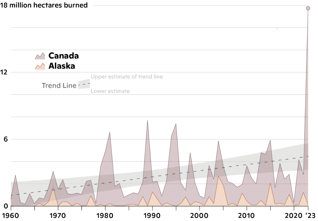
Long-term trends in area burned across Canada and Alaska, developed with data from the Canadian Wildland Fire Information System and the Alaska Interagency Coordination Center. Image by Greg Fiske, Woodwell Climate Research Center.

Many studies have documented the links between Arctic fires and climate change. The best long-term observational data come from Alaska and Canadian government databases, which detail fires and their area burned since the mid-20th century. From the databases, we know the average yearly burned area across Alaska and Canada during the past two decades is roughly twice that of pre-climate change levels. By far, the most severe fire season was 2023. Canadian wildfires in 2023 burned more than twice the area of any other year on record and emitted between 480 and 760 million tons of carbon. For perspective, that’s three to five times higher than annual emissions from all other sectors in Canada combined, and higher than every country’s annual emissions except China, the United States, and India. It should be noted that regrowing forests from these fires are unlikely to re-sequester much carbon by the mid-21st century – when the world otherwise needs to be approaching net-zero emissions to limit the most damaging impacts from climate change –and that these estimates do not include postfire permafrost emissions.

Novel fire years are not limited to Canada. Russia, for instance, experienced unprecedented wildfire activity in eastern Siberia and north of the Arctic circle in 2019, 2020, 2021 and 2024, which has been linked to warming temperatures, early snow melt, and polar jet dynamics associated with climate change. If current climate warming trends continue, Arctic fires will likely become even more frequent and intense. Studies project a 75 per cent increase in Arctic burned area for every degree Celsius of global warming.

The carbon released by these fires, combined with emissions from permafrost thaw, could rival those of major global economies. Yet these emissions are not currently accounted for in global climate models nor are they fully accounted for in the “accounting framework” used to assess progress toward the Paris Agreement goal of limiting warming to well below two degrees Celsius above pre-industrial levels.

Carbon and climate are not the only causes for concern over increasing Arctic wildfires. These fires emit smoke that degrades air quality and threatens human health for communities near and far. Wildfires impact habitat and subsistence activities for Indigenous communities, can shut down aviation and overland travel, damage infrastructure, and lead to mass evacuations.

Ground slumping in yedoma permafrost after a wildfire, in the interior of Alaska. Yedoma permafrost generally contains large amounts of ground ice, making it vulnerable to abrupt thaw after fires. Yet fires can accelerate permafrost thaw and carbon emissions in many different types of permafrost. Photo by Torre Jorgenson.

WHAT TO DO?

The situation is urgent, and solutions exist. Governments can prioritize wildfire preparedness and community protection plans, fuels treatments and fire breaks around fire-prone communities, and improve real-time forecasting and information sharing, especially with rural and Indigenous communities. Supporting cultural burning practices, where Indigenous communities conduct controlled burns to manage landscapes, can also reduce the risk of severe wildfires. Finally, the combination of improved satellite detection and emerging technology such as autonomous firefighting aircraft presents opportunities for early action suppression of the most damaging wildfires.

However, the most critical solution lies in reducing global greenhouse gas emissions. Cutting global emissions will slow Arctic warming, reducing the conditions that fuel these fires and making other wildfire prevention efforts more effective. Arctic fires are a growing global concern with wide reaching implications for the climate and communities worldwide. By investing in local adaptation, embracing Indigenous knowledge, and tackling the root cause – climate change –we can work toward a more resilient future.

Brendan Rogers is an associate scientist at the Woodwell Climate Research Center in Massachusetts. Rogers uses a combination of field measurements, satellite remote sensing, and modeling techniques to diagnose the impact of increasing Arctic fires on carbon and climate. Rogers uses science to inform natural resource management and policies for improved climate mitigation, adaptation, and ecosystem protection.

Susan Natali is a senior scientist at the Woodwell Climate Research Center whose research on permafrost thaw is motivated by an acute awareness of the risks it poses. Natali has worked extensively across the Arctic, in Alaska, Siberia, and elsewhere, combining field research of permafrost and carbon cycling with remote sensing and modeling to assess current and future climate impacts across the Arctic. Natali works with Indigenous communities, scientists, resource managers, and policymakers at all levels to craft just and effective strategies for limiting harm from Arctic warming.

Cultural burning: Wildfires in the Arctic

A cultural burn in Fort Yukon, Alaska in May 2024. The wildland fire community, along with governments, policy makers, and citizens, need to take a critical look at the role of culture file in the landscapes of northern Alaska, Canada, Russia and across the circumpolar Arctic. Photo by Edward Alexander.

By Edward Alexander

Thirty-two thousand years ago this spring, in the eastern interior of Alaska, during an ice age so severe that the Laurentide Ice Sheet covered most of the continent of North America a mile thick, a Gwich’in man, dressed in neatly tailored, tanned, caribou skin pants and a shirt, walked around the forested edge of a lake, dragging a stick through the tall grass. At the end of the stick flickered a flame that leapt to the grass. The snow in the shadows of the trees blocked the fire’s path, so the flames could travel only into the dead grass that had accumulated, thinning some of the dead willows out in its maw.

This article is from a special issue of Wildfire magazine from the International Association of Wildland Fire and the Arctic Council. In this issue scientists, policy experts, community and Indigenous leaders provide clear insights on what is occurring with wildland fire in the Arctic and how best to respond, locally, nationally and internationally.

The man continued to walk with his torch, through the portage to another lake, and then another, and another. All the while the flames did the work, clearing away the thick grass, making it easier to walk, getting rid of the early coverage for mosquitoes and biting insects where the people would camp through break-up and the summer season in their caribou skin tents.

The plants that grew back, he knew, would be a bit different than what had burned: all nature of flowers and thicker, greener, more lush plants. The areas near the berry patches would grow more berries; the bees and the birds would take the place of the gnats and the mosquitoes; and instead of a thick mat of grass that could sustain a fire that could race away, the land was neatly trimmed, down to its very root top – a black mat.

A cultural burn in Fort Yukon, Alaska in May 2024. The wildland fire community, along with governments, policy makers, and citizens, need to take a critical look at the role of culture file in the landscapes of northern Alaska, Canada, Russia and across the circumpolar Arctic. Photo by Edward Alexander
A cultural burn in Fort Yukon, Alaska in May 2024. The wildland fire community, along with governments, policy makers, and citizens, need to take a critical look at the role of culture file in the landscapes of northern Alaska, Canada, Russia and across the circumpolar Arctic.
Photo by Edward Alexander

The fire was doing its work. Not perfectly, as there were areas away from camp where the fire had dwindled due to the ground being too wet, or from the wind blowing in a certain direction. The man saw his kids following him, trying to start their little sticks on fire, and one throwing snowballs at the flames.

Migrating birds would soon arrive and would find good food to greet them; the burn would help make browse so nutritious that the birds would all be fat. The people would have good eggs to eat, birds to hunt, and the muskrat would be plentiful. Maybe the moose would have two calves, or three, instead of one. There wouldn’t be a fire to come racing down through the grass, not this summer; it could still come through the timber, the man thought, but the mosaic of lakes and meadows and sloughs that had been burned should be enough to break up any threats the family might face that summer. The man enjoyed the walk, and the way back would be an easier path, one that could help his whole family, his whole tribe.

Today, we call this man’s activity a cultural burn, and, sadly, all too often, the wisdom in that man’s actions has been forgotten, outlawed or not implemented in our landscape that sorely needs the presence of Dinjii Zhuh K’yaa, our traditional Gwich’in ways of life.

The man didn’t have to cut a fireline with a Pulaski or a chainsaw; he didn’t have to work in a bulldozer cutting a dozer line; and he didn’t have to have air support to keep the fire out of the trees. The snow did the work. The season did the work of keeping the fire cool and controllable, and the fire did its work of clearing the land and creating a green fire break for the summer. The man didn’t have to apply amendments to the soil to make the plants more nutritious, and he didn’t have to apply pesticides to keep biting insects at bay – the ash did all that for him. The man didn’t have to do anything except take a walk while his kids tired themselves out behind him inventing games along the edge of the burn.

The wildland fire community, along with governments, policy makers and citizens, need to take a critical look at the role of cultural fire in the landscapes of northern Alaska, Canada, Russia, and across the circumpolar Arctic. The Pyrocene has met the cryosphere, and the results over the last 20 years have been conclusive: NASA’s MODIS data documents some 174 million hectares of burned area in the circumpolar Arctic Boreal Zone, an area greater than Iceland, Norway, Sweden, Finland, Denmark, and Greenland. While most of these acres have burned in Russia, Canada, and the United States (Alaska), the message written in flame and ash is clear: our environment is changing, and we need to change too.

To protect the Arctic and its people, we need mildfire, not wildfire. We need a healthy environment, not a stagnant monoculture of dead grass. We need solutions that make economic sense. There aren’t enough wildland firefighters in the world to fight fires in the north. How do we tie in a fireline for fires that are larger than U.S. states, or that burn in duff that thickly covers and insulates the soil but readily dries? We must consider the economics of the responses to these fires, and whether mitigation activities are successful at the scale that is needed. To maintain the land and its people, there needs to be a cultural revitalization of Indigenous Knowledge and Indigenous mitigation techniques, not wildland fire suppression born of arbitrary rules, written for the south, and incapable of doing what Indigenous practices have proven they can: stop a fire crisis before it happens, and replace it with a sustainable, fire resilient landscape.

In the modern context, everyone in the wildland fire community has heard of, worked extensively in, or planned for wildland-urban interface (WUI) events. In the sparsely populated north, we do have traumatic WUI incidents, such as the evacuation of the capital city of Yellowknife in the Northwest Territories in 2023. People fled on the only escape route out, sometimes with fire on both sides of the only highway; the fire advanced 70 kilometers in one day and was a mere 15 kilometers from burning the largest city in the Canadian north to the ground. Usually, in the north, fires are in sparsely populated rural areas larger than any national park and they’re left to burn. These fires fill the air with smoke that threatens the health of people in the north, and, at times, it pours into cities far from the Arctic Boreal Zone – in one instance making the Statue of Liberty’s torch seem snuffed out in the orange haze that descended on New York; it looked apocalyptic, and the truth is it probably was, in ways we don’t yet understand.

We need new tools in the Arctic to help us better understand wildland fire in the circumpolar context, and what’s occurring with cultural landscapes. Ideally, a Wildland Cultural Interface, and / or an Arctic Wildland Cultural Interface could be developed, so we don’t respond to fires in the Arctic by saving the cabin – the traditional structural protection value at risk – but miss the reason the cabin is there: for the activity of trapping, and the trapline was allowed to burn over. A trapping cabin can be built in a few days. A trapline, however, is another story; imagine cutting 60 miles of fireline by yourself, and having your income taken out of the equation. We need to reframe cultural resources and values at risk into a matrix of action; we need to understand the cultural structures that need protection – which are different in the Arctic context than elsewhere – and they need to be fully accounted for.

We need to see, and protect, cultural resources on the land; we must understand that cultural landscapes have a lot of intrinsic and naturally developed value. A stand of spruce trees in the north may take hundreds of years to develop to the point that lichen grows thickly on the branches, which feeds caribou on which northern people depend.

Lichen in stands like these help these populations of caribou be resilient in winter rain events that are becoming more common and block these animals from reaching ground browse covered in ice. Shouldn’t we use a Wildland Cultural Interface to understand and protect myriad critical values like these?

Development of a Wildland Cultural Interface or Arctic Wildland Cultural Interface, coproduced by Indigenous leaders, elders, fire leaders and fire keepers with fire managers, can help us see the true picture of values at risk in the Arctic, and what we need to do to protect.

The Arctic is changing four times as quickly as southern areas; in fact, wildland fires in the Arctic Boreal Zone have become so massive the region has become a major climate change driver. We need to frame our understanding of the gravity of this correctly. We need to understand that a global climate stability is a value at risk by massive wildland fires in the largest forest on planet Earth: the Arctic Boreal Zone. Another value at risk is the collective health of communities that are choking on toxic smoke for months at a time. We need to understand the fact that the largest carbon storage device anywhere on Earth happens to be the living, biological system of the Arctic Boreal Zone, which has sequestered more carbon in its forest soils than humans have ever released from all sources since industrialization, and this system is now aflame. We need to collectively understand that a value at risk is the immense store of carbon in permafrost, which contains more than twice the amount of carbon that humanity has contributed to the atmosphere and is now rapidly collapsing in a thawed state after fire has removed the insulating layers.

There is a special kind of ancient permafrost in the north called yedoma, which, due to the new severity of wildland fires in the north, is thawing abruptly from losing its deep layers of protective vegetation, duff, and top soil, releasing not only carbon dioxide but also methane and nitrous oxide, which are far more potent greenhouse gases. Yedoma thaw is an imminent global threat to climate stability, and global carbon budgets, and it too is a value at risk, but today is virtually unaccounted for in how wildland fires are managed anywhere in the Arctic except in Gwich’in homelands. We need new tools for the Arctic.

Pyrocumulonimbus cloud / smoke from the MacDonald fire south of Fairbanks, Alaska, which ignited on June 8, 2024. The fire burned the Tanana Flats Military Training Area and grew to more than 172,000 acres before merging with the Clear Creek fire. The fire was caused by lightning and was propelled by strong winds and dry conditions.

We need a Wildland Climate Interface that can help managers, communities, leaders, firefighters, and policy makers understand how to respond to these issues. An interface can be built to increase our understanding about what we need to do to protect our world, which, when the largest terrestrial carbon storage system is burning and thawing, is a value at risk. Gwich’in have long felt that the answer lies with our ancestors, with that man and his children who passed along cultural burning techniques that are now more important than ever to remember.

Edward Alexander represents Gwich’in internationally as the co-chair of Gwich’in Council International and has been appointed by the Chiefs of Alaska for multiple terms in this role. He serves as the Head of Delegation to the Senior Arctic Officials, and to the Conservation of Arctic Flora and Fauna (CAFF) and Emergency Prevention, Preparedness, and Response (EPPR) Working Groups of the Arctic Council. He works for Woodwell Climate Research Center as the senior Arctic lead. Additionally, he served as the co-lead of the Arctic Council’s Chairship Initiative on Wildland Fire. Alexander also served as the 2nd Chief of the Gwichyaa Zhee Gwich’in for seven years.

California Counties Most Susceptible to Wildfires

Madre Fire July 5, 2025


As California’s Madre fire continues to grow, becoming the largest in that state in a year already synonymous with wildfire, Wildfire Today guest writer Jackson Ruby looks at Federal Emergency Management Agency (FEMA) data on wildfire risk in California.


From sandy beaches to snow-capped mountains to deserts, California has it all. With its natural beauty and fourth-largest economy in the world, it isn’t surprising that the Golden State has some of the most sought-after and most expensive real estate in the United States.

Despite all that makes California a desirable place to live, an underlying threat makes its presence known every year in the form of wildfire. In 2025 alone, there have been more than 3,200 wildfires, over 96,000 acres burned, and 16,000 structures destroyed. Here, we investigate which California counties are the most susceptible to fires and provide important information to keep your family and home safe.

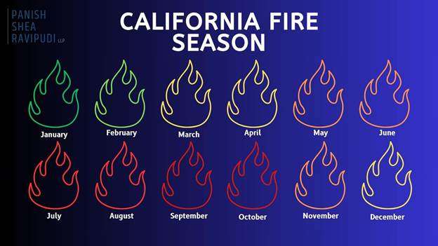
When is California’s “Fire Season”?

As thoroughly explained in an online guide from the Western Fire Chiefs Association, California fires can technically happen year-round, but peak fire season varies by region. In Northern California, it typically starts in June or July and lasts through late October or November. Whereas in Southern California, the peak season begins earlier, in late spring, and can continue through October.

Due to rising temperatures and limited rainfall these destructive firestorms are becoming more and more frequent, with California heading towards a year-round fire season, as with the devastating wildfires in Los Angeles County in January 2025.

California Fires Are Getting Worse

Due to California’s geography and climate, wildfires are not a new phenomenon and would occur regardless of the existence of humans. Yet in recent years, there has been a significant increase in the regularity of record-breaking fires in terms of overall destruction, frequency, and size. 

  • Between 1973 and 2024, the western U.S. saw an average increase of 37 extra “fire weather” days each year, typically marked by high heat, low humidity, and strong winds. This trend is especially severe in California, where these dangerous conditions now happen more often, turning what was once a seasonal threat into a year-round fire risk.
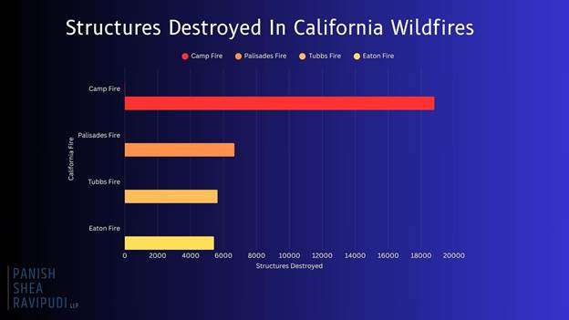
  • In January 2025, Southern California was hit by a string of intense wildfires, including the massive Palisades and Eaton Fires. Together, these blazes destroyed more than 18,000 buildings, took 30 lives, and displaced over 200,000 residents. The Palisades Fire, in particular, ranked as the third-most destructive wildfire ever recorded in the state’s history.
  • According to CAL FIRE, the top four most destructive wildfires in California history have all occurred within the last eight years.
  • Camp Fire (November 2018) 18,804 structures destroyed.
    • Palisades Fire (January 2025) 6,662 structures destroyed.
    • Tubbs Fire: (October 2017) 5,636 structures destroyed.
    • Eaton Fire: (January 2025) 5,418 structures destroyed.
  • Every year, California is confronted with more destructive, record-breaking fires that redefine the danger of California wildfires and demonstrate the dire circumstances many Californians live under. 

California Counties Most At-Risk From Wildfires


Currently, more than 2.3 million acres of land in California is considered to be “high” or “very high” risk for wildfire, with a handful of California counties containing many of these acres within their borders.

Riverside County

  • Based on Cal Fire’s Fire Hazard Severity Zone maps, large portions of Riverside County are rated as “Very High” for wildfire risk. This is increased in regions such as the San Bernardino National Forest, Santa Ana Mountains, and areas around Palm Springs and Temecula.
  • FEMA ranks Riverside County as one of the highest-risk areas for wildfires in California, giving it a maximum risk score of 100%. The county is projected to lose an estimated $319 million each year due to wildfires.
  • Over 70% of structures in Riverside County are at risk of wildfire damage.
  • With an ever-growing population of more than 2.5 million, the risk of wildfires in Riverside County remains a constant danger to the populous.

San Diego County

  • According to updated CAL FIRE maps, San Diego County has seen a 26% increase in areas classified as “Very High Fire Hazard Severity Zones,” growing from about 647,000 to over 871,000 acres. What’s especially concerning is that more urban neighborhoods are now falling within these high-risk zones.
  • Many communities are situated in the Wildland-Urban Interface, where development meets undeveloped wildland, increasing the potential for property damage and loss to wildfires.
  • Several San Diego County cities, including Chula Vista, Del Mar, Carlsbad, Poway, Santee, and San Marcos, have experienced a 10% minimum increase in areas classified as “Very High Fire Hazard.” Poway, in particular, now has nearly 80% of its total land area designated within this most severe fire risk zone.

San Bernardino County

  • With a population exceeding 2 million, many residents live in areas classified under high to very high fire hazard severity zones.
  • Urbanization has led to previously undeveloped high-risk regions being populated, increasing the number of homes and structures at risk.
  • Many cities such as Big Bear Lake, Chino Hills, Colton, Fontana, Hesperia, Rancho Cucamonga, Redlands, Rialto, San Bernardino, Upland, and Yucaipa fall within the very high fire hazard severity zone.
  • Approximately 53% of buildings in San Bernardino are at risk of wildfire, with a high-risk level.
  • San Bernardino experiences increased drought conditions, contributing to heightened wildfire potential.

Los Angeles County

  • In March 2025, CAL FIRE’s updated maps designate extensive areas in Los Angeles County as “Very High Fire Hazard Severity Zones including cities such as Los Angeles, Malibu, Pasadena, Santa Clarita, and Glendale.
  • Los Angeles’ “Very High Fire Hazard Severity Zones” expanded from 646,838 acres in 2011 to 817,212 acres in 2025.
  • Urban expansion into grasslands and timberlands has increased the population now living in the Wildland-Urban Interface (WUI) hazard areas.
  • Areas where wind-blown embers can ignite distant structures now affect approximately 1.3 million structures in Los Angeles County.

Ventura County

  • 88,000 acres in Ventura County fall into the “very high” fire hazard category, a 54% increase from previous years.
  • Many communities in Ventura County are located where urban neighborhoods meet wildland areas, which raises the risk of wildfires threatening homes and critical infrastructure.
  • Almost 80% of buildings in Ventura are vulnerable to wildfires, with a large number falling within high-risk zones.
  • Extended dry periods and below-average rainfall have created perfect conditions for wildfires, turning Ventura County’s fire season almost a year-round risk.

Steps to Take if You Live in a High-Risk Wildfire Area

If you live in an at-risk area for a wildfire, as many Californians do, there are precautions and actions you can take in the event of a wildfire in your area.

Before a Wildfire

  • Regularly clean roofs, gutters, decks, and patios of leaves, pine needles, and other flammable debris.
  • Store gasoline and other flammables in approved containers away from the structure.
  • Attach garden hoses long enough to reach all areas of your property.
  • Keep firefighting tools accessible.
  • Review and update your insurance policies.
  • Videotape your home and possessions periodically for insurance documentation purposes.
  • Create and practice a wildfire evacuation plan, including routes and safety procedures.
  • Keep essential personal items (e.g. passports, birth certificates, photographs, valuable jewelry) in an easy to access location.
  • Build and store accessible emergency supply kits for each member of the household.
  • Remove flammable vegetation and materials within at least 30 feet of your home.

During a Wildfire

  • Stay informed on evacuation orders and the direction of the fire.
  • Gather all essential belongings and emergency kits in preparation for evacuation.
  • Follow a pre-planned evacuation route.
  • Listen and follow the directions of first responders.
  • Be prepared to either drive or evacuate on foot.
  • Secure all pets.
  • Remain calm.

After a Wildfire

  • Only return home when authorities say it’s safe.
  • Inspect your property for structural damage, gas leaks, and electrical issues.
  • Watch for hotspots, ash pits, or weakened trees and structures.
  • Report the damage and start the claims process as soon as possible.
  • Speak to a wildfire attorney

Click here to read the full report.


Understanding circumpolar wildland fire capabilities: Wildfires in the Arctic

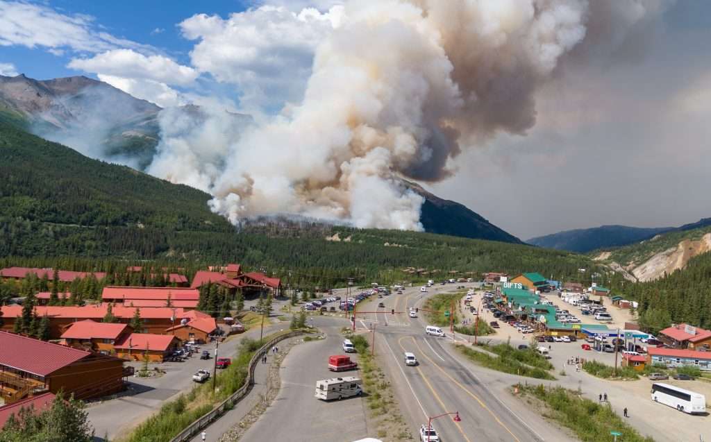
The Riley fire started June 30, 2024, near Denali National Park and Preserve in Alaska. It spread quickly, requiring park staff to evacuate. All photos by Troy Bouffard.

By Troy Bouffard and Edward Soto

The Arctic is undergoing profound environmental shifts, marked by unprecedented warming and ecosystem changes. A critical consequence of this transformation is the rise of extreme wildland fire events across all eight Arctic states, especially the United States (Alaska), Canada, and Russia.

These fires represent a shared northern challenge, transcending borders and impacting everything from carbon release and permafrost degradation to air quality and community safety. While bilateral cooperation on firefighting resources exists, notably between Canada and the United States, a comprehensive, circumpolar platform for collaboration on wildland fire preparedness, mitigation, and response has yet to develop. This gap highlights the need and opportunity for a shared understanding of how each Arctic nation manages wildland fire events.

This article is from a special issue of Wildfire magazine from the International Association of Wildland Fire and the Arctic Council. In this issue scientists, policy experts, community and Indigenous leaders provide clear insights on what is occurring with wildland fire in the Arctic and how best to respond, locally, nationally and internationally.

The Riley fire started June 30, 2024, near Denali National Park and Preserve in Alaska. It spread quickly, requiring park staff to evacuate. All photos by Troy Bouffard.

The Arctic Council Emergency Prevention, Preparedness, and Response (EPPR) Working Group publication, Circumpolar Arctic Wildland Fire Operational Baseline Report, aims to fill this research gap by establishing a foundational understanding of the existing operational capabilities and primary information sources for wildland fire response within each Arctic state.

The report’s value lies in presenting each nation’s operational picture, identifying potential areas for enhanced collaboration, and providing policymakers, operational decision makers, and researchers with the necessary baseline knowledge to engage in further studies and activities. By surveying existing governance operational structures, response systems, information resources, and logistical support mechanisms, the report serves as an important information source toward developing more integrated and effective circumpolar wildland fire management strategies in a rapidly changing Arctic.

OPERATIONAL LANDSCAPES

The report details the diverse approaches each Arctic nations takes toward wildland fire management, reflecting differences in operational governance, geography, and historical fire regimes, which can vary significantly depending on traditional management approaches and risk levels.

CANADA

Wildland fire management primarily falls under provincial and territorial jurisdiction, with the federal government responsible for Parks Canada and military lands. The Canadian Interagency Forest Fire Centre (CIFFC) plays a crucial coordinating role, facilitating resource sharing (personnel, equipment, aircraft) and information exchange both domestically and internationally, particularly with the United States through compact agreements.

By July 7, the Riley fire fire was 31 per cent contained, and evacuation status in the Denali Borough was lifted. The park resumed normal operations but some areas remained closed while crews continued to fight the fire.

Canada uses the Canadian Wildland Fire Information System for predictive services and situational awareness, incorporating data from the Meteorological Services of Canada and the Canadian Forest Fire Danger Rating System. The Canadian Armed Forces may provide support to civil authorities when requested and civilian resources are overwhelmed. Response uses a standardized incident command system, adapted for Canadian use, ensuring interoperability. Resource warehousing is also decentralized at the provincial / territorial level.

THE KINGDOM OF DENMARK (INCLUDING GREENLAND)

Denmark presents a unique structure where both civil and military emergency response capabilities reside under the Ministry of Defence, primarily executed by the Danish Emergency Response Agency (DEMA). Response follows the Emergency Preparedness Act and the National Crisis Management System, adhering to a sectoral principle for assigning responsibilities.

Given Greenland’s vast ice cover and Denmark’s relatively low wildland fire frequency, the focus is largely on an all-hazards approach with a structural fire emphasis. The Danish Meteorological Institute provides weather data, contributing to fire danger indices, often focused on agricultural settings. Response typically starts at the municipal level, escalating to DEMA if needed. Specific wildland fire equipment exists but is integrated within the broader rescue service resources.

FINLAND

The Ministry of the Interior, through its rescue services and regional rescue departments (managed by wellbeing services counties), leads wildland fire response as part of an all hazards mandate under the Rescue Act. The Finnish Defence Forces provide assistance (equipment, personnel, expertise) when requested by civil authorities. The Finnish Meteorological Institute provides essential weather and predictive services, including a forest fire index, which can trigger aerial surveillance flights. Due to intensive forest management, large wildland fires are relatively rare. Resource coordination occurs between wellbeing services counties, with the ministry coordinating international aid. Finland uses the Virve communication network, interoperable with Nordic counterparts via TETRA., the public safety telecommunications network. Training is conducted via the Emergency Services Academy Finland, emphasizing all-hazards response.

ICELAND

Civil authorities, specifically the Department of Civil Protection and Emergency Management under the National Commissioner of the Icelandic Police within the Ministry of Justice, have the sole lead for emergency response. There is no military, though the Icelandic Coast Guard assists in maritime areas and can be involved in suppressing remote wildland fires. The Civil Protection Act provides the framework for an all-hazards response structure from national to municipal levels. Wildland fires have been historically rare due to fuel types, though this may change with climate warming. Consequently, specific wildland fire information sources and specialized training are limited.

The Icelandic Meteorological Office provides general weather forecasting but focuses on more prevalent hazards such as volcanoes and avalanches. Response follows established civil protection plans, resourced locally first, with escalation pathways nationally and through the EU Civil Protection Mechanism.

NORWAY

Responsibility is shared between the Ministry of Justice and Public Security (primary authority via the Directorate for Civil Protection – DSB) and the Ministry of Defence. The DSB provides administrative oversight, while operational response resides with municipal fire and rescue services. The Norwegian Civil Defence and the Armed Forces / Home Guard can provide reinforcement and disaster assistance when needed, forming the total defence concept. Norway uses a unified management system, adapted from the incident command system, but command typically remains at the municipal level. The Norwegian Meteorological Institute collaborates with DSB, utilizing an adapted Canadian Fire Weather Index for risk assessment specific to Norwegian conditions. Resources are primarily municipal, with some national assets such as DSB-administered helicopters available during fire season or high danger periods. Norway also uses European resources such as the Copernicus Emergency Management Service (CEMS) and the Emergency Response Coordination Centre (ERCC).

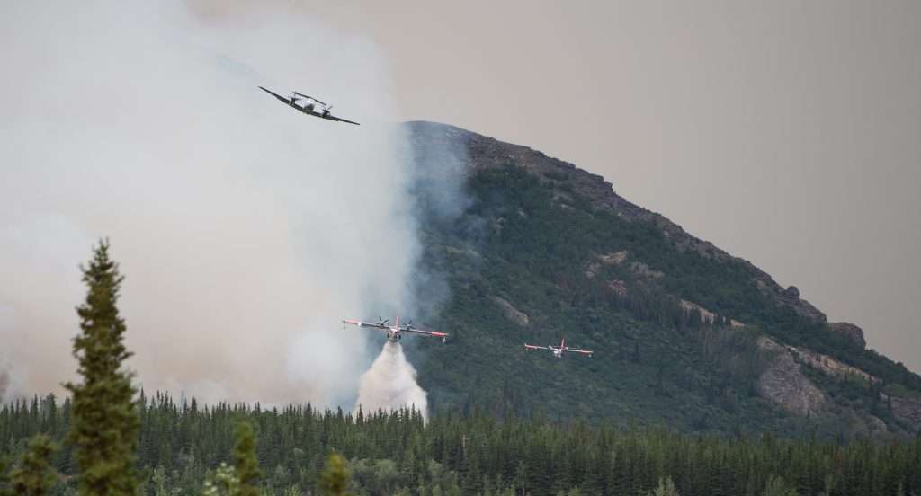
Every aircraft in Alaska that has a tank has been active on this fire today,” Danali Park public information officer Paul Ollig told alaskasnewssource.com on June 30, 2024.
Every aircraft in Alaska that has a tank has been active on this fire today,” Danali Park public information officer Paul Ollig told alaskasnewssource.com on June 30, 2024. Photo Troy Bouffard

THE RUSSIAN FEDERATION

The Federal Forestry Agency (FFA), under the Ministry of Natural Resources and Environment, is the lead agency for wildland fire protection and suppression, operating through territorial authorities. The Forest Code and federal law On Fire Safety define responsibilities, assigning coordination functions to the FFA, which establishes federal and regional headquarters. The Ministry of Emergency Situations, known as EMERCOM, handles fires in populated areas and provides support, while the Ministry of Defense’s Forestry Department manages fires on defense lands. Authority is delegated to the subjects (regions) of the Russian Federation, which develop annual consolidated fire suppression plans detailing resources (personnel, machinery, equipment) from various state, municipal, and other involved entities. The FFA oversees information reliability and coordinates interregional manoeuvring of resources. The Russian government’s Aerial Forest Protection Service (Avialesookhrana) provides specialized aviation resources, including aircraft and parachute firefighters.

SWEDEN

The Swedish Civil Contingencies Agency (MSB), under the Ministry of Defence, holds responsibility for civil protection, public safety, and emergency management, including coordinating and supporting roles in large wildland fires. Operational response is led by municipal fire and rescue departments. Sweden employs a total-defence concept incorporating emergency preparedness and civil defense, involving collaboration among government agencies, municipalities, regions, industry, and NGOs. The Swedish Meteorological and Hydrological Institute provides fire risk assessments using the Canadian Fire Weather Index during the fire season. Response is resourced locally / regionally, with cross-border municipal agreements and support from MSB, which maintains equipment depots and coordinates national / international aviation assets, including rescEU resources hosted in Sweden. If resources become scarce, MSB can prioritize allocation.

THE UNITED STATES

Wildland fire response is characterized by extensive interagency cooperation, coordinated nationally by the National Interagency Fire Center (NIFC). NIFC integrates federal agencies within the departments of agriculture and interior, state forestry agencies, and others under common incident command procedures and safety guidelines. The Department of Defense provides support to civil authorities upon request from NIFC, typically as a surge capability. Information sources are coordinated, with National Oceanic and Atmospheric Administration / National Weather Service providing key weather and predictive services. Firefighter qualifications and operational standards are standardized nationally through the National Wildfire Coordinating Group. Resources (personnel, aviation, equipment, supplies) are managed through interconnected interagency systems – Incident Qualifications and Certification System (IQCS), Interagency Resource Ordering Capability (IROC), National Fire Equipment System (NFES) caches –allowing for efficient mobilization from local to national levels. Unmanned aerial vehicles are increasingly integrated into operations.

CROSS-BORDER COOPERATION: NORDRED, RESCEU AND THE NORDIC REGION

Beyond national capacities, regional cooperation mechanisms significantly enhance response capabilities, particularly in the Nordic region. Nordred facilitates rescue collaboration (information sharing, operations) among Denmark, Finland, Iceland, Norway, and Sweden, supported by agreements at both national and cross-border municipal levels. Additionally, these nations, along with other European countries, participate in the EU Civil Protection Mechanism and its rescEU component, which provides a reserve of resources, including firefighting aircraft, coordinated through the Emergency Response Coordination Centre for international assistance. These frameworks are integral to Nordic preparedness and response culture.

This baseline report illuminates the diverse, yet often complementary approaches Arctic nations employ to manage wildland fires. While significant operational collaboration already exists within subregions such as North America and the Nordic countries, facilitated by shared systems (such as variations of the incident command system), common standards, and established agreements (such as forest fire compacts and Nordred), the frameworks and capabilities are not yet fully interoperable across the entire circumpolar Arctic.

The inventory reveals each Arctic state’s operational governance structures, key information sources (weather, predictive services, geospatial data), response protocols, and resource management systems. This foundational knowledge is crucial for identifying commonalities that can be leveraged for broader cooperation and gaps that require attention and development. As the Arctic continues to warm and wildland fire regimes intensify, understanding these national operational baselines is paramount.

Troy Bouffard, U.S. Army (Ret.), has a master’s degree in Arctic policy and a PhD in Arctic defense and security from the University of Alaska Fairbanks. He is the director of the UAF Center for Arctic Security and Resilience. Bouffard is a research fellow with the United States Military Academy – Modern War Institute. He was also the former Arctic Advisor to U.S. Senator Lisa Murkowski as a congressional fellow.

Edward M. Soto, Col, USAF (Ret.) has a forest engineering degree with a graduate certificate in Arctic securities and currently works as a project manager for the Alaska Division of Forestry. His military service includes two command tours in civil engineering and aircraft maintenance. Soto has also worked as a forest engineer and in wildland fire management throughout Alaska when not in military service.

Passing of one of the last of the Triple Nickle smokejumpers

Sgt Joe Harris, one of the last of the 555 Triple Nickles, with wildland firefighters. From left to right: Neil Gallagher, Joe Harris, Jarred Barron and Siavash Mahgerefteh.

By Neil Gallagher

On March 15, 2025, Sgt. Joe Harris, one of the last surviving members of the 555th Parachute Infantry Battalion, known as the “Triple Nickles,” passed away in Compton, California, at the age of 108. He was three months short of turning 109. His remarkable life and service are a testament to courage, resilience, and patriotism.

The Formation of the 555th

Born on June 19, 1916, in Westdale, Louisiana, Joe Harris enlisted in the U.S. Army in 1941 at 25. Enlisting into the segregated U.S. Army, Harris volunteered for paratrooper training, joining the newly formed 555th Parachute Infantry Battalion in 1943. This unit was the first all-Black airborne battalion in the U.S. Army, a significant milestone in the ongoing struggle for racial equality within the armed forces.

Nicknamed the “Triple Nickles,” their name derived from a play on their numerical designation and a nod to the Buffalo Soldiers of the 92nd Infantry Division. The 555th was composed entirely of African American soldiers, including officers. Though the Army looked to send the 555th overseas as combat replacements during the Battle of the Bulge, the unit would remain stateside, a decision influenced by the racial prejudices of the time. Despite their rigorous training and readiness for combat, the Triple Nickles did not deploy overseas to combat the enemy abroad; however, the unit would soon combat a different kind of enemy.

Operation Firefly

Between 1944 and 1945, Japan launched over 9,000 incendiary balloon bombs, known as “Fu-Go,” across the Pacific Ocean, aiming to ignite forest fires and cause panic throughout the United States. In response, the U.S. military initiated “Operation Firefly,” a classified mission to combat these threats.

The Triple Nickles were assigned to this operation and served as smokejumpers, becoming the first military smokejumpers in history. Stationed at Pendleton Army Air Field in Oregon and Chico, California, the battalion trained extensively in firefighting techniques, preparing to parachute into remote areas to extinguish fires and neutralize unexploded ordnance. The mission was kept classified to prevent public hysteria and limit information from reaching Japan regarding the effectiveness of these bombs. Although six people were killed near Bly, Ore., when they discovered a downed balloon in May 1945, the overall damage caused by the weapons was limited.

During the operation, the 555th completed 1200 parachute jumps and responded to 36 fires across Oregon, Washington, California, and Montana. Their efforts mitigated the threat of widespread fires and laid the groundwork for aerial firefighting techniques still in use today. Despite these efforts, Operation Firefly remained classified for years, and Sgt Harris and the men of the 555th received little recognition.

Sgt. Joe Harris: A Lifetime of Service

Throughout his service in the U.S. Army, Sgt Joe Harris completed 72 parachute jumps and was eventually injured on a jump when his chute did not fully deploy. After his honorable discharge in 1945, Harris continued serving our nation by joining the U.S. Border Patrol. He later settled in Compton, California, where he became a respected figure in his community, known for his wisdom and leadership.

Enduring Legacy and Recognition

Despite their significant contributions, the Triple Nickles’ story remained largely untold for decades. However, recently, efforts have been made to honor their legacy. In 2017, a historical marker was unveiled at the Siskiyou Smokejumper Base Museum in Cave Junction, Oregon, commemorating the battalion’s service during Operation Firefly.

Moreover, the battalion’s integration into the 82nd Airborne Division post-war marked a significant step toward desegregation in the U.S. military, predating President Truman’s Executive Order 9981 by over six months.

During the LA fires this past January, Marine Corps veterans and former Wildland Firefighters Jarred Barron, Siavash Mahgerefteh, and Neil Gallagher visited Mr. Joe Harris at his home in Compton, California. During the visit organized by Gallagher, the group presented Mr. Harris with a U.S. Army Paratrooper Patch, and Mahgerefteh presented Harris with a Pulaski Axe, a tool both Harris and the group used during their respective fire service. The California Department of the American Legion featured the visit.

Sgt Joe Harris, one of the last of the Triple Nickles, the 555th Parachute Infantry Battalion, passed away in March 2025 at the age of 108.

The funeral for Mr. Harris, held in Inglewood, California, on April 5th, lasted over three hours, with guests traveling across the country to pay their respects. Speakers included members of the Harris family, friends, community members, veterans, and the mayor of Compton. Firefighters from the Angles National Forest were in attendance, and Soldiers from the 82nd Airborne Division conducted military burial honors.

Read the LA Times account of the funeral.

Sgt. Joe Harris’s life and service continue to inspire, reminding us of the courage and determination of those who fought battles both abroad and at home. His legacy lives on through his family, including his grandson Ashton Pittman, who underwent paratrooper training to honor his grandfather’s memory. Mr. Harris is survived by two daughters, one son, four grandchildren, 15 great-grandchildren, and 20 great-great-grandchildren.

As the greatest generation continues to fade away, we must ensure the sacrifices made by these men and women are not lost to time. Men like Mr. Harris paved the way for servicemembers and firefighters for generations to come.

Sgt Joe Harris, one of the last of the Triple Nickles, the 555th Parachute Infantry Battalion, passed away in March 2025 at the age of 108.

Neil Gallagher is a former wildland firefighter with the Bureau of Land Management and a Marine Corps Veteran. He runs Preserving the Stories, a veteran’s oral history nonprofit that seeks to preserve the legacies of WWII, Korea, and Vietnam veterans. Additionally, Neil is a law student at the University of California, Berkeley.

LA Fires – Burning Cities

Idaho Taskforce 4 experiencing southern California traffic en route to the Palisades fire on Saturday, Jan. 11. Photo Kelly Martin

By Lindon Pronto

We have entered an operational gray zone: wildfires burning in cities. These fires are the jurisdiction of urban fire departments, but often they rely on wildland firefighters to get the job done, and wildland firefighters are increasingly being called to fight wildfires in urban environments.

During the breaking news frenzy around large wildland fires, I rarely say what I really want to say – it’s a game of responding to sensational and reactionary questions, just like how we approach fire itself. So, here’s what I’ll add to the discussion about the LA fires.

This is an edited version of an article in Wildfire Magazine Special Edition: LA Fires

There will be a lot to learn. And some officials and organizations are going to need to take some responsibility. And certainly, residents in fireprone landscapes need to contemplate their own responsibilities. But these are the two fundamental questions I see that we need to address:

  1. What will be collectively required of us to prevent such disasters in the future?
  2. How will we respond to similar disasters when they occur?

Since the January fires, news stories, op-eds and social media have been swirling with lots of great propositions to these questions: more prescribed fire, fire-hardened construction (hempcrete!) and landscaping, better urban planning, building codes, budget priorities, public utility SOPs, fire-tech, etc. I think the answers to how to address question 1 are relatively straightforward – experts have been sounding the alarm and offering solutions on these issues for decades. Answering question 2 is more challenging.

Looking at the long list of things to address to prevent such a disaster from happening again, it’s obvious the changes, motivation, behavioral shifts, policy response and funding needed mean we will likely have many more devastated communities long before these changes come to fruition. This brings us to question 2 –the burden on the conscience of the collective response community. At the end of the day, we all still expect firefighters to respond, as they have always done.

Fire fighting is siloed: there are many types of firefighters from municipal and state to industrial, airport, and maritime. To oversimplify in the California context, there are wildland firefighters and urban / structure firefighters, and some who do a bit of both, especially in California, known for its wildland-urban interface.

CAL FIRE is an example of an agency that evolved to do both. Los Angeles County Fire is another example. But fundamentally, wildland firefighters are trained and equipped differently and operate tactically and strategically different than urban fire departments.

I’m not knocking one group of firefighters; I’m just saying we don’t expect a smokejumper to run into a burning building. But we do expect urban fire departments to manage the most complex and extreme wildfires, ordering outside resources as needed.

But telling an urban firefighter not to extinguish a burning building goes against every instinct. This was apparent in the LA fires – urban firefighters pumping massive quantities of water through large-diameter fire hoses on fully involved structures. In other words, valiantly using the equipment they have, to do exactly what they were trained to do. Urban firefighters are a stationary firefighting force whose objective is to tap into the nearest fire hydrant; the fire truck serves as pumping platform and the firefighters are committed to this effort until the structure is fully extinguished. This is obviously an untenable approach if a sea of structures is on fire during a wind event. Houses and cars, businesses and schools – all on fire. Instead of trees and bushes, it’s a jungle of petroleum products and biomass – a devastatingly overwhelming situation.

Wildland firefighters are trained not to fight a house on fire but to stop it from spreading to the surrounding area. Wildland firefighters operate very differently; their initial objective is not to extinguish a fire but to rob it of available fuel to eventually contain its spread. This is why wildland firefighters are very mobile, and move with the progression of the fire, often doing so without relying on water, or at least very little water.

Looking ahead, I believe the response community does need to think outside the box when it comes to this new operational gray zone. Firefighters will be called into these scenarios in the future, and to answer that second question, adaptations in our strategies, tactics, and use of resources need to be addressed. Maybe we can learn a thing or two from the wildland fire community – after all, as the Washington Post reported, LA has long been over-dependent on wildland firefighting agencies like the U.S. Forest Service to handle fire in the city and county’s jurisdiction.

Lindon Pronto (M.Sc. environmental governance) has more than 20 years of experience and expertise in wildfire management with employment, research, deployments, and remote support in more than 30 countries in the Americas, Europe, Asia, Africa, and the Middle East. Pronto has years of operational experience as a federal wildland firefighter in California.

LA Fires – Reconnaissance

In Malibu and Altadena, roadblocks with National Guard military vehicles, armed soldiers and / or LAPD officers kept looters out of neighborhoods where utilities had been shut off and residents had evacuated. Photo Michael Scott-Hill

By Michael Scott-Hill

In mid-January I was sent on a military company assignment to recon the Los Angeles fires and use the experience to teach our leadership staff about wildfire. I was in Australia and was flown to California. As I packed, I turned on the TV and saw footage – big flames, heroes, victims and their stories, political blame slinging, shouts of incompetence, and lots of videos of fire aviation operations.

I arrived in Southern California and linked up with my small team of corporate leaders. I was their wildfire expert and the next day, after the red flag weather forecasts for Santa Ana winds lifted, we headed down the coast to visit the tragic wake of the Pacific Palisades fire.

[This is an edited extract of a longer article on the author’s observations from his assignment on these fires taken from Wildfire Magazine Special Edition: LA Fires.]

Having spent a career around the US Forest Service wildfire operations, the footprint of wildfire response was familiar: inbound structural city firefighting engines in short convoys; task forces; tents; trucks; trailers; staged fire equipment; and crews waiting at an oceanside incident command post. There were no federal fire response rigs, just CAL FIRE local fire response vehicles, and many law enforcement patrolling to deter arsonists and looters.

The Pacific Coast Highway between the coastline and where the rolling hills – with their brush and dried grass – climb upward among homes. Photo Michael Scott-Hill

PERSPECTIVE FROM YEARS OF BURNING

Days later, flying back to Australia, I processed all I had experienced.

I’ve worked on countless wildfires with the US Forest Service, yet these LA fires were unique. No matter how each began, did the fires have to be as bad as they turned out to be?

Thirty-two years ago, I had been a wildland firefighter stationed in Southern California and earned my place on the Los Padres Hotshots. In 1993 we successfully fought several wildfires sometimes driven by Santa Ana winds.

I learned that the fire regime in California is ancient in its cyclic patterns. I was taught about weather patterns and fire fuels; we specialized in working the big fires along the urban fringe. Southern California is one of the world’s most wildfire prone areas, and its wildfire flames have the potential to mix with its people – and often do.

In Southern California many people craft comfortable lives, using technology to distance themselves from the realities of the natural world: air conditioners and beautiful shady yards insulate the people from the natural hot, often harsh, landscape.

What has changed in the Southern California wildfires since I was a young hotshot?

The tactics employed in fighting wildfires have shifted – at least in California – to promote situations for large fire growth using indirect attack strategies. Weather patterns worldwide have shifted, causing fire seasons to be altered in locations; and of course, there are financial realities that make wildland fire fighting no longer as attractive a profession as it once was.

There are factors in Southern California that won’t change. The hot sun will shine. The grass and brush will grow, and this vegetation will cure and die in its normal life cycles. The Santa Ana winds will always blow in strong from Nevada and race over the hills. Wildfires will always start naturally, by accident, or arson.

Piles of yard vegetation to be chipped had been cut by contracted crews awaited mobile chippers. The hazard-reduction operation continued into areas untouched by fire, to reduce future fuels. Photo Michael Scott-Hill

Which of these factors can be modified by humans? Fuels that fires consume can be managed to reduce accumulation (loading) that builds up over time. Wildfires need fuel to take hold and grow, just as they need ignition sources. The wildfire fuels typical of Southern California, such as dried grass, brush and timber, all have predictable cyclic points in their life cycles when they are ready, able to carry, and to be consumed by fire.

In Southern California when I was working there, urban interface zones and Santa Ana winds were always factors; they were dangerous, so we learned about them and used that knowledge to prepare for all that could happen. Could the LA Emergency Response Management apparatus have been better prepared? LA has seen urban development expand its boundaries more than its density; the interface is so much larger than it was when fire careers began. And the 30-year fire return interval in chaparral is longer than many careers. How do agencies prepare?

There are many valuable lessons in disaster management, and pre-disaster preparedness that can be pulled from the LA fires, if we take the time and effort to look carefully enough beneath the layers of smoke that might be blocking our vision.

Read the full article in Wildfire Magazine

LA Fires – a personal perspective

A single palm stands as a sentinel to the community of Palisades, emblematic of unusual life surrounding profound devastation. Photo by Kelly Martin

By Kelly Martin

This is not a reflection about who or what to blame. But blame was the tagline I was watching on TV within the first 24 hours of the Palisades and Eaton fires that wiped out swathes of communities in southern California. This is my account of what I saw and my contemplation about what comes next.

I needed to see this urban conflagration for myself. The fires were so outside my 40 years of wildland fire experience there was no rational part of my brain to reconcile what I was witnessing.

[This article first appeared in Wildfire Magazine – Special Edition: LA Fires.]

I went to bed Jan. 7 and woke up the next day to a request from California to neighboring states for help. The call for fire engines went out far and wide as an Emergency Management Assistance Compact (EMAC) request – a national disaster-relief compact that allows states to share resources during emergencies or disasters. Could it be possible that our little White Bird Fire Department (population 100) could be part of this effort? I was repeating over and over, we have to go, we have to go, we have to go. The morning of Jan. 9, I found myself loading my summertime fire gear in the dead of a snowy winter in Idaho and heading south for our two day trip to Los Angeles.

After I retired in 2019 from a 35-year career working for the US Forest Service and National Park Service I found myself volunteering for many opportunities to give back to my community and the larger wildland fire community nationally and internationally. These opportunities allow me to see things differently. I’m no longer a fire chief or a member of an incident management team; I’m no longer a supervisor. In LA, I was happy to be serving as a firefighter, as I had done in 1984 when I was humble, curious and excited for the journey ahead. We left the frigid winter of central Idaho and after two days of traveling, slowly emerged into the envelope of the warm ocean breeze along the Pacific Coast Highway. I see now why so many people are attracted to the ocean and the temperate climate. Many millions of people choose to live in LA, even with the deadly Santa Ana winds always lurking in the background. No amount of human intervention will tame the Santa Anas.

This LA assignment brought my career full circle. I remember the epiphany I had at the Grand Canyon when I was flown by helicopter to the North Rim for a wildfire response. Sleeping in the rocks, dead tired after a seven-day wilderness fire experience, I knew at that moment every day from then on would be dedicated to working as a wildland firefighter. My younger self could never have imagined my older self-responding on an engine to a wildfire in LA, suppressing flare ups behind multi-million-dollar homes, helping people recover something – anything – that was recognizable of their past lives. The extreme contrast of my first fires in the wilderness of Grand Canyon National Park and the urban conflagration of LA could not be greater. I continue to remind myself that I had, and am still having, an amazing career serving the American public, and I’m extremely proud to have been part of a national response.

During the long trip from deep-winter Idaho to summer-like conditions in Malibu, I spent a lot of time being mindful about what I was getting into: tens of thousands of homes gone, lives lost, and billions of dollars of loss that surely would take years of recovery. Our travel route took us through the heart of LA in our oversized engine in gripping traffic. As we were given the wave to pass through the roadblock on the Pacific Coast Highway, it was as if everything became quiet and the anxiety of driving in heavy traffic was gone. It was game time. There was no one on this popular highway, just our five engines in perfect spacing. Our taskforce rumbled toward the first visual of the devastation. When people tell you the scene was unlike anything anyone has ever experienced, it’s true. My first impression was how could so many buildings for miles along the Pacific Coast Highway be gone, nothing but rubble – ash, concrete and metal – large, commercial buildings just gone. How do so many buildings built literally on the ocean coast go up in flames? Truly unbelievable.

Our fire engine was assigned a very specific area to suppress hotspots and open flames. We got to know our area quite well and got to know where small spot fires could threaten containment. The physical geography of this area was my first revelation about what we were witnessing. The area was densely populated. Homes lined both sides of steep canyons; some homes were built further up the slope with incredible views of the ocean. I soon discovered why these neighborhoods were very desirable places to live.

Idaho Taskforce #4 patrolling the burned area near homes for hotspots and taking suppression action to ensure no reignition. Photo by Kelly Martin

I spent the better part of my fire career working and living in Yosemite National Park and on incident management teams, but Los Angeles County and the City of Los Angeles were new ground for me. I felt like everything was novel again. Our first assignment was along the eastern boundary of the Palisades fire. Our mission was to keep the fire from jumping the canyon and igniting highly volatile vegetation that could reignite the eastern spread and threaten more homes and lives. I felt grateful the most severe Santa Ana winds had passed, but we all felt the heavy weight of protecting multi-million-dollar homes from any further damage.

The next 14 days we covered a lot of ground throughout the Pacific Palisades area and just to the east of the fire’s edge to ensure no reignition. I was struck most by the sheer devastation, block after block of leveled buildings, but occasionally I would see a house still standing and I could not help but study these houses up close. Had firefighters been there? What was the construction of the house? How old was the house? How and why did particular homes survive? The heroic efforts of individual engine companies is likely one of the untold stories that will come out over time. For CAL-FIRE, LA City and LA County and surrounding fire departments that were called into to assist, I can’t help but try to put myself on their engines with the firefighters who did their very best – as they had been trained to do – to save life and property, watching home after home, and business after business, fall.

I saw first-hand concrete bank buildings that were but shells. How does a concrete building in the middle of town on flat terrain just disappear? My curiosity began to shift to try to understand the many factors that contributed to this devastation. Weeks later, at home, I was still processing what I saw and the people we met and helped.

The first glimpse of what was to come; major buildings on both sides of the Pacific Coast Highway were destroyed. Photo by Kelly Martin

 My experiences in LA will forever be part of my fire career: Homes reduced to ashes with Christmas decorations on their hedges and fences; miles and miles of ash, concrete rubble and twisted metal; devastated homes and buildings along the pacific coast washing into the ocean; remaining homes that did not burn that were saved by owners or firefighters and home hardening construction. Amid such destruction and devastation of life and property I looked for color among the chaos. I found small comfort in emerging new flowers, just two weeks after Jan. 7.

LA experienced a great boom after the Second World War. Houses and small lots were the first indication to me that the building boom after 1945 likely did not consider the possibility that whole communities could be destroyed by fire. Communities continued to expand into the wild, untamed fire territory. Building continued and the population surged from 3.5 million to more than 18 million by the 21st century. Combine the population growth with few if any builders or homeowners who understood home hardening or Firewise™ concepts, and the lack of building codes. Community planning 70 years ago was very different than it is today, and the number of communities still in the path of future wildfires is staggering. Devastating loss of life and property will happen again. Closely packed housing units, vegetation hedges 15 to 20 feet tall between homes, home development in steep canyons, and narrow roads – it’s clear how this catastrophic urban conflagration developed.

Kelly Martin was IAWF President in 2024. Martin retired as chief of fire and aviation, Yosemite National Park, National Park Service, Pacific West Region, in 2019.

She began her federal career as a GS-3 with the Apostle Island National Lakeshore in 1984 while attending college and worked her way up through the ranks during her 34-year career. Martin also served on the Presidential Wildland Fire Mitigation and Management Commission. She is the past chair of two National Wildfire Coordinating Group programs: Fire Environment Committee and the National Fire Management Leadership (M-582) course. Martin is a mentor and coach for the national and international Women in Fire Training Exchange (WTREX) program. She now serves as a volunteer firefighter and trainer for White Bird Fire Department in Idaho and started a fire consulting business in 2024.

Controlled burns reduce wildfire risk, but they require trained staff and funding − this could be a rough year

Nature Conservancy Prescribed Fire

This article was originally written by Laura Dee, Associate Professor of Ecology, University of Colorado Boulder, and is republished from The Conversation under a Creative Commons license. Read the original article.

Red skies in August, longer fire seasons and checking air quality before taking my toddler to the park. This has become the new norm in the western United States as wildfires become more frequent, larger and more catastrophic.

As an ecologist at the University of Colorado Boulder, I know that fires are part of the natural processes that forests need to stay healthy. But the combined effects of a warmer and drier climate, more people living in fire-prone areas and vegetation and debris built up over years of fire suppression are leading to more severe fires that spread faster. And that’s putting humans, ecosystems and economies at risk.

To help prevent catastrophic fires, the U.S. Forest Service issued a 10-year strategy in 2022 that includes scaling up the use of controlled burns and other techniques to remove excess plant growth and dry, dead materials that fuel wildfires.

However, the Forest Service’s wildfire management activities have been thrown into turmoil in 2025 with funding cuts and disruptions and uncertainty from the federal government.

The planet just saw its hottest year on record. If spring and summer 2025 are also dry and hot, conditions could be prime for severe fires again.

More severe fires harm forest recovery and people

Today’s severe wildfires have been pushing societies, emergency response systems and forests beyond what they have evolved to handle.

Extreme fires have burned into cities, including destroying thousands of homes in the Los Angeles area in 2025 and near Boulder, Colorado, in 2021. They threaten downstream public drinking water by increasing sediments and contaminants in water supplies, as well as infrastructure, air quality and rural economies. They also increase the risk of flooding and mudslides from soil erosion. And they undermine efforts to mitigate climate change by releasing carbon stored in these ecosystems.

In some cases, fires burned so hot and deep into the soil that the forests are not growing back.

While many species are adapted to survive low-level fires, severe blazes can damage the seeds and cones needed for forests to regrow. My team has seen this trend outside of Fort Collins, Colorado, where four years after the Cameron Peak fire, forests have still not come back the way ecologists would expect them to under past, less severe fires. Returning to a strategy of fire suppression − or trying to “go toe-to-toe with every fire” − will make these cases more common.

A burned landscape with black tree trunks, no canopy and little to no new growth on the ground.
Parts of Cameron Peak, burned in a severe fire in 2020, still showed little evidence of recovery in 2024. Efforts have been underway to try to replant parts of the burned areas by hand.
Bella Oleksy/University of Colorado

Proactive wildfire management can help reduce the risk to forests and property.

Measures such as prescribed burns have proven to be effective for maintaining healthy forests and reducing the severity of subsequent wildfires. A recent review found that selective thinning followed by prescribed fire reduced subsequent fire severity by 72% on average, and prescribed fire on its own reduced severity by 62%.

Four sets of illustrations. The most severe fires happened with no treatment. Thinning helps some. Prescribed burning keeps fires burning lower at the forest floor.
Prescribed burns and forest thinning tend to reduce the risk of extremely destructive wildfires.
Kimberley T. Davis, et al., Forest Ecology and Management, 2024, CC BY

But managing forests well requires knowing how forests are changing, where trees are dying and where undergrowth has built up and increased fire hazards. And, for federal lands, these are some of the jobs that are being targeted by the Trump administration.

Some of the Forest Service staff who were fired or put in limbo by the Trump administration are those who do research or collect and communicate critical data about forests and fire risk. Other fired staff provided support so crews could clear flammable debris and carry out fuel treatments such as prescribed burns, thinning forests and building fire breaks.

Losing people in these roles is like firing all primary care doctors and leaving only EMTs. Both are clearly needed. As many people know from emergency room bills, preventing emergencies is less costly than dealing with the damage later.

Logging is not a long-term fire solution

The Trump administration cited “wildfire risk reduction” when it issued an emergency order to increase logging in national forests by 25%.

But private − unregulated − forest management looks a lot different than managing forests to prevent destructive fires.

Logging, depending on the practice, can involve clear-cutting trees and other techniques that compromise soils. Exposing a forest’s soils and dead vegetation to more sunlight also dries them out, which can increase fire risk in the near term.

Forest Service crew members put tree branches into a wood chipper as they prepare the area for a prescribed burn in the Tahoe National Forest, June 6, 2023.
Forest-thinning operations involve carefully removing young trees and brush that could easily burn, with a goal of creating conditions less likely to send fire into the crowns of trees.
AP Photo/Godofredo A. Vásquez

In general, logging that focuses on extracting the highest-value trees leaves thinner trees that are more vulnerable to fires. A study in the Pacific Northwest found that replanting logged land with the same age and size of trees can lead to more severe fires in the future.

Research and data are essential

For many people in the western U.S., these risks hit close to home.

I’ve seen neighborhoods burn and friends and family displaced, and I have contended with regular air quality warnings and red flag days signaling a high fire risk. I’ve also seen beloved landscapes, such as those on Cameron Peak, transform when conifers that once made up the forest have not regrown.

Burned trees and weeds in the ground below.
Recovery has been slow on Cameron Peak after a severe fire in 2020. This photo was taken in 2024.
Bella Oleksy/University of Colorado

My scientific research group and collaborations with other scientists have been helping to identify cost-effective solutions. That includes which fuel-treatment methods are most effective, which types of forests and conditions they work best in and how often they are needed. We’re also planning research projects to better understand which forests are at greatest risk of not recovering after fires.

This sort of research is what robust, cost-effective land management is based on.

When careful, evidence-based forest management is replaced with a heavy emphasis on suppressing every fire or clear-cutting forests, I worry that human lives, property and economies, as well as the natural legacy of public lands left to every American, are at risk.The Conversation

Laura Dee, Associate Professor of Ecology, University of Colorado Boulder

This article is republished from The Conversation under a Creative Commons license. Read the original article.