India state’s officials blame pine trees for wildfire severity. Experts say that isn’t the full story.

An article written by The Wire author Hridayesh Joshi breaks down systemic issues facing the wildland firefighting force in Uttarakhand, India.

More than 1,200 forest fires burned this year in Uttarakhand and claimed the lives of at least ten people, including some forest guards. In response, state officials have orchestrated a statewide campaign against pine tree litter, called “Pirul Lao-Praise Pao,” or “Bring Pine Litter, Take Away  Money.” The program incentivizes locals to collect piles of pine needles that litter the state’s forest floor. Uttarakhand Chief Minister Pushkar Singh Dhami even recorded himself scraping up pine needles to promote the program.

“Under the campaign ‘Pirul Lao-Paise Pao,’ a large number of people are collecting pine needles and selling it to the government at the rate of ₹ 50/kg,” (about 60¢ USD per 2.2 lbs.) Dhami said. “At present, due to this campaign, the incidents of forest fire have reduced significantly and the villagers living near the forest area are also earning income.”

In May, the Uttarakhand government suspended 10 frontline Forest Department employees as nearly 1,350 hectares (3,336 acres) of Himalayan hills remained burning for nearly a month. The decision to suspend the forest guards and foresters followed an emergency meeting of senior government officials with Chief Minister Dhami. He postponed his scheduled engagements to chair the meeting with the Forest Department officials.

“Ten employees have been suspended in different areas,” he said, “five were attached to the forest headquarters and two were issued showcause notices for dereliction of duty leading to massive fire incidents since April 1.”


Trivendra Singh Rawat was the first Chief Minister in the state to start a pine needle collection program by linking it to the Mahatma Gandhi National Rural Employment Guarantee Act (MGNREGA) after coming to power in 2017, according to the Statesman.

“Around 25 lakh (~2.5 million) metric tonnes of pine needles are produced annually in the state,” Rawat said. Researchers at India’s  Central Institute of Agricultural Engineering found that pine needles, if heated with an absence of oxygen through pyrolysis, could be converted into a bio-oil and used in blended fuels. Rawat estimates that volume of pine needles could generate nearly 200 MW of power.

Experts, however, say the state’s narrative focus on pine needles as the cause of wildfires misses the mark because pine duff is an easy scapegoat for government officials to focus on rather than the more systemic issues of inadequate forest staff, drought, and a widespread absence of fire breaks.

“One could argue this campaign was the government’s attempt to pivot the blame away from grim ground realities and solely toward these aged pine trees,” Joshi wrote. He said, instead of addressing all these issues together, the Uttarakhand government’s decision to “villainize” one species is a myopic strategy and will prove to be detrimental in the long term. Pine is just one conifer standing among many other species on the Himalayan slopes. Focusing solely on pine shows the government’s misunderstanding of the larger Himalayan ecosystem and is leading to unsustainable solutions to the forest fire issue.

Pine trees have made up an integral part of India’s mountain forest cover since the Himalayas first formed. Collection of pine needles alone won’t be enough to control forest fires, experts told Joshi. Instead, the state should create a more holistic approach that addresses the human causes of forest fires.

Read the full article here.

factors

World’s largest tropical wetland burned this year

Record-breaking wildfires between January and June burned an ecological foothold — and biodiversity haven — spanning across Brazil, Bolivia, and Paraguay this year, just four years after similar fires burned 13,300 acres of the preserve.

The Pantanal is considered the world’s largest tropical wetland area, the world’s largest flooded grasslands, and one of the most important areas of freshwater in the world.

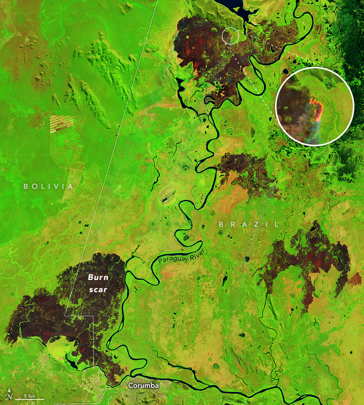
NASA captured some of the intense fires’ burn scars in satellite imagery.

“Fire season in southern Brazil usually starts in July and peaks in August and September,” NASA said. “The false-color images emphasize the burn scars (brown) from several of the fires. Unburned vegetation is green. Near- and short-wave infrared bands help penetrate some of the smoke to reveal the hot spots associated with active fires, which appear orange.”

Pantanal fires
Pantanal fires June 2024

The repeated fires have left the environment in a state of constant recovery — and nearby communities are struggling.

“We were just trying to recover from the 2020 fire, which devastated our Pantanal. We had not fully recovered and now we are facing this again,” said a volunteer firefighter with the Baia Negra Environmental Protection Area’s Association of Women Producers.

A recent report from MapBiomas Brazil, a collaborative initiative including NGOs, universities, and technology companies, sheds light on a major cause of the fires: surface water loss.

Edge effects
Edge effects on the native vegetation and continuous habitat — including exposure to wind and solar radiation, susceptibility to fire, increased predation rates, and

The Pantanal is the biome in Brazil that has dried up the most between 1985 and 2023. The report said annual water surface for the area last year was just under 944,000 acres — only 2 percent of the wetland biome was covered by water. The total is reportedly 61 percent under the historical average. The area was 50 percent drier in 2023 than it was in 2018 when the area’s last major flood happened.

“In 2024, we didn’t have a flood peak,” said Eduardo Rosa with  MapBiomas. “The year has seen a peak drought, which should last until September. The Pantanal in extreme drought is already facing fires that are difficult to control.”

The report also found that the entire Amazon region suffered a severe drought with a decrease of 8.2 million acres of water surface.

Up to 25% of Brazil’s native vegetation may be degraded

A new platform from the MapBiomas network shows that between 1986 and 2021 Brazil had between 11 and 25 percent of its native vegetation susceptible to degradation. This corresponds to an area ranging from 60.3 million hectares to 135 million hectares.

Fire effects over time
Visualized fire effects over 7 years, resulting from a single burn or multiple burns.

About 64 percent of Brazil — more than half the country — is covered by native vegetation. The beta version of MapBiomas’ degradation vectors platform makes it possible to generate unprecedented scenarios of the impact of factors that can cause degradation on native vegetation across  Brazil.

“This is the first time that degradation can be assessed in a broader way and in all Brazilian biomes,” says Tasso Azevedo, general coordinator of MapBiomas. “But we know that this degradation process occurs in other types of cover, such as agriculture and pasture, as well as soils and water, where we also intend to advance with this information in MapBiomas in the coming years.”

  ➤ View the main highlights [PDF] of the Degradation module

The degradation vectors considered by the MapBiomas team in this first edition of the platform include the size and isolation of the native vegetation fragments, their edge areas, the frequency of fire and the time since the last burn, as well as the age of the secondary vegetation.

Pantanal: fire as a factor in degradation

In the Pantanal, the degraded area can vary from 800,000 hectares (6.8 percent) to 2.1 million hectares (almost 19 percent). Although it is a biome that coexists with fire, the incidence of fires in the last five years has meant that 9 percent of the Pantanal’s forest formations, which are fire-sensitive areas, have been damaged.

Eduardo Rosa with the MapBiomas’ Pantanal team says some of the vectors of degradation in the Pantanal beyond this analysis must consider the entire biome’s surroundings, since all the rivers that naturally irrigate the Pantanal plain are born in plateau areas. “The removal of native vegetation for agricultural and livestock expansion unprotects the soil and interferes with the distribution of water and sediment. The quantity and quality of water that reaches the plains also depends on dams and hydroelectric plants that alter the natural flow of water,” he says. “Climate issues relating to rainfall and temperature regulate droughts and floods, and the increase in periods of drought has hampered the resilience of the Pantanal ecosystem.”


Turkish wildfires threaten historic sites, ancient city of Assos

Turkey’s General Directorate of Forestry is battling a much higher number of wildfires this year compared with 2023; at this time last year, the country had recorded 513 forest fires, 665 other fires, and nearly 1500 total acres burned. As recently as June 24, those numbers have grown to 1093 forest fires, 1029 other fires, and nearly 8300 acres burned.

Aljazeera reported that at least 11 people were killed and dozens hurt as wildfires burned through villages in southeastern Turkey. Health Minister Fahrettin Koca reported the deaths from the overnight blaze between the cities of Diyarbakir and Mardin on Friday. Seventy-eight people were injured, with at least five people in intensive care units.

The elevated fire activity has resulted in increased aerial firefighting. The directorate has deployed aircraft over 4600 times thus far to fight the 2024 fires, and pilots have dropped over 16,000 tons of water. The total is a far cry from last year’s numbers of just 1100 deployments and only 3500 tons of water dropped.

Turkey’s wildfire season has recently received national attention as a fire threatens the ancient city of Assos. The fire has burned 90 percent of the historic area, according to an Agence France-Presse report in the New Straits Times. The fire ripped through the ruins of the ancient port city of Assos, founded in the 8th century BCE near the Dardanelles Strait.

Ninety percent of the historical site of Assos was burned, said Mesut Bayram, mayor of Ayvacik district.

Assos, built on andesite rocks, is famous for its agora, theater, sarcophagi, and Athena Temple, according to Turkey Tour Organizer. “Also, this is where the world-famous thinker Aristotle founded a philosophy school.”

The fire was likely caused by a smoldering cigarette; xix helicopters, two planes, and around 35 engines are fighting the fire.

Earth’s most extreme wildfires are growing more intense and frequent

A recent study published in the Nature Ecology and Evolution scientific journal broke down 21 years of satellite data to be the next in line to reveal a burning truth: extreme wildfire events are becoming more frequent and intense.

The study, led by researchers at Australia’s University of Tasmania, found that six of the past seven years have been among the most extreme wildfire years on record. The study also found the frequency of extreme wildfires  more than doubled between 2003 and 2023.

“This study provides concrete evidence of a worrying trend,” lead researcher Dr. Calum Cunningham told the university. “The intensity and frequency of these bushfires are increasing at an alarming rate, directly linked to the escalating effects of climate change.”

The research also confirmed that, while the total area burned is on the decline, fire behavior on the whole has worsened in several regions, including boreal and temperate conifer biomes in North America and Russia. Hotspots were also recorded in Australia, southern Africa, Mediterranean Europe, and South America. The burning of said biomes would reportedly hold dire implications for carbon storage, human exposure to wildfire, and significant ecological damage.

“The impact of these extreme events is devastating, not only for natural ecosystems but also for human populations,” Cunningham said. “These fires release significant carbon emissions, threatening to create a vicious cycle that further accelerates global warming.”

Australia’s “Black Summer” fire season of 2019-2020 was named specifically for its unprecedented scale, intensity, and still-ongoing effects. The most recent “Black Summer” report on the bushfires focused on how they affected the nation’s tourism industry, specifically how previous reports underestimated the financial losses.

“Our novel research into the losses from the tourism shutdown resulting from Australia’s 2019-20 fires found that flowing on from direct impacts of AU $1.7 billion, indirect impacts along supply chains resulted in $2.8 billion in total output losses and $1.6 billion in reduced consumption,” the University of Sydney researchers’ report said. “We calculated significant spill-over costs, with total output losses being an increase of 61 percent on top of the direct damages identified.”

READ MORE: Australia’s ‘Black Summer’ bushfires impact on tourism still being uncovered

Siberian wildfire smoke increases could cause thousands of deaths, billions in costs for East Asia

A team from Japan’s Hokkaido University’s research study recently uncovered worrying findings for residents across East Asia. The team looked into the increasing frequency of wildfires in Siberia, and the growing threat of smoke that Japan and other areas downwind of Siberia are forced to breathe.

Previous studies have confirmed wildfires are becoming more common in Arctic biomes across the globe, including Siberia. A 2022 USFS study found wildfires in Siberia tripled from the 2001 – 2010 period to the 2011 – 2020 period. The area burned by wildfires in Siberia also increased by a factor of 2.6 during the same period.

“We found that annual fire frequency and the extent of burnt areas were related to various combinations of seasonal air temperature, precipitation, ground moisture, and lightning frequency,” the 2022 study said. “Increased wildfire and loss of permafrost may threaten ongoing settlement and industrialization, particularly for western Siberia.”

But the wildfires have implications for residents in numerous areas other than Siberia. The Hokkaido University researchers used global climate simulation models to evaluate how the expected increase in wildfires, and wildfire smoke, will affect people downwind of Siberia.

The researchers found smoke from Siberia’s wildfires releases aerosols, or air pollution particles that reflect sunlight away from the earth’s surface, which greatly degrades air quality, leading to a drastic increase in air pollution, possibly thousands of deaths, and billions of dollars in economic losses, including upwards of:

        • 70,000 deaths and $80 billion in losses across China
        • 32,000 deaths and $100 billion in losses in Japan
        • 4,000 deaths and $20 billion in losses in South Korea
Siberian smoke study

“Despite the limitations of our study, our findings provide readers with a critical message on the effect of increased particulate matter caused by Siberian wildfires on climate and air quality as well as mortality and the economy under present and future atmospheric conditions,” the researchers said. “Future studies must aim to prevent air pollution emissions from Siberian wildfires and take further preventive measures in the future under ongoing and future climate changes.”

Read the full study here.

A team from Japan’s Hokkaido University’s research study recently uncovered worrying findings for residents across East Asia. The team looked into the increasing frequency of wildfires in Siberia, and the growing threat of smoke that Japan and other areas downwind of Siberia are forced to breathe.

Soaring Himalayan wildfires don’t have only climate change to blame

Nepal has already seen 5,000 wildfires in 2024, the second-most wildfires recorded in a single year since record-keeping began in 2002. The fires have killed more than 100 people and have for days engulfed Kathmandu in hazardous wildfire smog.

“There is no respite from fires — both forest fires and house fires — continue to wreak havoc across the country in recent days,” the Kathmandu Post reported in April. “Massive fires have been raging across hectares of forest lands in more than a dozen places.”

The newfound prevalence of wildfires in the country has spiked researchers’ interest. A study published in the Climate Change scientific journal in 2023 analyzed the aftermath of 2021, Nepal’s worst wildfire year on record with 6,300 wildfires.

“In spring 2021, Nepal underwent a record wildfire season in which active fires were detected at a rate 10 times greater than the 2002–2020 average,” the study reported. “Prior to these major wildfire events, the country experienced a prolonged precipitation deficit and extreme drought during the post-monsoon period.”

Researchers concluded that both climate variability and climate change-induced severe drought played a factor in the country’s explosive wildfire growth. However, an environmental scientist stationed in Kathmandu recently told the Nature scientific journal that the study didn’t tell the full story.

Uttam Babu Shrestha, stationed at Kathmandu’s Global Institute for Interdisciplinary Studies, told Nature a large cause of increasing wildfires is the deterioration of Nepal’s relationship with its forests. A 1979 World Bank report warned that the nation was nearing an “ecological disaster” as a result of the country’s widespread deforestation and heavy reliance on agriculture. Nepal’s government listened and decentralized the management of its forests, resulting in the country’s forest cover nearly doubling in three decades. The abolition of the country’s monarchy and transition to a federal system, however, left forest management by the wayside.

“But this new political atmosphere didn’t prioritize the management of community forests like before,” Shrestha said. “With no clear benefits coming out of forests, the locals don’t feel the same ownership.”

A proposal to lessen both wildfire severity and forest management inaction was proposed by the lead researcher of the 2023 study. Binod Pokhrel, a climate scientist at Tribhuvan University in Kathmandu, found that Nepal’s 282 weather stations could work together to inform community members.

“By using weather station data, we could precisely forecast drought index up to a local ward level,” Pokhrel told Nature. “The lack of management of increasing forest cover can easily lead to another disaster.”

Pokhrel proposed that a smartphone-based fire forecast would reduce the chance of fires getting out of control — and save lives. The International Centre for Integrated Mountain Development uses a similar idea to update its wildfire-monitoring webpage, but Pokhrel told Nature that the Nepalese government must be involved to safeguard against future disastrous wildfires.

Smoke temporarily covered nearly all U.S. lakes between 2019 and 2021

As wildfire activity and severity increase globally, so too does the pervasiveness of wildfire smoke.

Researchers in the U.S. are working to find out how growing amounts of wildfire smoke nationwide affect ecosystems including aquatic habitats. A recent study published in the Global Change Biology research journal found that even smoke impacts lake ecology.

“An incredible 98.9 percent of lakes experienced at least 10 smoke-days a year, with 89.6 percent of lakes receiving over 30 lake smoke-days, and lakes in some regions experiencing up to 4 months of cumulative smoke-days,” the study said.

The term “smoke-days” describes the number of days on which any portion of a lake’s boundary intersected with smoke as defined by NOAA’s hazard mapping system daily smoke product. The smoke-days concept has been used previously to demonstrate smoke exposure by ecoregion, but was used specifically for lakes for the first time in this study.

Smoke and ash from wildfires lower the solar radiation that enters lake habitats, affecting organisms in numerous ways from physiology to behavior, according to the research. Particles from the smoke deposited within lake ecosystems can also affect several biological and geological processes, including the availability and cycling of various nutrients.

Less than 0.01 percent of land in North America burned between 2019 and 2021, but the area covered in smoke was 75 percent of the continent’s total land. The year 2021 marked the largest number of high-density lake smoke-days and is the year with the largest portion of the country burned and largest area covered with smoke, while 2020 had the lowest number of high-density smoke-days and the smallest area burned and smallest area covered with smoke.

“Large knowledge gaps impede our ability to predict and manage the responses of lakes to smoke and ash,” the researchers concluded. “Measuring the extent and effects of smoke and ash deposition remains challenging. Larger-scale studies are necessary to disentangle the mediating effects of scale and watershed context on the responses of lakes to smoke and ash deposition.”

Read the entire study here.

‘Let burn’ narrative put to the test on USFS lands

Fires not fully suppressed but herded around and allowed to burn have allegedly been an unofficial USFS practice since the 1970s. A new study challenges whether that practice is as common as many believe.

The naming convention for the practice has reportedly changed repeatedly. They were originally called “let burn” fires, but forest managers soon dropped the term because a pervasive misunderstanding quickly arose that wildland firefighters were ignoring fires and letting them run amok. Even though other terms like “Natural Wildland Fires” and “Managed Fire” took the “let burn” term’s place, the incorrect view of the practice has persisted, being referenced as recently as in 2021’s Tamarack Fire.

That lightning-caused fire forced the evacuation of nearly 2,000 residents, destroyed 25 structures, and burned 67,000 acres in California and Nevada. Many members of the public blamed the fire’s negative outcomes on the supposed “let burn” practice, despite the policy’s not formally existing.


PREVIOUS COVERAGE:
Tamarack Fire lifts evacuation orders for nearly 2,000 residents


Researchers from the USFS Rocky Mountain Research Station wanted to put the “let burn” narrative to the test — by quantifying the damage from consequential lightning-caused fires such as the Tamarack Fire.

The study, published in SpringerOpen Fire Ecology scientific journal, used multiple sources of fire-reporting data to identify numerous USFS fires from 2009 to 2020 using management strategies similar to those used during the Tamarack Fire. Of the 940 wildfires that burned within that time, the researchers found only 32 fires with characteristics similar to the Tamarack, nearly half of which ignited within wilderness areas.

The researchers found that firefighter hazard mitigation was the primary driver on 26 of the 32 wildfires, with only six of the fires managed for “resource objectives” like the reported “let burn” fires. Risks posed to firefighters from terrain, snags, or inaccessibility were by and large what fire managers are concerned about during a wildfire — not how they can let the fire burn for potential ecological gains, or for the oft-alleged “treatment acreage quota.”

ICS-209

“Our results suggest that a ‘let burn’ strategy is not a predominant USFS management approach,” the researchers concluded. “A limited palette of strategic reporting categories may be partially responsible for the falsely premised ‘let burn’ narrative.”

Researchers theorized that a large reason for the pervasiveness of the “let burn” misconception is how fire managers fill out ICS-209 forms post-fire. Managers select one of four categories to classify the intent behind their decisions, including “monitoring,” “confine,” “point or zone protection,” or “full suppression.” The subtlety that’s lost on which option is chosen —  any option other than full suppression — may be responsible for the spread of misinformation on the fire’s management.

“These categories may not capture enough of the nuance and complexity of the decision environments in which they are made,” said the Rocky Mountain Research Station. “In turn, this information gap may permit inaccurate explanations to dominate the conversation.”

Western legislators introduce National Prescribed Fire Act of 2024

Oregon, Washington, and California legislators have reintroduced a bill poised to create a national prescribed burn collaborative program and increase the practice nationwide.

Oregon Senator Ron Wyden reintroduced the National Prescribed Fire Act of 2024 [PDF] on Tuesday, three years after the act’s first attempt died in committee. Representative Kim Schrier of Washington, Representative David Valadao of California, and Senator Alex Padilla of California joined the act’s push.

The act would invest $300 million in hazardous fuels management and increase prescribed burn plans, preparations, and practices through both the USFS and DOI. The funds are required to be used to develop a prescribed burn strategy for each USFS or BLM region, implement prescribed fires on federal land, and fund an increase in prescribed burn crew staffing.

It would also put $10 million toward the collaborative prescribed burn program based on the previous USFS Collaborative Forest Landscape Restoration Program (CFLRP). The previous program, one of the first national efforts that encouraged collaborative landscape restoration, ran from 2009 to 2019 and focused on reducing wildfire risk, enhancing watershed health, and benefiting local rural economies. The program reported its results to Congress, saying it successfully restored 5.7 million acres of forest while creating nearly $2 billion in local labor income.

The 2024 act has the support of numerous conservation agencies and fire officials, including The Nature Conservancy, which has been conducting Rx burns in Oregon since 1983.

“Prescribed fire is an essential tool to restore and steward fire-dependent ecosystems, reduce the risk of extreme wildfire to communities, and help many of Oregon’s most iconic natural landscapes adapt in the face of climate change,” said Katie Sauerbrey, Oregon fire program director at The Nature Conservancy. “We are grateful for Senator Wyden’s leadership on the National Prescribed Fire Act — providing a pathway to accelerate the pace and scale of prescribed fire necessary to combat the wildfire crisis in the western United States.”

The bill’s full text is posted [HERE].

Oregon, Washington, and California legislators have reintroduced a bill poised to create a national prescribed burn collaborative program and increase the practice nationwide.

Heatwave elevates fire danger across Western U.S., worsen already burning wildfires

The National Weather Service is predicting the year’s first major heat wave will hit U.S. states in the West starting Tuesday.

NWS has forecasted temperatures at above normal from June 4 through at least June 17, according to its 8- to 14-day temperature outlook.

The heatwave will likely worsen wildfires in Arizona, New Mexico, and California. The temperature spike is expected to significantly affect crews currently fighting the Corral Fire near the city of Livermore outside of San Francisco. Numerous counties in the area are under excessive heat warnings and heat advisories. The fire has burned more than 14,000 acres as of Tuesday afternoon, has caused the evacuation of thousands, and sits at 90 percent containment.

“This morning is the calm before the warm as the first batch of Heat Advisories go into effect in the North and East Bay,” said the NWS San Francisco Bay Area office.

NWS map

The National Weather Service is predicting the year’s first major heat wave will hit U.S. states in the West starting Tuesday.

NWS has forecasted temperatures at above normal from June 4 through at least June 17, according to its 8- to 14-day temperature outlook.