10:32 a.m. PDT July 26, 2021

Law enforcement authorities in Alpine and Douglas Counties ended evacuations Sunday in 15 communities near the Tamarack Fire 15 miles southeast of South Lake Tahoe, enabling nearly 2,000 residents to return to their homes. The number of people still under evacuation orders is now approximately 300. A map is available showing the current status of evacuations.
The fire has burned 67,764 acres.
Monday morning authorities reopened Highway 395 on the east side of the fire and Highway 88 on the west.
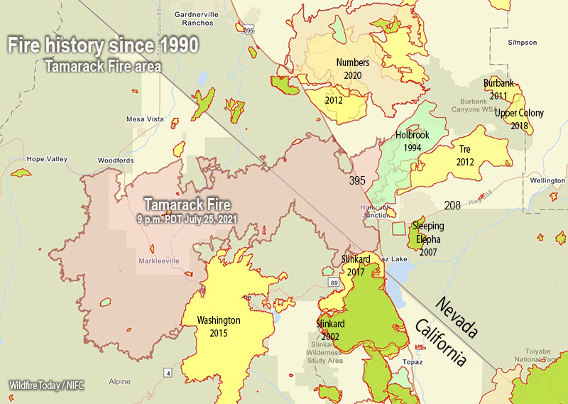
The fire history map above shows that the Tamarack Fire burned into the footprints of multiple fires from previous years, including Washington (2015), Slinkard (2017), Holbrook (1994), and possibly Tre (2012). Not shown on the map is the East Fork Fire that burned in the notch in the perimeter east of Woodfords a few weeks before the Tamarack Fire. Depending on the vegetation type and the recency of the earlier burn, a new fire will usually slow down when it encounters a fire footprint, exhibiting less resistance to control. If it is not too windy, a combination of aerial and ground-based firefighters can often be effective in slowing or stopping the spread in those areas.

The National Situation Report indicates that 15 structures have burned. A map is available showing the location of destroyed and damaged structures.
Hand crews were able to complete containment of the northern edge and several other critical locations on the fire Sunday. Monday’s priorities include finishing containment on the northeast corner and securing more of the southern edge.
Thunderstorms are in the forecast Monday afternoon, and there is a chance for rain into the evening.


The fire history map is interesting. Admittedly, I am ignorant regarding wildfire behavior but it looks like the fire footprint from the Holbrook Fire in 1994 may have helped slow down the current Tamarack Fire. This morning I read about a flash flood warning (?) in the area of the Tamarack Fire, from a local media source?