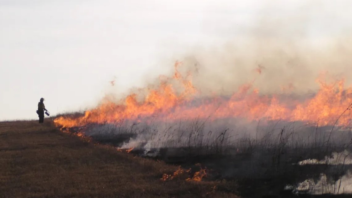
Oregon, Washington, and California legislators have reintroduced a bill poised to create a national prescribed burn collaborative program and increase the practice nationwide.
Oregon Senator Ron Wyden reintroduced the National Prescribed Fire Act of 2024 [PDF] on Tuesday, three years after the act’s first attempt died in committee. Representative Kim Schrier of Washington, Representative David Valadao of California, and Senator Alex Padilla of California joined the act’s push.
The act would invest $300 million in hazardous fuels management and increase prescribed burn plans, preparations, and practices through both the USFS and DOI. The funds are required to be used to develop a prescribed burn strategy for each USFS or BLM region, implement prescribed fires on federal land, and fund an increase in prescribed burn crew staffing.
2013 RxFire at Indiana Dunes National Lakeshore near Ogden Dunes, northwest Indiana — NPS photo
It would also put $10 million toward the collaborative prescribed burn program based on the previous USFS Collaborative Forest Landscape Restoration Program (CFLRP). The previous program, one of the first national efforts that encouraged collaborative landscape restoration, ran from 2009 to 2019 and focused on reducing wildfire risk, enhancing watershed health, and benefiting local rural economies. The program reported its results to Congress, saying it successfully restored 5.7 million acres of forest while creating nearly $2 billion in local labor income.
The 2024 act has the support of numerous conservation agencies and fire officials, including The Nature Conservancy, which has been conducting Rx burns in Oregon since 1983.
“Prescribed fire is an essential tool to restore and steward fire-dependent ecosystems, reduce the risk of extreme wildfire to communities, and help many of Oregon’s most iconic natural landscapes adapt in the face of climate change,” said Katie Sauerbrey, Oregon fire program director at The Nature Conservancy. “We are grateful for Senator Wyden’s leadership on the National Prescribed Fire Act — providing a pathway to accelerate the pace and scale of prescribed fire necessary to combat the wildfire crisis in the western United States.”
Oregon, Washington, and California legislators have reintroduced a bill poised to create a national prescribed burn collaborative program and increase the practice nationwide.
French Jesuit priest Louis Vivier in 1750 described what 70 years later became the state of Missouri, and in his writings he told of Native Americans there setting fires to the prairies. “The trees are almost as thinly scattered as in our public promenades,” he wrote, and “the Savages set fire to the prairies toward the end of the autumn, when the grass is dry; the fire spreads everywhere and destroys most of the young trees.”
Vivier was right about fire being a frequent occurrence in Missouri, as reported in a feature story on KSDK.com. Midwest tribes had been purposely setting fire to the grasslands and prairies for centuries. They recognized the essential role fire played in the prairie ecosystem, and that knowledge, and the practice of managed burns, is being rekindled by the Missouri Prescribed Fire Council, a coalition of landowners and experts attempting to bring the state’s grasslands back to their once-thriving status.
PHOTO: Missouri Prescribed Fire Council
These practices have been recorded nationwide as the philosophy of fire as medicine, according to the National Park Service.
European colonists’ response to the tradition of cultural burning was the implementation of a century-long fire suppression regime. Missouri’s disappearing prairies in part have the resultant lack of fire to blame. Unregulated tree growth, known as woody plant encroachment into tallgrass prairie environments, has progressed throughout the Midwest as areas of saplings develop without needed periodic fire.
Missouri’s Ozark region, for instance, has existed in the “not enough fire” category for much of recent history, causing a drop in biodiversity and the domination of the landscape by oak, hickory, and cedar trees, according to the University of Washington and others.
The Missouri Prescribed Fire Council, though, is trying to reverse that suppression regime and reintroduce managed burns back into the state for the health of its natural environment.
“Almost all of Missouri’s natural plant communities have adapted with fire,” said Wes Buchheit, councilmember and prescribed fire coordinator biologist with Pheasants Forever & Quail Forever. “Fire is a natural tool and prescribed fire is mimicking that natural process in a more controlled setting … you can benefit a lot of different species, plant and animal, with prescribed fire.”
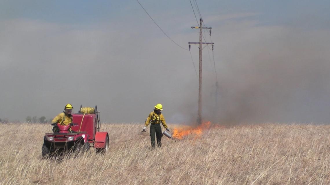
About 93 percent of Missouri’s 44.6 million acres is privately owned, according to the Missouri Department of Conservation. The lack of public land means any substantive prescribed burning must come through community collaboration. In response to multiple recent historic wildfire seasons, a movement of Prescribed Burn Associations (PBAs) has grown nationwide. Many RxFire efforts are led by federal agencies, but these PBAs are instead a collaboration among landowners. The Missouri Prescribed Fire Council is part of that growing movement, and because wildfires haven’t been a prevalent issue for Missourians, private landowners in the state haven’t been as hesitant to participate in prescribed burning as other wildfire-prone states.
Prescribed fires have burned tens of thousands of acres in 95 of Missouri’s 114 counties between 2020 and 2022, council data showed. Of those, just over 1 percent have escaped control, and most burned just 0.1 acres or less, which is on par with national averages. “The only time that folks ever heard about prescribed fire is when there’s an ‘oops,'” says Council Chair Mark Howell. “They don’t hear about the other almost 99 percent of the time that things go perfectly well.”
A fire-focused NPR article had a concise central theme: Trees are not always good, fire is not always bad, and prescribed burning can bring a community together.
The article, written and beautifully photographed in 2022 by journalist Andria Hautamaki, told the story of the Loess Canyon Rangeland Alliance to paint a larger picture of the quick growth prescribed burn associations (PBAs) have had across the country, particularly in states without huge extents of government-owned land.
The Great Plains Fire Science Exchange estimated in 2022 that there were 113 PBAs throughout the United States. That exchange now estimates 135 PBAs, an 83 percent increase in under two years.
Plants flourish after a prescribed fire. Image courtesy Florida Panther National Wildlife Refuge.
PBAs got their start in California and are now found throughout the state. Despite this, California is an outlier in the average states with PBAs: nearly half of California’s land is federally owned. Other states with numerous PBAs (including Nebraska, Oklahoma, and Texas) have less than 2 percent of their land owned by the federal government.
Instead of the USFS burning on federal land, stakeholders in non-West states must convince and collaborate with landowners to spread the gospel of prescribed fire.
“The only way you’re ever going to get fire on the ground is through the landowners, especially in states with a lot of private land,” John Weir, an Oklahoma State University extension specialist for prescribed fire, told Hautamaki during the story. “This is landowner helping landowner. Agencies are important; they help provide technical assistance. But it’s all about grassroots. Landowners can burn safely and effectively because they’re out there managing their own land.”
An abundance of privately owned land isn’t the only thing driving PBA popularity in non-West states. The negative perception fire has gained from numerous disastrous wildfires in recent years has hampered Rx burn efforts in the West. Midwest and Southern states, which don’t have that same negative association with burning, have seen a rise in a grassroots-led fire efforts rather than an agency push.
Previous data have also shown the community-prescribed fire drive to be safe and effective in overcoming common burn limitations related to expertise, equipment, and personnel. A 2012 survey of PBAs found the majority were effective at developing burn plans, working within burn windows, and limiting liability.
“The safety record of PBAs indicates they provide a safe and viable option for landowners and managers who use or would like to use prescribed fire on their lands,” the survey said.
Aerial images from Hutchinson County, Texas shot with a drone yesterday show the aftermath of a huge fire adjacent to a 7-mile swath of land that was prescription burned a few months ago near Borger, a Panhandle town of about 12,000 in north Texas.
Borger, Texas, on Wednesday. Photo by City of Borger / Hutchinson County Office of Emergency Management.15:08 CST 02/29
Northeast of there, the Smokehouse Creek Fire, the largest of at least five other active fires in the Panhandle, has burned over 1 million acres, leaving charred homes and buildings behind. The fire’s doubled in size since 03:00 CST on 02/28.
The drone images in a CNN report feature a 7-mile prescribed burn that was conducted a few months ago.
Officials with Borger’s Office of Emergency Management said the prescribed burn prevented a fire flank from spreading into the southern parts of the town, including the Meadowlark, Country Club, and Bunavista areas.
“As much damage as we have, our proactive efforts did prevent even more,” Hutchinson County officials said. — [Panhandle fires photo gallery]
The fires in Texas and Oklahoma have burned so much land that the blackened ground is visible from space. Satellite imagery captured burn scars stretching from the Texas Panhandle into western Oklahoma Wednesday afternoon.
Satellite shots show burn scars in the Texas Panhandle in the wake of devastating fires. CIRA/RAMMB images.
Burn scars are often a combination of burned vegetation, debris, and a scorched layer of soil. In the satellite image above, the burn scar appears as charcoal gray and black against the tan unburned ground around it.
~ Thanks and a tip of the hardhat to Chris and Alison.
Inside the Homestead Conference Hall at Sunriver Resort in central Oregon last week, six Native Americans sang, danced, and drummed with volume enough to rattle windows. The powerful performance by the Mountain Top Singers of the Paiute-Shoshone Tribe kicked off two days of panel discussions, networking events, and cultural celebration for tribal and nontribal guests at a Lomakatsi fire learning summit.
Leaders and youth representatives from 17 tribes in the Pacific Northwest were involved in the event, according to a Bend Bulletin report. Participants focused on improving ecological health of Pacific Northwest forests, mainly with the knowledgeable and responsible use of fire.
For more than a century, immediate suppression of wildfire was the go-to solution enacted by the Forest Service and other agencies after lightning ignitions or human-caused starts. Wildland officials and scientists now agree that over-suppression has caused forest health to decline and has set the stage for the megafires that now rage across the West, killing humans and destroying homes and burning huge swaths of land from Mexico to northern Canada.
Jefferson Public Radio recently reported that even people who disagree vehemently about the details of the best ways to manage forests can always find some ground on managing wildlands to be more fire resilient.
The Lomakatsi Restoration Project’s Tribal Ecological Forestry Training Program focuses on collaboration with tribes and tribal communities through ecological restoration initiatives. The Program is heavily involved in the restoration work required to make forests fire resilient, using both modern technology and Traditional Ecological Knowledge (TEK) from the region’s tribes, who for millennia used fire to manage the forests where they lived.
Lomakatsi film: Tribal Hands on the Land
Lomakatsi Founder and Executive Director Marko Bey and Tribal Partnerships Director Belinda Brown talked to Jefferson Public Radio about training and a film about it, and their expanding efforts to bring more indigenous people into the fold. Lomakatsi welcomes a new cohort of young tribal adults this fall, and is especially grateful to videographer Ammon Cluff for bringing this video to life.
Crew members also contributed to collaborative landscape-scale restoration projects across southern Oregon, including the West Bear All-Lands Restoration Project, Rogue Forest Restoration Initiative, Ashland Forest Resiliency Stewardship Project, and post-fire restoration Bear Creek, as part of the Ashland Creek Ponds Riparian and Ecocultural Restoration Project.
Lomakatsi operates programs across the ancestral lands of aboriginal peoples who lived and live in the watersheds of the Willamette River, Rogue River, Klamath River, Umpqua River, and Pit River, in what is now called Oregon and California.From sagebrush hillsides and mixed conifer forests, to oak woodlands and riverine systems, they offer respect, recognition, and gratitude to the past, present, and future inhabitants of these landscapes, to whom they dedicate this work.
“Tribes have for time immemorial carefully managed these landscapes with carefully applied fire, with Indigenous practices. The agencies have a real interest in that at this time,” said Marko Bey, founder and executive director of Lomakatsi, the nonprofit group that organized the event in Sunriver.
Bey said the summit was an opportunity to bring tribal members together to share different skills, traditions, and adaptive management strategies. He believes that tribes can play a central role in national management of forest health.
Representatives from all nine federally recognized tribes of Oregon attended the summit. Eight additional tribes with ancestral lands in and adjacent to Oregon were also present.
Myra Johnson-Orange, 74, an elder from the Confederated Tribes of the Warm Springs, said she was pleased the conference brought together Native and non-Native people for joint learning panels.
“Sometimes, non-Native people need to understand better where we are coming from as Native people,” she said, “and how we understand the land and how we have taken care of it since time immemorial. We learn from agencies, but they are learning from Natives, too, how we need to be considered and consulted.”
Lomakatsi operates programs across the ancestral lands of aboriginal peoples who lived and live in the watersheds of the Willamette River, Rogue River, Klamath River, Umpqua River, and Pit River, in what is now called Oregon and California. From sagebrush hillsides and mixed conifer forests, to oak woodlands and riverine systems, they offer respect, recognition, and gratitude to the past, present, and future inhabitants of these landscapes, to whom they dedicate this work.
A Nachusa fire crew hit a 24-acre project area of the grassland Tuesday, November 14, for a prescribed burn on the prairie habitat. Fire has historically been an important and natural part of the prairie; clearing the ground cover stimulates new growth, and many native plants rely on wildland fire to open seed pods and regenerate. Sauk Valley Media sent their ace photographer to track the 10-person crew at Nachusa Grasslands as they worked to put in firebreaks, put down a water line, and ignite the grasses so the fire will burn in their planned direction.
Conditions were just right for a prescribed fire on November 14 at Nachusa Grasslands in northern Illinois. Fire managers hope to do another burn at the end of the week. Photo courtesy Alex T. Paschal.
The 4,100-acre Nachusa Grasslands preserve consists of large remnant prairie, woodlands, and wetlands reconnected through habitat restoration to create one of the largest and most biologically diverse grasslands in Illinois. Including 4,000 acres of restored and remnant prairie, Nachusa Grasslands is home to 180 species of birds, more than 700 native plant species, and a herd of bison.
The Nature Conservancy purchased the core of the preserve in 1986, recognizing that Nachusa offered a terrific opportunity to restore a diverse native grassland.
Working hand-in-hand with Nature Conservancy staff, volunteer stewards collect and plant seeds, manage invasive species, repair wetlands, and conduct prescribed burns to preserve this ecosystem.
The Friends of Nachusa Grasslands has a calendar online for its volunteer workdays; hunting season is scheduled in early December and the spring RxFire season will start up in March 2024. If you’re interested in volunteer opportunities, most workdays are scheduled on Thursday and Saturdays.
The Nachusa Grasslands and its visitor center are south of Rockford, Illinois and about a 2-hour drive west of Chicago.
Originally part of the herd from Wind Cave National Park in South Dakota, these bison have been tested and show no traces of cattle genes. No hiking is permitted inside the fenced North or South Bison Units.
The bison and the grassland vegetation species all benefit from prescribed fire and the Nature Conservancy’s fire research, and this fire — like others at the Grasslands — was timed for weather and fuels conditions that would be conducive to a controllable prescription burn.
“Wind and dry air is what determines whether we can have a burn,” Nachusa Director Bill Kleiman on Tuesday told photographer Alex Paschal.
A light south wind pushed the flames and smoke north, so crews planned for locations of the firebreaks and road warnings for motorists traveling the area. The burn was roughly an “L” shape on Carthage Road, and two separate crew units started the process on either side — so the fire could burn together in the middle.
“If the side upwind doesn’t have enough of a firebreak,” Kleiman said, “it can jump it and burn the other side.”
Alex Paschal has a photo gallery from the burn [HERE].