Recommendations for change: the way ahead for a fire-literate and fire-adapted Europe

A prescribed burn in a maritime pine stand in central Portugal at the Malcata Nature Area in 2010. Photo by Tiago Oliveira.

By Tiago Oliveira

A new era of wildfire mitigation and prevention in the European Union has been defined by two new wide-ranging reports, with the added support of a new global agreement with similar objectives.

• A report by the European Academies Science Advisory Board presented in Brussels on May 19 calls for an integrated European Union framework for landscape fire risk governance and the prioritisation of prevention.

Changing Wildfires – Policy Options for a Fire-literate and Fire-adapted Europe

• The European Academies report followed the publication in April of a proposal by Firelogue – a coalition of research projects – for an integrated wildfire risk management strategy.

View the United Nations global fire management hub initiative

• And on June 17, G7 leaders and guests meeting in Canada signed the Kananaskis Wildfire Charter, endorsing that nations adopt a whole-of-society approach to wildland fire, focus on prevention, leverage research, and build shared capacity to mitigate and respond.

[This article is published in Wildfire magazine. Read more wildfire news and articles here.]

The European Academies report, Changing Wildfires: Policy Options for a Fire-Literate and Fire-adapted Europe, synthesises state-of-the-art fire science and argues that forest ecosystems and European citizens will be exposed soon to a growing wildfire risk. The report recommends the articulation of policies, actively managing forests, and educating and engaging communities.

Already wildfires in the European Union burn, on average, half a million hectares yearly – almost twice the size of Luxembourg. In 2025, almost 1 million hectares burned.

Worked on by 23 scientists nominated by their respective national science academies, the report highlights the complex drivers behind the surge in wildfire risk.

Amplified by climate change, the drivers tie down to rural depopulation and land use changes. As droughts and declining summer rainfall are predicted to double the fire hazard by 2100, rural abandonment of farmland and unmanaged vegetation growth have created vast landscapes of flammable biomass.

The report notes the firefighting trap or paradox – the over-reliance on fire suppression rather than fuels and land management exacerbates future fires – argues that fire suppression alone is not sufficient, and questions the efficacy of EU policies for their overwhelming focus on fire suppression and emergency response.

The report presents European political bodies with eight recommendations:

1. Invest in integrated wildfire risk reduction, including prescribed burning and fuel management.

2. Implement nature-based solutions such as grazing and native species reforestation.

3. Embrace the role of fire allowing planned burns to maintain ecological balance.

4. Invest in education and communication to increase “fire literacy” and preparedness.

5. Invest in landscape management to reduce vulnerability, design and maintain resilient landscape that reduces wildfire risks.

6. Harmonise sectoral policies across agriculture, environment, and urban development to reduce conflicts and risks.

7. Promote compact urban development to limit wildland-urban interface expansion.

8. Encourage sustainable private land management to help landowners adopt fire resilient practices.

While the Mediterranean remains Europe’s highest-risk region, the report warns that a continental fire crisis is brewing, and Alpine and Boreal regions must also prepare for a new era of fire.

“The changing regime with larger, more intense blazes is driven not only by weather, but also by structural socio-ecological shifts,” said Orsolya Valkó, co-chair of the European Academies’ Science Advisory Council’s wildfires working group, in a statement in May.

“Many new areas, such as Central Europe and rapidly warming mountainous areas, will probably be exposed to severe fire weather. This marks a fundamental shift with major consequences for environmental and public safety.”

Firelogue – the coalition of research projects – supports wider calls for an integrated European wildfire risk management strategy.

“Following the example of Portugal, we propose that the creation of a strategy should include some key elements such as the creation of an Inter-agency at the EU level, to work transversally with the various agencies and European Commission directorates (DGs) to operationalise the implementation of inter-agency articulation and coordination, to avoid overlaps and gaps,” the Firelogue report says.

“Also, several of the measures proposed in this document concern the activities of some of these agencies including, for example [Directorate-General Environment, Directorate-General Climate, Directorate General European Civil Protection and Humanitarian Aid Operations, Directorate-General for Agriculture and Rural Development, Directorate-General for Structural Reform Support]. In line with this, we also advocate the implementation of a European Wildfire Management Directive as a regulatory framework to guide wildfire risk management activities.”

Building a handtool fire line and checking its effectiveness in Northen Portugal in 2016. Photo: Tiago Oliveira

The Kananaskis Wildfire Charter means that G7 nations –Canada, France, Germany, Italy, Japan, the United Kingdom and the United States – in addition to guest participants Australia, Mexico, India, the Republic of Korea, and South Africa, will move to integrated fire management and high hopes expressed by the G7 for the United Nations Global Fire Management Hub initiative, which is expected to play a pivotal role in fire-era diplomacy.

For the European Union in particular, the way forward is about interoperability, incident command system-based qualifications, common procedures and operational standards, and also the use of knowledge and science to better determine expansion of fire use as a tool in sustainable forest management, nature-based solutions, and Indigenous land management practices including cultural fire risk reduction measures around communities, buildings, and Infrastructure”

To be fire-literate and fire-adapted in Europe, as recommended in the May 19 report, challenges institutions and politicians. The 2023 Landscape Fire Governance Framework, which brings together governments, businesses, academia, and members of civil society to develop and implement balanced and technically supported solutions to landscape fire management, might be helpful for European institutions and decision makers to improve cooperation among civil protection and forest and conservation agendas and organizations, assuring that the pursued objectives are tackled and best practices are adopted.

Tiago Oliveira
Tiago Oliveira

Tiago Oliveira is a PhD and forest engineer with 30 years of experience in national and international activities specialized in the topics of wildland fire risk management and governance. Oliveria was appointed by the prime minister in the aftermath of the 2017 wildfire season to lead the creation of the Integrated Rural Fire Management System in Portugal. He has been chairman of the board of the Portuguese Agency for Integrated Rural Fire Management since January 2019 and is the former head of the Department of Innovation and Forestry Development (2016-2017) at The Navigator Company. Oliveria was head of forest protection, responsible for fire prevention and suppression operational programs and R&D projects, from 2008 to 2016. Oliveria is has been a member of the IAWF board since 2023.

Two medium engines from a private wildland firefighting company, holding a line during the 2015 fire season near Porto in Portugal. Photo: Tiago Oliveira
Related Wildfire Today article Global wildfire cooperation agreement signed by G7 nations

Wildfire extremes are getting more extreme worldwide, new report shows

BC Wildfire Service

Wildfires across the globe are worsening due to the climate crisis, according to a newly released report compiled by scientists from more than 60 institutes in 20 countries.

The State of Wildfires Report for 2024-2025 found that some of the largest and most catastrophic wildfires over the past year were two to three times more likely to burn due to climate change. The worldwide increases in burned area and fire severity were driven not just by warmer-than-average temperatures, but also by abnormal increases in downpours followed by drought conditions, which boosted dry fuel loads.

“Drought and heatwaves set the stage for four of the most prominent extreme wildfire events of the 2024-25 fire season, including southern California (January 2025), Northeast Amazonia (early in 2024), the Brazilian Pantanal and Bolivian Chiquitano (August-September 2024), and the Congo Basin (July 2024),” the researcher’s report said. “A number of exacerbating factors were present in southern California, including unusually high fuel build-up during previous wet years and unseasonal heat and drought conditions in winter, which coincided with the timing of Santa Ana winds.”

Wildfires that burned between 2024 and 2025 also emitted over 8 billion tonnes of CO₂. The total is a 10% increase in average wildfire emissions since 2003 and exceeds the annual CO₂ emissions of more than 200 countries. South American forests and wetlands had over triple the global emission average, while Canada’s boreal forests emitted double the global average.

The researchers emphasized that greenhouse gas emissions from the burning of fossil fuels will continue to worsen heatwaves and droughts and increase the risk of more frequent and intense fires worldwide, but also said it’s not too late to change the world’s course. They pointed to the upcoming United Nations annual climate summit, COP30, as a venue where developed nations could commit to rapidly reducing their greenhouse gas emissions.

“We need stronger and faster climate action to cut fossil fuel emissions, protect nature and reduce land clearing,” report researcher Dr Hamish Clarke from the University of Melbourne said in an article in The Conversation. “And we can get better at responding to the risk of fires, from nuanced forest management to preparing households and short and long-term disaster recovery.”

Click here to read the full report.

LA’s Palisades Fire caused over $50B in home damages, report finds

A Redfin analysis based on data from the Los Angeles City Council found January’s historic Palisades Fire caused $51.7 billion worth of damage.

The fire damaged roughly 11,000 residential properties, most of which were single-family homes, according to the analysis. The analysis does not include the financial damages caused by the Eaton Fire that burned through Altadena.

“The council shared a list of 11,125 residential parcels in the city of Los Angeles that were inspected by the Los Angeles Department of Building and Safety after the wildfires,” the company said. “Redfin was able to match nearly 11,000 of those parcels with Redfin property value estimates as of December 2024—the month before the fires. Many, but not all, were completely destroyed by the fires.”

The typical impacted home had a value of $3.7 million before the fires, with nearly 100 properties valued at over $20 million. Other similarities shared by impacted properties include having a construction date of 1957, having 2,916 finished square feet, and having a First Street Fire Factor risk score of 5, or “major.”

The Palisades Fire ignited near Skull Rock in the Summit neighborhood at 10:30am, when gusts were reaching up to 60 mph, relative humidity was falling, and severe Santa Ana winds created a highly volatile environment for rapid fire spread, according to a timeline published in April. The fire quickly spread downhill and eastward, spreading 771 acres in 4 hours, 2,920 acres in 8 hours, and 15,832 acres in nearly 27 hours, which accounted for 70% of the fire’s total growth, despite it going on to burn for 43 more days. The Palisades Fire was fully contained on February 20 after burning over 23,000 acres, destroying 6,833 structures, and claiming 12 lives.

PREVIOUS COVERAGE: Timeline of LA’s historic wildfires outlined in new report

“A lot of people who lost their homes are renting while they work through the insurance claim process, and haven’t figured out whether, when or where they’ll buy again,” LA Redfin Premier real estate agent Greg Eubanks said in the analysis. “Some people whose homes burned in the Palisades have put their vacant lots up for sale, but those aren’t selling as quickly as the lots in Altadena because the price point in the Palisades is so much higher, which is a barrier for investors. It’s also a bit of a tough sell because infrastructure hasn’t been rebuilt yet—there are still no grocery stores.”

Misinformation linking Canadian wildfires to arson are part of a long trend, reports find

WildFireSat

The spread of false claims linking Canada’s wildfires to arson or governmental conspiracies, rather than climate change, has been part of a years-long trend, the Climate Action Against Disinformation organization said in a recent bulletin. It said this year’s misinformation is made up of the same baseless claims it detailed in a report from last year.

“Over time, the claims became more conspiratorial, insinuating that left-wing extremists and the Canadian government were responsible for starting the fires,” the report said. “Despite civil society groups’ attempts to debunk this disinformation, false and misleading posts still gained considerable engagement.”

A widespread misinformation campaign blaming Canada’s wildfires on arson and mismanagement has continued, with some help from Republicans in the United States.

Multiple rapid attribution analyses have since shown the direct link between Canada’s wildfires and climate change. Imperial College London’s World Weather Attribution issued a recent briefing stressing that temperatures well above long-term averages increased the likelihood and severity of the fires. The Climate Central nonprofit, in an analysis, found fossil fuel burning made temperatures at least five times higher. The EU-based ClimaMeter organization found that human-caused climate change intensified both high temperatures and winds.

The baseless arson claims continue to gain traction, even with lawmakers from the United States. Multiple Republican lawmakers from Wisconsin and Minnesota recently continued the arson blame game and accused Canada of having poor forest management, saying their constituents are suffering because of it. The letter made no mention of climate change.

It’s not just wildfires in Canada that are seeing more disinformation. Research from the Center for Countering Digital Hate found that Facebook, Twitter, and YouTube enable and profit from conspiracies relating to extreme weather, including the recent Texas floods.

“While families mourned and first responders combed through wreckage after climate disasters in Texas and California, social media companies shamelessly exploited these catastrophes for profit,” the organization’s CEO said. “The rapid spread of climate conspiracies online isn’t accidental, it’s baked into a business model that profits from outrage and division. LA County officials told me that after the fires earlier this year, scammers placed social media ads impersonating federal emergency aid agencies to steal victims’ personal information. When distraught people can’t distinguish real help from online deception, platforms become complicit in the suffering of innocent people.”

Click here to read the full report.

California Counties Most Susceptible to Wildfires

Madre Fire July 5, 2025


As California’s Madre fire continues to grow, becoming the largest in that state in a year already synonymous with wildfire, Wildfire Today guest writer Jackson Ruby looks at Federal Emergency Management Agency (FEMA) data on wildfire risk in California.


From sandy beaches to snow-capped mountains to deserts, California has it all. With its natural beauty and fourth-largest economy in the world, it isn’t surprising that the Golden State has some of the most sought-after and most expensive real estate in the United States.

Despite all that makes California a desirable place to live, an underlying threat makes its presence known every year in the form of wildfire. In 2025 alone, there have been more than 3,200 wildfires, over 96,000 acres burned, and 16,000 structures destroyed. Here, we investigate which California counties are the most susceptible to fires and provide important information to keep your family and home safe.

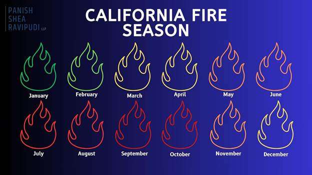
When is California’s “Fire Season”?

As thoroughly explained in an online guide from the Western Fire Chiefs Association, California fires can technically happen year-round, but peak fire season varies by region. In Northern California, it typically starts in June or July and lasts through late October or November. Whereas in Southern California, the peak season begins earlier, in late spring, and can continue through October.

Due to rising temperatures and limited rainfall these destructive firestorms are becoming more and more frequent, with California heading towards a year-round fire season, as with the devastating wildfires in Los Angeles County in January 2025.

California Fires Are Getting Worse

Due to California’s geography and climate, wildfires are not a new phenomenon and would occur regardless of the existence of humans. Yet in recent years, there has been a significant increase in the regularity of record-breaking fires in terms of overall destruction, frequency, and size. 

  • Between 1973 and 2024, the western U.S. saw an average increase of 37 extra “fire weather” days each year, typically marked by high heat, low humidity, and strong winds. This trend is especially severe in California, where these dangerous conditions now happen more often, turning what was once a seasonal threat into a year-round fire risk.
  • In January 2025, Southern California was hit by a string of intense wildfires, including the massive Palisades and Eaton Fires. Together, these blazes destroyed more than 18,000 buildings, took 30 lives, and displaced over 200,000 residents. The Palisades Fire, in particular, ranked as the third-most destructive wildfire ever recorded in the state’s history.
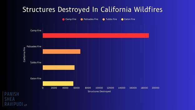
  • According to CAL FIRE, the top four most destructive wildfires in California history have all occurred within the last eight years.
  • Camp Fire (November 2018) 18,804 structures destroyed.
    • Palisades Fire (January 2025) 6,662 structures destroyed.
    • Tubbs Fire: (October 2017) 5,636 structures destroyed.
    • Eaton Fire: (January 2025) 5,418 structures destroyed.
  • Every year, California is confronted with more destructive, record-breaking fires that redefine the danger of California wildfires and demonstrate the dire circumstances many Californians live under. 

California Counties Most At-Risk From Wildfires


Currently, more than 2.3 million acres of land in California is considered to be “high” or “very high” risk for wildfire, with a handful of California counties containing many of these acres within their borders.

Riverside County

  • Based on Cal Fire’s Fire Hazard Severity Zone maps, large portions of Riverside County are rated as “Very High” for wildfire risk. This is increased in regions such as the San Bernardino National Forest, Santa Ana Mountains, and areas around Palm Springs and Temecula.
  • FEMA ranks Riverside County as one of the highest-risk areas for wildfires in California, giving it a maximum risk score of 100%. The county is projected to lose an estimated $319 million each year due to wildfires.
  • Over 70% of structures in Riverside County are at risk of wildfire damage.
  • With an ever-growing population of more than 2.5 million, the risk of wildfires in Riverside County remains a constant danger to the populous.

San Diego County

  • According to updated CAL FIRE maps, San Diego County has seen a 26% increase in areas classified as “Very High Fire Hazard Severity Zones,” growing from about 647,000 to over 871,000 acres. What’s especially concerning is that more urban neighborhoods are now falling within these high-risk zones.
  • Many communities are situated in the Wildland-Urban Interface, where development meets undeveloped wildland, increasing the potential for property damage and loss to wildfires.
  • Several San Diego County cities, including Chula Vista, Del Mar, Carlsbad, Poway, Santee, and San Marcos, have experienced a 10% minimum increase in areas classified as “Very High Fire Hazard.” Poway, in particular, now has nearly 80% of its total land area designated within this most severe fire risk zone.

San Bernardino County

  • With a population exceeding 2 million, many residents live in areas classified under high to very high fire hazard severity zones.
  • Urbanization has led to previously undeveloped high-risk regions being populated, increasing the number of homes and structures at risk.
  • Many cities such as Big Bear Lake, Chino Hills, Colton, Fontana, Hesperia, Rancho Cucamonga, Redlands, Rialto, San Bernardino, Upland, and Yucaipa fall within the very high fire hazard severity zone.
  • Approximately 53% of buildings in San Bernardino are at risk of wildfire, with a high-risk level.
  • San Bernardino experiences increased drought conditions, contributing to heightened wildfire potential.

Los Angeles County

  • In March 2025, CAL FIRE’s updated maps designate extensive areas in Los Angeles County as “Very High Fire Hazard Severity Zones including cities such as Los Angeles, Malibu, Pasadena, Santa Clarita, and Glendale.
  • Los Angeles’ “Very High Fire Hazard Severity Zones” expanded from 646,838 acres in 2011 to 817,212 acres in 2025.
  • Urban expansion into grasslands and timberlands has increased the population now living in the Wildland-Urban Interface (WUI) hazard areas.
  • Areas where wind-blown embers can ignite distant structures now affect approximately 1.3 million structures in Los Angeles County.

Ventura County

  • 88,000 acres in Ventura County fall into the “very high” fire hazard category, a 54% increase from previous years.
  • Many communities in Ventura County are located where urban neighborhoods meet wildland areas, which raises the risk of wildfires threatening homes and critical infrastructure.
  • Almost 80% of buildings in Ventura are vulnerable to wildfires, with a large number falling within high-risk zones.
  • Extended dry periods and below-average rainfall have created perfect conditions for wildfires, turning Ventura County’s fire season almost a year-round risk.

Steps to Take if You Live in a High-Risk Wildfire Area

If you live in an at-risk area for a wildfire, as many Californians do, there are precautions and actions you can take in the event of a wildfire in your area.

Before a Wildfire

  • Regularly clean roofs, gutters, decks, and patios of leaves, pine needles, and other flammable debris.
  • Store gasoline and other flammables in approved containers away from the structure.
  • Attach garden hoses long enough to reach all areas of your property.
  • Keep firefighting tools accessible.
  • Review and update your insurance policies.
  • Videotape your home and possessions periodically for insurance documentation purposes.
  • Create and practice a wildfire evacuation plan, including routes and safety procedures.
  • Keep essential personal items (e.g. passports, birth certificates, photographs, valuable jewelry) in an easy to access location.
  • Build and store accessible emergency supply kits for each member of the household.
  • Remove flammable vegetation and materials within at least 30 feet of your home.

During a Wildfire

  • Stay informed on evacuation orders and the direction of the fire.
  • Gather all essential belongings and emergency kits in preparation for evacuation.
  • Follow a pre-planned evacuation route.
  • Listen and follow the directions of first responders.
  • Be prepared to either drive or evacuate on foot.
  • Secure all pets.
  • Remain calm.

After a Wildfire

  • Only return home when authorities say it’s safe.
  • Inspect your property for structural damage, gas leaks, and electrical issues.
  • Watch for hotspots, ash pits, or weakened trees and structures.
  • Report the damage and start the claims process as soon as possible.
  • Speak to a wildfire attorney

Click here to read the full report.


Understanding circumpolar wildland fire capabilities: Wildfires in the Arctic

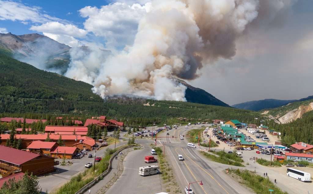
The Riley fire started June 30, 2024, near Denali National Park and Preserve in Alaska. It spread quickly, requiring park staff to evacuate. All photos by Troy Bouffard.

By Troy Bouffard and Edward Soto

The Arctic is undergoing profound environmental shifts, marked by unprecedented warming and ecosystem changes. A critical consequence of this transformation is the rise of extreme wildland fire events across all eight Arctic states, especially the United States (Alaska), Canada, and Russia.

These fires represent a shared northern challenge, transcending borders and impacting everything from carbon release and permafrost degradation to air quality and community safety. While bilateral cooperation on firefighting resources exists, notably between Canada and the United States, a comprehensive, circumpolar platform for collaboration on wildland fire preparedness, mitigation, and response has yet to develop. This gap highlights the need and opportunity for a shared understanding of how each Arctic nation manages wildland fire events.

This article is from a special issue of Wildfire magazine from the International Association of Wildland Fire and the Arctic Council. In this issue scientists, policy experts, community and Indigenous leaders provide clear insights on what is occurring with wildland fire in the Arctic and how best to respond, locally, nationally and internationally.

The Riley fire started June 30, 2024, near Denali National Park and Preserve in Alaska. It spread quickly, requiring park staff to evacuate. All photos by Troy Bouffard.

The Arctic Council Emergency Prevention, Preparedness, and Response (EPPR) Working Group publication, Circumpolar Arctic Wildland Fire Operational Baseline Report, aims to fill this research gap by establishing a foundational understanding of the existing operational capabilities and primary information sources for wildland fire response within each Arctic state.

The report’s value lies in presenting each nation’s operational picture, identifying potential areas for enhanced collaboration, and providing policymakers, operational decision makers, and researchers with the necessary baseline knowledge to engage in further studies and activities. By surveying existing governance operational structures, response systems, information resources, and logistical support mechanisms, the report serves as an important information source toward developing more integrated and effective circumpolar wildland fire management strategies in a rapidly changing Arctic.

OPERATIONAL LANDSCAPES

The report details the diverse approaches each Arctic nations takes toward wildland fire management, reflecting differences in operational governance, geography, and historical fire regimes, which can vary significantly depending on traditional management approaches and risk levels.

CANADA

Wildland fire management primarily falls under provincial and territorial jurisdiction, with the federal government responsible for Parks Canada and military lands. The Canadian Interagency Forest Fire Centre (CIFFC) plays a crucial coordinating role, facilitating resource sharing (personnel, equipment, aircraft) and information exchange both domestically and internationally, particularly with the United States through compact agreements.

By July 7, the Riley fire fire was 31 per cent contained, and evacuation status in the Denali Borough was lifted. The park resumed normal operations but some areas remained closed while crews continued to fight the fire.

Canada uses the Canadian Wildland Fire Information System for predictive services and situational awareness, incorporating data from the Meteorological Services of Canada and the Canadian Forest Fire Danger Rating System. The Canadian Armed Forces may provide support to civil authorities when requested and civilian resources are overwhelmed. Response uses a standardized incident command system, adapted for Canadian use, ensuring interoperability. Resource warehousing is also decentralized at the provincial / territorial level.

THE KINGDOM OF DENMARK (INCLUDING GREENLAND)

Denmark presents a unique structure where both civil and military emergency response capabilities reside under the Ministry of Defence, primarily executed by the Danish Emergency Response Agency (DEMA). Response follows the Emergency Preparedness Act and the National Crisis Management System, adhering to a sectoral principle for assigning responsibilities.

Given Greenland’s vast ice cover and Denmark’s relatively low wildland fire frequency, the focus is largely on an all-hazards approach with a structural fire emphasis. The Danish Meteorological Institute provides weather data, contributing to fire danger indices, often focused on agricultural settings. Response typically starts at the municipal level, escalating to DEMA if needed. Specific wildland fire equipment exists but is integrated within the broader rescue service resources.

FINLAND

The Ministry of the Interior, through its rescue services and regional rescue departments (managed by wellbeing services counties), leads wildland fire response as part of an all hazards mandate under the Rescue Act. The Finnish Defence Forces provide assistance (equipment, personnel, expertise) when requested by civil authorities. The Finnish Meteorological Institute provides essential weather and predictive services, including a forest fire index, which can trigger aerial surveillance flights. Due to intensive forest management, large wildland fires are relatively rare. Resource coordination occurs between wellbeing services counties, with the ministry coordinating international aid. Finland uses the Virve communication network, interoperable with Nordic counterparts via TETRA., the public safety telecommunications network. Training is conducted via the Emergency Services Academy Finland, emphasizing all-hazards response.

ICELAND

Civil authorities, specifically the Department of Civil Protection and Emergency Management under the National Commissioner of the Icelandic Police within the Ministry of Justice, have the sole lead for emergency response. There is no military, though the Icelandic Coast Guard assists in maritime areas and can be involved in suppressing remote wildland fires. The Civil Protection Act provides the framework for an all-hazards response structure from national to municipal levels. Wildland fires have been historically rare due to fuel types, though this may change with climate warming. Consequently, specific wildland fire information sources and specialized training are limited.

The Icelandic Meteorological Office provides general weather forecasting but focuses on more prevalent hazards such as volcanoes and avalanches. Response follows established civil protection plans, resourced locally first, with escalation pathways nationally and through the EU Civil Protection Mechanism.

NORWAY

Responsibility is shared between the Ministry of Justice and Public Security (primary authority via the Directorate for Civil Protection – DSB) and the Ministry of Defence. The DSB provides administrative oversight, while operational response resides with municipal fire and rescue services. The Norwegian Civil Defence and the Armed Forces / Home Guard can provide reinforcement and disaster assistance when needed, forming the total defence concept. Norway uses a unified management system, adapted from the incident command system, but command typically remains at the municipal level. The Norwegian Meteorological Institute collaborates with DSB, utilizing an adapted Canadian Fire Weather Index for risk assessment specific to Norwegian conditions. Resources are primarily municipal, with some national assets such as DSB-administered helicopters available during fire season or high danger periods. Norway also uses European resources such as the Copernicus Emergency Management Service (CEMS) and the Emergency Response Coordination Centre (ERCC).

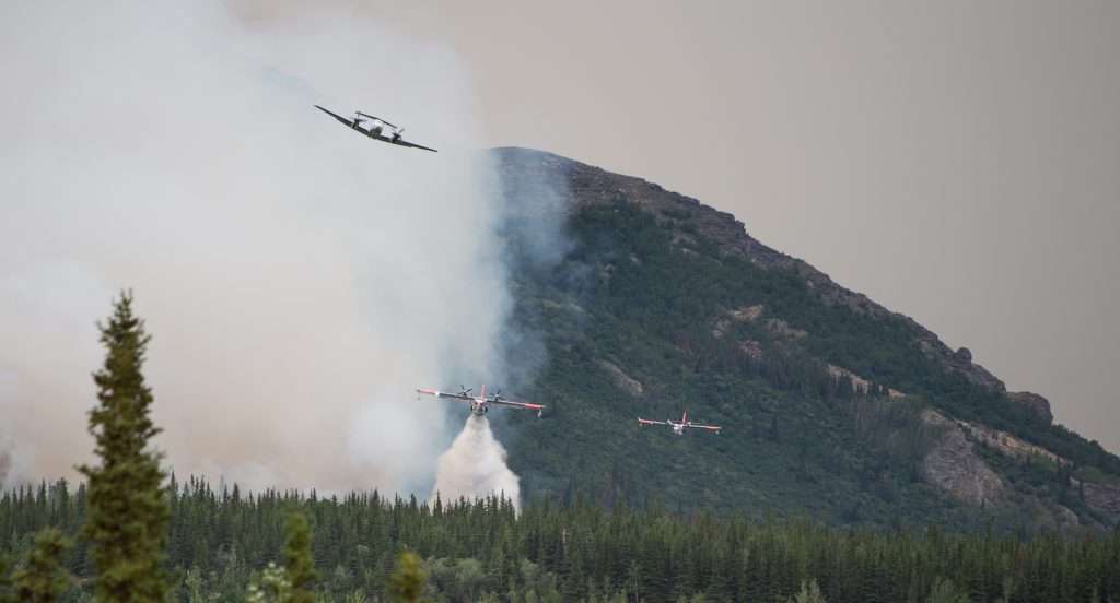
Every aircraft in Alaska that has a tank has been active on this fire today,” Danali Park public information officer Paul Ollig told alaskasnewssource.com on June 30, 2024.
Every aircraft in Alaska that has a tank has been active on this fire today,” Danali Park public information officer Paul Ollig told alaskasnewssource.com on June 30, 2024. Photo Troy Bouffard

THE RUSSIAN FEDERATION

The Federal Forestry Agency (FFA), under the Ministry of Natural Resources and Environment, is the lead agency for wildland fire protection and suppression, operating through territorial authorities. The Forest Code and federal law On Fire Safety define responsibilities, assigning coordination functions to the FFA, which establishes federal and regional headquarters. The Ministry of Emergency Situations, known as EMERCOM, handles fires in populated areas and provides support, while the Ministry of Defense’s Forestry Department manages fires on defense lands. Authority is delegated to the subjects (regions) of the Russian Federation, which develop annual consolidated fire suppression plans detailing resources (personnel, machinery, equipment) from various state, municipal, and other involved entities. The FFA oversees information reliability and coordinates interregional manoeuvring of resources. The Russian government’s Aerial Forest Protection Service (Avialesookhrana) provides specialized aviation resources, including aircraft and parachute firefighters.

SWEDEN

The Swedish Civil Contingencies Agency (MSB), under the Ministry of Defence, holds responsibility for civil protection, public safety, and emergency management, including coordinating and supporting roles in large wildland fires. Operational response is led by municipal fire and rescue departments. Sweden employs a total-defence concept incorporating emergency preparedness and civil defense, involving collaboration among government agencies, municipalities, regions, industry, and NGOs. The Swedish Meteorological and Hydrological Institute provides fire risk assessments using the Canadian Fire Weather Index during the fire season. Response is resourced locally / regionally, with cross-border municipal agreements and support from MSB, which maintains equipment depots and coordinates national / international aviation assets, including rescEU resources hosted in Sweden. If resources become scarce, MSB can prioritize allocation.

THE UNITED STATES

Wildland fire response is characterized by extensive interagency cooperation, coordinated nationally by the National Interagency Fire Center (NIFC). NIFC integrates federal agencies within the departments of agriculture and interior, state forestry agencies, and others under common incident command procedures and safety guidelines. The Department of Defense provides support to civil authorities upon request from NIFC, typically as a surge capability. Information sources are coordinated, with National Oceanic and Atmospheric Administration / National Weather Service providing key weather and predictive services. Firefighter qualifications and operational standards are standardized nationally through the National Wildfire Coordinating Group. Resources (personnel, aviation, equipment, supplies) are managed through interconnected interagency systems – Incident Qualifications and Certification System (IQCS), Interagency Resource Ordering Capability (IROC), National Fire Equipment System (NFES) caches –allowing for efficient mobilization from local to national levels. Unmanned aerial vehicles are increasingly integrated into operations.

CROSS-BORDER COOPERATION: NORDRED, RESCEU AND THE NORDIC REGION

Beyond national capacities, regional cooperation mechanisms significantly enhance response capabilities, particularly in the Nordic region. Nordred facilitates rescue collaboration (information sharing, operations) among Denmark, Finland, Iceland, Norway, and Sweden, supported by agreements at both national and cross-border municipal levels. Additionally, these nations, along with other European countries, participate in the EU Civil Protection Mechanism and its rescEU component, which provides a reserve of resources, including firefighting aircraft, coordinated through the Emergency Response Coordination Centre for international assistance. These frameworks are integral to Nordic preparedness and response culture.

This baseline report illuminates the diverse, yet often complementary approaches Arctic nations employ to manage wildland fires. While significant operational collaboration already exists within subregions such as North America and the Nordic countries, facilitated by shared systems (such as variations of the incident command system), common standards, and established agreements (such as forest fire compacts and Nordred), the frameworks and capabilities are not yet fully interoperable across the entire circumpolar Arctic.

The inventory reveals each Arctic state’s operational governance structures, key information sources (weather, predictive services, geospatial data), response protocols, and resource management systems. This foundational knowledge is crucial for identifying commonalities that can be leveraged for broader cooperation and gaps that require attention and development. As the Arctic continues to warm and wildland fire regimes intensify, understanding these national operational baselines is paramount.

Troy Bouffard, U.S. Army (Ret.), has a master’s degree in Arctic policy and a PhD in Arctic defense and security from the University of Alaska Fairbanks. He is the director of the UAF Center for Arctic Security and Resilience. Bouffard is a research fellow with the United States Military Academy – Modern War Institute. He was also the former Arctic Advisor to U.S. Senator Lisa Murkowski as a congressional fellow.

Edward M. Soto, Col, USAF (Ret.) has a forest engineering degree with a graduate certificate in Arctic securities and currently works as a project manager for the Alaska Division of Forestry. His military service includes two command tours in civil engineering and aircraft maintenance. Soto has also worked as a forest engineer and in wildland fire management throughout Alaska when not in military service.

Triple fatality report finds cabin pressure defect caused lack of oxygen

A timeline of the fatal incident in Queensland in November 2023. (Photo ATSB)

A plane crash that killed three people while conducting a fire surveillance operation in outback Queensland in 2023 was due to the pilot suffering from a severe lack of oxygen caused by a defect in the aircraft, a transport safety report has concluded.

The Australian Transport Safety Bureau report found that the aircraft’s steep descent and ultimate impact with the ground was almost certainly due to the pilot being hypoxic due to a known defect with the aircraft’s pressurisation system.

ATSB Chief Commissioner Angus Mitchell released the report (on 19 June 2025) with the conclusion that the incident should have been prevented. “This was a tragic and entirely unnecessary accident that underscores the dangers of operational practices which circumvent critical safety defences, and the insidious and deadly potential of altitude hypoxia.”

The AGAIR‑operated twin turboprop Gulfstream 695A (a variant of the Aero Commander aircraft series) was mapping fire zones near Mount Isa on 4 November 2023, with a pilot and two camera operators on board, including 22-year-old William Jennings from the United States. The other two people on board the aircraft have not been publicly identified, although the ATSB report states that the pilot had a total of 4900 hours flying experience, including with high-performance Royal Australian Air Force military aircraft. The pilot had only joined AGAIR in August of 2023 and at that time had not previously flown a Gulfstream 695A but subsequently undertook training.

The report found: “Over a period of many months, the accident aircraft’s pressurisation system was not reliably maintaining the required cabin altitude. This led some company pilots to employ a variety of actions in the aircraft to manage the potential and deadly effects of hypoxia, including at times briefly descending to lower altitudes, and improperly using emergency oxygen systems,”.

The ATSB found that the aircraft had a long-term intermittent defect with the pressurisation system that would manifest as a reduced maximum attainable cabin differential pressure. The report noted that the defect was known by senior AGAIR management who attempted to have the defect rectified. However, the ATSB concluded, they did not formally record the defect, communicate it to the safety manager, undertake a formal risk assessment of the issue, or provide explicit procedures to pilots for managing it. 

“The ATSB found the onset of hypoxia during the flight significantly degraded the pilot’s ability to safely operate the aircraft, and it is possible that at stages the pilot also experienced some loss of consciousness,” Mr Mitchell said.

Air traffic control recordings of the pilot’s speech during the accident flight demonstrated significant and progressive impairment, including slowed, stuttering and flat speech, operational mistakes and signs of confusion.

“Hypoxia can occur when an individual is exposed to high altitudes, typically above 10,000 ft, when not enough oxygen is supplied to the blood, tissues and cells for the body and brain to properly function,” Mr Mitchell said.

ATSB has issued a formal safety recommendation to AGAIR to initiate an independent review of its organisational structure and oversight of operational activities to implement ongoing effective operational control by management.

Read the final report: Pilot incapacitation, loss of control and collision with terrain involving Gulfstream 695A, VH-HPY, 55 km south-east of Cloncurry Airport, Queensland on 4 November 2023

Australia braces for unseasonally high wildfire risks

Australian Seasonal Bushfire Outlook Winter 2025

Wildfire experts in Australia are sounding the alarm during a time that has historically been one of relief.

The Australian and New Zealand Council for Fire and Emergency Services, or AFAC, recently released its Seasonal Bushfire Outlook for the region. As winter begins across the southern parts of the nation, the report warns residents of a heightened wildfire risk from June through August, specifically for the southern coastal areas of South Australia and significant portions of western, southwestern, and southeastern Victoria.

The regions with the highest risk also faced the lowest or near-lowest amount of rainfall on record between January and April, according to the Australian Bureau of Meteorology. The lack of rainfall has increased wildfire risk in both grassland and forest areas, but has reduced fire risk in pasture and crop landscapes.

Image: Rainfall deficiencies in the first four months of 2025. Source: Australian Bureau of Meteorology.
Rainfall deficiencies in the first four months of 2025. Source: Australian Bureau of Meteorology.

“The prolonged drought conditions mean that communities across parts of Victoria and South Australia may see more activity than normal for this time of the year,” AFAC CEO Rob Webb said in the Outlook. “Fire authorities will monitor the landscape conditions and climate influences closely this season to manage bushfire risk and identify opportunities for mitigation activities such as planned burning.”

The season is also forecast to be warmer than average nationwide. This, combined with higher-than-average pressure systems and warmer-than-average sea surface temperatures attributed to climate change, caused experts to alert communities to stay vigilant and alert during the usual off-season for wildfires across southern Australia.

Northern Australia’s wildfire risk, however, is low thanks to tropical rainfall activity persisting into the typical start of the dry season – and northern fire season – for the region.

Click here for the Bureau of Meteorology’s winter long-range forecast for each of Australia’s regions.

Timeline of LA’s historic wildfires outlined in new report

What started as a wildland fire quickly catalyzed into a widespread urban wildfire in Los Angeles on Jan. 7. In the wake of the tragedy, researchers are understanding more about just what fueled the conflagration.

A new report from the Insurance Institute for Business & Home Safety outlines the timeline of both the Palisades and Eaton fires. Institute researchers also entered the community in the days following the destruction and uncovered what types of homes were worst-hit by the fires, and which were more fire resistant.

The Palisades Fire ignited near Skull Rock in the Summit neighborhood at 10:30 a.m., when gusts were reaching up to 60 mph, relative humidity was falling, and severe Santa Ana winds created a highly volatile environment for rapid fire spread. The fire quickly spread downhill and eastward, spreading 771 acres in 4 hours, 2,920 acres in 8 hours, and 15,832 acres in nearly 27 hours, which accounted for 70% of the fire’s total growth, despite it going on to burn for 43 more days. The Palisades Fire was fully contained on February 20 after burning over 23,000 acres, destroying 6,833 structures, and claiming 12 lives.

The Eaton Fire ignited in the Eaton Canyon area of the San Gabriel Mountains at around 6:20 p.m., around eight hours after the Palisades Fire began. At that time, peak gusts surpassed 60 mph, sustained winds exceeded 40 mph, and relative humidity had dropped to around 10%, creating extreme fire weather conditions. Just 16 hours after igniting, the fire had grown to over 10,000 acres. Although the fire continued burning for 42 more days, its initial 24-hour growth of over 13,600 acres would be 96% of its final size. The fire was fully contained on Feb. 20 after burning over 14,000 acres, destroying 9,418 structures, and claiming 17 lives.

Flames from burning tightly spaced buildings only worsened the fires’ spread, according to the report. Each home ignition generated short-range and ground-traveling embers, further amplifying the fire, specifically in downtown Altadena and Pacific Palisades. Fire-resistant building materials, however, reduced damage severity and interrupted the chain of conflagration.

Click here to read the full report.

Natural Hazards Research Australia is holding a public webinar on the report at 11:30 a.m. AEST on April 16 (9:30 p.m. ET on April 15). Click here to register.


Massive lead spike in Los Angeles’ air during wildfires, CDC says

Thousands of Los Angeles residents fled their communities in January as the Palisades and Eaton fires neared their homes. While they escaped the dangers of the flames, another danger was spewed into the air, affecting countless other people.

Airborne lead levels in the city were 110 times higher than usual during the wildfires, according to a new report from the Centers for Disease Control and Prevention (CDC). Los Angeles’ “Atmospheric Science and Chemistry mEasurment NeTwork (ASCENT)” (sic) site measured the increase from Jan. 8 to 11, with lead amounts spiking on Jan. 9.

The CDC attributed the increased lead levels to the homes that burned, many of which were built before 1978 when use of leaded paint was still common.

“The presence of heavy metals such as lead is not unusual in urban fire emissions, particularly in California, where legacy pollutants from older infrastructure, industrial sources, and soils can be remobilized during fires,” the CDC’s report said. “For example, during the 2018 Camp fire, monitors recorded ambient PM2.5 lead concentrations that averaged 0.13 μg/m3 during a period of 17 hours.”

The health effects from the lead-heavy emissions won’t be specifically known for some time, but center officials said ASCENT’s real-time measurements of airborne lead and other chemical constituents from the wildfires will be combined with health data of smoke-exposed individuals to gain a better understanding.

Generally, increased lead levels affect nearly every human organ, accumulate in teeth and bones, and pose significant health risks, especially for children who are more vulnerable to the element’s neurodevelopmental effects, the CDC said.

“Measures including removing lead from gasoline and leaded pipes and the banning or limiting of lead in consumer products, such as residential paint, have led to a 97% decrease in airborne lead concentrations in the United States since 1980,” the report said. “However, unlike chronic lead exposure, which has been widely studied, the health effects of brief, elevated lead exposures, such as those described in this report, are not well understood. Additional health research is needed, because airborne lead levels alone do not necessarily indicate exposure.”

Click here to read the full report.