Wildfire briefing, May 21, 2012

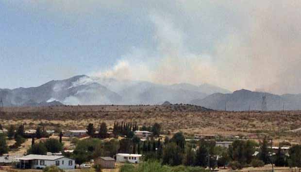
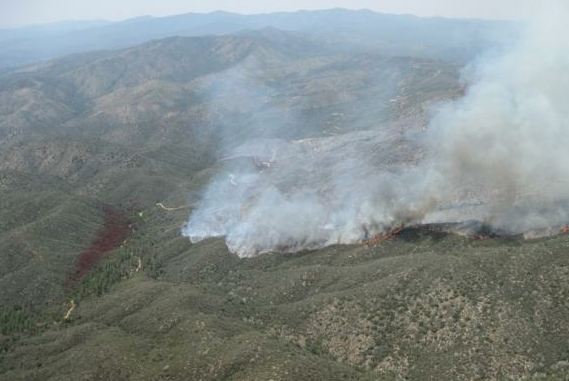
Gladiator fire, May 21, southwest side, photo by Stewart Turner
Southwest side of the Gladiator fire, May 21. Photo by Stewart Turner

Highway 1 fire in Ely, Minnesota was a big friggin’ deal
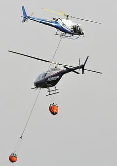
Helicopters on Highway 1 fire
Helicopters shuttle water to the Highway 1 fire, May 17, 2012. Mesabi Daily News, Mark Sauer

Thursday’s Highway 1 fire that burned into the outskirts of Ely, Minnesota was not huge in terms of size, burning 175 acres, but it burned three structures, caused evacuations, and was featured on a BBC program. The National Geographic 24/7 Wild channel was in Ely broadcasting a live program about black bears, when right at the end of the episode the fire broke out. They mentioned it on the air, and when the program ended the crews went to the fire a few miles away and shot some interesting footage which they aired Monday night on 24/7. They tied it in with bears by explaining that when threatened, bears will frequently take refuge in a tree, but the host said that may not be the best tactic when a wildfire is approaching.

An article in the Pioneer Press gave a lot of credit to the local firefighters who placed an engine at nearly every threatened house and did the best they could in the face of the rapidly moving fire pushed by 35 mph winds. The article also credited the aerial resources for helping out significantly with a rapid initial attack response, something that is increasingly rare, at least in the western United States (with the possible exception of CAL FIRE’s S-2 fleet on state-protected lands). Here is an excerpt from the article:

…From the [Superior National Forest] district office, [Kawishiwi District Ranger Mark] Van Every could see three helicopters, including a giant Sikorski Skycrane, dropping water on the fire in an effort to slow its march north into town and keep it away from buildings. The helicopters, on the scene minutes after the fire was reported, had been on call at the Ely airport as part of the regional and national network of forest fire resources.

Just minutes later, the helicopters were joined by the two U.S. Interior Department CL-215 water bombers stationed in Bemidji. Just behind them were two more state of Minnesota CL-215s stationed in Hibbing. Each of the hulking twin-engine amphibians can drop 1,400 gallons of water in seconds, turn around, scoop up water from nearby Shagawa Lake and be back with another load within minutes.

“We had helicopters dropping water on the fire within 15 minutes of getting the call,” Van Every said. “The CL-215s were here within a half-hour or so. … If we hadn’t had those aircraft so close by and ready to fly, I don’t think we could have kept the fire out of Ely.”

Firefighters were very thankful on Saturday when the fire received an inch of rain.

Fire Weather Watch for South Dakota and Wyoming

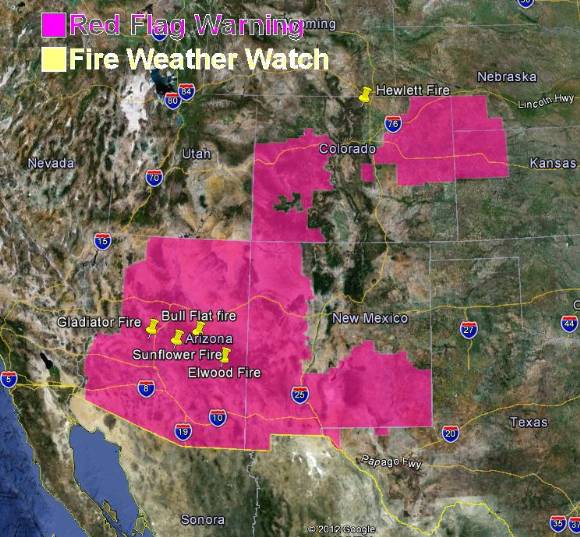
The National Weather Service is calling it a Fire Weather Watch instead of a Red Flag Warning, but the lower elevations of northeastern Wyoming and southwestern South Dakota will have some significant fire weather on Tuesday. Forecasters predict winds of 15 to 25 mph with gusts up to 40 mph, and a relative humidity as low as 12 percent. Just to make things interesting, there is a chance of lightning with very little rain.

UPDATE 8:19 a.m. MT, May 22, 2012: This has been upgraded to a Red Flag Warning. See the map below. And again, this map shows nothing in Utah even though there is a Red Flag Warning for southern Utah for May 22.. The National Weather Service needs to fix this.
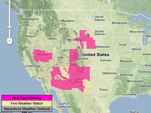
Red Flag warnings 5-22-2012

Thoughts about containment

We have written before about how some Incident Commanders have been misusing the term “containment”, confusing it with “control”. According to the National Wildfire Coordinating Group’s Glossary, when there is a control line around the fire which can reasonably be expected to stop the fire’s spread, it is contained. When I used to work as a Situation Unit Leader, after mapping the fire perimeter, the length of completed fireline, and the open line, I would use math to compute the percentage of fireline that was complete. That became the percent contained. Easy. It was not subjective, complicated, or controversial. It was honest.

In March, for example, there was a fire that was completely lined, but the Incident Commander called it 15% contained. Some IC’s may be scared to call a fire contained, thinking that if additional acres are burned, they will look bad. Or they might be afraid of not receiving the resources they need if the containment figure is between 25 and 100 percent.

If the containment stats given out by incident management teams become meaningless, it will complicate the prioritizing of fires when resources become stretched thin. With budget reductions resulting in fewer firefighters, air tankers, and helicopters, that “stretched thin” threshold has gotten lower and lower in recent years.

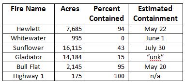
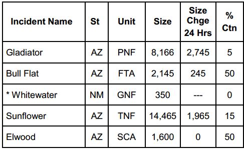
Here are some containment stats found today, May 21, on InciWeb and the NICC National Situation Report. I have no idea if they are accurate. They may be, but the point is, the way the term is being used, we just don’t know anymore.

Containment status of fires

Camper cited for starting Hewlett fire

GavelFrom the U.S. Department of Justice:


===================================================

DEPARTMENT OF JUSTICE NEWS RELEASE

John F. Walsh, United States Attorney, District of Colorado

FOR IMMEDIATE RELEASE

May 18, 2012

FOREST SERVICE ISSUES CITATION TO PERSON RESPONSIBLE FOR HEWLETT GULCH FIRE DENVER – The U.S. Forest Service has issued a citation under 36 CFR Section 261.5 (causing timber, trees, slash, brush or grass to burn except as authorized by permit) to James J. Weber of Fort Collins, Colorado for starting the Hewlitt Gulch Fire. Weber faces a $300 fine plus a $25 processing fee. The Forest Service will also pursue Weber for restitution.

According to U.S. Forest Service investigators, Weber was camping on the Hewlett Gulch trail. While camping he used a camp stove which uses alcohol. On Monday, May 14, 2012, the camp stove Weber was using started the Hewlett Gulch Fire. Weber attempted to stomp out the fire, but was unsuccessful. He fled as the fire spread. Weber later reported that he started the fire to the Larimer County Sheriff’s Office. There is no cell service at the location of the origin of the fire.

Red Flag Warnings portend challenges for firefighters in Arizona

Red Flag Warnings May 18, 2012

A Red Flag Warning always indicates that firefighters could be presented with challenges when trying to control a wildfire under the predicted extreme weather conditions. Today a Red Flag Warning is in effect for most of the state of Arizona including the areas in which several large fires are burning — the Gladiator, Bull Flat, and Sunflower fires. The Warning is in effect in the central Arizona area until 8 p.m. MST Friday evening for strong winds and low relative humidity. The forecast is for southwest winds at 15 to 30 mph with gusts of 35 to 50 mph, and a minimum relative humidity as low as 8 percent.

This could cause the Gladiator fire, which has now burned 9,900 acres, to grow on the north side again on Friday and move closer to the community of Mayer. At 2 a.m. Friday morning MST the Gladiator fire was about 7 miles from Mayer.

As we noted on Thursday, again the entire state of Utah miraculously avoided a Red Flag Warning. Maybe all of their fire weather forecasters are on their days off. Or, the map was created by the staff of the Onion, who previously discovered a wildfire that “raged back into control”.

Gladiator fire, May 17, photo by Michelle Fidler, SWIMT
Gladiator fire, May 17, as seen from Mayer High School. Photo by Michelle Fidler, SWIMT

The weather at 11:53 a.m. MST at the Sunset Point weather station about 7 miles southeast of the Gladiator fire was: 82 degrees, 11 percent RH, winds 14 mph out of the SSW with gusts of 24 mph.

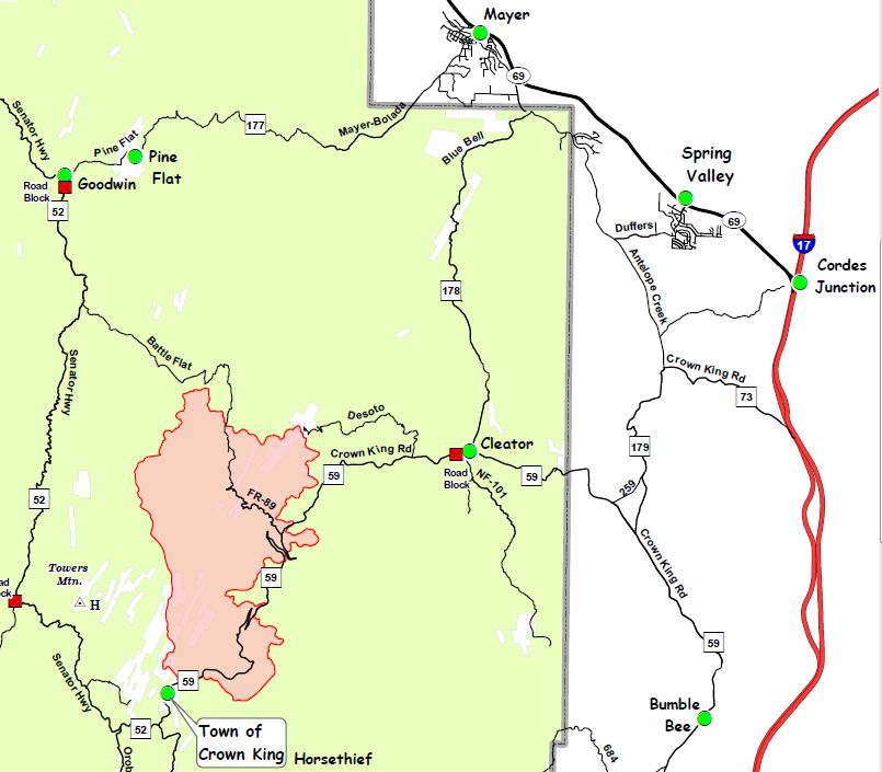
The map below shows the Gladiator fire’s perimeter as of 2 p.m. MST May 17, 2012. The entire map can be seen HERE.

Map Gladiator Fire, 2 p.m. May 17, 2012

The fire has knocked a Prescott television station off the air. The transmitter site for KAZT-TV has not been burned by the fire but the electrical power leading to the site has been interrupted. A backup power generator supplied electrical power to the transmitters for a while, but then it failed. Technicians cannot access the transmission site due to road closures.

Arizona fire stats 5-18-2012
Arizona and New Mexico fire stats 5-18-2012, from NIFC.

Hewlett fire grows to 7,000+ acres

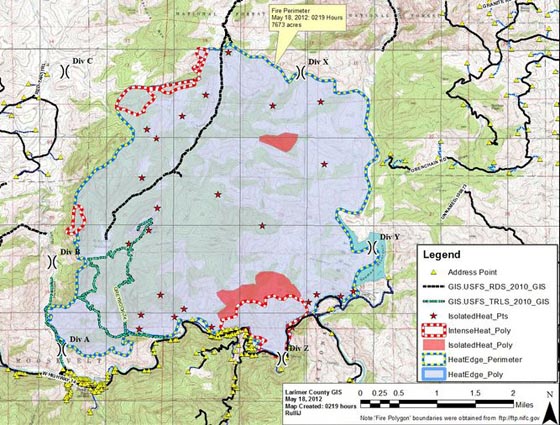
Map of Hewlett fire, 2:19 a.m., May 18, 2012

UPDATE at 8 p.m. May 18, 2012

The US Forest Service announced that all evacuations and Highway 14 reopened at 7 p.m.. There was no fire spread on Friday and it is 45% contained.

====================================================

The Hewlett fire, 10 miles northwest of Fort Collins, Colorado added a couple of thousand acres on Thursday, and at 2 a.m. Friday morning was mapped by US Forest Service infrared aircraft N144Z at 7,673 acres. The map of the fire above shows that the perimeter moved south down to Highway 14 and appears to be holding there, at least for now. If you need a higher resolution version of the map you can view it here; it’s 1.5 MB.

Thursday firefighters conducted some burnouts on the east side that strengthened that flank of the fire along the North Fork of the Poudre from Seaman Reservoir to Long Draw. Portions of Highway 14 remain closed.

Here is some information from InciWeb about evacuations:

The mandatory evacuation for the 15 homes along Highway 14 from the Greyrock Trailhead to the North Poudre diversion dam (approximately mile markers 113 to 115) is still in effect. Highway 14 remain closed from Ted’s Place to Stove Praire. Evacuation Center is established at Cache La Poudre Middle School, 3515 West County Road 54G in La Porte, Colo. If you have large animals, you may take them to The Ranch off of I-25.


Evacuations underway for Hewlett fire in Colorado

Hewlett fire May 16, 2012
Map of the Hewlett fire May 16, 2012. (The time stamp on the fire perimeter shown above is incorrect. The perimeter was mapped by an infrared flight at 10 p.m. May 16.)

UPDATE at 12:54 p.m. MDT, May 17, 2012

The Larimer County Sheriff’s office reported at 12:50 p.m. that Highway 14 has been closed from Ted’s PLace to Stove Prairie Road. Residents may use the road to leave.

=======================================================

At approximately 11 a.m. today the Larimer County Sheriff ordered evacuations in front of the Hewlett fire which has grown substantially over the last 24 hours (see map of the Hewlett fire above). The fire is burning 10 miles northwest of Fort Collins on the north side of Highway 14. On Wednesday the size was reported to be 982 acres, but an infrared imagery flight by US Forest Service aircraft N144Z at 10 p.m. Wednesday night mapped it at  5,090 acres.

Here is the information about the evacuation provided Thursday morning by the Incident Management Team:

The Larimer County Sheriff’s Office has issued a mandatory evacuation order in the area of Bonner Springs Ranch Road, Deer Valley Road, Obenchain Road and Ingleside Road. All residents are asked to evacuate immediately. Evacuation Center is being established at Cache La Poudre Middle School, 3515 West County Road 54G in La Porte, Colo. If you have large animals, you may take them to The Ranch off of I-25.

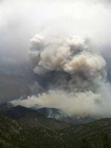
Hewlett fire May 16, 2012 Photo by Amy Cosper
Hewlett fire May 16, 2012. Photo by Amy Cosper

The reload base for the air tanker(s) working the fire is Jeffco (Rocky Mountain Metropolitan Airport) 55 miles south of the fire. On Wednesday there was one air tanker working on the fire, and there is an unconfirmed report that only one is working the fire again today.

The weather forecast for the fire area Thursday afternoon is for northwest winds shifting to southwest at 10 mph, temperature of 83, and relative humidity in the high teens. On Friday the winds will increase substantially at 15 mph hour gusting to 24 out of the south, then southwest.