200 active-duty soldiers activated to fight wildfires in California

Their fire training will begin August 30 near Tacoma, Washington

marines firefighters military
File photo. Robert Baird, Regional Director of Fire and Aviation management in the Pacific Southwest Region of the USFS addresses some of the Marines and Sailors from the 7th Engineer Support Battalion from Camp Pendleton, CA during a welcoming ceremony for Marines at the Creek Fire Incident Command Post on the Sierra National Forest, Saturday 19, 2020. USFS photo.

The National Interagency Fire Center (NIFC) in Boise, Idaho, has requested a Department of Defense (DoD) activation of approximately 200 active-duty U.S. Army Soldiers to assist with wildfire suppression efforts. The National Multi-Agency Coordinating Group (NMAC) at NIFC requested the personnel along with command and support staff. After receiving training, the Soldiers will serve as hand crews, assisting with wildfire suppression efforts in Northern California. Two similar requests were granted last year to support the August Complex and Creek wildfires in California.

The Soldiers will be trained over the next week at Joint Base Lewis-McChord (JBLM) near Tacoma, Washington and on the fireline to provide support in early September in Northern California.

“The United States has been experiencing above-normal fire activity throughout multiple geographic areas, which will likely continue into the fall. These conditions are creating competition for all types of wildland fire resources,” said Josh Simmons, NMAC Chair.

Currently, 84 large fires have burned 2.5 million acres in 9 states. More than 26,000 wildland firefighters are currently assigned to fires across the United States. The country has been at Preparedness Level 5 – the highest level of wildfire preparedness – since July 14. Several geographic areas are experiencing large, complex wildland fire incidents, which have the potential to exhaust national wildland fire suppression resources.

The training at JBLM will consist of both a classroom portion and field training in the basics of wildland fire suppression and firefighter safety. The Soldiers will be outfitted with wildland fire personal protective equipment  and other gear. They will be trained by wildland fire agency personnel beginning Monday, August 30 and should conclude by Wednesday, September 3. While providing support, the Soldiers will be accompanied by experienced wildland fire strike team leaders and crew bosses from wildland fire management agencies.

This is the 40th time since 1987 that active-duty military personnel have been mobilized to serve as wildland firefighters. In addition to the U.S. Army activation, eight U.S. Air Force C-130s equipped with Modular Airborne Fire Fighting Systems (MAFFS) are currently serving as airtankers, providing wildfire support across the West.

She wrote “I love my job” just days before being killed by a bomb in Afghanistan

Nicole Gee
Marine Corps Sgt. Nicole Gee, 23, of Roseville, Calif. posted this photo of herself six days before being killed by a terrorist in a bomb explosion.

Too often on Wildfire Today I have to write about line of duty deaths (LODD) of firefighters. My heart goes out to the families, friends and co-workers of the 13 troops who were killed and the 18 other troops who were wounded in the bombing that killed at least 170 people Thursday near the Kabul airport in Afghanistan.

To firefighters, that disaster would be equivalent to the South Canyon Fire that killed 14 in 1994. It is likely that at least one of those 10 men or 4 women told someone that they loved their job also.

Each of these individual deaths and injuries Thursday is tragic. One of them on the list of names released today by the Pentagon is being noted in particular because of an Instagram post before the attack. Marine Corps Sgt. Nicole Gee, 23, of Roseville, California posted a photo of herself holding an infant six days before she was killed, writing, “I love my job  ?”

The Department of Defense picked up the photo and used it in their Twitter account on the same day with two other photos.

Two days later she posted another photo of her escorting a long line of evacuees as they boarded an airplane to flee Kabul.

Sgt. Nicole Gee
Marine Corps Sgt. Nicole Gee, 23, of Roseville, Calif. posted this photo of herself four days before being killed by a terrorist in a bomb explosion.

Sgt. Gee, a maintenance technician with the 24th Marine Expeditionary Unit, was from Roseville, Calif., Stars & Stripes reported. She was promoted to Sergeant a few weeks before being killed.

At the airport she had been assigned to assist women and girls at the airport as they fled Taliban repression.

Sgt. Nicole Gee
Sgt. Nicole Gee walks with a family during ongoing evacuations at Hamid Karzai International Airport, Kabul, Afghanistan on Aug. 24, 2021. U.S. Marine Corps via AP.

May she rest in peace.

Firefighter dies at brush fire in Spokane County, Washington

Cody Traber firefighter
Cody Traber. Photo on left by Spokane County FD. Photo on right by Robert J. Shaer in 2002.

A firefighter with Spokane County Fire District 9 died while at a brush fire Thursday in Washington.

According to the Spokane County Sheriff’s Office, Mr. Traber fell from the Wandermere Bridge on Interstate 395.

In a Facebook post the Fire District said Mr. Traber was an 18-year veteran of the District and previously served at the Department of Natural Resources and two other fire departments. He leaves behind his wife, Allisyn and four young children.

We send out our sincere condolences to Mr. Traber’s family, friends, and co-workers.

More evacuations ordered for Caldor Fire southwest of Lake Tahoe

149,000 acres have burned

9:36 a.m. PDT August 28, 2021

Caldor Fire map 11 p.m. August 27, 2021
Caldor Fire, mapped by a fixed wing flight at 11 p.m. August 27, 2021. The areas shaded dark red had intense heat during the mapping flight.

The Caldor Fire on Friday spread less than in previous days, but still grew by about 6,000 acres to bring the size up to 149,000 acres.

There was incremental movement on northeast side, less than half a mile, but the area where it spread most was on the west side. Late in the afternoon a wind shift pushed flames about 1.5 miles southwest along Camp Creek south of Sly Park Road, forcing firefighters to withdraw from the area. This was southeast of Pleasant Valley and northwest of Somerset. An aggressive attack from the air with helicopters and very large air tankers commenced, but visibility degraded by smoke limited their use, often having to loiter in orbit waiting for the smoke to clear.

To see all articles on Wildfire Today about the Caldor Fire, including the most recent, click HERE.

Inversions Saturday night slowed the spread, but with the relative humidity remaining mostly below 35 percent the down canyon winds from the east kept the fire active with spot fires occurring in the Camp Creek area. But the wind direction made it easier for firefighters on the east side to conduct burning operations.

Caldor Fire map west side 11 p.m. August 27 2021
Map of the west side of the Caldor Fire, mapped by a fixed wing flight at 11 p.m. August 27, 2021. The green line was the perimeter 27 hours earlier.

7:37 a.m. PDT August 27, 2021

Caldor Fire 3-D map
Northeast side of the Caldor Fire in 3-D, looking northeast. Mapped by a fixed wing aircraft at 8:11 p.m. PDT August 26, 2021.

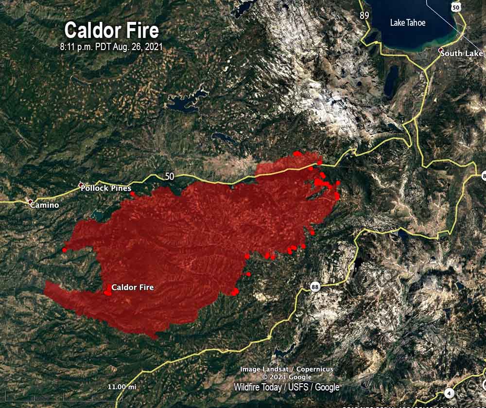
Additional evacuations were ordered on the 143,000-acre Caldor Fire Thursday. The blaze was very active on the northeast side, and that continued into the night due to the humidity rising to only 22 to 28 percent. Short-range spotting produced numerous spot fires across control lines. The wind subsided after midnight and the spread of the fire slowed.

Firefighting aircraft were hampered Thursday with visibility degraded by smoke.

The growth was primarily to the northeast as the fire moves closer to the small communities along Highway 50. Unofficial distances from the fire were measured based on a mapping flight at 8:11 p.m. PDT August 26. This information should not be used for planning or making decisions about evacuation. Strawberry, 1.5 miles; the southern junction of Highways 50 and 89, 8 miles; Fallen Leaf Lake, 8 miles; Lake Tahoe shoreline, 11 miles.

For Friday firefighters expect the growth will continue in the northeastern areas but will be moderated by the arrival of light winds. Spot fires are likely to occur some distance from the fire’s edge and previously undetected sleepers caused by burning embers from earlier activity may emerge. In the evening the light winds will allow nighttime inversions to form.

Caldor Fire map
Caldor Fire, mapped by a fixed wing aircraft at 8:11 p.m. PDT August 26, 2021.

The weather forecast for Friday at 6,000 feet is for 8 mph winds out of the northwest with humidity in the mid-teens and a high of 78 degrees. Saturday will be warmer with lower humidity and 8 mph hour winds out of the south and west.

The fire has destroyed 469 residences and 181 other structures; more than 18,000 are threatened. The El Dorado County Sheriff in collaboration with CAL FIRE has released a map displaying properties that have been inspected for any damage or that have been destroyed by the Caldor Fire.

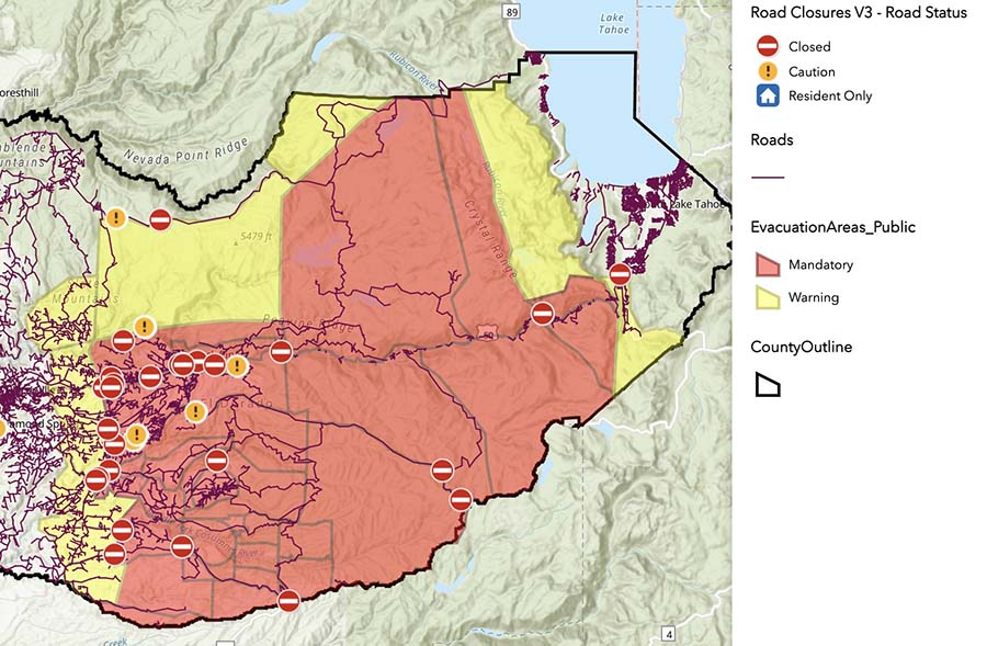
Mandatory evacuations are in place for 33,723 residents as well as warnings that mandatory evacuations may occur for other areas in the future.  Evacuation notices are posted by the El Dorado County Sheriff’s office. Below is a screenshot from the Sheriff’s website, obtained at 7:11 a.m. PDT August 27, 2021. Go to their site for current information.

Caldor Fire evacuation map
Caldor Fire evacuation map, obtained from the El Dorado County Sheriff’s website at 7:11 a.m. PDT Aug 27, 2021.

Resources assigned to the fire Thursday evening included 250 fire engines, 63 water tenders, 25 helicopters, 82 hand crews, and 71 dozers for a total of 3,204 personnel.

In the two weeks it has been burning, the average daily suppression cost of the Caldor Fire is $3.4 million; about $24 an acre. And it is far from being over.

The number of residences destroyed in Dixie Fire increases to 690

Posted on Categories WildfireTags ,

139 commercial buildings have been destroyed

12:45 p.m. PDT August 26, 2021

Dixie Fire map
Dixie Fire map, northwest section. The fire was mapped by a fixed wing aircraft at 8 p.m. Aug. 25, 2021. The red areas had extreme heat during the flight.

The Dixie Fire near Susanville, California has burned 747,091 acres and has run up fire suppression costs of more than $365 million. At last count 690 residences and 139 commercial buildings had been destroyed. A map is available showing which structures have been surveyed for damages.

There are two areas on the fire that had large concentrations of heat when the fire was mapped Wednesday night. One was the northeast section south of Highway 44, 6 miles southeast of Old Station. After burning much of the east side of Lassen Volcanic National Park the fire ran an additional three miles north. During the 8 p.m. mapping flight Wednesday night it was a mile south of Highway 44. The fire is still very active in the center of the park and outside its northeast corner.

Dixie Fire map
Dixie Fire map, southeast section. The fire was mapped by a fixed wing aircraft at 8 p.m. Aug. 25, 2021. The red areas had extreme heat during the flight.

The other very active area on the Dixie fire is east of Taylorsville and around the Genesee Valley. Wednesday night hotshot crews continued to work the fire down off Mt. Jura to the valley bottom to secure Taylorsville. No spots have occurred. On Thursday resources will focus on holding this line. Crews have been actively engaged in structure protection in the Genesee Valley near Ward Creek and Little Grizzly Creek as the Peel Ridge spot fire backed down into the valley. They will continue this work Thursday.

(To see all articles on Wildfire Today about the Dixie Fire, including the most recent, click HERE.)

The Dixie Fire burned into the footprint of the 2019 Walker Fire, spreading for approximately a quarter of a mile inside, along 10 miles of Walker’s western perimeter.

On Thursday firefighters will construct direct and indirect line to secure fire lines in the Westwood area, which they expect will require a heavy resource presence.

Temperatures Thursday are expected to increase while winds from the north and northwest decrease to six mph out of the west-southwest. The relative humidity will be in the low 20s with very little cloud cover.

Dixie Fire vicinity map
Dixie Fire vicinity map, 8 p.m. Aug. 25, 2021.