Eucalyptus trees contribute to Portugal’s wildfire problem
When numerous fires burned through large expanses of Portugal in June killing more than 60 people, they were fueled in some areas by monocultures of eucalyptus trees. Many areas around the world grow them in order to harvest the wood, leaves, and oil to make paper and medicine. But wildfires burn rapidly under the trees and through the crowns, fed by the stringy bark, oil, and the leaves and forest litter on the ground that do not decompose. Earlier this year we took this photo after a fire in Chile spread through a plantation.

The New York Times published an article today that looks at how eucalyptus and other issues combine to create a wildfire environment in Portugal that is difficult to manage.
Here is an excerpt:
…Even so, Portugal’s wood industry no longer relies on native species like oak and pine. Instead, it is increasingly built on eucalyptus, which feeds a pulp and paper sector that makes up 10 percent of Portuguese exports. The area of eucalyptus planting has more than doubled since the 1980s.
Eucalyptus can be harvested in half the time needed for pine. And unlike other species, “you have absolutely no need for people on the ground” to supervise its growth, said João Camargo, an environmental engineer.
The tree, however, contains a highly flammable oil that helps fires erupt more easily, spread and intensify.
Yet after every fire, more landowners switch to eucalyptus, hoping that a shorter production cycle can allow them to recoup their losses faster and to harvest their trees before the next fire erupts.
It is an accelerating sequence that has turned Portugal “from a pretty diverse forest into a big eucalyptus monoculture,” Mr. Camargo said.
Eight firefighters injured in northern California vehicle accident
A crew truck from Firestorm Wildland Fire Suppression was involved in the one-vehicle accident.
 At approximately 7:45 a.m. PDT, August 11, 2017, a Firestorm Wildland Fire Suppression Inc. contracted fire crew transport truck assigned to the Parker 2 Fire was involved in a single vehicle accident on Highway 299 near Cedarville, California. Eight firefighters were injured. Five were transported to local medical facilities by ambulance; three were transported by air ambulance. Seven of the firefighters have been treated and released, and one firefighter is still undergoing medical evaluation.
The truck rolled over after the driver tried to avoid hitting a vehicle that had stopped due to deer being in the road.
The Parker 2 Fire has burned almost 8,000 acres on the Modoc National Forest east of Alturas, California.
Thanks and a tip of the hat go out to Rick.
Typos or errors, report them HERE.
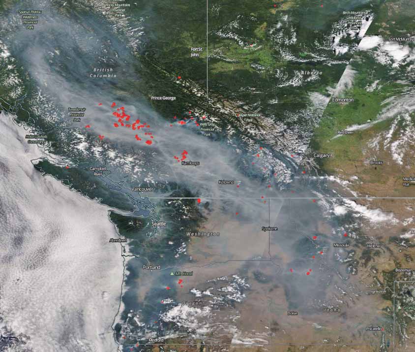
15,000 firefighters are battling 83 wildfires in the United States
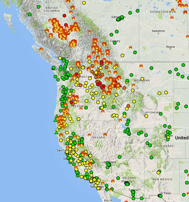
Above: Map showing heat detected on wildfires in the northwest one-quarter of the U.S. by a satellite, August 10-11, 2017. NASA.
(Originally published at 12:34 p.m. MDT August 11, 2017)
Over 15,000 firefighters are assigned to 83 active wildfires in the United States which have burned a total of about 942,000 acres. In addition to fire overhead and incident command post personnel, they are staffing 369 hand crews, 678 fire engines, and 141 helicopters. So far this year over 6 million acres have burned in the country.
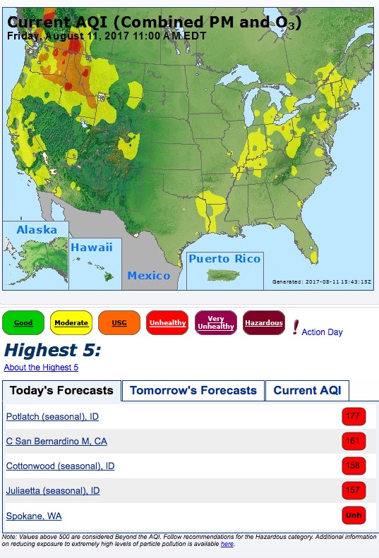
As you can see below, the air quality compromised by smoke is not getting any better. Again, four cities in Idaho and Washington are four of the top five locations in the country with forecasts for the worst air today.
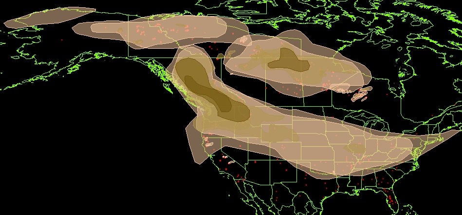
Wildfire smoke and air quality, August 10, 2017
Above: map showing the distribution of wildfire smoke at 5:34 p.m. MDT August 10, 2017. NOAA.
(Originally published at 6:09 p.m. MDT August 10, 2017)
Judging from these maps, the air quality in southern British Columbia and the U.S. Northwest looks particularly rotten today. (“Rotten” is not a term I’ve seen NOAA use to describe air quality, but it seems appropriate here.)
Locations in Washington and Idaho had the distinction of taking four of the top five positions on the forecast for the “highest 5”, AKA worst air, in the United States today.

Senator says to DOI official, “Don’t hold us back” from getting location tracking devices for our firefighters
(Revised August 15, 2017)
During an August 3 hearing before the Senate Committee on Energy and Natural Resources the main topic was “the use of technology to reduce wildland fire risk to communities and enhance firefighting safety and effectiveness”.
Near the end of the hearing Senator Maria Cantwell, the ranking member, asked Bryan Rice, the Department of Interior’s Director of the Office of Wildland Fire, about using devices that can track the location of firefighters in order to reduce their risk of entrapments. She used the example of an award that was presented to a U.S. Fish and Wildlife employee who successfully used hardware designed for tracking hunting dogs to track his firefighters, which helped one person to be directed to a safe area after becoming disoriented on a prescribed fire. She said why not combine the use of drones, which had been discussed previously, with tracking devices. I’m not sure exactly what she meant, but regardless she has a good point. Drones could serve at least two purposes — provide real time video of the location of the fire, and relay location data from firefighters.

Mr. Rice’s answer included the phrase, “we’re looking at it”, which did not satisfy Senator Cantwell. She expanded on her thoughts and made it very clear that this is an important area to address, mentioning several examples of tragedy fires, including the South Canyon, Thirty-mile, and Yarnell Hill fires.
The Senator said to Mr. Rice, “Don’t hold us back from getting solutions in the marketplace this summer if we can”.
You can see how this went down in the video below. (The video was replaced with a better version August 15, 2017.)
Our regular visitors at Wildfire Today know that we have ranted many times about what we call the Holy Grail of Wildland Firefighter Safety — knowing the real time location of the fire and firefighters — as early as October, 2013. Not knowing these two pieces of information has led to dozens of fatalities. Two fires that come to mind in the last decade or so are the Esperanza and Yarnell Hill Fires, in which 24 firefighters were killed.
If you can go to Cabelas and buy a kit that will track up to 10 hunting dogs, why, Senator Cantwell asked, can’t we do that for firefighters?
The Senator knows that dog collars are not the long-term answer, of course, and they may or may not work over distances in rough terrain, but it’s an example of off the shelf technology that is available this afternoon. Several private companies claim to have more robust systems that can do this for wildland firefighters.


