Unusual weather allows broader range of fire management options in Arizona

Camillo Fire
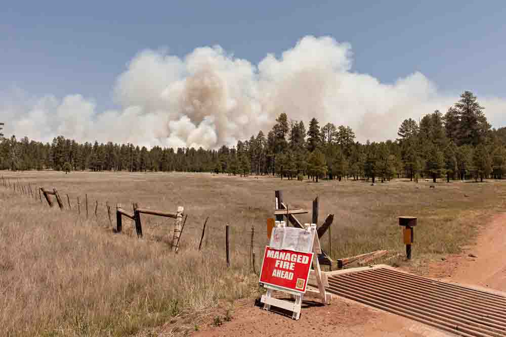
A “Managed Fire” sign was in place to inform the public about the Camillo Fire on the Coconino National Forest.

This has not been a typical fire season in the southwest United States. A series of spring storms kept the high country wet and cool, even bringing snow to the upper elevations in late May. The remnants of two hurricanes off the west coast of Mexico imported moisture and moderated temperatures on the deserts until recently.

Many of the forests in both Arizona and New Mexico have been using the few lightning starts to date as a chance to use naturally occurring low intensity fire to play a crucial role in restoring forest health and fuels reduction.
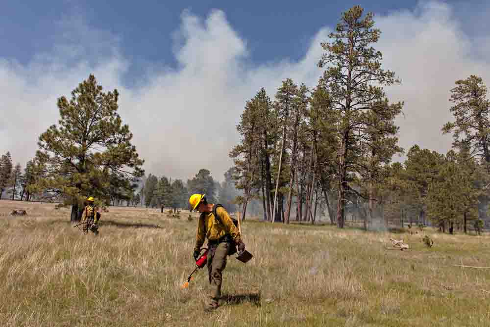
Camillo Fire
Ed Olague, with Coconino National Forest Engine 483, finishes a firing operation on the Camillo Fire. This burnout had 27 people firing; each one chain (66 feet) apart, putting a dot of fire every half chain. The 1000 acre block was burned in four and half hours.

The Camillo Fire southeast of Flagstaff, Arizona is one of the largest of these fires.  Starting with a lightning strike near Mormon Lake on June 14, officials on the Coconino National Forest began to manage the fire rather than suppress it. Brady Smith, the forest’s Public Affairs Officer explains their objectives: “Overall, we seek to maintain a healthy ecosystem by reintroducing natural fire back into the forest that will burn at a lower intensity and ‘creep’ across the forest floor, acting as a natural janitor cleaning and restoring the forest to a healthier condition. Ultimately, this type of fire helps reduce buildup of down and dead wood and forest fuels, making it safer for communities and lessening the chances of a large severe wildfire in that area.”

At the time of this writing, the fire was 17,596 acres and while the Maximum Management Area (MMA) is nearly 46,000 acres, Don Muise, Fire Staff Officer on the Coconino National Forest explains that: “Not all 46,000 acres will see fire. We have excluded acres from the MMA due to a variety of reasons including protection of critical wildlife habitat (particularly Mexican spotted owl habitat), protection of archeological and cultural resource sites, exclusion of private inholdings, protection of critical range pastures and range improvements, etc.  Additionally, along the eastern edge of the MMA, the continuous ponderosa pine ecosystem transitions to a pinyon/juniper grassland that may not burn given the current and predicted conditions.  Right now our best guess for total acres burned is from 25,000 to 30,000 acres.”

The monsoon season brings frequent thunderstorms into Arizona and New Mexico, usually beginning in late June and lasting into September.  Asked about the monsoons, Mr. Muise continued: “We will continue to manage fire within the MMA as conditions allow. If the monsoon sets up in earnest and we get significant moisture, we will reduce our committed resources to an appropriate level and monitor the area until the fire is out.   If drying conditions follow the moisture, and, if there is still the potential for the fire to grow (if the fire survives the moisture), we will ramp up our operations to an appropriate level and continue our restoration efforts until all the available operational blocks within the MMA are completed.”
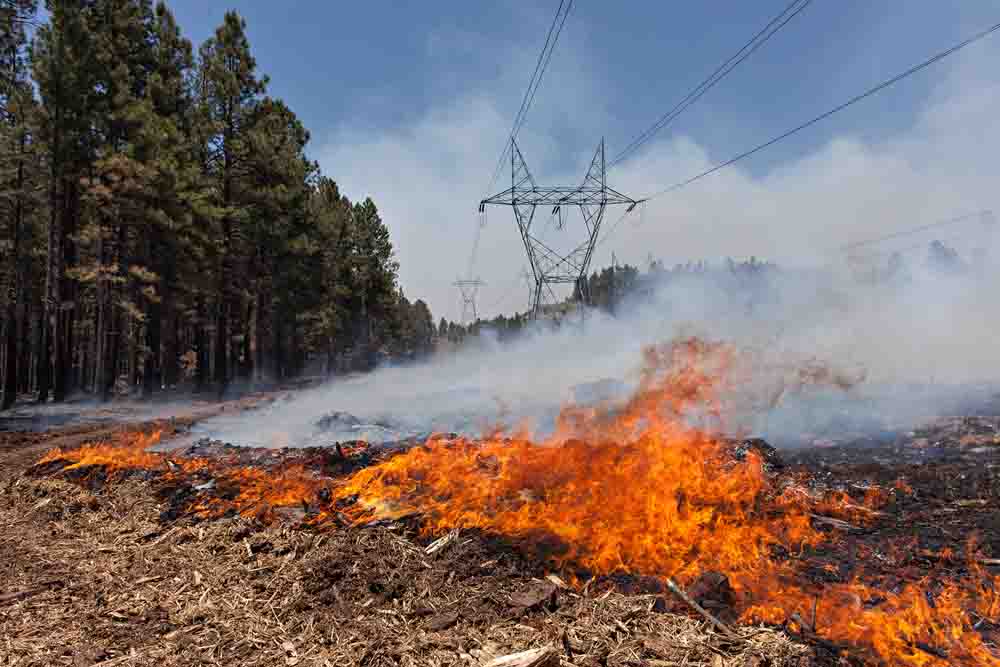
Camillo Fire
The Camillo Fire backs through piles of masticated material under a 345 Kv power line which brings electricity from Glenn Canyon Dam to the Phoenix Metro area. The power company, Arizona Public Service, maintains the right of way.

(More photos are below)  Continue reading “Unusual weather allows broader range of fire management options in Arizona”

Firefighting train used on Kearney River Fire

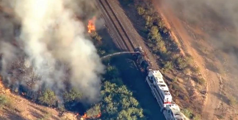
Firefighting Train Kearney
A firefighting train working on the Kearney River Fire. Screen grab from AZcentral video.

A firefighting train was used on the Kearny River Fire near Kearny, Arizona this week. Below is an excerpt from an article at AZcentral, which also has a video of the train in action.

…Arizona State Forestry spokesman Mike Reichling said this was the first time he had seen a train used at the scene of a wildfire. Two Copper Basin Railway cars equipped with water cannons have been blasting hot spots along the Gila River bed near Kearny, about 85 miles southeast of Phoenix. While helicopters and dozers have been tackling the fire, the train has played a key role.

“We work very closely with the firefighters,” Railway President Jake Jacobson said. “We can help to provide them water in remote places.”

The water tank cars, which are only operated by Copper Basin employees, have been focusing on dousing hot spots while they ride the tracks. Each car can hold 15,000 gallons of water and disperse it as far as 250 feet, Jacobson said. The rail tank cars were transformed as water tank cars in the mid-1990s. Based in Hayden, the Arizona short-line railroad stretches 54 miles from Magma to Winkelman.

We have written about firefighting trains twice before, using the tag Water Train.

More information about the Kearny River Fire (which has not spread much in the last day or two). The incident management team on June 19 called it 1,428 acres and 40 percent contained.

Thanks and a tip of the hat go out to Jason.

Arizona: Kearney River Fire

(UPDATE at 10:05 p.m. MT, June 20, 2015)

Not much new information is available about the Kearney River Fire at Kearney, Arizona. The satellite has not detected any new heat in the last 24 hours, and the incident management team is calling it 1,428 acres and 40 percent contained.

****

(UPDATE at 4:50 p.m. MDT, June 18, 2014)

The Kearney River Fire is now reported to be 1,100 acres. Firefighters are conducting burnout operations on the north side of the fire which will put more smoke into the air.

****

(UPDATE at 8:18 a.m. MDT, June 18, 2015)

Kearney River fire 333 am MDT June 18, 2015
Map showing heat detected on the Kearney River Fire (the red and brown squares) by a satellite at 3:33 a.m. MDT June 18, 2015. The red icons are the most recent.

Above is the most recent data available about the location of the Kearney River Fire at Kearney, Arizona. It continued spreading to the north after the previous map 12 hours earlier. The Incident Management Team in a Thursday morning update increased the reported size from 300 to 400 acres, but looking at the map, it appears to be larger.

The weather forecast for Thursday is not helpful for the firefighters, with a prediction of 113 degrees, winds out of the northwest at 10 to 15 mph, and a minimum relative humidity of 6 percent.

****

Kearney River Fire Arizona
People in the Breeezeway Trailer Park watch as the Kearny River Fire continues to move north through the dense vegetation of the Gila River bottom north of Kearny, Arizona. Photo by Tom Story.

Tom Story, who took these photos for us, said the Kearney River Fire near Kearney, Arizona “has split, with one end backing into the wind and the southern end of the fire being driven by 10 to 15 mph winds. The town of Kearny is pretty safe but several structures have been lost at this time. 108 degrees 11 percent.”

The fire has burned 300 acres, as well as two residences, two outbuildings, and one vehicle. The evacuation order has been lifted for some parts of Kearney.

It was reported at 11:03 a.m. on June 17.

Kearney River Fire
The northwest end of the Kearney River Fire backs into the wind through heavy fuels in the Gila River bottom near Kearney, Arizona, June 17, 2015. Photo by Tom Story.
Kearney Fire at 340 pm MDT June 17, 2015
Map showing heat detected by a satellite on the Kearney Fire at 3:40 p.m. MDT June 17, 2015.

Fatality during Work Capacity Test in Arizona

There has been another fatality of a person attempting to take the Work Capacity Test. There are three versions of the test — the most strenuous, the Pack Test, is required for federal wildland firefighters in order to become qualified to serve in a position which involves direct action on a wildland fire.

Below is the text from a preliminary 24-hour briefing from the U.S. Fish and Wildlife Service:

****

“THE FOLLOWING INFORMATION IS PRELIMINARY AND SUBJECT TO CHANGE

Location: Buenos Aires National Wildlife Refuge, Sasabe Arizona
Date of Occurrence: June 6, 2015
Time of Occurrence: Approximately 0800 hours
Activity: Work Capacity Test
Number and type of injuries/fatalities: One, Fatality
Property loss: None

Narrative:

At approximately 0800 hours on June 6, 2015, a 31 year old Student Conservation Association (SCA) employee, Veteran Fire Corps crewmember, collapsed 200 yards from the finish line while participating in the Wildland Firefighter Work Capacity Test. Medical care was immediately rendered by on-site, local EMS including the utilization of an Automated External Defibrillator (AED). The individual was loaded in the Ambulance, which had been staged on-site for the test, within 5 minutes of his collapse and transported to an Advanced Care Facility.

The cause of death has not yet been determined.

The name of the deceased has not yet been released pending family notifications.” (end of report)

(UPDATE, June 9, 2015: the name of the firefighter has been released.)

****

Here are examples of five other fatalities while taking the Pack test.

In 2012 there was a near fatality during the test when a firefighter in Indiana suffered a full cardiac arrest. Thankfully, as a result of the precautions that were in place, including the presence of an Automatic External Defibrillator (AED), there was a positive outcome.

Related:
Articles on Wildfire Today tagged “Pack Test”.

How prior fuel treatments affected the San Juan Fire

San Juan Fire severity
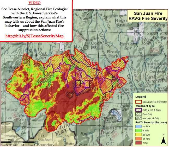
Map of the San Juan Fire “Rapid Assessment of Vegetation Condition after Wildfire”. The fire started at the south end near “San Juan Flat and eventually burned into many treated areas, represented by cross-hatching, where the fire intensity and rate of spread decreased.

The U.S. Forest Service has put together information about how previous fuel treatments modified fire behavior on the San Juan Fire on the Apache-Sitgreaves National Forest in Arizona in June of 2014. Below is an excerpt from a report, and below that is a video in which subject matter experts describe the effects of the treatments.

Generally speaking, the fuel treatments encountered by the San Juan Fire were effective at modifying fire behavior. Furthermore, these fuel treatment areas proved to be instrumental in providing fire managers with opportunities to contain the fire in a safe and effective manner while simultaneously limiting the fire’s potential negative effects on natural resources, the surrounding communities and their infrastructure.

Fire behavior observed by firefighters at the scene—as well as estimates of fire severity taken after the fire confirm that the treated areas performed as designed by not supporting sustained crown fire even under extreme burning conditions.

As the San Juan Fire transitioned from untreated mixed conifer to treated ponderosa pine, fire behavior also transitioned from intermittent and sustained high-intensity crown fire in the untreated stands to a low-moderate intensity surface fire in the treated stands.

Thus, firefighters were able to utilize the road system within the treated stands to implement their burnouts. These burnout operations limited the forward progress at the head of the fire the day after the fire started.

Arizona: Oak Tree Fire

Oak Tree Fire

In the 24 hours since it started on May 20, the Oak Tree Fire has burned about 2,000 acres on the Coronado National Forest and BLM land near State Highway 83 about 10 miles north of Sonoita, Arizona.

Oak Tree Fire

Fire managers have provided a copious amount information on InciWeb, and quickly. Here is an excerpt, updated this morning, May 21:

****

“Air attack flew the fire this morning and reported minimal fire activity, however fire activity is expected to increase throughout the day as temperatures warm and winds increase. SW winds may increase to 15-20 mph with gusts to 35 mph this afternoon. Fire managers plan to fly a reconnaissance mission this morning and will be mapping the fire by GPS to provide a better size estimate. Ten additional fire engines from across Southeast Arizona arrived this morning. Two additional handcrews have been ordered and are expected to arrive mid-day today. Firefighters plan to take advantage of increased relative humidity and lighter winds this morning to build on yesterday’s progress. They plan to finish constructing fireline around the fire, focusing on a remaining section to be completed on the northeast flank of the fire. They will continue to monitor, hold, and strengthen fireline throughout the day. Air tankers and helicopters are available to drop water and retardant as needed to cool hotspots and slow the fire’s spread.

Current resources include two handcrews (two additional crews have been ordered and are expected to arrive mid-day), eighteen fire engines, four water tenders, one air attack platform, five air tankers, two helicopters and miscellaneous overhead, for a total of more than 100 people assigned.”

Oak Tree Fire Oak Tree Fire

The first three photos were provided by the Sonoita-Elgin Fire District. The bottom aerial shot is from InciWeb.