United States asking Australian firefighters for help

The Australian ABC News Service reports the US is asking for 188 specialist firefighters

(UPDATED at 12:36 p.m. MDT August 1, 2018)

On Wednesday, August 1 the National Interagency Fire Center issued a press released about the United States requesting firefighters from Australia and New Zealand to assist with suppressing wildfires in the Western United States. In addition to our report on July 31 (below) the NIFC release had this additional information:

The request is for fire personnel from both Australia and New Zealand.

The request is for Division Supervisors, Safety Officers, Task Force Leaders, Strike Team Leaders, Heavy Equipment Bosses, Helicopter Managers, Helicopter Crew Members, Structure Protection Specialists and Liaison Officers. These wildland fire management positions have been identified as “unable to fill” through the U.S. dispatch/coordination system on a daily basis in recent weeks.

In addition to the firefighters sent from “down under” in 2008 and 2015, they also assisted during the 2000, 2002, 2003 and 2006 fire seasons. U.S. firefighters traveled to Australia to assist with their fire seasons in 2010, 2009, 2007 and in 2003.

(End of update)


(Originally published at 2:41 p.m. MDT July 31, 2018)

The United States is seeking help from the other side of the world to help suppress some of the 140 large active wildfires that have burned a cumulative 1.2 million acres. We confirmed with Randy Eardley, a spokesperson for the Bureau of Land Management, that the process of requesting help from Australia is underway but all of the details have not yet been worked out.

Much more information about the effort was published by the Australian ABC News Service which had an article about the request on Monday (US time). Here is an excerpt:

The National Multi-Agency Coordination Group (MAC) in the US formally requested assistance over the weekend, seeking 188 specialist firefighters from Australia and New Zealand.The firefighters would be deployed for up to 42 days in the California area.

Candidates from each Australian state will be placed in a national pool, with the most suitable candidates chosen this afternoon ahead of their deployment to the US on Friday.

South Australian Country Fire Service spokesman Brett Williamson said the most suitable firefighters to come forward in South Australia so far had experience fighting fires in areas with rough terrain and forests.

“We are finding it is more the state-based ones — in particular [those from] the South East and the Port Lincoln area … that are the ones who will probably have the beneficial skills that the United States [is] searching for,” Mr Williamson said.

The US has asked for paid staff rather than volunteers.

“At this stage, we are still calculating the numbers of who is available, who will be available from their employers to be released and then they will go into a national pool and that national pool will then basically be cherry-picked for the best people that are suitable for the job,” Mr Williamson said.

Australia also sent help in 2008 and 2015. The 2015 request was for 71 fire managers and specialists who came from Australia and New Zealand. They arrived in Boise August 23 for a one-day induction to learn about current fire behavior, fuels, and weather conditions. After the orientation, they were assigned to large fires. The 2015 contingent included 15 Division Supervisors; 15 Task Force/Strike Team Leaders; 15 Helicopter Managers; 10 Heavy Equipment Bosses; 10 Safety Officers; 4 Regional Liaison Officers; and two National Liaison Officers.  Fifteen of the total were from New Zealand.

There were 45 firefighters in the 2008 group.
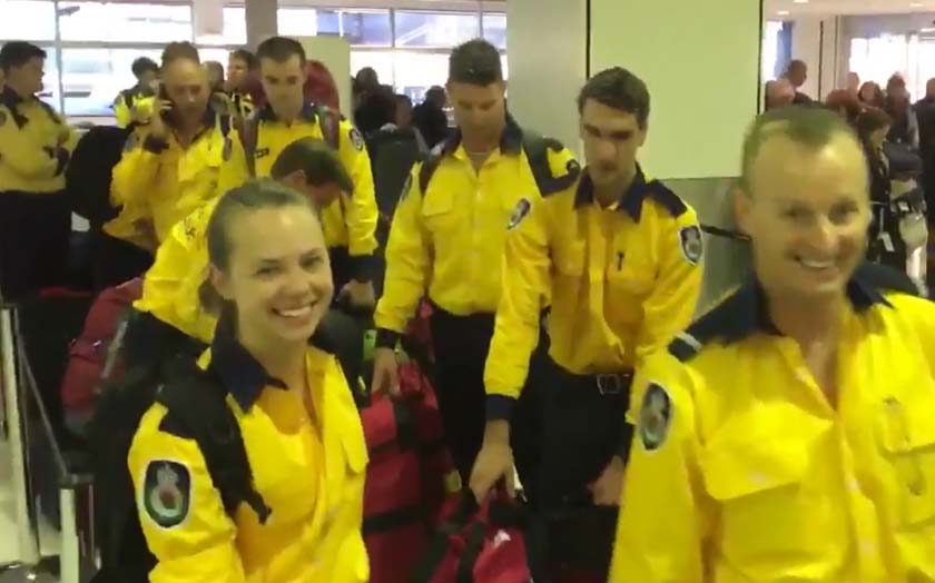
NSWRFS firefighters British Columbia
File photo: On August 8, 2017, 40 firefighters from Australia’s New South Wales Rural Fire Service joined 60 others from across the continent as they began their travel to British Columbia to assist with wildfires in Canada. Screenshot from NSWRFS video.

Assistance from Australia and New Zealand is a good fit primarily because their fire organizations are very similar to the United States national fire organization in training requirements and structure.

In 2010 the United States and Australia signed a Memorandum of Understanding to strengthen emergency management cooperation between the two countries. One of the objectives was to streamline processes for emergency management authorities in both countries to facilitate the exchange of personnel in response to emergencies.

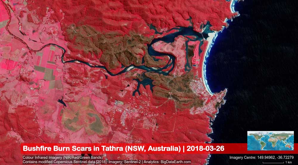
Burn scars of the fire that burned into Tathra, NSW

(Originally published at 3:26 MDT March 27, 2018)

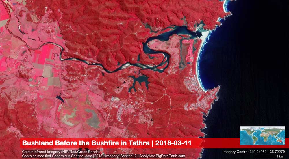
These satellite images show before and after photos of the March 18, 2018 bushfire that started southeast of Bega, NSW, Australia, and burned into Tathra, destroying at last count 69 homes.

The images were captured by the Sentinel-2 satellite system (March 26, 2018, 11:02 am local time) and were analyzed by BigDataEarth.com.

map tathra NSW wildfire homes destroyed
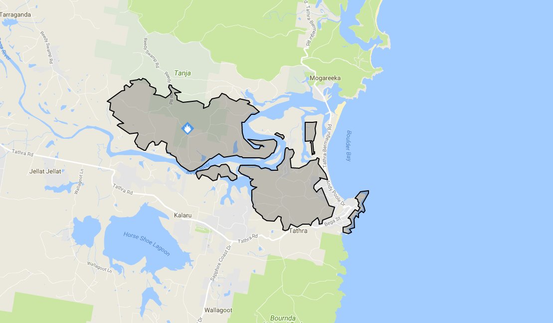
Map showing the area in New South Wales between Bega (on the left) and Tathra (on the coast on the right) before the fire.
map tathra New South Wales wildfire
Map showing the area in New South Wales between Bega (on the left) and Tathra (on the coast on the right) after the fire. The brown areas represent the burned area.

69 homes believed destroyed in New South Wales bushfire

Above: A fire burns structures in Tathra, New South Wales. Photo credit: NSW Rural Fire Service.

(Updated at 8:30 a.m. MDT March 19, 2018, US time)

At least 69 homes were destroyed and 39 damaged in the bushfire that spread into the coastal community of Tathra in New South Wales according to the Rural Fire Service.

As the fire ran into the town many residents took refuge on the beach, but very strong winds, smoke, and blowing sand convinced some to leave and head for the evacuation center in Bega.

The fire has burned approximately 1,200 hectares (2,965 acres).

map fire tathra
Map of the fire near Tathra, New South Wales. NSW RFS.


(Originally published at 11:03 a.m. MDT March 18, 2018, US time)

A fire that started southeast of Bega, New South Wales has burned east to the Pacific coast destroying homes in its path. The official tally of the affected structures is not available but Campbell Fuller, communications director of the Insurance Council of Australia, said “We are hearing several dozen properties” burned.

map bushfire Tathra new south wales
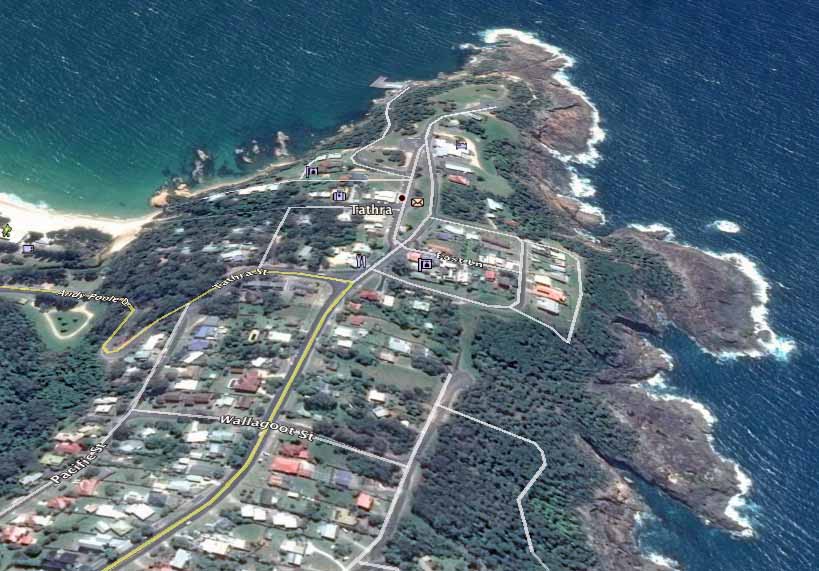
Google Earth file photo of the area in Tathra NSW affected by a bushfire. Compare this image to the one at the top of the article.

From the Daily Telegraph:

Earlier on Sunday night Bega Valley Shire Council mayor Kristy McBain said up to 35 homes had been lost and the concern was now about people stuck in Tathra as the roads in and out of the town were closed.

Many of the destroyed homes were in the small coastal community of Tathra, population 1,622. After the fire ran east for 5 miles (8 km) from the Bega area to the coast, jumping the Bega River, the wind shifted to come out of the south, slowing the spread. Officials advised residents to continue to monitor conditions and be prepared to enact their bush fire survival plan should the fire threaten again. The evacuation center is at Bega Showground.

map bushfire Tathra new south wales
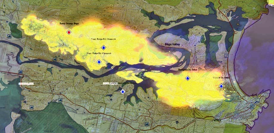
Map of the bushfire between Bega and Tathra NSW. Map by NSW RFS.

The NSW Rural Fire Service video below shows Air Tanker 390 making a drop in Tathra.

The latest size of the fire released by the Rural Fire service at 23:10 March 18 local time was 1,000 hectares (2,470 acres).

bushfire Tathra new south wales
Air Tanker 390 makes a retardant drop near structures in Tathra, NSW. Photo credit, NSW RFS.


Firefighters and aircraft are being kept busy in New South Wales

(This article was first published on Fire Aviation)

A post shared by Charlton Durie (@charltondurie) on

Click on the image above to start the video. Then, to see a second video, click on the arrow on the right side of the image.

Instagram user “charltondurie” grabbed this photo and video of Air Tanker 912, a DC-10, dropping retardant on a fire about 70 miles (110 km) southwest of Sydney in New South Wales, Australia that has burned 1,880 ha (4,645 acres) northeast of Taralga between Bannaby and Wombeyan Caves.

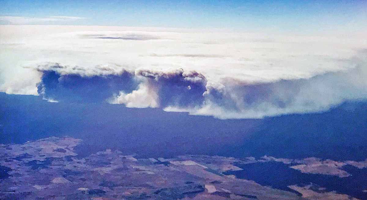
A huge fire in the Pilliga Forest between Coonabarabran and Narrabri has blackened over 57,880 hectares (143,000 acres).

Lightning ignited multiple fires across the Blue Mountains and Yengo National Parks in NSW Monday evening. There are two fires burning in remote areas to the north of the Great Western Highway in the Grose Valley, Blue Mountains National Park and an additional six fires south of the Great Western Highway and north of Warragamba Dam in the Blue Labyrinth, Blue Mountains National Park. The aircraft is named “Nancy Bird” after an Australian aviatrix.

There is also one fire in the Yengo National Park, east of the Putty Road in the Hawkesbury.

These lightning fires are burning in remote areas. NSW  Rural Fire Service and  National Parks and Wildlife Remote Area Firefighters have worked to establish and consolidate containment lines with the support of air tankers.

PIlliga Fire closes Newell Highway in New South Wales

Above: The Pilliga Fire 60 km southwest of Narrabri, New South Wales, Australia. Modified Copernicus Sentinel satellite data  processed by Pierre Markuse.

(Originally published at 8:46 MST January 19, 2018)

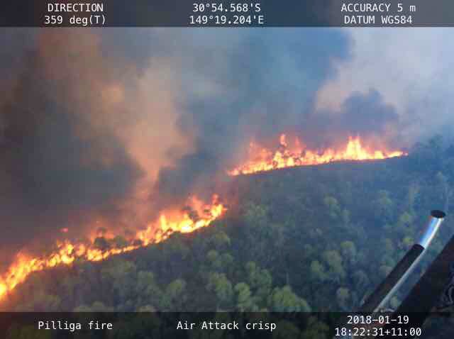
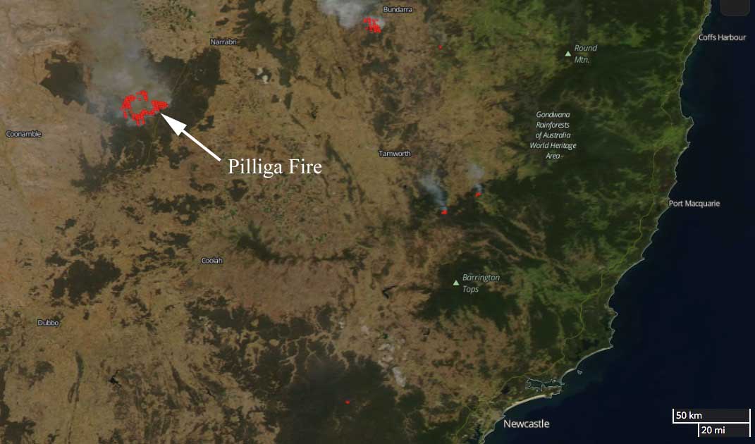
The Pilliga Fire in Australia between #Coonabarabran and #Narrabri has burned approximately 20,000 hectares (49,400 acres) in New South Wales, requiring the closure of the Newell Highway. The fire is burning near Dipper Road, Dandry, in the Pilliga Forest west of the highway.

Pilliga Fire New South Wales
Pilliga Fire 60 km southwest of Narrabri, New South Wales, Australia.

The Rural Fire Service reports that smoke is likely to drift across the Wee Waa, Gwabegar, and Baradine areas. There is, however, no current threat to homes.

Pilliga Fire New South Wales
Pilliga Fire 60 km southwest of Narrabri, New South Wales, Australia.

map Pilliga Fire New South Wales

Bushfire in NSW threatened communities north of Newcastle

On Saturday January 13 a bushfire near Masonite Road threatened the communities of Tomago, Williamtown, and Raymond Terrace 17 Km north of Newcastle, New South Wales, Australia.

(If you don’t see the video below shot from an air attack aircraft, click HERE.)

The weather changed, bringing a little precipitation after it had burned 1,381 hectares (3,412 acre), slowing the spread. For a while the Newcastle airport was closed due to visibility reduced by smoke.

The fire was fought by 66 firefighters from the Rural Fire Service, Fire and Rescue, and the National Parks and Wildlife Service. They were assisted by helicopters and Air Tanker 912, a DC-10 that was recently renamed “Nancy Bird” in honor of an Australian aviatrix.