
The LNU Lightning Complex has grown to 302,388 acres
Continue readingSeveral AlertWildfire cameras burned over in California fires
Updated: August 20, 2020 | 2:04 p.m. PDT

At least two four fire monitoring cameras in the AlertWildfire system were burned over and possibly damaged by fires in northern California on August 19.
The Round Mountain Paskenta camera west of Corning was knocked off line at 4:59 p.m.
(To see all of the articles on Wildfire Today about the lightning-caused wildfires in California, including the most recent, click HERE.)


Later that night at 11:22 p.m. the Bonny Doon camera north of Santa Cruz recorded impressive fire behavior before it was no longer heard from.
Multiple fires merge in California’s North Bay area to burn over 215,000 acres
The LNU Lightning Complex of Fires is in Napa, Lake, Yolo, and Solano Counties
Continue readingCAL FIRE’s video briefing about statewide fires, and the LNU Complex of fires

At a briefing Wednesday the first minute and a half was about the statewide wildfire situation, then they moved on to details about the LNU Complex of fires in Napa, Lake, and Solano Counties of California.
(To see all of the articles on Wildfire Today about the lightning-caused wildfires in California, including the most recent, click HERE.)
Hennessey Fire spreads south toward Vacaville
The LNU Complex of fires has burned tens of thousands of acres in Napa and Solano Counties in northern California
Continue readingSeveral large fires burning north of Napa, CA in Lake Berryessa area
Hennessey, Gamble, and 15-10 Fires
Continue readingTime-lapse camera records moment a passing thunderstorm changes spread direction of Hennessey Fire
Napa County, California
Continue readingLightning ignites fires in San Francisco Bay Area
August 18, 2020 | 6:14 p.m. PDT
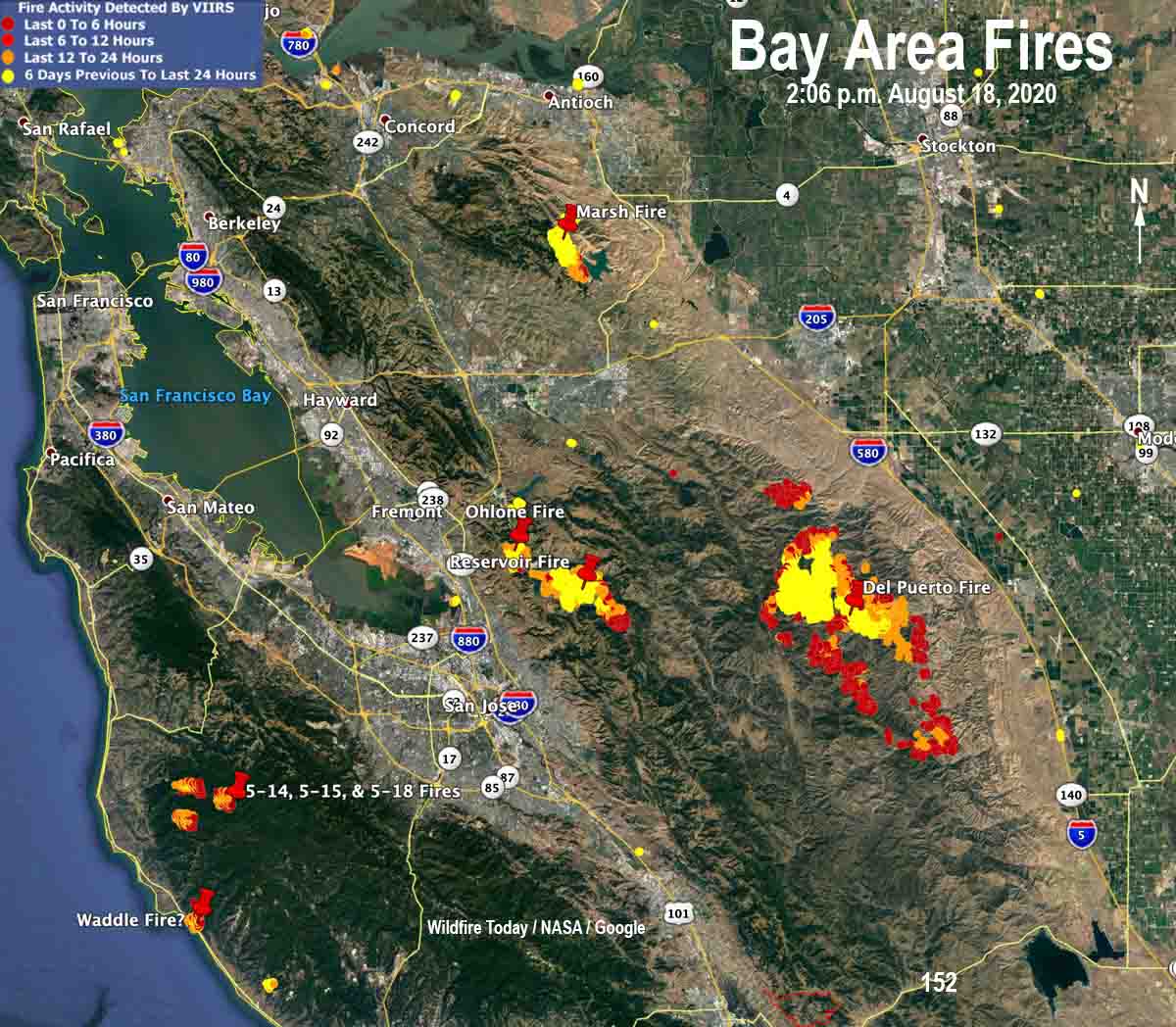
Most of the wildfires in the LNU Complex were very active Tuesday. Based on data from a satellite at 2:06 p.m. the Del Puerto Fire especially increased in size.
(To see all of the articles on Wildfire Today about the lightning-caused wildfires in California, including the most recent, click HERE.)
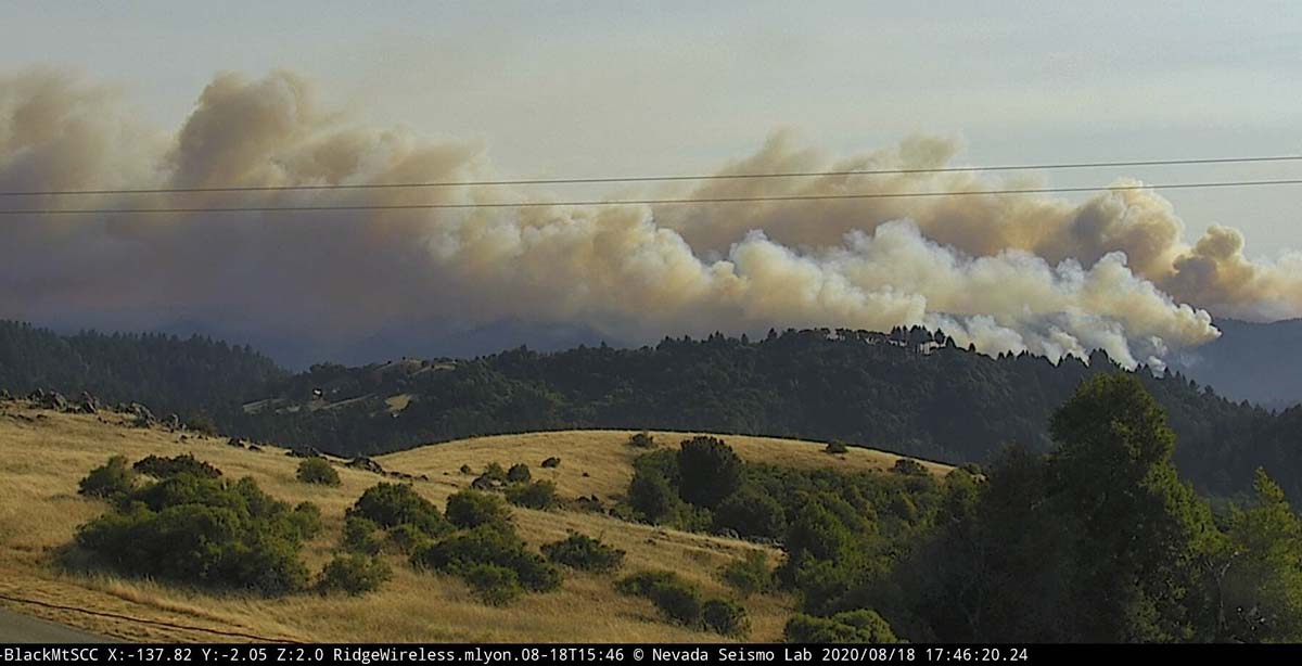
August 18, 2020 | 7:43 a.m. PDT
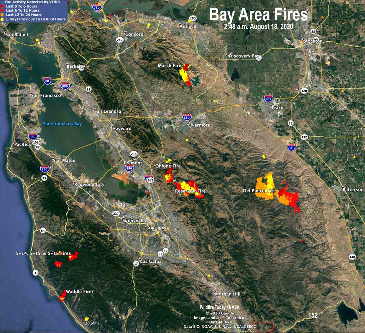
Most of the wildfires that started in the San Francisco Bay area in the last three days that escaped initial attack and were already large by Monday evening continued to grow into Monday night, according to heat data collected by a satellite at 2:48 a.m. PDT Tuesday.
At least 16 fires north and south of Livermore are being managed as one “complex”, the SCU Lightning Complex. SCU is the CAL FIRE unit responsible for the counties of Santa Clara, Alameda, Contra Costa, western Stanislaus, and San Joaquin. Some of the names of the individual fires have changed in the last 24 hours, but the largest blazes in the complex are Marsh, Ohlone, Reservoir, and Del Puerto.
Very little detailed information is available about the individual fires.
The Del Puerto Fire, formerly part of the Canyon Zone Fires, is about 10 miles west of Patterson and about three miles northwest of Diablo Grande. With all the name changes the size is not clear, but it is likely 5,000 to 15,000 acres.
The Ohlone and Reservoir Fires southeast of Fremont are adjacent to the Calaveras Reservoir three to seven miles east of the 680 freeway.
Fires that have been grouped into the CZU August Lightning Complex include the Waddle, 5-14, 5-15, and 5-18 Fires, plus other smaller fires. CAL FIRE says they total about 1,000 acres.
Outside of the South Bay area there are many other fires. Further north there are more than 60 fires combined in Butte and Napa Counties, for example.
There are reports that competition for firefighting resources is intensifying as requests placed by some incident commanders are unable to be filled (UTF). Firefighters in some cases are being asked to work double shifts. This situation is unlikely to improve soon, based on the extraordinary heat predicted for this week.
August 17, 2020 | 7:21 p.m. PDT
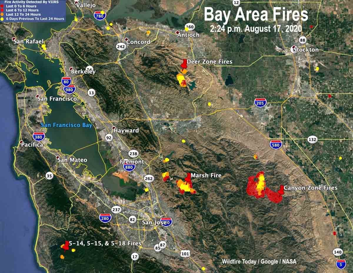
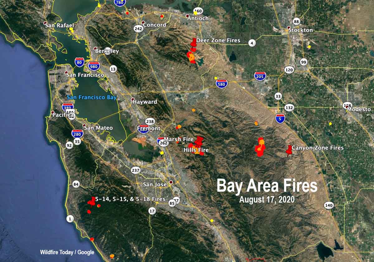
The map above is an updated version of the one below. The satellite heat data from 2:24 p.m. August 17 shows that the Canyon Zone Fires are growing rapidly toward the southeast and the west.
The Deer Zone Fire west of Los Vaqueros Reservoir was also active on the south side, but not to the same degree. It was mapped at 1,161 acres.
The Marsh Fire east of Milpitas was active at 2:24 p.m. Monday and has burned 1,775 acres.
The three fires oddly named 5-14, 5-15, and 5-18 did not create enough heat to be picked up during the latest satellite overflight at 2:24 p.m. Monday. They are about 5 miles east of Pescadero.
August 17, 2020 | 4:14 p.m. PDT
A rare series of intense summer thunderstorms passed through the San Francisco Bay Area Sunday morning and Monday morning. Some of the cells passed through so quickly there was little chance for precipitation.
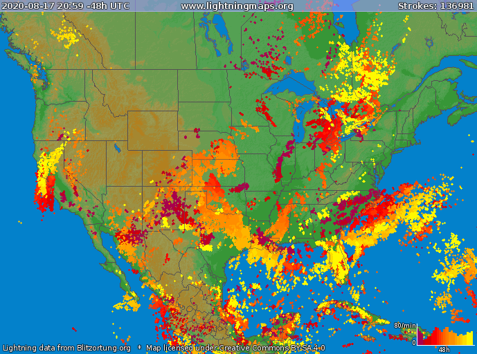
Numerous wildfires ignited and while not all of them have been investigated, lightning is the likely cause for many. Combined with winds that accompanied the storms with gusts of 50 to 70, very high temperatures, and a Red Flag Warning, there are so many fires now that they are difficult to track, at least from this writer’s vantage point.
The southern Bay Area has quite a few and there are others in the North Bay and Napa area.
There is competition for firefighting resources. Some of the incident commanders placing orders for aircraft, dozers, engines, or crews are at times being told that a particular order can’t be filled at that time, or there may be a lengthy delay.
From the Washington Post:
In California, the heat resulted in scores of record highs over the weekend including around Los Angeles, the San Francisco Bay area and Sacramento. Early Sunday morning, a bizarre “heat burst” raised the temperature 20 degrees in two hours in Fairfield, about 40 miles northeast of San Francisco. The temperature shot from around 80 to 100 degrees in the hours around sunrise.
The National Weather Service in San Francisco issued an unusually large severe thunderstorm warning that covered more than 7,000 square miles from Monterey Bay to the Bay Area and north into Napa Valley. The office warned of “erratic outflow wind gusts of 50 to 70 mph wind gusts, [and] frequent lightning.” The warning, the largest ever issued by that office, was six times larger than the state of Rhode Island.
“This 20-year forecaster cant recall such a widespread [thunderstorm] event on the heels of such a heat wave,” wrote one meteorologist in the office forecast discussion late Sunday.
We will add to this post later with more details about individual fires.
River Fire prompts evacuations south of Salinas, California
August 17, 2020 | 6:22 p.m. PDT

Not much additional information is available about the River Fire. Monterey County has current evacuation information. CAL FiRE has not updated the size since they announced it was 2,800 acres this morning.
(To see all of the articles on Wildfire Today about the lightning-caused wildfires in California, including the most recent, click HERE.)
Five structures have been damaged and there have been four “Confirmed Fire Personnel and Civilian Injuries” according to CAL FIRE.
Resources assigned include 10 hand crews, 2 helicopters, 55 fire engines, 9 dozers, and 6 water tenders for a total of 520 personnel.
August 17, 2020 | 7:13 a.m. PDT
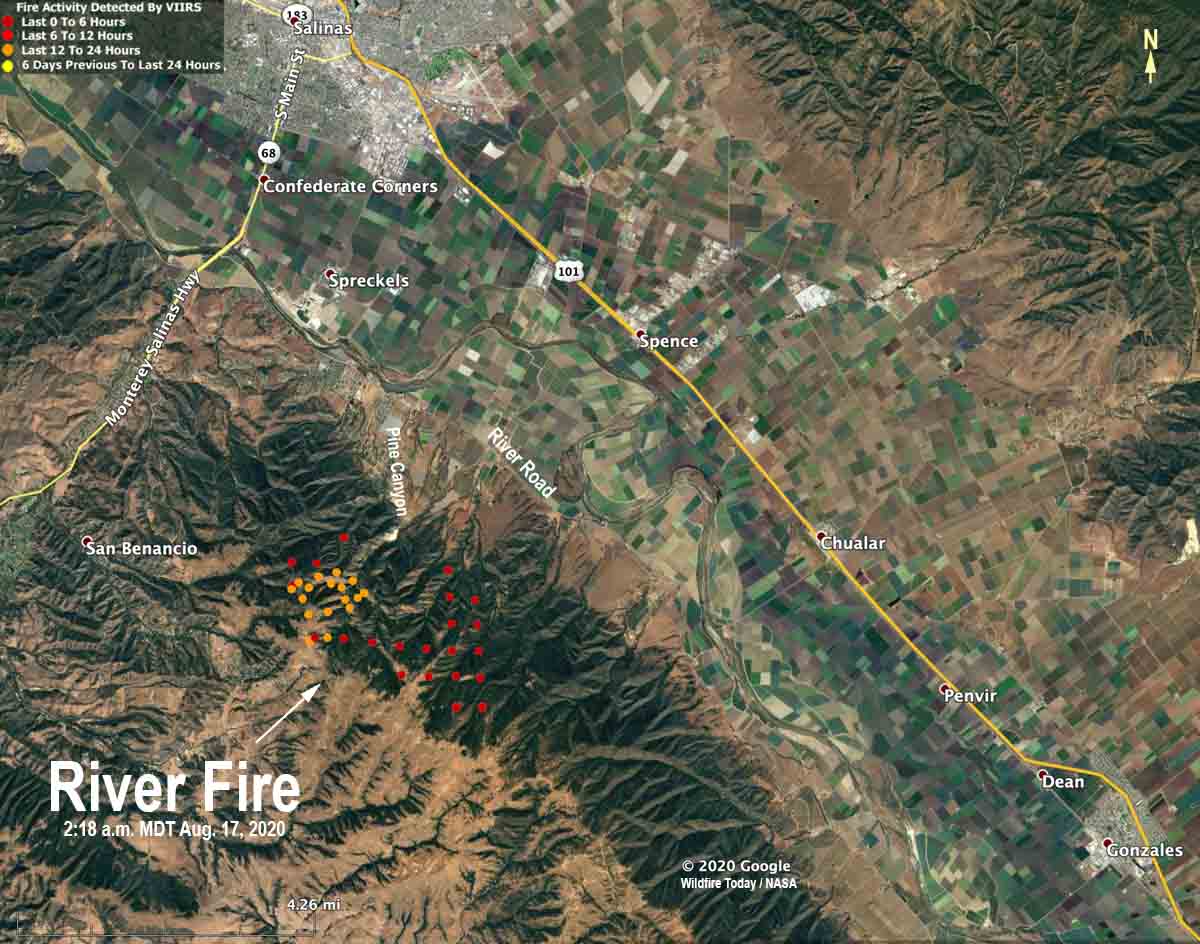
Monday morning at 6 a.m. PDT CAL FIRE reported that the River Fire five miles south of Salinas has burned 2,800 acres and threatens 1,500 structures. Five structures have been damaged but none destroyed. Four firefighters have suffered heat-related injuries.
The fire has crossed Pine Canyon Road, CAL FIRE said, and is moving south toward River Road.
Mandatory evacuations were in effect at 6 a.m. PDT August 17 for Pine Canyon Road, Parker Road, Laurel Lane, and Trimble Hill Lane. The evacuation center is at Buena Vista Middle School, 18250 Tara Drive in Salinas. More information about evacuations can be found at CAL FIRE.
August 16, 2020 | 8 p.m. PDT
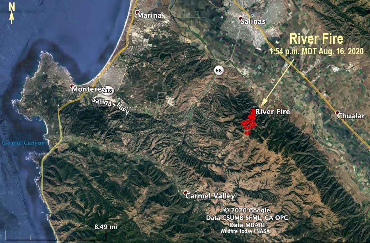
CAL FIRE said at 5:40 p.m. Sunday that the River Fire reported at 3:14 a.m. PDT Sunday morning had burned 500 acres. It is in northern California about 5 miles south of Salinas and 6 miles northeast of Carmel Valley. Evacuations are in effect.
Sunday afternoon the wind recorded at the Rana Creek Tower near the fire was out of the north at 6 to 12 mph with gusts between 12 and 18. After 6 p.m. it switched to come out of the southwest at 10 mph with gusts to 13, pushing the fire to the northeast toward the valley. The relative humidity in the afternoon was around 30 percent with the temperature in the high 80s.
The forecast for Monday is for a high temperature around 90, relative humidity in the afternoon of 35 percent, and wind out of the west at 5 to 10 with gusts up to 21 in the afternoon.
The area has not been visited by fire for many years, so there should be abundant fuel available, offering firefighters a high resistance to control.