California: Etiwanda Fire ignites during wind event

Map of Etiwanda Fire
Map of the Etiwanda Fire, May 2, 2014. Provided by the Incident Management Team.

(UPDATE at 1:55 p.m. MDT, May 2, 2014)

The Incident Management Team is reporting good progress on the Etiwanda fire east of Los Angeles. Better mapping shows that the fire has burned 2,190 acres and the Team is calling it 53 percent contained. The perimeter held successfully overnight. A small flare up occurred near the Smith drainage but was quickly put out. 

The map of the Etiwanda Fire, above, was updated today, May 2.

All mandatory and voluntary evacuations have been lifted and all schools were in session on Friday.

****

(UPDATE at 7:55 p.m. PDT, May 1, 2014)

The Incident Management Team is reporting that the Etiwanda Fire east of Los Angeles has been mapped at 1,627 acres, and they are calling it 53 percent contained; 929 firefighters & support personnel are assigned.

****

(Originally published at 9:50 a.m. May 1, 2014)

The first report of the Etiwanda Fire north of Ranch Cucamonga, California came in at 8:08 Wednesday morning while Santa Ana winds were gusting at 60 to 80 mph. One gust during the day was recorded at 101 mph which qualifies as category 2 hurricane strength. Mandatory evacuations were ordered for 1,650 homes but were cancelled at 5;30 p.m. Voluntary Evacuations are still in effect for Thursday morning for residents north of Hillside Road between Haven Avenue and Milliken Avenue.

Incident Commander Norm Walker is calling the fire 1,000 acres and 10 percent contained.

Today a Red Flag warning continues to be in effect with forecasters expecting northeast winds of 25 to 35 mph with gusts of 40 to 65 mph. The winds will moderate by late afternoon, decreasing to less than 10 mph.The relative humidity will bottom out at 5 percent today and will remain below 20 percent until Friday night. 

The strong winds on Wednesday made it unsafe and impractical for helicopters and fixed wing air tankers to assist firefighters on the ground. Even if they could have safely navigated 150 feet above the rugged terrain in the gusty conditions, the wind would have blown the retardant or water far away from the targets. Strong winds again on Thursday will most likely prevent aerial resources from working the fire, at least until late afternoon when conditions are expected to settle down.

On Tuesday, in spite of a weather forecast for the day of wind gusts exceeding 80 mph, single-digit humidities, and record 95 degree heat, the National Weather Service did not declare a Red Flag Warning until 9:35 Tuesday morning.


Residents who lost structures in 2 California fires file claims against government agencies

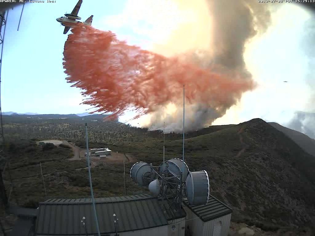
S-2T dropping near electronic site
S-2T air tanker dropping retardant near an electronic site on Mt Laguna at 3:29 p.m. during the Chariot Fire, July 8, 2013. HPWREN photo.

Victims who lost homes and cabins in two fires last year in southern California have filed claims against two public agencies alleging they are responsible for starting the blazes.

Chariot Fire

10News in San Diego is reporting that some of the owners of the 100 cabins that burned at the Al Bahr Shrine Camp east of San Diego on Mt. Laguna are claiming that the fire was started by the operation of a Bureau of Land Management vehicle. The Chariot Fire started July 6, 2013 near the Butterfield Ranch in the Anza-Borrego Desert, 3.000 vertical feet below the community of Mt. Laguna. Managed by CAL FIRE, it burned into the Cleveland National Forest not far from the Mt. Laguna Engine Station. In addition to wiping out many of the structures at the Shrine Camp, it threatened electronic sites at the former Mt. Laguna Air Force Base.

From 10News:

“We’ve hired experts and we’ve done an investigation,” [attorney John] Fiske said. “We believe that a Bureau of Land Management Jeep, driven by a Bureau of Land Management officer, started the fire in the desert and it burned 7,000 acres — the equivalent of 11 square miles.”

Fiske said the experts believe the person driving the Jeep didn’t notice. He has filed a claim against the BLM on behalf of Woodworth, the Al Bahr Shrine Camp and nearly 100 other cabin owners.

Wildfire Today’s coverage, including more photos, of the Chariot Fire.

Powerhouse Fire

From the AP:

Victims of a wildfire that burned 24 homes have sued the Los Angeles Department of Water and Power, claiming the utility started the huge blaze and failed to properly maintain power lines and equipment.

About 100 plaintiffs, ranging from homeowners to a camp for disabled children, filed the lawsuit last month alleging negligence, dangerous condition of public property and other grounds, the Daily News reported Wednesday (http://bit.ly/1lIIUEC).

The plaintiffs are seeking unspecified damages in Los Angeles Superior Court.

The Powerhouse Fire burned 53 structures, including two dozen homes, and more than 30,000 acres near Santa Clarita and in Angeles National Forest. It began May 30 near a hydroelectric power plant and burned for about 10 days.

Wildfire Today’s coverage of the Powerhouse Fire.

A view of the potential in the Oakland Hills through the eyes of an Australian


1991 Tunnel Fire
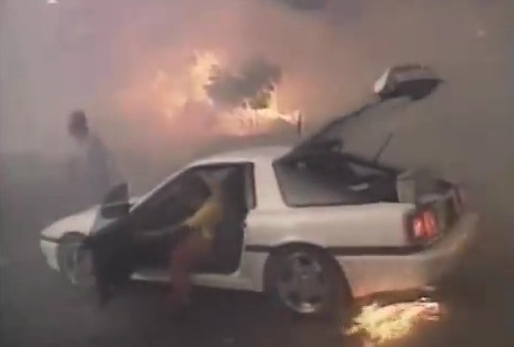
1991 Tunnel Fire. Screen shot from the Oakland Wildfire Prevention Assessment District video below.

The Oakland Hills, which was devastated by the Tunnel Fire in 1991, has some things in common with Australia. The most obvious is the eucalyptus trees, a species imported from down under. The volatile highly combustible oil in the leaves causes fires to burn rapidly under them and through the tree crowns. The eucalyptus contributed to the spread of the Tunnel fire, which killed 25 people, injured 106 residents, and burned 3,354 homes.

Christine Erikson has written about fires in Australia and authored a book titled Gender and Wildfire: Landscapes of Uncertainty. During a visit to the United States in which she made presentations at conferences, she toured the Oakland Hills. Below is an excerpt from an article she wrote about the experience:

…I felt right at home amongst the swaying eucalyptus trees, which despite much controversy still stand tall in the Oakland Hills. Yet, unlike the ‘Prepare, Stay and Defend or Leave Early’ mantra that is associated with living in eucalyptus dominated (i.e. fire-prone) landscapes in Australia, it was the continuing absence of an official policy on how to better prepare residents for future wildfires in the Oakland Hill that loomed large for me during the fieldtrip. What should residents do if evacuation is not a feasible option in the future? How can residents prepare so a similar disaster is prevented? These questions linger like ghosts at every twist and turn of the narrow, winding mountain roads where smoke, embers and flames resulted in accidents and panic that fatally trapped residents in 1991.

This ghostly presence clearly has not escaped the attention of the local Oakland Fire Department. In addition to official projects, the Department is now “unofficially” advising residents on what they can do to increase their chances of survival. Preparing properties in the Oakland Hills, however, is easier said than done. The recommended ten-metre clearance around residential homes is unrealistic in most of these neighbourhoods dominated by quarter acre blocks. A representative from the Oakland Hills Wildfire Prevention program pointed out that when these two-dimensional blocks are considered three-dimensionally, thus taking into consideration the considerable hill slope, these blocks become one-acre properties in need of defence. He furthermore spoke to the frustration of local building-, planning- and fire-codes not supporting each other. The statutory law of developing a given property, for example, sits within a planning code that does not necessarily follow local fire safety recommendations. 

The video below, produced by the Oakland Wildfire Prevention Assessment District, discusses the 1991 Tunnel fire and what the city is doing now to mitigate the vulnerability the area has to the next wildfire.

Video from California National Guard aerial firefighting training


This “B roll” footage is from the April 5th, 2014 California National Guard and Cal Fire Joint training exercise at the Cal Fire Training Academy in Ione, California. It includes shots of helicopter takeoff and landings, air crew members, aircraft refueling, helicopter controls, and California National Guard personnel working with civilian firefighting personnel from CAL FIRE.

Wildfire briefing, April 3, 2014

Three firefighters injured in South Carolina

Three firefighters were injured while fighting a 12-acre wildfire that spread to a structure in Florence County, South Carolina late Wednesday afternoon. One firefighter suffered second and third degree burns to his face and neck while suppressing fire in a mobile home.

wistv.com – Columbia, South Carolina |

Arizona Forestry Division outlines changes for 2014

According to an article at KNAU, Arizona State Forester Scott Hunt told reporters on Wednesday:

“Our first priority is firefighter and public safety. And it’s always going to be our first priority,” he said.

But, Hunt did say that he expects when there is an initial report of a fire that there will “heavier responses” than in the past.

On June 30, 2013, 19 firefighters were killed on the Yarnell Hill Fire which was being managed by the Arizona Forestry Division.

Los Alamos National Laboratory under pressure to move radioacitve waste before wildfire season

From TheState.com:

Los Alamos is under a tight deadline to get nuclear waste off its northern New Mexico campus before wildfire season peaks, and the New Mexico dump [temporarily closed due to a fire] is the federal government’s only permanent repository for waste from decades of nuclear-bomb building.

Aerial firefighting training for California National Guard

California National Guard aerial firefighting training
File photo of California National Guard aerial firefighting training, April, 2010. Photo by Bob Martinez.

Helicopter units of the California National Guard are scheduled to conduct their annual aerial firefighting training Friday through Sunday at the CAL FIRE academny in Ione.

Colorado Senate passes funding bill for aerial firefighting

The Colorado state Senate on Thursday passed a bill that would provide $21 million for a portion of the aerial firefighting program recommended by the Colorado Firefighting Air Corp (CFAC) in a report the agency released on March 28. The funds would enable contracting for four helicopters, four Single Engine Air Tankers, and the purchase of two fixed wing aircraft for fire detection and remote sensing, but not for the two large air tankers called for in the report.

Colorado Governor John Hickenlooper, who has been quoted as saying farmers and ranchers should be the state’s first defense against wildfires, is opposed to spending the additional $11.9 million for contracting for two large air tankers.

Wildfire season begins early in Russia

From ITAR-TASS:

Forest fires have broken out early in a season dubbed “tense this year”, Minister of Natural Resources Sergei Donskoi told a conference chaired by Prime Minister Dmitry Medvedev and addressing preparations for difficult days ahead.

“The situation is tense in Russia this year. Because of low precipitation, the season has begun almost 1.5 months ahead of the norm,” the minister said. Seventeen fires have already been registered across a territory of 2,000 hectares, the minister said.

Citing reasons for danger, the minister noted an early spring and a shallow layer of frozen soil. This was only 40-50% of normal levels and was leaving dry surface soil.

The Ministry of Natural Resources has adopted an inter-regional fire prevention plan employing an additional 3,000-strong contingent of firefighters, 800 units of firefighting equipment and 4,000 fire extinguishers, the minister said.

CAL FIRE moves to peak staffing in Southern California

CAL FIREDespite some rain in march, fire activity remains high

Despite recent rainfall, CAL FIRE continues to respond to a significant increase in wildfires, especially in Central and Southern California where rain totals have done little to combat drought conditions. Starting Monday, March 31, CAL FIRE will move to peak staffing levels in San Diego, Riverside and San Bernardino Counties.

“Even with rain in March, our fire activity has remained 200 percent more over average statewide,” said Chief Ken Pimlott, CAL FIRE director. “The rain has been great, but it has not been enough to make up for our dry winter and California’s drought.

While CAL FIRE never was able to transition out of fire season in 2013, the return to peak staffing means all equipment and facilities will be staffed around the clock. The move comes several months earlier than normal, but is needed as spring temperatures rise and dry out conditions even more.

Between January 1 and March 22, CAL FIRE has responded to over 800 wildfires that have charred nearly 2,300 acres. In an average year for the same time period, CAL FIRE would typically respond to under 275 wildfires for approximately 1,000 acres.

Throwback Thursday

Let’s take a look six years back to see what we were writing about March 23-29, 2008.

—Highlights of the 2008 Annual Wildland Fire Refresher Training.

Wildland Firefighter RefresherTraining 2008
–The After Action Review was released for the Santiago Fire, which was in Orange County, California.

–The U.S. Forest Service Fire Prevention Technician convicted of starting the 137,000-acre Hayman fire in Colorado was re-sentenced to 15 years probation and 1,500 hours of community service.

–A spokesman for North Carolina Division of Forest Resources in Raleigh, said rangers from the division have been allowing a fire to burn on an 18-acre uninhabited island because it doesn’t pose a threat to people or properties.

–A B-1 bomber while landing at Ellsworth Air Force Base had an in-flight emergency and may have dropped burning debris near the base that started multiple wildfires.

–There was an update on the trial of the Crew Boss and Type 3 Incident Commander on the Thirtymile Fire near Winthrop, Washington in 2001. Four members of his crew were overrun by fire and died.

—GAO studies moving US Forest Service to Dept. of the Interior.

—Poway, Calif., Firefighters Were Ordered To Not Fight Fires.

Research: titanium golf clubs can start fires

fire started by golf club
Wildfire at Shady Canyon Golf in Orange County, California, August, 2010, reportedly started by a golf club. Photo by Shady Canyon Golf Club.

In August, 2010 golfers reported that  a 12-acre fire ignited when a golfer, whose ball was in the rough, struck a rock with his club, causing sparks which started the fire. It took hand crews, helicopters, and 150 firefighters to put out the fire at the Shady Canyon Golf Club in Orange County, California.

Following that fire and another one that also may have been started by a golf club, fire investigators in Orange County asked researchers at the University of California to investigate the issue. The report below is from UC Irvine:

****

“Irvine, Calif., March 19, 2014-Titanium alloy golf clubs can cause dangerous wildfires, according to UC Irvine scientists. When a club coated with the lightweight metal is swung and strikes a rock, it creates sparks that can heat to more than 3,000 degrees Fahrenheit for long enough to ignite dry foliage, according to findings published recently in the peer-reviewed journal Fire and Materials.

Orange County, Calif., fire investigators asked UC Irvine to determine whether such clubs could have caused blazes at Shady Canyon Golf Course in Irvine and Arroyo Trabuco Golf Club in Mission Viejo a few years ago.

“One fire almost reached homes before they stopped it. This unintended hazard could potentially lead to someone’s death,” said chemical engineering & materials science professor James Earthman, lead author on the paper. “A very real danger exists, particularly in the Southwest, as long as certain golf clubs remain in use.”

He suspected that the titanium heads on some clubs designed for use in “the rough” – natural areas off irrigated fairways – could be to blame for the fires. Most golf clubs have stainless steel heads. However, a significant number being manufactured or in circulation have a titanium alloy component in the head. Such alloys are 40 percent lighter, which can make the club easier to swing, including when chipping errant balls out of tough spots. In Southern California, those spots are often in flammable scrub brush.

The researchers painstakingly re-created in the lab course conditions on the days of the fires. Using high-speed video cameras and powerful scanning electron microscope analysis, they found that when titanium clubs were abraded by striking or grazing hard surfaces, intensely hot sparks flew out of them. In contrast, when standard stainless steel clubs were used, there was no reaction.

“Rocks are often embedded in the ground in these rough areas of dry foliage,” Earthman noted. “When the club strikes a ball, nearby rocks can tear particles of titanium from the sole of the head. Bits of the particle surfaces will react violently with oxygen or nitrogen in the air, and a tremendous amount of heat is produced. The foliage ignites in flames.”  ”

Photos from the Pine Fire in southern California

Pine Fire. Photo by Jeff Zimmerman.

Jeff Zimmerman was kind enough to send us these excellent photos he took at the Pine Fire in Los Angeles County that started Friday on the south side of Highway 138 in Gorman. The last we heard, on Sunday firefighters were calling it 109 acres and 85 percent contained.

Jeff said the brush and trees in the Los Angeles area really seems to be showing the effects of drought and has not exhibited much change recently in spite of the four inches of precipitation in the last few weeks. The affected vegetation is very noticeable along the Interstate 5 corridor, he said, between the 2,500-foot and 4,400-foot elevation where the bathtub ring of air pollution accumulates.

You can see more of Jeff’s photogaphy at his site. Thanks Jeff.

Pine Fire. Photo by Jeff Zimmerman.

Pine Fire. Photo by Jeff Zimmerman.

Pine Fire. Photo by Jeff Zimmerman.

Pine Fire. Photo by Jeff Zimmerman.

Pine Fire. Photo by Jeff Zimmerman.

Thanks Jeff!