USFS tiptoes back into the night flying business

(Originally published June 4, 2013; revised June 5 to add more details about the staffing of the helicopter and the status of the ownership of the air attack ship.)

The U.S. Forest Service has not had a helicopter with night flying capabilities since around 1980 — until recently. Now there is a night flying ship based on the Angeles National Forest in southern California, designated Helicopter 531.

Aero Commander 690A
File photo, Aero Commander 690A

Three to four night flying helicopters from Los Angeles County and Los Angeles City have been used for the last four nights on the Powerhouse Fire north of Los Angeles. They were coordinated by personnel in another new addition to the USFS’s fleet, a fixed wing air attack ship orbiting overhead in the darkness. It is a Turbo Commander 690, much like the one in the photo. The air attack ship is not USFS owned as reported by the agency, but it is leased on a call when needed contract. It is equipped with technology to support ground and air firefighting operations at night, including an infrared camera and command and control avionics equipment.

The long term goal of the USFS is to retrofit an old agency-owned piston engine Shrike 500 Commander to take the place of the contractor supplied aircraft.

Bell 205A++
A “Helicopter Express” Bell 205A++

Helicopter 531 is a Bell Super 205 equipped with a belly tank and snorkel, supplied under a contract with Helicopter Express of Atlanta, Georgia. The company’s web site says they operate 22 helicopters. During the day to fill its tank it will typically draft water from a water source while hovering. But at night, for safety purposes, it will only refill by landing and filling from a hose staffed by firefighters.

Yes, according to information we received from U.S. Forest Service spokesperson Stanton Florea and someone else closely associated with the operation, the helicopter will be staffed 24 hours a day, using five personnel on each 12-hour shift, changing at 0600 and 1800. There are four 5-person shifts of firefighters, A, B, C, and D, in order to have coverage on days off — a total of 20 firefighters for the helicopter operation, plus pilots.

The helicopter will be flown by one pilot during the day, but will add a co-pilot at night. It will respond to fires with a Captain and two other helitack crewpersons on board while two more travel by ground vehicle.

The helicopter and the air attack ship will work out of Fox Field in Lancaster, California. They can be used on initial attack during the day and night in the southern part of the Los Padres National Forest, and all of the Angeles, San Bernardino, and Cleveland National Forests.

In a news release, U.S. Forest Service Chief Tom Tidwell was quoted as saying:

The re-introduction of Forest Service night helicopter firefighting operations in Southern California further establishes the agency’s commitment to protect lives and property in the region. Night flying operations will provide an aggressive agency initial attack while better ensuring public safety, minimizing overall fire costs and lessening impacts to communities.

Both the Turbo Commander and Helicopter 531 began their contract June 1. While the fixed wing has been in use since then, the helicopter and pilots have been going through training and obtaining certifications and the module is expected to be available at the end of the day on June 5.

The USFS was criticized for attacking the 2009 Station fire near Los Angeles on the first night and the morning of the second day with strategy and tactics that were less than aggressive. The fire was three to four acres at 7 a.m. on the second day, but no air tankers or helicopters were used the first night or until later in the morning on the second day. The fire took off at mid-morning on day two and later burned 160,000 acres and killed two firefighters from Los Angeles County Fire Department. Nearby night-flying helicopters operated by Los Angeles County were not used the first night.

After the Station fire several politicians became involved in the controversy and pressured the USFS to restore the capability to use helicopters at night to drop water. The agency later said they would study the concept, again, and three years after the disastrous fire they announced on August 16, 2012 that they would get back into night flying on a very limited basis with a single helicopter in 2013.

The southern California FIRESCOPE organization and the national forests in the area have established guidelines and procedures for the program. Here is a link to a FIRESCOPE document written in 2007. And below are more recent guidelines from the San Bernardino National Forest. Following the San Bernardino document, there are some excerpts from the FIRESCOPE procedures.
Continue reading

Updated information on the Powerhouse Fire north of Los Angeles

The Powerhouse Fire is burning thousands of acres north of Los Angeles. On Saturday it burned up to and around the communities of Lake Elizabeth and Lake Hughes and Sunday it began transitioning from the mountains out into the Antelope Valley. The current estimate, as of 4 p.m. Sunday, is that the fire has burned about 25,000 acres and is 20 percent contained.

We are putting the most current and detailed information about the fire in our original article, which we update at least once or twice a day. There are also updated maps of the Powerhouse fire at that location.

California: some firefighters released from the Powerhouse Fire

(UPDATE at 6:40 a.m. PT, June 5, 2013)

Since the firefighters are wrapping up the Powerhouse fire north of Los Angeles, this will be the last update unless significant activity occurs.

Residents have been allowed back into all of the communities affected by the fire. Proof of residency is required to gain access behind the road closures. Future fire growth is expected to be minimal. Crews continue to complete line construction, patrol and mop-up. Excess fire resources are being demobilized so they can be ready to respond to other incidents.

  • Structures Destroyed: 16
  • Acres: 32,032
  • Containment: 65%
  • Estimated Cost: $11,400,000

****

(UPDATE at 3:25 p.m. PT, June 4, 2013)

Map of Powerhouse Fire, June 3, 2013
Map of Powerhouse Fire, 10:22 p.m. PT, June 3, 2013

Firefighters are beginning to get a better handle on the Powerhouse Fire north of Los Angeles. Fire spread was minimal overnight with only 24 acres being added. The majority of active fire is along Elizabeth Canyon and Hughes Lake Road northwest to Sawtooth Mountain.

Today crews continued to strengthen fire lines in the southern portion of the fire. Hand crews supported by air resources took advantage of opportunities to construct direct fireline on the west side of the fire. In the Sawtooth Mountain and Sawmill Mountain areas the fire has potential to spread. Fuels in the area have not burned since 1928.

The size is listed at 32,032 acres with 60 percent containment. Some of the resources assigned to the fire include: 2,034 personnel, 155 fire engines, 54 hand crews, 11 helicopters, 27 dozers, 8 air tankers, 33 water tenders. The total estimated cost to date is $8.7 million.

Residents have been allowed to return to the communities of Green Valley, Leona Valley, Elizabeth Lake and Lake Hughes. The evacuation order for the Fairmont area of Antelope Acres was lifted today at noon. Lake Hughes and Elizabeth Lake Canyon Roads remain closed.

Carlton Joseph’s Type 1 Incident Management Team assumed command of the fire Monday at 6 p.m. The fire is being run under a unified command with the U.S. Forest Service, CAL FIRE, and Los Angeles County. In addition to Mr. Joseph, the other Incident Commanders are Dave Richardson, John Tripp, and Phil Veneris.

Helitanker 718, Powerhouse Fire
Helitanker 718 getting water from Elizabeth Lake. Photo by Greg Cleveland.

****

(UPDATE at 5:48 a.m. PT, June 4, 2013)

There has been very little change in the fire perimeter of the Powerhouse Fire over the last 24 hours. Firefighters are cleaning up the fireline and burning out to remove fuels. We will post more details around the middle of the day today.

****

(UPDATE at 9:22 p.m. PT, June 3, 2013)

The Powerhouse fire is now listed at 32,008 acres and 60 percent containment. Today there were 2,185 personnel assigned to the fire. Higher humidities today slowed the spread of the fire, in spite of the strong winds.

****

(UPDATE at 11:43 a.m. PT, June 3, 2013)

The National Weather Service has issued a Wind Advisory which includes the portion of the Powerhouse fire that has burned out into the Antelope Valley. This is not good news for firefighters. The winds are predicted to be out of the southwest at 20 to 30 mph with gusts up to 45. The area near the fire can expect gusts as high as 55 mph. The strongest winds will occur Monday afternoon and evening. Similar conditions will likely redevelop Tuesday afternoon and evening.

****

(UPDATE at 8:38 a.m. PT, June 3, 2013; updated map added)

Map of the north end of the Powerhouse Fire
Map of the north end of the Powerhouse Fire, 12:55 a.m. June 3, 2013 (click to enlarge)

The Powerhouse Fire continued to spread across thousands of acres Sunday after burning around the communities of Lake Hughes and Elizabeth Lake. Firefighters protected hundreds of homes but six burned in the rapidly spreading fire.

Continue reading

White Fire burns through Los Padres Hotshots compound

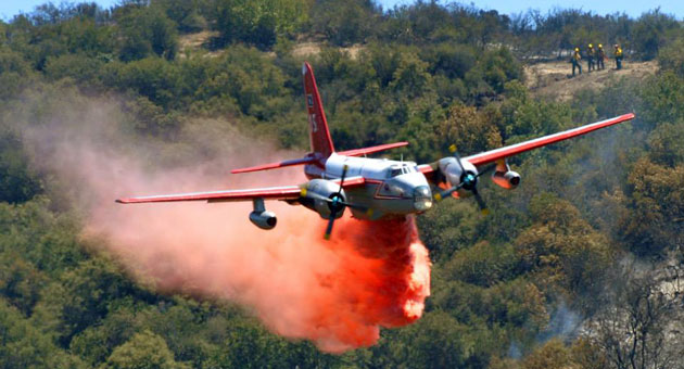
P2V drops on White Fire
A P2V air tanker drops on the White Fire, May 28, 2013. Photo by Mike Eliason, Santa Barbara County FD

(UPDATE at 9:52 a.m. PT, May 29, 2013)

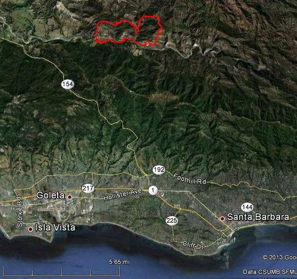
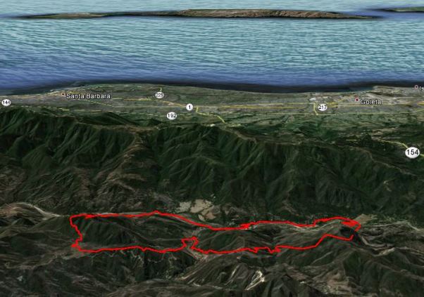
The maps below of the White Fire, 10 miles northwest of Santa Barbara, show the perimeter as of 8:50 p.m. PT on Tuesday. The incident management team has revised the size to 1,858 acres and the containment has increased to 80 percent.

Map of White Fire,
Map of White Fire, (north is at the top), 8:50 p.m. PT, May 28, 2013
Map of White Fire
Map of White Fire, looking south toward Santa Barbara, 8:50 p.m. PT, May 28, 2013

****

(UPDATE at 8:22 p.m. PT, May 28, 2013)

The fire has burned 2,025 acres and is threatening 50 residences, 5 commercial properties, and 50 outbuildings. One residence was damaged. The fire is 65% contained. Today there were 6 air tankers, 2 air attack aircraft, and 5 helicopters supporting firefighters on the ground.
Continue reading

Prescribed fire escapes in California State Park

San Felipe Fire
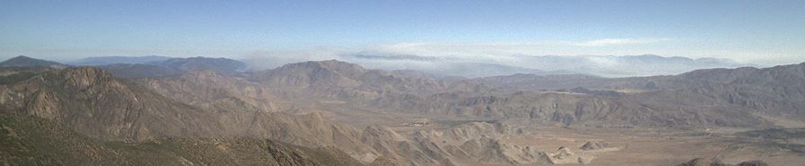
San Felipe Fire as seen from Mt. Laguna at 9:50 a.m. PT, May 5, 2013 (click to enlarge)

(UPDATE at 7:18 a.m. PT, May 26, 2013)

CAL FIRE is reporting the fire has burned 2,650 acres and is 90 percent contained. Resources assigned include 612 personnel, 50 engines, 23 hand crews, 6 dozers and 11 water tenders.

****

(UPDATE at 12:19 p.m. PT, May 25, 2012)

After overnight GPS mapping, the fire is now listed at 1,800 acres and 70 percent containment.

****

(UPDATE at 5:30 p.m. PT, May 24, 2013)

The incident commander of the San Felipe fire northeast of Julian, California is calling it 1,850 acres and 70 percent contained.

****

(UPDATE at 3:27 p.m. PT, May 24, 2013)

The images from the Mt. Laguna camera show that the San Felipe Fire is not putting up as much smoke as it was earlier today. CAL FIRE, in a 2:30 p.m. update, reports that it has grown to 1,800 acres and is still 60 percent contained.

****

(Originally published at 10:25 a.m. PT, May 24, 2013)

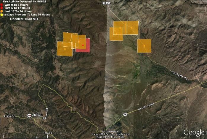
A prescribed fire in Anza Borrego Desert State Park 4 miles northeast of Julian, California got away from firefighters around noon on Thursday. A change in the wind direction is being blamed for the escape, now named  the San Felipe Fire, that as of Thursday evening had burned 1,500 acres and was 60 percent contained.

The Ramona Sentinel reported that CAL FIRE conducted the prescribed fire.

Map of San Felipe Fire Anza Borrego
Map showing the approximate location of San Felipe Fire, heat detected by a satellite at 10:35 p.m. PT, May 23, 2013 (click to enlarge)

As of 6:15 p.m. on Thursday the resources assigned to the San Felipe Fire included 644 personnel, 65 engines, 24 hand crews, 5 air tankers, 7 helicopters, 5 dozers, and 13 water tenders.

An animation of still photos taken from Mt. Laguna Thursday afternoon is available HERE. A window may pop up outside of your browser. It will take a while to load, and it may not work in the Chrome browser.

The latest still image is available HERE.

The fire is in the same general location as the Vallecito Lightning Complex of fires that burned more than 15,000 acres in August.

California utility agrees to pay $37 million for 2007 fire

Southern California Edison (SCE) has agreed to pay $37 million for starting the Canyon Fire in October, 2007 near Malibu, California, which burned 4,565 acres and 22 structures, including the Malibu Presbyterian Church. Investigators determined three utility poles that fell were overloaded with electrical equipment and wires, in violation of state regulations. Under the agreement, SCE would pay a $20 million fine to the state and spend $17 million on improving the safety of their utility pole network.

The agreement still has to be approved by the state utilities commission.

The poles were co-owned and also held equipment for four cell phone companies, AT&T, Verizon, Sprint, and NextG, all of which have already reached agreements about the fire, and expect to pay a total of $26.5 in fines.

Video of burnover on the 1987 Crank Fire

Crank Fire burnover
Crank Fire burnover, screen grab from video

The Wildland Fire Lessons Learned Center has published a video about the burnover of three fire engines and a hand crew that occurred on the 1987 Crank Fire in northern California. Three engines were destroyed. The burnover was captured on video by a fixed wing aircraft that was conducting an aerial retardant study.

Under the direction of the four supervisors, two USFS and two CDF, all 25 firefighters deployed their fire shelters and remained under cover for about 40 to 45 minutes. The injuries which occurred were limited to a few first and second-degree burns, eye irritation, and minor smoke inhalation.

The written report about the burnover can be found HERE.

The burnover occurred on August 30 during the “Siege of 1987″, when lightning in late August started 1,600 fires in northern California and southern Oregon that burned 650,000 acres. Some of the fires burned into October.

California: Grand Fire threatens structures near Frazier Park

Grand Fire 5-15-2013
Map of Grand Fire
Map of Grand Fire, 2-D, perimeter, 9:23 p.m., May 17, 2013
Map of Grand Fire
Map of Grand Fire, 3-D, perimeter, 9:23 p.m., May 16, 2013. Google Earth. Click to enlarge.

(UPDATED @ 8:40 a.m. PT, May 18, 2013)

CAL FIRE reports that there has been little to no increase in fire behavior observed. However, there are still areas of isolated flare ups of unburned islands well within the control lines. Demobilization will continue. There could be delays for resources departing the incident due to the Heartbreak Hundred Bicycle Race taking place in the area.

The updated size is 4,358 acres with 75 percent containment. Resources assigned include 1,853 personnel, 84 engines, 77 hand crews, 11 helicopters, 14 dozers, and 20 water tenders.

****

(UPDATED @ 8:15 a.m. PT, May 17, 2013)

Crews made significant progress overnight on the southern and northern sides of the fire, assisted by lower temperatures and higher humidity. The acreage increase to 4,100 is due to more accurate mapping, and the incident commander is calling it 35 percent contained. The US Forest Service, Kern County and Ventura County are in a Unified Command.

Resources assigned:

  • Total Fire Personnel: 1,452
  • Engines: 65
  • Fire crews: 81
  • Helicopters: 7
  • Dozers: 9
  • Water tenders: 20

****

(UPDATED with new maps at 12:43 p.m. PT, May 16, 2013)

****

(Originally published at 8:46 a.m. PT, May 16, 2013)

The Grand Fire was reported at noon on Wednesday near Frazier Park in southern California and quickly spread through light grass and medium brush, requiring the evacuation of Frazier Mountain High School. The fire remained active until 3 a.m. Thursday.

As you can see by the maps of the Grand Fire above, it is west of Interstate 5 and west of Gorman, about 60 miles northwest of Los Angeles. It is near where the borders of three counties intersect: Ventura, Kern, and Los Angeles.

Grand Fire
Grand Fire, May 15, 2013 Kern County FD photo

At 7 a.m.Thursday the Southern California Geographic Area Operations Center said the fire had burned 2,800 acres as of 3 a.m. and was 25 percent contained. Kern County’s report at 7:20 a.m. said it was 3,500 acres with 15 percent containment and 1,000 firefighters were assigned. Approximately seven air tankers worked the fire Wednesday and six helicopters will be assist firefighters Thursday.

Agencies affected include the Los Padres National Forest, and the counties of Kern and Ventura.

Initial efforts by firefighters Thursday morning will concentrate on the southern edge of the fire with hand lines and dozer breaks on the western edge. Helicopters will be assisting crews on the ground.

CAL FIRE Incident Management Team 6, with Incident Commander Kaslin, has arrived and transition is planned for 6 p.m. today.

KERO TV in Bakersfield has live streaming video of a fire that may be the Grand fire, but these streams come and go and might disappear as news priorities change.

Grand Fire 5-15-2013
Grand Fire May 15, 2013. Photo by Melody Fountain.

Training is underway this week for the two California National Guard C-130 Modular Airborne FireFighting Systems (MAFFS) air tankers based at the 146th Airlift Wing base at Point Mugu in Ventura County. It will be interesting to see if they do some training retardant drops on the Grand Fire which is 46 miles from the base.

New Landsat satellite photographs Springs fire

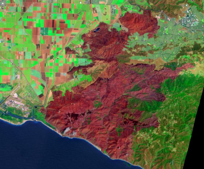
Springs Fire, Landsat photo
Springs fire (in red), photographed May 4, 2013 by Landsat. NASA photo. (click to enlarge)

The new Landsat satellite launched a few months ago photographed the Springs fire that burned 24,251 acres northwest of Los Angeles earlier this month. The photo above was acquired on May 4, two days after the fire started.

At the NASA web site, there are many options for viewing and downloading more detailed images and the ability to click on “View Both Images” which causes a slider to appear enabling you to compare before and after satellite photos of the fire area. You can also download a Google Earth file.

The fire burned very, very close to thousands of homes, but none were destroyed. But 10 outbuildings were destroyed, and 6 commercial structures and 6 outbuildings were damaged. You have to give a lot of credit to the community planning and preparedness of the homeowners for the lack of damage to the residences.