Firefighters battling to keep the Dixie Fire from spreading east

It is closing in on half a million acres.

7:49 a.m. PDT August 10, 2021

Dixie Fire map
Dixie Fire map. The red line was the perimeter at 9:45 p.m. PDT Aug 9, 2021. The yellow areas represent intense heat. Not all of the fire was mapped due to the massive smoke plume up to 22,000 feet.

The Dixie Fire was burning so vigorously at 9:45 Monday night that the smoke plume which had risen to 22,000 feet made it impossible for the small fixed wing mapping plane to obtain good imagery on the northern section of the fire.

North of Highway 36, firefighters are attempting to prevent the north end of the fire from moving east across the A21/A25 Mooney Road. Dozer lines have been constructed to reinforce the road but spot fires have still occurred east of the lines. That is the section of the fire that could not be mapped Monday night.

To see all articles on Wildfire Today about the Dixie Fire, including the most recent, click HERE.

CAL FIRE reported at 7 p.m. Monday that it had burned at least 482,000 acres. However, later fixed wing and satellite imagery indicates it was still growing into the night.

For the last two days the Dixie Fire has been working its way around the southwest tip of the 2020 Sheep Fire, 10 miles southwest of Susanville. On the south side of the Sheep Fire is the scar from the 2007 Moonlight Fire, where the diminished fuels have slowed the spread, but the north side has no recent fire history, resulting in greater fire activity on that side. Our map in an article from August 6 shows the footprint of the Moonlight Fire. The map at the top of this article shows a lighter color of vegetation where that fire burned 14 years ago.

The latest data from crews evaluating damage to infrastructure have found 873 destroyed structures. Maps are available showing the status of structures.

Smoke Monday morning was slow to dissipate, hampering the use of aircraft. In the afternoon wind from the southwest gusting to 20 mph thinned it out, and also increased the fire behavior.

The GOES 17 satellite image, below, shows that the fire was very active at 6:46 p.m. Monday. At that time it was just beginning to form pyrocumulus clouds which later grew, forming a line of condensation that reached to Nevada.

Satellite photo, smoke from fires in Oregon and Northern California
Satellite photo, smoke from fires in Oregon and Northern California at 6:46 p.m. PDT Aug 9, 2021.
Dixie Fire. Satellite photo
Dixie Fire. Satellite photo at 8:26 p.m. PDT Aug 9, showing pyrocumulus stretching to Nevada.

Judge orders PG&E to provide information about possible role in starting the Fly and Dixie Fires

The Fly Fire merged with the Dixie Fire which also appears to have been started by the company’s equipment

firefighters Dixie Fire
Firefighters near the site of a venting propane tank on the Dixie Fire. August 4, 2021. Jay Walter photo.

12:58 p.m. PDT August 8, 2021

The Washington Post reported August 7 that a federal judge ordered PG&E to explain the utility company’s role in starting the Dixie and Fly Fires. The official causes of the fires are still under investigation, but U.S. District Judge William Alsup asked the company in an order issued late Friday to give details, by August 16, about the equipment and vegetation in the area where the fires started. Alsup oversees PG&E’s criminal probation for felony convictions stemming from the deadly 2010 San Bruno gas pipeline explosion.

On July 18 Pacific Gas and Electric (PG&E) told the California Public Utilities Commission (PUC) that on July 13 the company’s equipment may have ignited the Dixie Fire which at 453,000 acres has grown to become the second largest single fire in the recorded history of California.

To see all articles on Wildfire Today about the Dixie Fire, including the most recent, click HERE.

PG&E also said in another filing with the PUC on August 2 that its equipment may also be to blame for starting the Fly fire which eventually merged with the Dixie fire.

The Fly Fire was reported Thursday, July 22 near Keddie in Butterfly Valley about four miles north of Quincy. At first there was a question whether it was a spot fire from the Dixie Fire several miles away, or if it was unrelated. A fire behavior analysis determined the spot fire possibility was unlikely.

PG&E said that at about 5:01 p.m. on July 22 activity on SmartMeters, a line recloser, and alarms reported a problem, and the Gansner 1101 circuit was deenergized. Later PG&E assisted the U.S. Forest Service with moving and examining a tree that was resting on a conductor on the circuit.

Somewhat slowed by smoke, Dixie Fire still spreads further east

6:53 p.m. PDT August 8, 2021

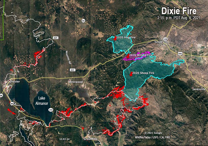
Dixie Fire map 255 p.m. PDT Aug 8, 2021
Map of the Dixie Fire. The white line was the perimeter at 9:58 p.m. PDT August 7, 2021. The red areas indicate intense heat or additional fire growth at 2:55 p.m. PDT August 8.

The wind across the Dixie Fire Sunday afternoon was stronger than it has been in several days. A weather station near Susanville recorded sustained 13 to 16 mph winds out of the southwest and west gusting at 19 to 24 mph. Combined with 12 percent relative humidity and very dry fuels the fire cranked up a head of steam and at 2:55 p.m. was mapped after spreading up to a mile east or northeast in the northeast section of the fire at the edge of the 2020 Sheep Fire.

There was little if any movement into the Sheep Fire footprint, but the Dixie Fire was active going around the corners. Presumably after the 2:55 p.m. flight, the limited spread around the edges of the Sheep Fire continued.

To see all articles on Wildfire Today about the Dixie Fire, including the most recent, click HERE.

At that time it was about 12 miles southwest of Susanville.

Sunday afternoon there was also additional fire spread northeast of Canyondam and northeast of Greenville. There was very limited fire movement in the northwest section of the fire seven miles northeast of Chester.

Maps are available showing the status of structures, and evacuations.

Satellite photo, fires in Northern California
Satellite photo, fires in Northern California, 5:41 p.m. PDT Aug 8, 2021.

The weather forecast indicates conditions favorable for additional fire growth through this week, with warmer temperatures and southwesterly winds.

Continue reading “Somewhat slowed by smoke, Dixie Fire still spreads further east”

Six firefighters injured on the McFarland Fire in Northern California

Suffered burns while attacking spot fire

7:31 p.m. PDT August 7, 2021

McFarland Fire
McFarland Fire. USFS photo published August 6, 2021. (Not related to the injuries)

On Friday August 6, a handcrew was working on the south side of the McFarland Fire when a spot fire ignited ahead of them, the U.S. Forest Service said in a statement released August 7.  While attacking the spot, six firefighters were exposed to some heat that resulted in first degree and minor second degree burns.

Amanda Munsey, one of the Information Officers at the fire, told Wildfire Today that the firefighters were examined by a Division Supervisor who happened to be a former Medical Unit Leader on the Incident Management Team. A helicopter was ordered to transport them to a hospital, Ms. Munsey said, but it was cancelled after it was determined it was not necessary. The six were taken by ground transportation to a hospital in Redding, California. The injuries did not meet the criteria for admittance to a Burn Center, so they were treated and released.

The firefighters will have two or three days off before they resume their duties.

The McFarland Fire is in northwest California on the south side of Highway 36, 5 miles west of Platina, California about an hour and 15 minute drive from Redding. It was one of many fires started from lightning around July 29 and has burned 30,000 acres since then.

The 44,000-acre Monument Fire is 21 miles to the northwest,  20 miles west of Weaverville, and on both sides of Highway 299.

Map of fires in Northwest California
Map of fires in Northwest California. The white lines were the perimeters Aug 7, 2021. The red dots represent heat detected by a satellite at 1:34 p.m. PDT Aug 7, 2021.
Satellite photo Fires Northern California, Oregon, and Washington
Satellite photo at 6:51 p.m. PDT Aug 7, 2021. Fires in Northern California, Oregon, and Washington.

Secretary of Agriculture says we can’t suppress fires and manage forests on the cheap

“We have to have more boots on the ground”

Governor Gavin Newsom and Secretary of Agriculture Tom Vilsack
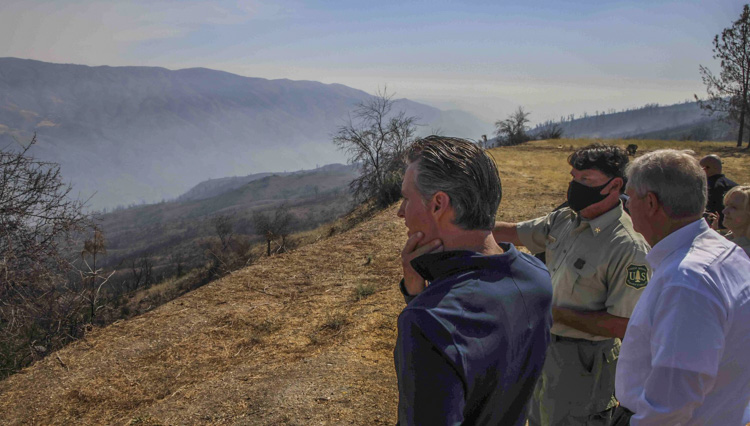
USFS Chief Randy Moore, Governor Gavin Newsom, and Secretary of Agriculture Tom Vilsack, August 6, 2021. Still image from ABC10 video.

On August 4 Governor Gavin Newsom, U.S. Agriculture Secretary Tom Vilsack, and new U.S. Forest Service Chief Randy Moore met at the burn scar of the 2020 August Complex of fires in Northern California to discuss state and federal collaboration on ​wildfire response and fuels management across the West.

During a press availability, Secretary Vilsack uttered words we don’t hear from Chiefs of the Forest Service, or certainly from Secretaries of Agriculture:

We are prepared to do a better job [of forest management] if we have the resources to be able to do this… Candidly, I think it’s fair to say over the generations and decades, we have tried to do this job on the cheap. We have tried to get by, a little here, a little there, with a little forest management here, a little fire suppression over here, but the reality is this has caught up to us.

We have to significantly beef up our capacity. We have to have more boots on the ground… And we have to make sure our firefighters are better compensated. Governor, that will happen.

We need to do a better job, and more, forest management to reduce the risk of catastrophic fire.

Governor Newsom said he has been exploring way to obtain more fire aviation resources, lamented that there are “only a few contracted DC-10s nationwide”, and said he was looking at how “to get the 747 back in our hands, and that’s been a challenge, that thing has been sold, so we’re still working to get some more aerial equipment.” (This statement is queued up in the video below.)

Secretary Vilsack said the Governor’s request for additional aviation resources, “… Came to my desk. One of the challenges we’re working on right now is making sure we get the Defense Department personnel necessary to fly the planes. So sometimes it’s not even the planes, it’s the pilots, the people who know how to fly these planes…I was given instructions to… make sure we have the people in the planes to fly them.”

The Secretary was most likely referring to the military Modular Airborne FireFighting Systems, MAFFS, which can be loaded into C-130 aircraft to temporarily serve as air tankers. They are the only military air tankers used on wildfires in the U.S.  Each requires a seven-person crew, additional support personnel, and often a third conventional C-130 for every two MAFFS that are activated.

The Secretary’s comment could be the explanation for why only five of the eight MAFFS have been activated this year. On July 27, wondering if there was a specific reason why the remaining three were still parked, I asked US Forest Service spokesperson Stanton Florea if the three were available if needed. He replied on July 28, “There are 3 additional MAFFS-equipped C-130s that can be brought into service, if needed.”

As of today, August 6, there are still only five MAFFS working.

Gov. Gavin Newsom and Secretary Tom Vilsack
Gov. Gavin Newsom and Secretary Tom Vilsack tour site of the 2020 August Complex of fires, August 4, 2021. California state government photo.

Dixie Fire spreads east, grows by 110,000 acres

On Friday a layer of smoke partially shaded the fire, slowing the spread

9:41 a.m. PDT Aug. 7, 2021

Dixie Fire 1150 p.m. PDT Aug. 7, 2021
Map of the Dixie Fire at 11:50 p.m. PDT Aug. 7, 2021. Other fires that have occurred since 1980 are also shown. To see the names of some of the fires not labeled, click here.

Environmental conditions on Friday and Friday night resulted in the Dixie Fire, 13 miles northeast of Paradise, California, being much more subdued than we had seen in the previous two days. Smoke from this fire and others in Northern California was trapped by an inversion and provided partial shade. It did not rise, disperse, or be transported into other states. Smoke was thick enough to keep temperatures cooler and humidities higher than earlier this week. It persisted into Friday night causing better humidity recovery, rising to 35 to 65 percent.

To see all articles on Wildfire Today about the Dixie Fire, including the most recent, click HERE.

The forecast for Saturday calls for similar weather conditions. The fire will still be partially shaded by smoke remaining in the area and the winds are expected to be light.

Satellite photo, smoke in Northern California
Satellite photo, smoke in Northern California at 9:11 a.m. PDT Aug. 7, 2021.

The northernmost portion of the Dixie Fire has entered Lassen National Park and is expected to continue burning north through the park. The northeastern section has burned into the 2007 Moonlight Fire and Friday night was very close to the 2020 Sheep Fire and may have burned into it by Saturday morning.

The number of documented destroyed structures has increased to 184, plus another 84 described as minor structures. The Incident Management Teams are still reporting no injuries or fatalities to firefighters or civilians, however some people that were in burned over communities are unaccounted for.

Mapping Friday night determined the fire had burned approximately 446,000 acres, an increase of about 16,000 acres in 24 hours, much less than the growth of 110,000 acres Thursday.

Two Type 1 Incident Management Teams, CAL FIRE Team 1 and California Team 4, are assigned to the fire which has been divided into two zones, East and West.

Resources assigned to the fire Friday evening included 384 fire engines, 124 water tenders, 27 helicopters, 87 hand crews, and 107 dozers for a total of 5,118 personnel. The estimated cost of suppressing the fire so far is $171,000,000.

Continue reading “Dixie Fire spreads east, grows by 110,000 acres”