Lava Fire under a Red Flag Warning Monday afternoon

Monday morning it had burned 1,446 acres 3 miles east of Weed, California

Updated at 9:16 p.m. PDT June 28, 2021

Lava Fire
Lava Fire, from the Antelope Yreka1 camera. Looking southeast toward Mt. Shasta at 3:32 p.m. PDT June 28, 2021. Before it crossed Highway 97.

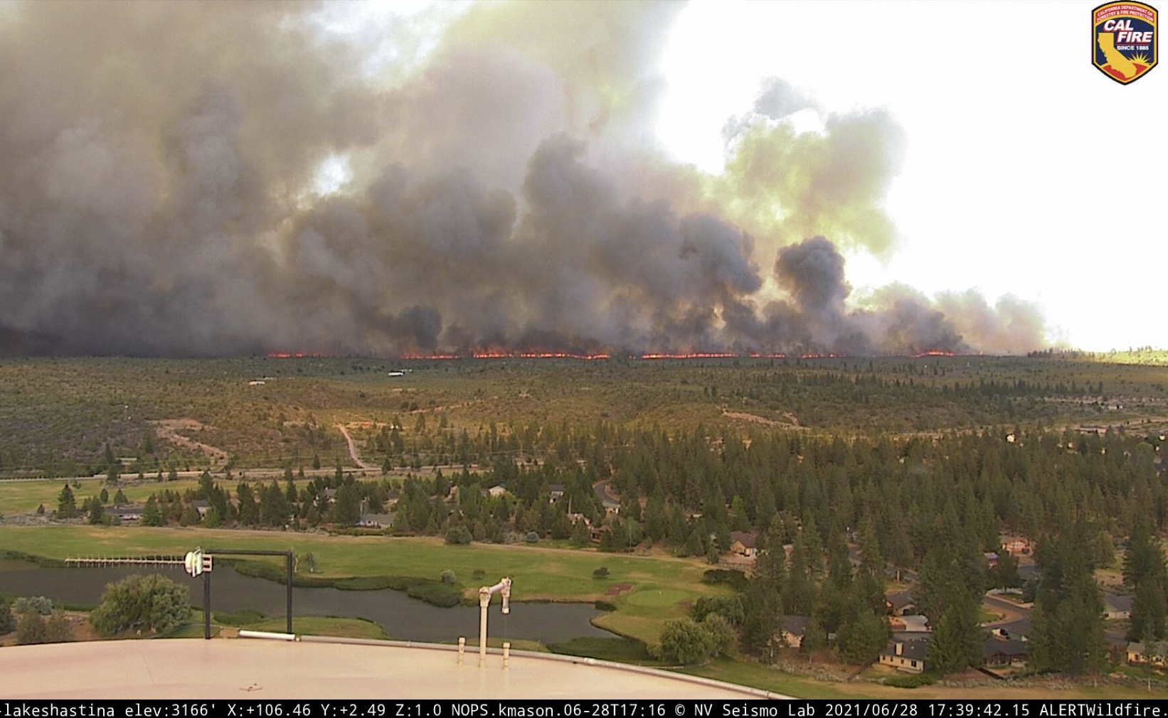
The Lava Fire that was east of Weed, California Monday morning is much larger than it was after being pushed north in the afternoon by winds gusting from 26 to 33 mph. It crossed Highway 97 and kept going. It is difficult to tell how far north it ran until the smoke clears or an infrared mapping aircraft can collect some intelligence overnight.

(To see all articles on Wildfire Today about the Lava Fire, including the most current, click HERE.)

The weather forecast predicts the wind speed will decrease sharply after 10 p.m. Monday night to around 5 mph, and overnight will come out of the east-southeast, then east. Tuesday morning the direction will be variable but will become established in the afternoon to come from the east at 13 to 16 mph gusting to 24 mph. This could spread the fire to the west unless by then firefighters can contain the west flank.

CAL FIRE is mobilizing large numbers of firefighting resources to assist in battling the fire, which burned out of the Shasta-Trinity National Forest after it crossed Highway 97.
Lava Fire
West flank of the Lava Fire, north of Highway 97, at 5:39 p.m. June 28, 2021. Looking east-southeast from the Lake Shastina camera.

Updated at 4:51 p.m. PDT June 28, 2021

A person on Twitter who follows wildland fires closely, CA Fire Scanner,  learned from listening to the Lava Fire’s radio traffic that the fire, spreading rapidly north, has crossed Highway 97 and is well established on the north side.

Approximately five air tankers are working the fire, including Tanker 912, a DC-10.

However this afternoon’s fire run turns out, the weather forecast for Monday night also looks troublesome. After 10 p.m. the wind is expected to shift to come out of the southeast and then east. The speed should decrease from the 29 mph gusts in the afternoon to 5 to 8 mph through the night. This wind direction could push the fire west, threatening communities west of the fire.

smoke from Lava Fire
Satellite photo, smoke from Lava Fire at 4:21 p.m. PDT June 28, 2021.

Continue reading “Lava Fire under a Red Flag Warning Monday afternoon”

Lava Fire burns northwest of Mt. Shasta in Northern California

Three miles northeast of Weed

Updated at 4:47 p.m. PDT June 27, 2021

Lava Fire Map
Map showing the perimeter of the Lava Fire. Mapped by a USFS Cobra Firewatch helicopter at 1:44 p.m. PDT June 27, 2021.

The Lava Fire three miles east of Weed, California was mapped by a US Forest Service Cobra Firewatch helicopter at 1:44 p.m. PDT Sunday and determined that the fire had burned 410 acres.

(To see all articles on Wildfire Today about the Lava Fire, including the most recent, click HERE.)

The high temperature at a weather station northwest of the fire at about the same elevation recorded a high temperature as of 3:53 p.m. of 93 degrees, but still appeared to be rising. The relative humidity in the afternoon was in the teens, the wind speed was 2 to 5 mph, and the direction, as predicted, was all over the place.

Lava Fire smoke convection column pyrocumulus
Lava Fire, smoke column topped by pyrocumulus cloud, June 27, 2021. InciWeb photo.

Sunday afternoon the Lava Fire was putting up an impressive pyrocumulus-topped convection column. The light wind allowed the column to build directly over the fire.

On Monday that breeze will be replaced in the afternoon by strong winds out of the south at 17 mph gusting to 28 while the temperature rises to 96 degrees with 15 percent relative humidity…. a recipe for significant fire growth unless firefighters can get a line around the fire before noon.


Updated at 8:12 a.m. PDT June 27, 2021

map Lava Fire
3-D map showing the APPROXIMATE perimeter of the Lava Fire at 3:18 a.m. PDT June 27, 2021. Looking east.

The Lava Fire near Weed, California was active all night Saturday. A satellite overflight at 3:18 a.m. Sunday showed that it had spread approximately 1 mile further to the south in the previous 12 hours making the overall length about two miles. (See the map above)

Saturday evening the Incident Management Team reported it had burned 220 acres. The heat signatures detected by the satellite at 3:18 a.m indicated that it had grown to at least 400 acres.

Continue reading “Lava Fire burns northwest of Mt. Shasta in Northern California”

Investigation shows California Governor misled the public about fuel reduction projects completed

Prescribed fire fuel break Angeles National Forest
Prescribed fire on the Clear Creek fuel break in the Angeles National Forest in Southern California. ANF photo.

An investigation found that California Governor Gavin Newsom grossly exaggerated the amount of fuel reduction projects that have been completed on state lands, and he reduced the fire prevention budget.

From Capradio, June 23, 2021:

“An investigation from CapRadio and NPR’s California Newsroom found the governor has misrepresented his accomplishments and even disinvested in wildfire prevention. The investigation found Newsom overstated, by an astounding 690%, the number of acres treated with fuel breaks and prescribed burns in the very forestry projects he said needed to be prioritized to protect the state’s most vulnerable communities. Newsom has claimed that 35 “priority projects” carried out as a result of his executive order resulted in fire prevention work on 90,000 acres. But the state’s own data show the actual number is 11,399.

“Overall, California’s response has faltered under Newsom. After an initial jump during his first year in office, data obtained by CapRadio and NPR’s California Newsroom show Cal Fire’s fuel reduction output dropped by half in 2020, to levels below Gov. Jerry Brown’s final year in office. At the same time, Newsom slashed roughly $150 million from Cal Fire’s wildfire prevention budget.”


Update at 6:44 a.m. PDT June 24, 2021

Here are two other points of view:

Willow Fire burns 2,000 acres 12 miles southeast of Big Sur, CA

21 miles west of King City

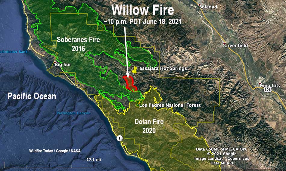
Willow Fire Map California
Willow Fire Map, 10 p.m. PDT June 18, 2021; showing the footprints of the 2016 Soberanes Fire and the 2020 Dolan Fire.

The Willow Fire that started Thursday evening, June 17 has burned approximately 2,000 acres in the Ventana Wilderness in the Los Padres National Forest in Southern California. Friday night it was less than a mile from the facilities at Tassajara Hot Springs.

The fire is 6 miles east of the Pacific Coast, 21 miles west of King City, and 12 miles southeast of Big Sur.

Fixed-wing air tankers and water-dropping helicopters are assisting crews on the ground. The blaze is burning in steep, rugged, and brushy terrain that is accessible only by hiking in.

Willow Fire California June 18
Willow Fire, early evening, June 18, 2021. USFS photo.

The weather forecast for the area on Saturday is for temperatures in the mid-90s, relative humidity in the low teens, and light terrain driven winds becoming southwest and upslope 5 to 10 mph in the afternoon. Sunday will be similar, with slightly lower temperatures and slightly higher RH.

Fire History near the Willow Fire, 2000 to 2020 map
Fire History near the Willow Fire, 2000 to 2020.

Very large recent fires could affect the spread to the south, west, and north. To the west and north is the footprint of the 2016 Soberanes Fire, with the 2020 Dolan Fire to the south. Southeast is the 2008 Indians Fire. It is currently in vegetation that burned in the 2008 Basin Fire; the Soberanes fire spread very well in that footprint which at the time was 8 years old.

There is a corridor to the east with no recent fire history, but if it runs six miles in that direction past Tassajara Hot Springs to East Carmel Valley Road it will enter the scar of the 1993 Rancho Fire with 28-year old brush that may burn very well.

Resources assigned to the fire include 7 hand crews, 12 engines, and 5 helicopters for a total of 337 personnel.

Firefighters are attacking a new fire in the Los Padres NF in California

The Willow Fire has burned more than 700 acres

4:17 p.m. PDT June 18, 2021

Willow Fire map California
Map showing heat detected on the Willow Fire by satellites at 3:36 a.m. PDT June 18, 2021.

The Willow Fire was discovered Thursday at 8:10 p.m. in a remote area of the Ventana Wilderness in the Los Padres National Forest about a mile from Tassajara Hot Springs. Friday at 3 p.m. it was putting up a large column of smoke and had burned an estimated 750 acres.

The fire is 6 miles east of the Pacific Coast, 18 miles west of King City and Highway 101, and two miles north of the Dolan Fire that burned 124,000 acres in August and September of last year.

Willow Fire
Smoke from the Willow Fire as seen from Millers Ranch at 3:37 p.m. PDT June 18, 2021.

From the US Forest Service Friday afternoon:

“There are approximately 300 firefighters on the ground including five Type 1 Interagency Hotshot crews. Air support including fixed-wing air tankers and water-dropping helicopters are assisting crews. The fire is burning in steep, rugged, and brushy terrain accessible only by hiking in.

“The weather is hot and dry with temperatures hovering around 100 degrees with low humidity levels. Winds out of the southwest are 5-10 mph with gusts up to 20 mph. The Arroyo Seco Recreation Area is closed. Tassajara Road is closed from the Tassajara Zen Center to China Camp. Residents have been evacuated from Tassajara Zen Center to China Camp. Arroyo Seco Road is under an evacuation advisory to Carmel Valley Road.”

Willow Fire,
Willow Fire, June 18, 2021. USFS photo, looking west-southwest.

Intanko Fire prompts evacuations east of Yuba City, California

A portion of Beale Air Force Base was evacuated

Updated at 8:50 p.m. PDT June 8, 2021

CAL FIRE reports that the spread of the Intanko Fire 15 miles east-southeast of Yuba City, California has been stopped. It was mapped at 950 acres.


Updated at 5:06 p.m. PDT June 8, 2021

Intanko Fire
Intanko Fire June 8, 2021. As seen from KCRA 3 helicopter at approximately 4:30 p.m. On the left can be seen a portion of a fire that burned on the Beale Air Force Base June 5, 2021.

At 4:51 p.m. Tuesday CAL FIRE reported that the Intanko Fire 15 miles east-southeast of Yuba City, California had grown to 500 acres and was moving north toward Chuck Yeager Road.

Intanko Fire
Intanko Fire at 5:01 p.m. June 8, 2021, as seen from the Penn Valley cam. Looking southeast.


3:47 p.m. PDT June 8, 2021

map Intanko Fire
Location of Intanko Fire, 3 p.m. PDT June 8, 2021

A vegetation fire 15 miles east-southeast of Yuba City, California prompted evacuations Tuesday afternoon. At least one home was destroyed in the fire that was reported a little before 2 p.m. PDT, 32 miles north of Sacramento.

At 3:24 CAL FIRE reported it had burned 300 acres.

Intanko Fire June 8, 2021
Intanko Fire June 8, 2021. CAL FIRE photo.

The fire started south of Beale Air Force base. The AFB Fire Chief ordered all housing residents east of East Garryanna that were in base housing to evacuate to the elementary school parking lot.

On June 5 there was another vegetation fire on the southeast portion of the base.

Intanko Fire
Intanko Fire as seen from the Penn Valley cam at 2:59 p.m. PDT June 8, 2021.
Intanko Fire June 8, 2021
Intanko Fire June 8, 2021. CAL FIRE photo.