January-June, warmest ever

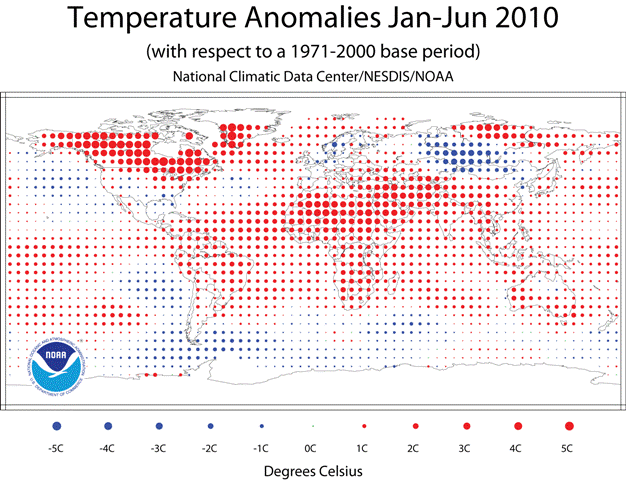
The National Oceanic and Atmospheric Administration has concluded that the first six months of this year were the warmest ever recorded for the combined global land and ocean surface temperatures.

warmest first 6 months global 2010

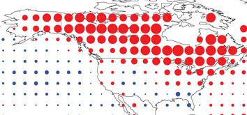
The map below zooms in on North America and shows that areas in the western half of the United States were either one degree C above or below average, while the northeast, Canada, and Alaska were about three to four degrees C above normal for the first six months of this year.

warmest first 6 months north america 2010
NOAA

Climate change brings lightning-caused fires to the North Slope

Two years ago residents of Barrow, on Alaska’s North Slope, saw something they had never seen on the North Slope–lightning. Climate change is bringing lightning, and lightning-caused fires to northern Alaska in quantities never before seen in recorded history. Here is an excerpt from an article at usnews.com.

When it comes to weather, it’s hard to impress the Iñupiat people living at the northernmost tip of our nation. Frozen landscapes, cutting winds, and white-outs are normal in Barrow, Alaska, a small town on the Arctic Ocean about 1,300 miles from the North Pole. But two summers ago, even the oldest residents were startled by something new: flashes of light and powerful booms coming from the sky.

“These people had never seen a lightning storm at Barrow before,” says Gaius Shaver, an Arctic ecologist from the Marine Biological Laboratory’s Ecosystems Center in Woods Hole, Mass. “They didn’t know what to think.”

With temperatures warming an average of 3 to 5 degrees over the past half-century, the climate on the North Slope of Alaska is in transition. Warmer air means more energy is available for thunderstorms where, once, it was just too cold. And more lightning is bringing another dramatic change to the tundra: Wildfires.

“The decade of the 2000s was, by far, the biggest for fires on the North Slope in half a century,” Shaver says. Thirteen wildfires torched nearly 260,000 acres over the decade—more than all the fires recorded and area burned on the North Slope since 1950. And as global warming continues, tundra wildfires are fully expected to increase, both in frequency and acreage burned.

The implications of fire in the Arctic—what Shaver calls “a new disturbance regime”—are profound. “Fire may be the trigger that shifts the North Slope landscape into a new state,” Shaver says—one vastly different from the frozen, treeless tundra of today. And it’s one that may feedback positively to global climate change.

Snowfall does not determine fire season severity in Alaska

When I am asked to predict the severity of the next wildland fire season, I usually say: “Ask me in August and I’ll have a better answer”. If the weather during the fire season is hot, dry, and windy, you will have a busy fire season. If it is not, you won’t.

That is basically what meteorologists in Alaska are saying when they are asked about this winter’s weather which produced one of the lowest snowfalls there in the last 100 years. Here is an excerpt from an article in the News Miner:

FAIRBANKS — The lack of snow this winter doesn’t mean more wildfires this summer.

Despite one of the lowest snowfalls on record in more than 100 years, weather experts say summer weather, not the winter’s snow accumulation, will dictate what kind of fire year Alaska has in 2010.

Studies by the Alaska Fire Service in Fairbanks and fire experts in Canada show there is no relation between winter snowfall and summer fire danger, she said.

“It has more to do with the weather during the fire season,” Sharon Alden, a meteorologist at the Alaska Fire Service, said. “We could have a really low snow year and a really dry spring and then it rains the rest of the summer.”

Meteorologist Mike Richmond, who specializes in fire weather at the National Weather Service in Fairbanks, agreed.

“In the boreal forest of Alaska and Canada there is no relationship between winter snow pack and summer fire danger,” he said.

For example, during the winter preceding Alaska’s biggest fire season on record in 2004, when more than 6.7 million acres burned, Fairbanks received

62.2 inches of snow, which is only about 10 inches below normal.

“We had a near average snow pack and we had our worst fire season ever,” Richmond said.

The picture was much the same the following year, when approximately 4.7 million acres burned after an above-average winter snowfall of 77.4 inches.

Conversely, only 28 inches of snow fell at Fairbanks International Airport during the winter of 2006-07, the third lowest snowfall total on record since 1904, but only 550,000 acres burned in the summer of 2007.

Last winter, Fairbanks received 71.5 inches of snow and approximately 2.95 million acres burned last summer.

With only 24.8 inches of snow as of Friday, Fairbanks is on track for one of its lowest winter snow accumulations since the National Weather Service began keeping records in 1904.

Up to this point, there have been only two winters — 1918-19 with 12.0 inches and 1952-53 with 22.9 inches — in which Fairbanks has recorded less snow than this year.

Fairbanks is experiencing one of its driest winters on record, Richmond said. Only 4.54 inches of precipitation has been measured at Fairbanks International Airport since the start of July.

“This is the fourth-driest period in Fairbanks recorded history from July until now,” Richmond said. “We are in a drought basically.”

But it’s a matter of how dry it is in May, June and July that dictates what kind of fire season Alaska will have.

“It’s all short-term weather process driven,” Richmond said. “If we have rains every two or three weeks or closer together, we don’t get a fire season.

“We have to have periods of three weeks or longer of dry weather for there to be a fire season (in Alaska),” he said. “When we get a dry season, that’s when we get the fires.”

Climate change: beetles, fire, and aspen

There may be discussions about its cause, but there is overwhelming evidence that climate change is having a profound effect on the forests of the world. We don’t have the luxury of debate–it is here.

There may also be profound changes in how we fight fire, where the fires occur, the length of the fire seasons, and the number of personnel and dollars needed to suppress fires. Some of these changes in fire management are already occurring.

Here are some excerpts from an excellent article in the Guardian.

For many years, Diana Six, an entomologist at the University of Montana, planned her field season for the same two to three weeks in July. That’s when her quarry — tiny, black, mountain pine beetles — hatched from the tree they had just killed and swarmed to a new one to start their life cycle again.

Now, says Six, the field rules have changed. Instead of just two weeks, the beetles fly continually from May until October, attacking trees, burrowing in, and laying their eggs for half the year. And that’s not all. The beetles rarely attacked immature trees; now they do so all the time. What’s more, colder temperatures once kept the beetles away from high altitudes, yet now they swarm and kill trees on mountaintops. And in some high places where the beetles had a two-year life cycle because of cold temperatures, it’s decreased to one year.

Such shifts make it an exciting — and unsettling — time to be an entomologist. The growing swath of dead lodgepole and ponderosa pine forest is a grim omen, leaving Six — and many other scientists and residents in the West — concerned that as the climate continues to warm, these destructive changes will intensify.

Across western North America, from Mexico to Alaska, forest die-off is occurring on an extraordinary scale, unprecedented in at least the last century-and-a-half — and perhaps much longer. All told, the Rocky Mountains in Canada and the United States have seen nearly 70,000 square miles of forest — an area the size of Washington state — die since 2000. For the most part, this massive die-off is being caused by outbreaks of tree-killing insects, from the ips beetle in the Southwest that has killed pinyon pine, to the spruce beetle, fir beetle, and the major pest — the mountain pine beetle — that has hammered forests in the north.

These large-scale forest deaths from beetle infestations are likely a symptom of a bigger problem, according to scientists: warming temperatures and increased stress, due to a changing climate. Although western North America has been hardest hit by insect infestations, sizeable areas of forest in Australia, Russia, France, and other countries have experienced die-offs, most of which appears to have been caused by drought, high temperatures, or both.

One recent study collected reports of large-scale forest mortality from around the world. Often, forest death is patchy, and research is difficult because of the large areas involved. But the paper, recently published in Forest Ecology and Management, reported that in a 20,000-square-mile savanna in Australia, nearly a third of the trees were dead. In Russia, there was significant die-off within 9,400 square miles of forest. Much of Siberia has warmed by several degrees Fahrenheit in the past half-century, and hot, dry conditions have led to extreme wildfire seasons in eight of the last 10 years. Russian researchers also are concerned that warmer, dryer conditions will lead to increased outbreaks of the Siberian moth, which can destroy large swaths of Russia’s boreal forest.

While people in some places have the luxury to doubt whether climate change is real, it’s harder to be a doubter in the Rocky Mountains. Glaciers in Glacier National Park and elsewhere are shrinking, winters are warmer and shorter, and the intensity of forest fires is increasing. But the most obvious sign is the red and dead forests that carpet the hills and mountains. They have transformed life in many parts of the Rockies.

It is interesting that normal amounts of precipitation combined with warmer temperatures can translate into drought:

Continue reading “Climate change: beetles, fire, and aspen”

Forest fire carbon emissions grossly overestimated

Researchers are saying that previous researchers’ estimates of carbon emissions from wildfires were seriously overestimated due to erroneous assumptions about the amount of organic material that actually burned. The new research does not go so far to say that “wood smoke is good smoke”, but they do use my new favorite word, “pyrodiversity”.

From the New West:

CORVALLIS, Ore. – A recent study at Oregon State University indicates that some past approaches to calculating the impacts of forest fires have grossly overestimated the number of live trees that burn up and the amount of carbon dioxide released into the atmosphere as a result.

The research was done on the Metolius River Watershed in the central Oregon Cascade Range, where about one-third – or 100,000 acres – of the area burned in four large fires in 2002-03. Although some previous studies assumed that 30 percent of the mass of living trees was consumed during forest fires, this study found that only 1-3 percent was consumed.

Some estimates done around that time suggested that the B&B Complex fire in 2003, just one of the four Metolius fires, released 600 percent more carbon emissions than all other energy and fossil fuel use that year in the state of Oregon – but this study concluded that the four fires combined produced only about 2.5 percent of annual statewide carbon emissions.

Even in 2002, the most extreme fire year in recent history, the researchers estimate that all fires across Oregon emitted only about 22 percent of industrial and fossil fuel emissions in the state – and that number is much lower for most years, about 3 percent on average for the 10 years from 1992 to 2001.

The OSU researchers said there are some serious misconceptions about how much of a forest actually burns during fires, a great range of variability, and much less carbon released than previously suggested. Some past analyses of carbon release have been based on studies of Canadian forests that are quite different than many U.S. forests, they said.

“A new appreciation needs to be made of what we’re calling ‘pyrodiversity,’ or wide variation in fire effects and responses,” said Garrett Meigs, a research assistant in OSU’s Department of Forest Ecosystems and Society. “And more studies should account for the full gradient of fire effects.”

The past estimates of fire severity and the amounts of carbon release have often been high and probably overestimated in many cases, said Beverly Law, a professor of forest ecosystems and society at OSU.

“Most of the immediate carbon emissions are not even from the trees but rather the brush, leaf litter and debris on the forest floor, and even below ground,” Law said. “In the past we often did not assess the effects of fire on trees or carbon dynamics very accurately.”

Even when a very severe fire kills almost all of the trees in a patch, the scientists said, the trees are still standing and only drop to the forest floor, decay, and release their carbon content very slowly over several decades. Grasses and shrubs quickly grow back after high-severity fires, offsetting some of the carbon release from the dead and decaying trees.

Thanks Dick

Wildfire news, November 24

Los Angeles County Fire Chief announces retirement.

P. Michael Freeman today announced that he will be retiring in March, 2010. Chief Freeman has served as Fire Chief with the Los Angeles County Fire Department LACFD for 21 years.

On November 18 the LADFD issued a report about the Station fire that lobbed some criticism towards the U. S. Forest Service for their management of wildland fires.

NASA’s Predator UAV flies burn sites in California

NASA provided this information in a press release:

====================

MOFFETT FIELD, Calif. – NASA’s remotely piloted Predator B aircraft, named Ikhana, recently conducted post-burn assessments of two Southern California wildfire sites, the Piute Fire in Kern County and the Station Fire in the Angeles National Forest. Ikhana, an unmanned aircraft equipped with an infrared imaging sensor, completed a seven-hour imaging flight on Nov. 19, 2009 from NASA’s Dryden Flight Research Center, Edwards Air Force Base, Calif.

The Autonomous Modular Scanner, developed by NASA’s Ames ResearchCenter, Moffett Field, Calif., was carried in a pod under the aircraft’s wing. The scanner operates like a digital camera with specialized filters to detect light energy at visible, infrared and thermal wavelengths.

The scanner operated with a new photo mosaic capability requested by the U.S.Forest Service. A photo mosaic provides easier interpretation for the end user, which in the case of an active wildfire, is the fire incident commander.

Traveling northwest of NASA Dryden, the aircraft flew several data collectionroutes over the area burned by the month-long Piute Fire in Kern County that grew to 37,026 acres before it was contained in July 2008. The burn area is located in the Sequoia National Forest and on Bureau of Land Management public land near Lake Isabella.

Ikhana then traveled southeast to fly image collection routes over the arson-caused Station Fire. It burned more than 160,000 acres in the Angeles National Forest northeast of Los Angeles after being ignited on Aug. 26, 2009. The scanner collected images that will indicate the severity of devastation within the fire area. Another use of the images is for the U.S. Forest Service’s Burned Area Emergency Rehabilitation, or BAER.

The Forest Service uses BAER to reduce further damage to land made unstable by fires, rather than replace what is burned. The BAER data are derived using multi-spectral data available from the Autonomous Modular Scanner on the aircraft. The processes can be changed mid-mission to enable improved collection of critical information, either in mapping active fires or assessing post-burn severity.

The post-burn images collected by the scanner were transmitted through a communications satellite to NASA Ames, where the images were superimposed over Google Earth and Microsoft Virtual Earth maps to better visualize the locations. The images then were made available to the Forest Service for initial assessment of the damage caused by the fires and rehabilitation required.

Scientists prove mega-droughts occurred

By studying mineral deposits in caves, scientists have proved that extended droughts, or “mega-droughts” have occurred hundreds of years ago. The researchers took core samples of deposits left by dripping water in caves, and studied them much like scientists study tree rings to determine fire history.

Their analysis in caves in the Sierra Nevada in California determined that one of the droughts they detected lasted 140-years around the year 1100. The pattern of droughts seems to be associated with rapid climate warming.

Bushfires wreaking havoc in Australia

From The Trumpet:

Thousands of homes are threatened by huge wildfires sweeping across eastern Australia. Record temperatures and persistent winds have combined to make this the worst bushfire threat in 100 years in New South Wales, just months after the country’s most devastating wildfire disaster to date.

The record heat has kindled fears of a repeat of February’s cataclysmic fires in Victoria that killed 173 people and consumed more than 2,000 homes. The conditions have prompted authorities to issue the first “catastrophic” or “Code Red” alert—a new level of warning introduced since the deadly Black Saturday fires in February—for parts of New South Wales and South Australia.

“The very hot temperatures we’ve seen across New South Wales right throughout this last week are simply breaking hundred-year records,” said Rural Fire Service Commissioner Shane Fitzsimmons.

In a Code Red warning, residents cannot be forcibly evacuated, but are strongly advised to leave their property because of the dire risk of death, injury and destruction.

Fire expert Kevin Tolhurst said, “What we saw on (Black Saturday) was an extraordinary day from a weather point of view. We are starting to see those sort of days more frequently.”

Bill introduced in Senate to aid in control of pine beetles

From KPVI news:

U.S. Sen. Mark Udall says the insect infestation killing millions of pine trees in the West is 1 of the region’s “biggest natural disasters.”

The Colorado Democrat said Monday he has introduced a bill to give forest managers more ways to respond.

The bill, co-sponsored by Republican Sen. Jim Risch of Idaho, would allow the U.S. Forest Service to identify high-priority areas and expedite analysis of proposed treatments.

More than 2.5 million acres of pine trees in northern Colorado and southern Wyoming have been killed by tiny beetles that burrow under the bark.

Forest managers say the outbreak poses wildfire and public safety risks.

A national management team will help the Forest Service coordinate responses to the outbreak.

As we reported on November 11, one of the NIMO teams has been activated to assist in battling beetles.

Fewer inmates could hamper fire suppression in California

The state of California is under a court order to reduce their prison population by 40,000 people, from 150,000 to 110,000. In order to comply, Governor Schwarzenegger is seeking legislation to implement alternatives to state incarceration, such as house arrest or utilizing local jails.

A reduction of this size in low risk inmates will mean there will be fewer prisoners available to staff the state’s Type 2 inmate crews. When working on a fire an inmate earns $1 per hour, much less than a CalFire employee, so replacing the crews with CalFire firefighters is not an option in a state with major financial problems.

The reason the court ordered a reduction in the prison population was to improve the treatment of physically and mentally ill inmates. They labeled the care so poor that it violates an inmate’s constitutional rights.