Wildfire briefing July 19, 2013

Seven things to know about fire aviation

Check out the new article over at Fire Aviation about MAFFS, broken CV-580 nose gear, an update on next-gen air tankers, Neptune’s grid test, U.S. Forest Service C-27s, a shortage of lead planes, and an update on the 20,000-gallon 747 Supertanker

Senator Harry Reid talks about fighting fire “on the cheap”

It’s probably not likely that the Majority Leader of the U.S. Senate reads Wildfire Today, but if he had he would have found that we have something in common, an aversion of trying to fight fire “on the cheap”. We have used that phrase many times, and Senator Harry Reid uttered the words Wednesday, according to an article in the Las Vegas Review-Journal in which he was discussing the Carpenter 1 fire just west of Las Vegas:

WASHINGTON — As firefighters head home from Southern Nevada, U.S. Sen. Harry Reid on Wednesday blamed “climate change” for the intense blaze that consumed nearly 28,000 acres and drove hundreds of residents from their homes around Mount Charleston this month.

Reid said the government should be spending “a lot more” on fire prevention, echoing elected officials who say the Forest Service should move more aggressively to remove brush and undergrowth that turn small fires into huge ones.

“The West is burning,” the Nevada Democrat told reporters in a meeting. “I could be wrong, but I don’t think we’ve ever had a fire in the Spring Mountains, Charleston range like we just had.

“Why are we having them? Because we have climate change. Things are different. The forests are drier, the winters are shorter, and we have these terrible fires all over the West.”

“This is terribly concerning,” Reid said. Dealing with fire “is something we can’t do on the cheap.”

“We have climate change. It’s here. You can’t deny it,” Reid went on. “Why do you think we are having all these fires?”

The thrill of covering a wildfire

Jay Calderon, a photographer for MyDesert.com, wrote an article in which he wrote, “Covering a wildfire is one of the more exhilarating things I get to do as a photojournalist.”

A premature and shallow examination of the Yarnell Hill Fire

I have mixed feelings about mentioning a report that has just been released about the Yarnell Hill Fire that killed 19 members of the Granite Mountain Hotshots. But, it is already being referenced in articles, so you may hear about it regardless.

An official investigation is going on now. After it is released we will have much more information about what did, or did not happen that resulted in the tragedy. In spite of the lack of details available, an organization called Pacific Biodiversity Institute wrote a 34-page document expressing the opinions of the authors, Peter H. Morrison and George Wooten. Mr. Morrison’s expertise, according to their web site, is in “conservation biology and ecology with additional expertise in GIS, botany, conservation planning and management”, while Mr. Wooten is described as a “botanist and website developer”.

Their report is shallow, relies on cliches, summarizes the fire behavior describing it multiple times by saying the fire “exploded”, does not understand the nuances of fighting fire or fire behavior, and reaches very detailed and specific conclusions about the vulnerability of hundreds of individual structures based solely on satellite imagery.

So even though they quoted our analysis of the facts about the weather that was recorded by a nearby weather station, and how that could have affected the fire behavior, we can’t recommend their report as authoritative.

Families of Granite Mountain 19 to receive large sums of money

The families of the firefighters that were killed on the Yarnell Hill fire could each receive payments of close to half a million dollars, according to an analysis by NBC News. They came to that conclusion after considering the donations that have been received, the U.S. Justice Department’s Public Safety Officers’ Benefits Programs for law enforcement and fire officers injured or killed in the line of duty, plus Workmen’s Compensation benefits. Hopefully this will do a lot toward taking care of the wives and surviving children.

Unusually high wildfire danger in Scotland

Due to very hot weather (for them) Scotland and other parts of the UK are experiencing many more wildfires than usual. Scotsman.com explains:

Devastating wildfires have ripped through parts of Scotland as the longest heatwave for seven years spread across Britain and forecasters warned temperatures could climb as high as 35C [95F].

Mountain blazes tore across the south Wales’ valleys while flames devastated swathes of Tentsmuir Forest in north east Fife, Scotland, last night, and London experienced its worst grass fires since 2006.

The spate of hot weather is believed to have caused up to 760 premature deaths already and weathermen today warned that the hottest day of the year is yet to come.

John Mayer’s Wildfire

I sometimes check out the hashtag #wildfire on twitter, but for the last few days it has been flooded with something about John Mayer and “Wildfire”. So finally I checked it out, and it’s the name of a new song which has the line “…You and me are catching on like a wildfire”. The video is below.

You may remember that a John Mayer concert in Livingston, Montana earlier this year raised more than $100,000 to help firefighters who battled the 2012 Pine Creek Fire that burned through the community of Pine Creek seven miles south of Livingston August 29, 2012.  He owns a home there but was not in the area when five homes and 8,500 acres burned.

So in my book, he gets a break when he sings about “Wildfire”.

Research: wildland fire smoke, including tar balls, contribute to climate change more than previously thought

Manvendra Dubey
Manvendra Dubey

As soon as they were able to repopulate the facility after being evacuated due to the huge Las Conchas Fire in 2011, scientists at the Los Alamos National Laboratory in northern New Mexico set up an extensive aerosol sampling system to monitor the smoke from the smoldering fire for more than 10 days.  The team used field-emission scanning electron microscopy and energy dispersive X ray spectroscopy to analyze the aerosol samples and determined that spherical carbonaceous particles they called “tar balls” were 10 times more abundant than soot. The Los Alamos scientists were the first to discover tar balls and coated soot.

Senior laboratory scientist Manvedra Dubey noted that, “Most climate assessment models treat fire emissions as a mixture of pure soot and organic carbon aerosols that offset the respective warming and cooling effects of one another on climate. However Las Conchas results show that tar balls exceed soot by a factor of 10 and the soot gets coated by organics in fire emissions, each resulting in more of a warming effect than is currently assumed.” He said this should have a huge impact on how the aerosols are treated in computer models.

These photos of soot particles from the Las Conchas Fire are from a paper written by Mr. Debey and the three other scientists from Los Alamos National Laboratory listed below.

Bare soot particle
Bare soot particle. Los Alamos National Laboratory image.
Embedded soot particle
Embedded soot particle. Los Alamos National Laboratory image.

Mr. Dubey, along with postdoctoral fellow Allison Aiken and post-bachelor’s student Kyle Gorkowski, coordinated with Michigan Tech professor Claudio Mazzoleni (a former Los Alamos Director’s fellow) and graduate student Swarup China to perform the study.

This week on Twitter Mr. Dubey solicited and then answered questions about his fire smoke research:

Lab Chat Q&A Summary

Continue reading

The President talks about climate change and wildfires

On Tuesday President Obama made a major speech at Georgetown University about climate change. Within a few paragraphs, he used the word “fire”, “wildfire”, or “firefighters” five times.

Below is an excerpt from that section of the speech. The entire transcript is HERE.

****

“…The 12 warmest years in recorded history have all come in the last 15 years. Last year, temperatures in some areas of the ocean reached record highs, and ice in the Arctic shrank to its smallest size on record — faster than most models had predicted it would. These are facts.

Now, we know that no single weather event is caused solely by climate change. Droughts and fires and floods, they go back to ancient times. But we also know that in a world that’s warmer than it used to be, all weather events are affected by a warming planet. The fact that sea level in New York, in New York Harbor, are now a foot higher than a century ago — that didn’t cause Hurricane Sandy, but it certainly contributed to the destruction that left large parts of our mightiest city dark and underwater.

The potential impacts go beyond rising sea levels. Here at home, 2012 was the warmest year in our history. Midwest farms were parched by the worst drought since the Dust Bowl, and then drenched by the wettest spring on record. Western wildfires scorched an area larger than the state of Maryland. Just last week, a heat wave in Alaska shot temperatures into the 90s.

And we know that the costs of these events can be measured in lost lives and lost livelihoods, lost homes, lost businesses, hundreds of billions of dollars in emergency services and disaster relief. In fact, those who are already feeling the effects of climate change don’t have time to deny it — they’re busy dealing with it. Firefighters are braving longer wildfire seasons, and states and federal governments have to figure out how to budget for that. I had to sit on a meeting with the Department of Interior and Agriculture and some of the rest of my team just to figure out how we’re going to pay for more and more expensive fire seasons.”

Global greening: another long term effect on wildfires

The predictions that climate change will result in higher temperatures leading to more wildfires has received a lot of attention in the last few years. But one effect that is under the radar is the effect that higher levels of carbon dioxide in the atmosphere will have on wildfires. Your first thought might be that oxygen is an important leg of the heat/fuel/oxygen fire triangle. Higher levels of CO2 might mean lower levels of oxygen which could affect the rate of spread of a fire.

The amount of CO2 in the atmosphere has received some notice recently as the level has approached 400 parts per million, up nearly 22 points from a decade ago, according to NOAA. Here is an excerpt from an article in the LA Times:

Current ratios of carbon dioxide in the Earth’s atmosphere remain at levels not seen in more than 3 million years, when sea levels were as much as 80 feet higher than current levels.

The article I just read at science.nbcnews.com did not mention if oxygen levels will be lower or what that effect may be. But it does say that higher CO2  levels will promote plant growth even in arid areas, which could mean more fuel available for fires and a higher resistance to control.

Analyzing only three decades of data makes it is difficult to attribute increased foliage to higher CO2 levels, but the 11 percent change that the researchers found is pretty interesting.

Below are some excerpts from the article about research by Randall Donohue, an environmental scientist at Australia’s Commonwealth Scientific and Industrial Research Organization:

Increases in CO2 also fertilize plant growth by making more carbon available to plants and allowing plants to lose less water to the air during the process of photosynthesis. Plants need carbon and water for growth. More of both, means more growth, Donohue explained.

To detect the effect in nature, he and colleagues focused on satellite imagery of warm and dry environments around the world where rainfall — the biggest factor in plant growth — is limited. This makes it easier to see vegetation growth in satellite imagery and account for the effect of rainfall.

The greening effect of increased CO2 is a global phenomenon. It is even seen in areas that are getting drier due to reduced rainfall and warmer temperatures as a result of global climate change, the researchers noted.

“If a brown place is getting drier, we can expect that the ‘browning’ won’t be as severe as it would have been if CO2 levels were unchanged,” Donohue explained. “Similarly, we can expect that the greening that would occur when a dry place gets wetter will be greater now because of higher CO2 levels.”

The implications of the findings are potentially significant, he added. For example, it could change how much carbon is soaked up by plants and the amount of woody fuel available for forest fires.

“It needs to be considered as an important piece of the overall global-change puzzle that we are still trying to figure out.”

How climate change may affect wildfires

Changes in area burned w-1 degree C increase in global temp
From National Academy of Sciences. Map of changes in area burned for a 1ºC increase in global average temperature, shown as the percentage change relative to the median annual area burned during 1950-2003. Results are aggregated to ecoprovinces (Bailey, 1995) of the West. Changes in temperature and precipitation were aggregated to the ecoprovince level. Climate-fire models were derived from NCDC climate division records and observed area burned data following methods described in Littell et al. (2009). Source: Figure from Rob Norheim.

Most of us have heard the predictions that climate change and higher temperatures will increase the number of acres burned in wildfires. But I experienced a Holy Crap moment when I saw the map above that illustrates where those changes will occur and by how much. According to a National Academy of Sciences paper titled Climate stabilization targets: emissions, concentrations, and impacts over decades to millennia, a 1°C increase in global average temperature will cause the annual area burned in the western United States to rise from 74 percent to 656 percent relative to the median annual area burned during 1950-2003.

Climate change is happening now, as we told you on January 8, 2013 (and in other articles tagged “climate change”):

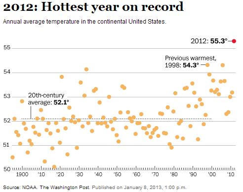
The National Oceanic and Atmospheric Administration (NOAA) is reporting that last year was the hottest on record for the contiguous United States, shattering CRUSHING by a wide margin the previous record set in 1998. The average temperature of 55.3 degrees Fahrenheit was 1 degree above the previous record and 3.2 degrees higher than the average for the 20th century. That is a huge difference.

Average size of wildfires by decadeWhat is wrong with this picture: fires are getting larger, and budgets for fire suppression are decreasing. If the predictions are correct, the number of acres burned will continue to increase even more. The people that beg for our votes and then get sent to congress need to not just write strongly-worded letters about the shortage of fire suppression resources, they need to realize that they hold the purse strings and it is their job to actually take action by approving budgets and passing legislation, instead of what happened in December. Letters are meaningless, meant to be a smoke screen to obscure the reality that little is being accomplished.

****

Below is a brief version of the paper referenced above:

Climate Stabilization Targets, Report in Brief


Record heat in northern and southern hemisphere

Average temperatures, United States

If you are one of the 18 remaining climate change deniers, you should stop reading now, because what follows will make you uncomfortable.

Northern Hemisphere:

Average temperatures, United StatesThe National Oceanic and Atmospheric Administration (NOAA) is reporting that last year was the hottest on record for the contiguous United States, shattering CRUSHING by a wide margin the previous record set in 1998. The average temperature of 55.3 degrees Fahrenheit was 1 degree above the previous record and 3.2 degrees higher than the average for the 20th century. That is a huge difference.

From the Washington Post:

Last year’s record temperature is “clearly symptomatic of a changing climate,” said Thomas R. Karl, who directs NOAA’s National Climatic Data Center. Americans can now see the sustained warmth over the course of their own lifetimes — “something we haven’t seen before.” He added, “That doesn’t mean every season and every year is going to be breaking all-time records, but you’re going to see this with increasing frequency.”

Southern Hemisphere:

Extremely high record-breaking temperatures and “catastrophic” fire danger ratings in Australia are not only contributing to the rapid spread of numerous bush fires, but they may cause some electronic gadgets to stop working. According to Wired, Apple advises that an iPhone should not be used when temperatures reach 95F (35C). In Sydney yesterday the high was 108F (42C).

The extreme weather is also causing problems for meteorologists when they attempt to display the highest ever recorded temperatures on their standard maps.

From Wired:

Australia’s Bureau of Meteorology had to add new colors to its weather map. Now, those unfortunate parts of Australia that achieve temperatures above 122ºF (50ºC) — temperatures that were, until recently, literally off the scale — will be marked in deep purple and terrifying hot pink. It is an interesting moment in data visualization history when climate scientists find themselves in the position of revising the upper bounds of temperatures they ever expected to depict.

It is possible that our electronics and our infrastructure were designed for a climate that we no longer have. When the streets and buildings of lower Manhattan were built, no one expected that they would be flooded by a hurricane. Apple did not design the iPhone for the recent weather in Australia.


Thanks go out to Clyde, Kelly, and Dick

Carbon emissions from fires doubles

Fire, Cascade, South Dakota
Lightning strikes near the Stage Hill Fire, Cascade, South Dakota, July 16, 2012. Photo by Bill Gabbert

NASA has analyzed the the effects of rising temperatures and wildland fire occurrence since 1984 and discovered an impressive fact:

Carbon emissions from [worldwide] fires have grown from an average of 8 teragrams (8.8 million tons) per year from 1984 to 1995 to an average of 20 teragrams (22 million tons) per year from 1996 to 2008, increasing 2.4 times in the latter period.

This is interesting. It documents the rising trend of wildland fire occurrence worldwide that we are are also experiencing in the United States. And since NASA predicts “increased fire activity across the United States in coming decades” it makes a person wonder how we are going to deal with more wildfires when we can’t handle the ones we are currently having.

Below is a news release from NASA:

==================================================

December 4, 2012

Climate Models Project Increase in U.S. Wildfire Risk

WASHINGTON — Scientists using NASA satellite data and climate models have projected drier conditions likely will cause increased fire activity across the United States in coming decades. Other findings about U.S. wildfires, including their amount of carbon emissions and how the length and strength of fire seasons are expected to change under future climate conditions, were also presented Tuesday at the annual meeting of the American Geophysical Union in San Francisco.

Doug Morton of NASA’s Goddard Space Flight Center in Greenbelt, Md., presented the new analysis of future U.S. fire activity. The analysis was based on current fire trends and predicted greenhouse gas emissions.

“Climate models project an increase in fire risk across the U.S. by 2050, based on a trend toward drier conditions that favor fire activity and an increase in the frequency of extreme events,” Morton said.
Continue reading

12 years of fires on one map

Wildland fires, 2001 through July 13, 2012, IDVSolutions

IDV Solutions compiled data from the Moderate-resolution Imaging Spectroradiometer (MODIS) satellite to make this map showing heat produced by fires between 2001 and July 13, 2012 in the United States.  A high resolution version of the map can be found HERE.

IDV Solutions describes the map:

Each dot represents a moment of pretty extreme heat, down to the one square kilometer level (I only retained fires greater than 100KW MW and of those only fires that the system was more than 50% confident of). They’ve been colored and scaled by “units” of the typical American nuclear power plant’s summertime capacity to provide some sort of baseline of the fires’ magnitude.

There are a couple temporal charts in there, too. The seasonal curve I would expect, but the overall upwards trend was interesting (and 2012 is only half through). Is it related to a lag-offset El Niño or La Niña effect?

State of the global climate, 2012

Land and water temperature anomalies

The World Meteorological Orgnaization (WMO) has issued a “Provisional Statement on the State of Global Climate in 2012”. Some of their conclusions about the number of fires differ slightly from the stats we assembled on November 23, 2012.

The WMO’s document is lengthy, but below are some excerpts.

=====================================================

Global average temperature anomaly
Global average temperature anomaly. Credit WMO
Land and water temperature anomalies
Land and water temperature anomalies with respect ro 1961-1990 base period. Credit WMO

Wildfires 

Dry conditions, combined with the heat in the Northern Hemisphere during most of spring and summer 2012, contributed to devastating wildfires. Across the contiguous United States, the number of wildfires throughout the year was the least since 2000; however, the amount of acres burned per fire event during the same period was the largest on record.

Significant wildfires also developed in the Eurasian Continent. In Spain, over 184,000 hectares of land had been scorched by wildfires between January 1st and September 15th, the highest in a decade. The most notable wildfire ignited on September 24th in Valencia, forcing nearly 2,000 people to evacuate. In August 2012, southern parts of Bosnia and Herzegovina recorded a wildfire that burned nearly 5,000 hectares of land, causing nearly 83 million U.S. dollars in damage.

Drought

2012 began with severe to exceptional drought, as defined by the North American Drought Monitor (NADM), across the south central and southeastern contiguous United States and the northern half of Mexico. In the southern Plains of the U.S., the 2012 drought was a continuation of severe drought conditions which developed in 2011. Throughout 2012, drought conditions evolved across the United States, improving in some areas while deteriorating in others.
Continue reading

Wildfire briefing, November 19, 2012

Firefighters discover dog fighting operation

Hawkins Co Fire in Tn, Photo by Hawkins Co EMA
Fire in Hawkins County, Tennessee. Photo by Hawkins County Emergency Management Agency

Firefighters working to put out a wildfire near Rogersville, Tennessee had to suspend their suppression operations after they discovered a facility threatened by the fire that housed dogs and roosters used for dog and cock fighting. Firefighters rescued about 40 of the animals. Here is an excerpt from an article in the Times News:

Hawkins County Sheriff Ronnie Lawson told the Times-News Sunday the suspected operation is now the subject of a criminal investigation, and although no arrests had been made he hoped to be able to release more information about that on Monday.

Murrell added, “It put a damper on the firefighting efforts last (Saturday) night because everybody had to pull off until we found out what it was. Then it took most available law enforcement and fire (personnel) to try to get all the dogs out.”

As of Sunday night the fire, which started on Thursday, had burned about 1,800 acres.

Petition to hire the DC-10 air tankers

The managers of the Facebook page for the DC-10 air tankers have organized a petition drive designed to convince the US Forest Service to award a long-term contract for the DC-10s. More information is at our Fire Aviation web site.

Coal seam fire burns 1,000 acres

A wildfire that started from a mostly underground fire in a coal seam has burned 1,000 acres of land in Boone County, West Virginia. Firefighters are suppressing the fire using leaf blowers, rakes, and dozers. Trees that were down as a result of a summer wind storm and then Hurricane Sandy have added fuel to the fire and complicated access to the area. We have reported on numerous other coal seam fires over the years.

Pole Creek Fire affected the economy of Sisters, Oregon

Some wildfires may enhance the economy of a rural area by spending money at local businesses. But too often tourists stay away in droves or in the case of the Pole Creek Fire near Sisters, Oregon, population 2,000, the dense smoke in the community forced some residents to temporarily leave the area. An article in a Firewise publication reported that even though 800 firefighters were housed at an incident base a few miles down the road, in September restaurants had their revenue decrease by 40 to 50 percent. Stores saw less business and motels experienced reservation cancellations up to five weeks out.

In September we reported on a study about the economic effects of large wildfires which showed that on average, the US Forest Service spent six percent of wildfire suppression funding in the county where the fires occurred. Amounts of local spending varied from zero to 25 percent.

The Pole Cree Fire started from lightning on September 9 and burned 26,795 acres before it was contained October 20.

Fire management decisions affect local communities

When land management agencies make decisions about using less than aggressive initial attack strategies, attempt to manage fires “on the cheap”,  or allow a fire to burn naturally for weeks or months, they may not accurately realize the long term economic and health effects those decisions can have on the local population. These may or may not have been issues in the management of the Pole Creek Fire, but they are too often mentioned as factors that have crept into fire management over the last decade.

World Bank says temperatures may rise 7.2 degrees

The World Bank reported that the planet may see temperatures rise by 4 degrees Celsius, or about 7.2 degrees Fahrenheit by 2100, resulting in more wildfires, extreme heat waves, a decline in food supplies and a ‘life-threatening’ rise in sea level.


Thanks go out to Dick