Meteorologists determine the Creek Fire created two fire tornados

Northeast of Fresno, California earlier this month

Satellite photo showing smoke from fires in California
Satellite photo showing smoke from fires in California at 6:01 p.m. PDT Sept 5, 2020. NASA/Wildfire Today. The Creek Fire

The Creek Fire ran for more than 10 miles and burned 36,000 acres during the first 22 hours after it started at 6 p.m. September 4 northeast of Fresno, California. During that time it created two fire tornados and sent its smoke plume up to 55,000 feet, taller than the tornadic thunderstorms in tornado alley.

An analysis by meteorologists from the National Weather service has revealed that the extreme growth on September 5 generated rare phenomenons — vortices rated at EF2 and EF1, sometimes called fire tornados when they are created by a wildfire.

One was near Mammoth Pool Reservoir and the other was near Huntington Lake. Over 200 people trapped by the fire at Mammoth Pool Reservoir were flown out by courageous National Guard Pilots in helicopters, at times through darkness and smoke.

The NWS personnel rated the vortices based on the effects on trees, including areas where trees were debarked, indicating an EF2 event.

Below is an excerpt from an article by Matthew Cappucci  in the Washington Post.

Jerald Meadows, the warning coordination meteorologist at the Hanford office, said both tornadoes shared common features. “The main contributing factor was the debarking of all the pine trees up with the Mammoth Pool tornado,” Meadows said. “They both uprooted trees to the root balls and snapped large pines. But the [EF1 tornado] did not have any signs of true debarking. We’re probably talking the difference between 100 and 110 miles per hour.”

The Mammoth Pool tornado, which touched down inside the Wagner Campground, snapped several two-foot-diameter trees about 20 to 30 feet above the ground; it was rated as having winds of 115 to 125 mph. The Huntington Lake fire tornado had winds of 90 to 107 mph, and the NWS noted that it was “the result of unprecedented fire activity.”

The article reports that the NWS personnel on duty while the tornados were occurring had concerns about activating their severe weather warning system.

“A tornado warning was considered but not issued,” said [Jerald Meadows, the warning coordination meteorologist at the Hanford Office], who feared that disseminating such an alert might leave people unnecessarily conflicted about deciding whether to shelter or evacuate.

“A tornado warning for a fire opens up a can of worms,” he said. “We want to make sure we’re messaging properly, and we were talking to fire crews letting them know of the circulations we were seeing.”

Before the onslaught of fire tornadoes that has been a hallmark of 2020′s blazes, some National Weather Service offices have had internal discussions and concluded that they would not issue tornado warnings for wildfire-related twisters. While the National Weather Service hasn’t issued specific policy guidance to its 122 forecast offices on how to handle fire tornadoes, Meadows suspects considerable research will be needed to reach a resolution.


This article was edited September 26 to clarify the locations of the fire tornados at Mammoth Pool Reservoir and Huntington Lake.

Thanks and a tip of the hat go out to Tom.

Scientist says more fire tornados are being reported at wildfires this year

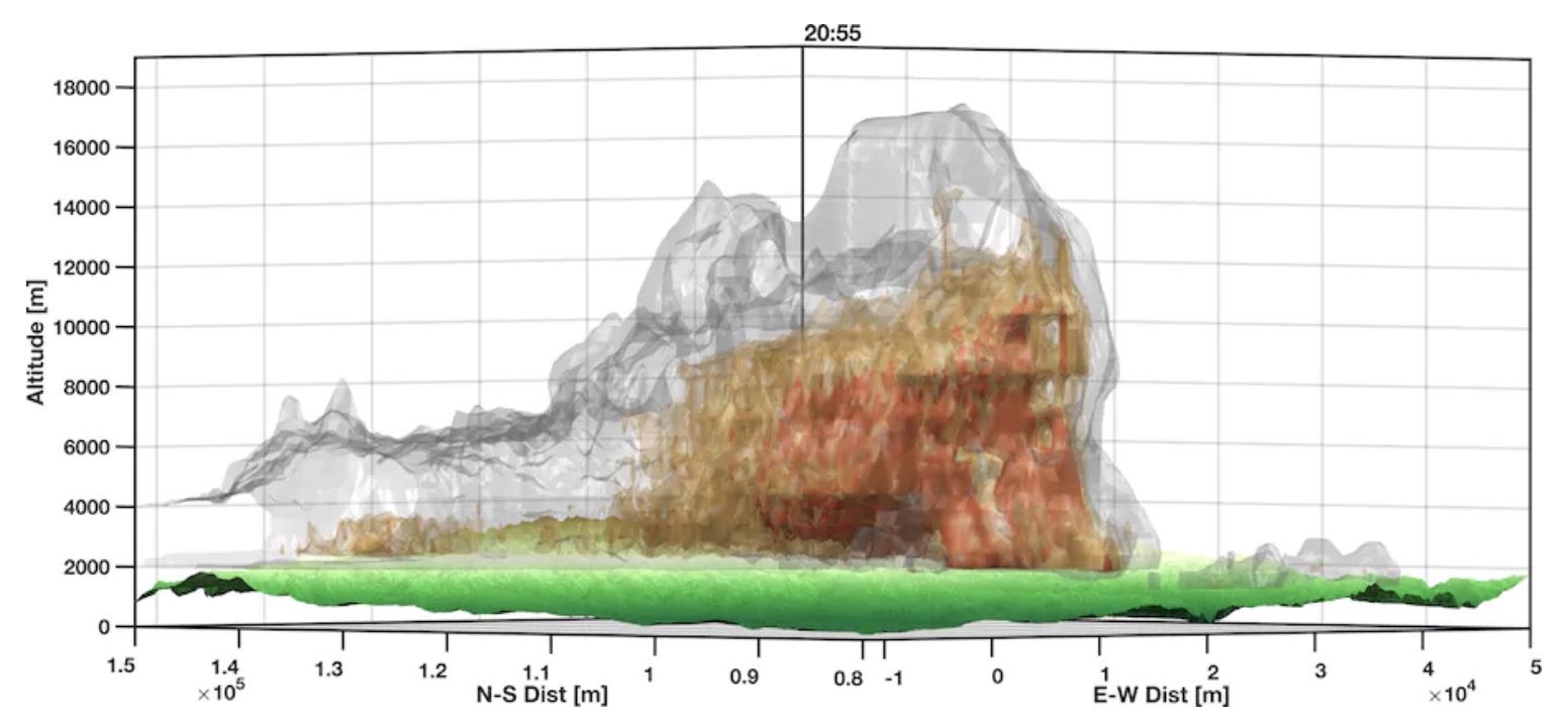
Researcher uses radar data to make three-dimensional maps of smoke plumes

Radar rendering of smoke plume over the Creek Fire
Radar rendering of smoke plume over the Creek Fire. By Neil Lareau, University of Nevada Reno.

The extreme heat caused by a large high pressure system in the West has led to an unusual number of fire tornados.

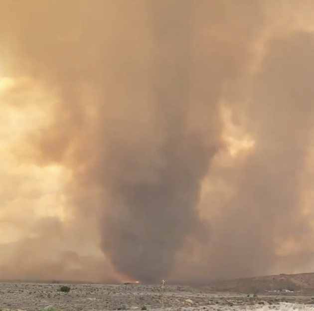
An article in the Washington Post by Matthew Cappucci explains how Neil Lareau, a professor of atmospheric sciences in the department of physics at the University of Nevada at Reno, used detailed weather radar data to make three-dimensional maps of smoke plumes over fires. While it is unusual to have a fire tornado anytime, the data indicates that on at least three fires this year fire tornados have been detected by radar. One was photographed on the Loyalton Fire August 15 about 12 miles northwest of Reno, Nevada. National Weather Service meteorologists who spotted it on radar issued the agency’s first-ever fire tornado warning.

Fire tornado Loyalton Fire
Fire tornado on the Loyalton Fire, by @DVRockJockey August 15, 2020.

Fire tornados and huge smoke plumes topped by massive pyrocumulus clouds are indicators of extreme fire behavior. There is absolutely nothing firefighters or aircraft can do to slow a blaze under those conditions — and those pyrocumulus clouds seem to be occurring more frequently this year.

Creek Fire
Creek Fire September 5, 2020. IMT photo.

The day after the Creek Fire started, its smoke plume grew to 55,000 feet, taller than the tornadic thunderstorms seen in Oklahoma and Kansas in the the spring.

From the Post:

“Anecdotally, this is the deepest that I’ve seen,” said Lareau, who was shocked by the height achieved by the smoke plume. “It’s about a solid 10,000 feet higher than we’re typically seeing with the highest of these plumes.”

Before 2020, only a few fires had ever produced documented fire tornadoes in the United States; now we’re seeing them every week or two. Lareau says the tremendous heights of the wildfires’ clouds, combined with more concerted and astute observation, are factors in the numerous fire tornadoes that have been reported this year. He thinks there may also be some truth to the apparent increase.

“We have a ton of eyes on every fire, looking at every frame, but still, we weren’t seeing these before,” he said. “And we’re seeing all too much of it right now. It’s rather worrying.”

Thanks and a tip of the hat go out to Jim.

100 more people rescued by helicopters as Creek Fire grows to over 140,000 acres

Helicopter pilot said it was, “By far the toughest flying I have ever done.”

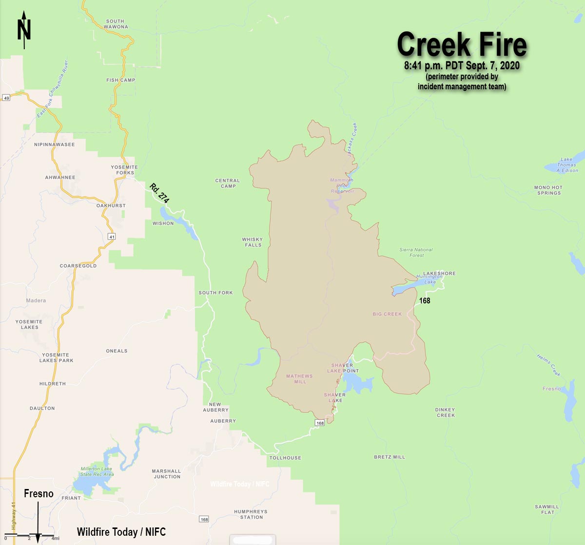
Map of the Creek Fire
Map of the Creek Fire at 8:41 p.m. PDT September 7, 2020.

The Creek Fire 22 miles northeast of Fresno grew explosively Monday, and has now blackened 143,929 acres.

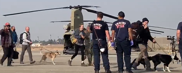
Military helicopters continue to rescue people that are becoming trapped as roads are blocked by the fast moving blaze. In addition to the 224 that were rescued by National Guard helicopters September 5 near Mammoth Pool Reservoir, about 100 more were rescued Monday night and Tuesday morning. The Guard and the U.S. Navy extracted people from the Edison Lake and China Peak areas and took them to the Fresno airport, the Fresno Bee reported. Helicopters that were transporting civilians included Blackhawks, Chinooks, and a Navy Seahawk.

Rescued people arrive at Fresno Creek Fire
People who were rescued from the Creek Fire by Chinook helicopters arrive at Fresno airport September 8, 2020. California National Guard image.

From the Bee, September 8:

Five flights have taken place Tuesday, according to Maj. Jason Sweeney, a spokesman for the California National Guard. More were imminent.

In the latest flights, a U.S. Navy Seahawk helicopter returned 17 people and a dog to Fresno from Edison Lake and a National Guard twin-rotor Chinook helicopter flew back from Edison with 46 people and four dogs. The Navy joined the efforts a short time later, sending a rescue helicopter from Lemoore Naval Air Station to Edison Lake, and returned with 11 people.

Not all of the attempts to rescue people were immediately successful. On some missions poor visibility caused by smoke forced pilots to abort and try again later.

(To see all articles on Wildfire Today about the Creek Fire, including the most recent, click HERE.)

One of the helicopter pilots who rescued people trapped in the fire said in an interview posted at the Bee that he has been shot at while flying for the Army but, “[T]he stress and added workload of going in and out of that fire every time is by far the toughest flying I have ever done.”

At least 65 structures have burned, according to CAL FIRE, and another 5,300 are threatened.

Resources assigned to the Creek Fire include 10 hand crews, 82 fire engines, and 7 helicopters for a total of 846 personnel.

In normal times if there was not competition for firefighting resources nationally due to numerous fires burning at the same time, there would be between 3,000 and 5,000 personnel on a fire this size. In the United States 23,018 are working on fires today, according to the National Interagency Coordination Center. As another example, the Bobcat Fire that is threatening the wildland-urban interface in the Los Angeles area has 85 total personnel and no hand crews three days after it started.

Tuesday’s weather forecast for the Shaver Lake area calls for 79 degrees, 14 percent relative humidity, and wind out of the northwest or north at 10 to 20 mph gusting at 15 to 28 mph — and no chance of rain. Conditions will moderate Tuesday night, and Wednesday will bring 71 degrees, 20 percent RH, and 5 to 8 mph winds out of the southwest.

Creek Fire reaches Mammoth Pool Reservoir; military helicopters rescue over 150 people

More than a dozen had critical injuries

Updated September 7, 2020  |  12:41 p.m. PDT

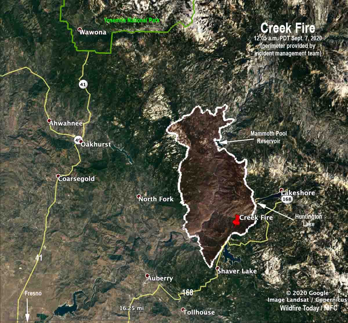
Map of the Creek Fire 12:05 a.m. PDT Sept. 7, 2020
Map of the Creek Fire at 12:05 a.m. PDT Sept. 7, 2020. Perimeter provided by the incident management team.

The Creek Fire Sunday grew in all directions but not as much to the north as might be expected after it ran for over 10 miles in that direction during its first 22 hours. The blaze spread south near the west shore of Shaver Lake but according to mapping at 12:05 a.m. Monday stayed primarily west of Highway 168.

The Incident management team reported at 10:47 a.m. Monday the fire had  burned 78,790 acres.


August 6, 2020  |  4:54 p.m. PDT

Map of the Creek Fire
Map of the Creek Fire at 8:38 a.m. PDT August 6, 2020. The perimeter was supplied by the incident management team.

The perimeter of the Creek Fire on the map above was supplied by the incident management team and is much more accurate than data from satellites. The Forest Service reports it has burned 45,500 acres.

Early Saturday afternoon the fire crossed the San Joaquin River and made a run north to the Mammoth Pool area and beyond. Members of the public sheltered in place near Wagner’s Store and Campground and Mammoth Pool Reservoir. Using helicopters, the California Army National Guard safely evacuated 207 people that were trapped by the fire.

The fire burned actively overnight Saturday and into Sunday morning. Firefighters were challenged Sunday by steep rugged terrain, heavy fuel loading, and high temperatures. Additional resources have been ordered including a Type 1 Incident Management Team. Evacuations and closures remain in effect.

Continue reading “Creek Fire reaches Mammoth Pool Reservoir; military helicopters rescue over 150 people”

Creek Fire grows rapidly near Huntington Lake, California

Burns 36,000 acres in 22 hours

Updated September 5, 2020 | 6:42 p.m. PDT

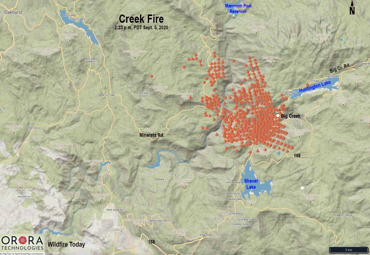
map Creek Fire California Huntington Lake
Map showing heat detected on the Creek Fire by satellites as late as 2:23 p.m. PDT September 5, 2020.

The Creek Fire that has only been burning for about 24 hours in central California is showing explosive growth. The massive multi-layered convection column topped by pyrocumulus is extremely impressive.

(To see all articles on Wildfire Today about the Creek Fire, including the most recent, click HERE.)

The fire is on the Sierra National Forest near the community of Big Creek between Huntington Lake and Shaver Lake, 33 air miles northeast of Fresno.

Creek Fire
Creek Fire September 5, 2020. IMT photo.

At 4 p.m. Saturday afternoon the U.S. Forest Service reported it had burned 36,000 acres and 3,000 structures were threatened — 22 hours after the fire was first reported.

The fire has reached Mammoth Pool Reservoir, 7 miles north of Huntington Lake. People were trapped there with the road blocked by the fire. Click on the photo on the right below.

The smoke has been spreading rapidly north-northwest toward Lake Tahoe.

In the satellite photo taken at 5:21 p.m. PDT the smoke has reached a high enough altitude to clearly show a shadow on the east side.

Satellite photo showing smoke from fires in California
Satellite photo showing smoke from fires in California at 6:01 p.m. PDT Sept 5, 2020. NASA/Wildfire Today.

Firefighters at the scene are challenged by steep rugged terrain, heavy fuel loading, and high temperatures. Additional resources have been ordered including a Type 1 Incident Management Team. Evacuations and closures are in effect.

Creek Fire
The Creek Fire as seen from MeadowLakes, looking northeast at 5:11 p.m. PDT Sept 5, 2020.

30 homes reported destroyed in the Creek Fire

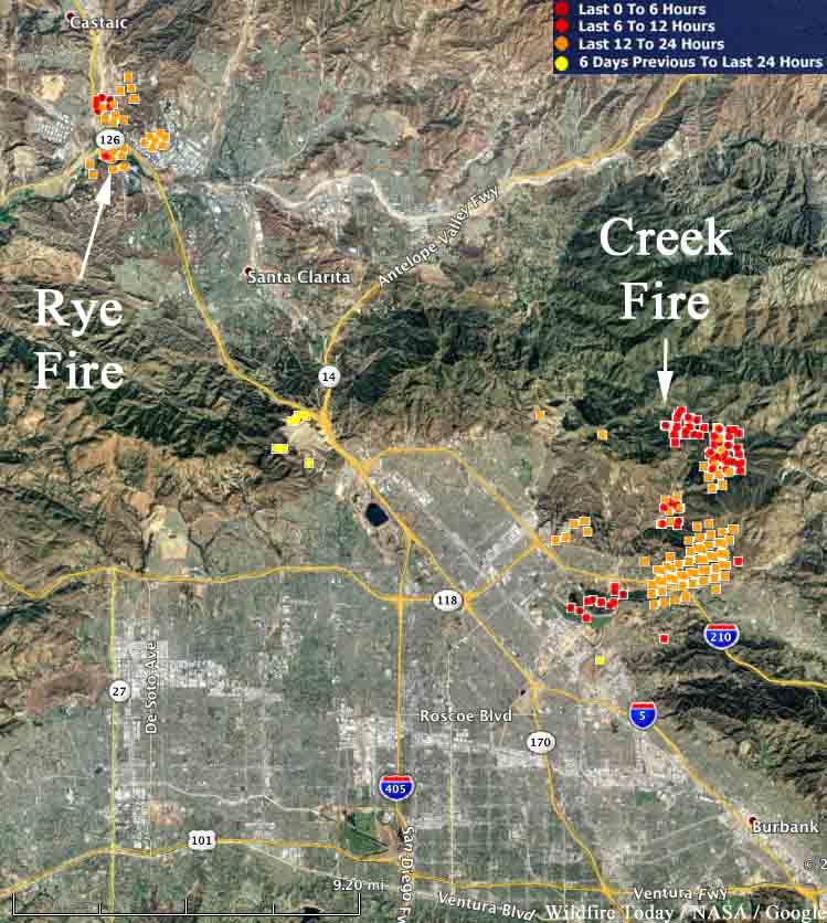
The Creek Fire has burned 11,337 acres in Los Angeles. The nearby Rye Fire in Santa Clarita was mapped at 7,000 acres.

map creek fire rye fire
Map showing heat detected by a satellite on the Creek and Rye Fires in the Los Angeles Area. The red dots are the most recent, detected at 12:40 a.m. PST December 6, 2017. It is likely that some areas with light vegetation burned and then cooled before the heat sensors on the satellite detected them on the subsequent pass, and therefore do not show up.

The Creek Fire on both sides of the 210 freeway in Los Angeles has burned 11,377 acres and destroyed 30 homes. Three firefighters have been injured and 30 horses were killed.

Both sides of the 210 freeway near Sylmar that had been closed, reopened Wednesday morning. The fire started early Tuesday morning in the Kagel Canyon area.

Another fire in the same general area has burned 7,000 acres. The Rye Fire was reported Tuesday morning in Santa Clarita near Castaic Junction, the intersection of Interstate 5 and Highway 126. Officials are considering lifting some of the mandatory evacuation orders. About 775 firefighters are on scene.